
利用接收函数方法约束西沙碳酸盐岩台地沉积厚度与速度结构
|
黄海波 (1987—), 安徽淮南人, 男, 副研究员, 从事南海深部结构研究。email: |
Copy editor: 姚衍桃
收稿日期: 2022-02-16
修回日期: 2022-04-10
网络出版日期: 2022-04-15
基金资助
国家自然科学基金项目(42176081)
国家自然科学基金项目(42174110)
南方海洋科学与工程广东省实验室(广州)人才团队引进重大专项(GML2019ZD0204)
海南省海洋地质资源与环境重点实验室开放课题(HNHYDZZYHJKF003)
Thickness and velocity structures of the carbonate platform sediments in the Xisha Islands constrained by receiver function method
Copy editor: YAO Yantao
Received date: 2022-02-16
Revised date: 2022-04-10
Online published: 2022-04-15
Supported by
National Natural Science Foundation of China(42176081)
Key Special Project for Introduced Talents Team of Southern Marine Science and Engineering Guangdong Laboratory (Guangzhou)(GML2019ZD0204)
Open Project of Hainan Key Laboratory of Marine Geological Resources and Environment(HNHYDZZYHJKF003)
National Natural Science Foundation of China(41274110)
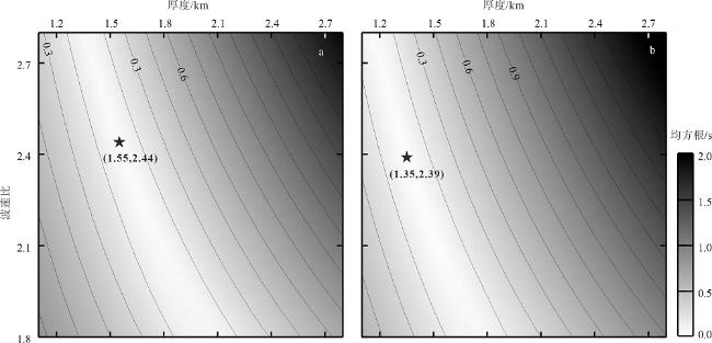
碳酸盐岩台地的沉积厚度和弹性波速度是评估珊瑚礁发育规模以及结构稳定性的重要参数。本文根据西沙地区琛航岛和永兴岛流动地震台站所记录的远震接收函数波形, 通过识别沉积底部产生的转换横波及其多次波震相, 精确拾取震相走时信息。同时参考岛屿钻井资料和人工地震探测结果, 计算获得了台站下方碳酸盐岩台地的沉积厚度、平均纵波速度和波速比。结果显示: 永兴岛和琛航岛下方沉积体的平均纵波速度约为3.5km·s-1, 波速比约为2.42, 平均厚度分别约为1.35km和1.55km。计算获得的平均厚度与西沙钻至基底的测井结果较为一致(约1.257km)。琛航岛沉积厚度略大于永兴岛(约200m), 表明碳酸盐岩台地沉积基底的起伏或与生物礁沉积相的差异有关。
黄海波 , 丘学林 , 龙根元 , 矫东风 , 韩孝辉 . 利用接收函数方法约束西沙碳酸盐岩台地沉积厚度与速度结构[J]. 热带海洋学报, 2023 , 42(1) : 135 -144 . DOI: 10.11978/2022029
Thickness and elastic wave velocity are important parameters for evaluating the size and structural stability of coral reef. This study collected the receiver functions from two portable seismic stations on the Chenhang Island and Yongxing Island in the Xisha area, South China Sea. Travel times of the P-to-S converted waves and their multiple phases generated at the base of the carbonate platform are accurately picked up. At the same time, the thickness, average P-wave velocity, and velocity ratio of the carbonate platform sediments were calculated based on the drilling data and artificial seismic exploration results. The results show that the average P-wave velocity of the platform sediments on the Yongxing Island and Chenhang Island is about 3.5 km·s-1, the Vp/Vs ratio is 2.42, and the average thicknesses are about 1.35 km and 1.55 km, respectively. The calculated thicknesses are consistent with that of the well on the Yongxing Island which reaches the reef bottom at about 1.257 km. The sediment thickness of the Chenhang Island is slightly larger than that of the Yongxing Island (about 200m), which reflects the fluctuation of the basement beneath the island or is related to the reef growth faces.
Keywords carbonate platform; velocity structure; Vp/Vs ratio; receiver function; Xisha Islands
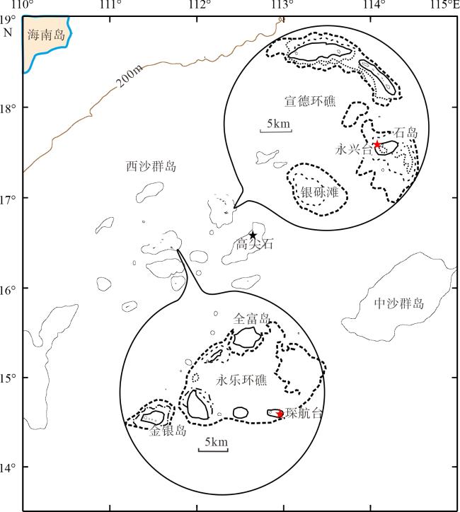
图1 西沙海域岛礁以及岛屿地震台站分布[据陈俊仁(1978)]该图基于国家测绘地理信息局标准地图服务网站下载的审图号为GS(2020)4632号的标准地图制作, 底图无修改。红色五角星为地震台站, 其中永兴台位于宣德环礁, 琛航台位于永乐环礁; 黑色五角星为高尖石 Fig. 1 Distribution of the reef islands in the Xisha area (after Chen, 1978). Red stars are the seismic stations on islands, in which the Yongxing Station lies on the Xuande Atoll and the Chenhang Station lies on the Yongle Atoll; Black star represents the Gaojianshi reef |
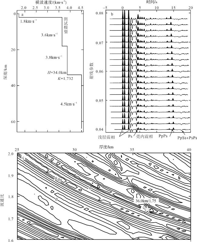
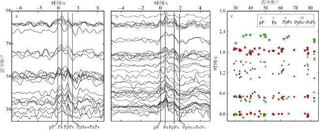
图5 琛航台(a)和永兴台(b)的接收函数波形以及拾取到的转换波走时(c)Pp: 直达P波; Ps: 基底面转换波; PpPs、PpSs+PsPs: 多次转换波。图c中绿色为琛航台数据, 红色为永兴台数据 Fig. 5 The converted and multiple phases from the sedimentary basement in the Chenhang Station (a) and Yongxing Station (b) and the picked travel times (c). Pp: direct P wave; Ps: converted phases from basement; PpPs and PpSs+PsPs: multiple phases |
表 1 琛航台和永兴台的转换横波走时Tab. 1 Travel times of the converted phases from the Chenhang Station and the Yongxing Station |
| 台站 | Ps | PpPs | PpSs+PsPs | ||||||
|---|---|---|---|---|---|---|---|---|---|
| 平均值 | 最小值 | 最大值 | 平均值 | 最小值 | 最大值 | 平均值 | 最小值 | 最大值 | |
| 琛航台 | 0.48 | 0.37 | 0.63 | 1.49 | 1.38 | 1.73 | 2.10 | 2.06 | 2.39 |
| 永兴台 | 0.49 | 0.36 | 0.64 | 1.25 | 1.02 | 1.47 | 1.80 | 1.73 | 1.90 |
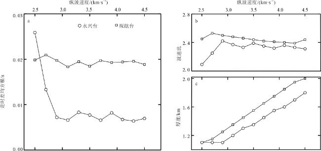
图6 琛航台(a)和永兴台(b)通过搜索估计的沉积厚度和波速比五角星为走时差均方根最小时对应的值(厚度, 波速比); 灰度色标为走时差均方根 Fig. 6 The estimated thickness and velocity ratio of the Chenhang Station (a) and the Yongxing Station (b). The stars represent the thickness and velocity ratio that correspond to the minimum root-mean-square error; gray color scale shows the root-mean-square error distribution |
| [1] |
陈俊仁, 1978. 我国南部西沙群岛地区第四纪地质初步探讨[J]. 地质科学, (1): 45-56.
|
| [2] |
段志刚, 刘成田, 夏丽华, 2016. 水域浅层地震反射波在珊瑚岛礁地层勘察中的应用[J]. 岩土工程技术, 30(3): 113-117.
|
| [3] |
冯英辞, 詹文欢, 姚衍桃, 等, 2015. 西沙群岛礁区的地质构造及其活动性分析[J]. 热带海洋学报, 34(3): 48-53.
|
| [4] |
甘玉青, 肖传桃, 张斌, 2009. 国内外生物礁油气勘探现状与我国南海生物礁油气勘探前景[J]. 海相油气地质, 14(1): 16-20.
|
| [5] |
郭晓然, 赵明辉, 黄海波, 等, 2016. 西沙地块地壳结构及其构造属性[J]. 地球物理学报, 59(4): 1414-1425.
|
| [6] |
黄海波, 丘学林, 胥颐, 等, 2011. 利用远震接收函数方法研究南海西沙群岛下方地壳结构[J]. 地球物理学报, 54(11): 2788-2798.
|
| [7] |
马玉波, 吴时国, 谷明峰, 等, 2010. 西沙海区碳酸盐台地地震反射特征及沉积模式[J]. 海洋学报, 32(4): 118-128.
|
| [8] |
丘学林, 曾钢平, 胥颐, 等, 2006. 南海西沙石岛地震台下的地壳结构研究[J]. 地球物理学报, 49(6): 1720-1729.
|
| [9] |
孙宗勋, 卢博, 1999. 南沙群岛珊瑚礁灰岩弹性波性质的研究[J]. 工程地质学报, 7(2): 175-180.
|
| [10] |
王国忠, 2001. 南海北部大陆架现代礁源碳酸盐与陆源碎屑的混合沉积作用[J]. 古地理学报, 3(2): 47-54.
|
| [11] |
王新志, 2008. 南沙群岛珊瑚礁工程地质特性及大型工程建设可行性研究[D]. 武汉: 中国科学院大学(中国科学院武汉岩土力学研究所): 1-131.
|
| [12] |
魏喜, 贾承造, 孟卫工, 等, 2007. 西琛1井碳酸盐岩的矿物成分、地化特征及地质意义[J]. 岩石学报, 23(11): 3015-3025.
|
| [13] |
魏喜, 贾承造, 孟卫工, 等, 2008. 西沙群岛石岛根管石特征、成因及地质意义[J]. 岩石学报, 24(10): 2415-2422.
|
| [14] |
肖向阳, 张荣, 彭登峰, 2018. 马尔代夫珊瑚礁岩土工程特性研究[J]. 铁道勘察, 44(2): 69-73.
|
| [15] |
解习农, 张成, 任建业, 等, 2011. 南海南北大陆边缘盆地构造演化差异性对油气成藏条件控制[J]. 地球物理学报, 54(12): 3280-3291.
|
| [16] |
杨永康, 丁学武, 冯春燕, 等, 2016. 西沙群岛珊瑚礁灰岩物理力学特性试验研究[J]. 广州大学学报(自然科学版), 15(5): 78-83.
|
| [17] |
余克服, 宋朝景, 赵焕庭, 1995. 西沙群岛永兴岛地貌与现代沉积特征[J]. 热带海洋, 14(2): 24-31.
|
| [18] |
詹文欢, 朱照宇, 姚衍桃, 等, 2006. 南海西北部珊瑚礁记录所反映的新构造运动[J]. 第四纪研究, 26(1): 77-84.
|
| [19] |
张明书, 1990. 西沙西永1井礁相第四纪地层的划分[J]. 海洋地质与第四纪地质, 10(2): 57-64.
|
| [20] |
张明书, 刘健, 李绍全, 等, 1997. 西沙群岛西琛一井礁序列成岩作用研究[J]. 地质学报, 71(3): 236-244.
|
| [21] |
赵强, 2010. 西沙群岛海域生物礁碳酸盐岩沉积学研究[D]. 青岛: 中国科学院大学(中国科学院海洋研究所): 1-181.
|
| [22] |
郑坤, 孟庆山, 汪稔, 等, 2019. 不同结构类型珊瑚礁灰岩弹性波特性研究[J]. 岩土力学, 40(8): 3081-3089.
|
| [23] |
郑坤, 孟庆山, 汪稔, 等, 2020. 珊瑚礁灰岩工程地质特性研究新进展[J]. 海洋地质与第四纪地质, 40(1): 42-49.
|
| [24] |
朱洪翔, 田有, 刘财, 等, 2018. 沉积盆地地区地壳结构估计——预测反褶积方法消除接收函数多次波混响[J]. 地球物理学报, 61(9): 3664-3675.
|
| [25] |
|
| [26] |
|
| [27] |
|
| [28] |
|
| [29] |
|
| [30] |
|
| [31] |
|
| [32] |
|
| [33] |
|
| [34] |
|
| [35] |
|
| [36] |
|
| [37] |
|
| [38] |
|
| [39] |
|
| [40] |
|
| [41] |
|
| [42] |
|
/
| 〈 |
|
〉 |
