
采掘坑对孤立波岸礁水动力特性影响的三维数值模拟研究
|
李俊杰(1997—), 男, 湖南省衡阳市人, 硕士研究生, 主要从事珊瑚礁水动力特性方面研究。email: |
Copy editor: 林强
收稿日期: 2023-03-23
修回日期: 2023-04-28
网络出版日期: 2023-03-13
基金资助
国家重点研发计划课题(2022YFC3103601)
国家自然科学基金重点项目(51839002)
湖南省自然科学基金项目(2021JJ20043)
Three-dimensional numerical simulation of the influence of excavation pit on the hydrodynamic characteristics of solitary wave on fringing reef
Copy editor: LIN Qiang
Received date: 2023-03-23
Revised date: 2023-04-28
Online published: 2023-03-13
Supported by
National Key Research and Development Program of China(2022YFC3103601)
National Natural Science Foundation of China(51839002)
Natural Science Foundation of Hunan Province, China(2021JJ20043)
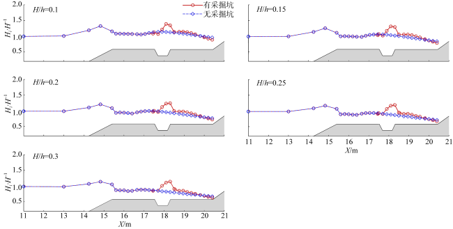
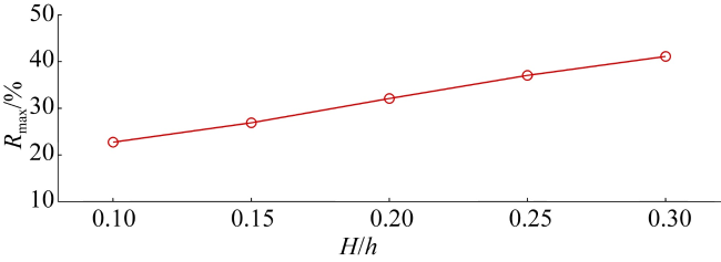
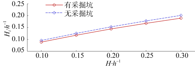
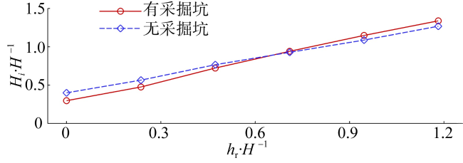
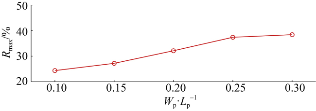
基于非静压模型, 通过开展一系列三维高精度数值计算, 综合考虑入射波高、水深、采掘坑宽度及位置等因素的影响, 深入分析了人工采掘坑对孤立波岸礁水动力特性的影响机制。计算结果表明, 人工采掘坑对孤立波在岸礁上的传播具有一定的阻滞作用, 导致采掘坑附近的局部波高显著增加, 同时也引起岸线附近波高降低。局部波高最大增幅的大小易受入射波高、礁坪水深、采掘坑宽度和位置的影响。入射波高越大, 局部波高最大增幅越大, 礁坪水深越大, 局部波高最大增幅越小, 采掘坑宽度越大, 局部波高最大增幅越大。除此之外, 采掘坑的存在会降低波浪的最大爬高, 但是采掘坑宽度和位置的变化对波浪的最大爬高影响有限。
李俊杰 , 屈科 , 王旭 . 采掘坑对孤立波岸礁水动力特性影响的三维数值模拟研究[J]. 热带海洋学报, 2023 , 42(6) : 42 -51 . DOI: 10.11978/2023005
Based on a non-hydrostatic wave model, a series of three-dimensional high-precision numerical calculations were carried out, and the influence mechanism of artificial excavation pit on the hydrodynamic characteristics of solitary wave over fringing reef was analyzed in depth by comprehensively considering the influence of incident wave height, water depth, the width and location of the excavation pit. The calculation results show that the artificial excavation pit has a certain blocking effect on the propagation of solitary waves on the fringing reef, resulting in a significant increase in the local wave height near the excavation pit, and also causing the wave height near the shoreline to decrease. The maximum rate of increase in local wave height is affected by the incident wave height, submergence water depths of the reef, and the width and location of the excavation pit. The greater the incident wave height, the greater the maximum rate of increase in local wave height, the greater the submergence water depths of the reef, the smaller maximum rate of increase in local wave height, the larger the width of the excavation pit, and the greater the maximum rate of increase in local wave height. In addition, the presence of the excavation pit reduces the maximum wave runup height, but changes in the width and position of the excavation pit have a limited effect on maximum wave runup height.
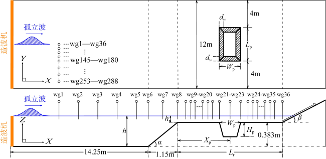
图4 带采掘坑岸礁计算区域布置Fig. 4 Computational layout for fringing reef with an excavation pit |
表1 数值模拟工况表Tab. 1 Parameter setup of numerical simulation |
| 工况 | 入射波高/m | 礁坪水深/m | 采掘坑宽度/m | 采掘坑位置/m |
|---|---|---|---|---|
| A1 | 0.0423 | 0.04 | 0 | 0 |
| A2 | 0.06345 | 0.04 | 0 | 0 |
| A3 | 0.0846 | 0.04 | 0 | 0 |
| A4 | 0.10575 | 0.04 | 0 | 0 |
| A5 | 0.1269 | 0.04 | 0 | 0 |
| B1 | 0.0423 | 0.04 | 0.8 | 2.5 |
| B2 | 0.06345 | 0.04 | 0.8 | 2.5 |
| B3 | 0.0846 | 0.04 | 0.8 | 2.5 |
| B4 | 0.10575 | 0.04 | 0.8 | 2.5 |
| B5 | 0.1269 | 0.04 | 0.8 | 2.5 |
| C1 | 0.0846 | 0 | 0 | 0 |
| C2 | 0.0846 | 0.02 | 0 | 0 |
| C3 | 0.0846 | 0.06 | 0 | 0 |
| C4 | 0.0846 | 0.08 | 0 | 0 |
| C5 | 0.0846 | 0.1 | 0 | 0 |
| D1 | 0.0846 | 0 | 0.8 | 2.5 |
| D2 | 0.0846 | 0.02 | 0.8 | 2.5 |
| D3 | 0.0846 | 0.06 | 0.8 | 2.5 |
| D4 | 0.0846 | 0.08 | 0.8 | 2.5 |
| D5 | 0.0846 | 0.1 | 0.8 | 2.5 |
| E1 | 0.0846 | 0.04 | 0.4 | 2.5 |
| E2 | 0.0846 | 0.04 | 0.6 | 2.5 |
| E3 | 0.0846 | 0.04 | 1.0 | 2.5 |
| E4 | 0.0846 | 0.04 | 1.2 | 2.5 |
| F1 | 0.0846 | 0.04 | 0.8 | 0.4 |
| F2 | 0.0846 | 0.04 | 0.8 | 1.45 |
| F3 | 0.0846 | 0.04 | 0.8 | 3.55 |
| F4 | 0.0846 | 0.04 | 0.8 | 4.6 |
图5 不同时刻速度云图左列为无采掘坑岸礁; 右列为有采掘坑岸礁… Fig. 5 Snapshots of water velocity contour at different time moments. Left side: fringing reef without excavation pit; right side: fringing reef with excavation pit |
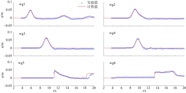
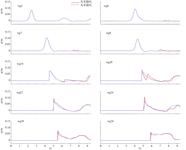
图6 计算区域中心线上不同测点自由液面随时间变化Fig. 6 Time series of water elevations recorded at different wave gauges on the centerline of the domain |
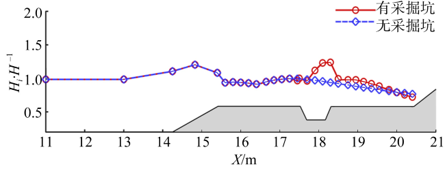
图7 计算区域中心线上最大波高的空间分布Fig. 7 Spatial distributions of the maximum wave height at the centerline of the domain |
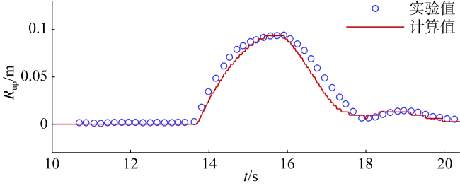
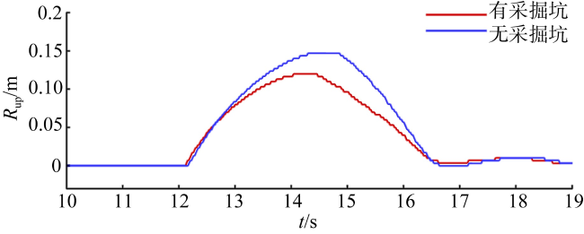
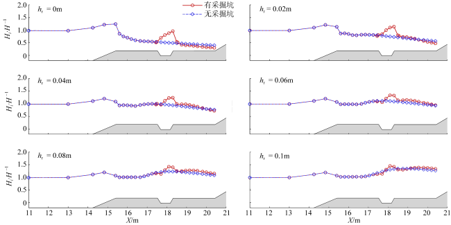
图8 计算区域中心线上波浪爬高随时间变化Fig. 8 Temporal evolutions of wave runup height at the centerline of the domain |
图10 在不同入射波高下计算区域中心线上最大波高的空间分布Fig. 10 Spatial distributions of the maximum wave height at the centerline of the domain under different incident wave heights |
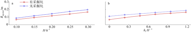
图11 不同入射波高下局部波高最大增幅Fig. 11 Maximum rate of increase in local wave height under different incident wave heights |
图13 不同礁坪水深下计算区域中心线上最大波高的空间分布Fig. 13 Spatial distributions of the maximum wave height at the centerline of the domain under different submergence water depths |
图14 不同礁坪水深下局部波高最大增幅Fig. 14 Maximum rate of increase in local wave height under different submergence water depths |
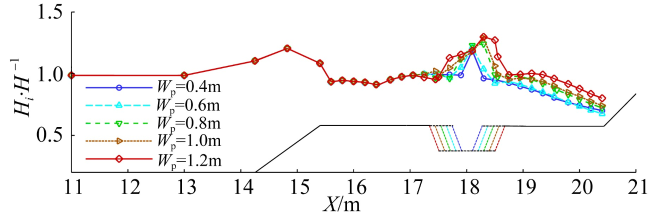
图16 不同采掘坑宽度下计算区域中心线上最大波高的空间分布Fig. 16 Spatial distributions of the maximum wave height at the centerline of the domain under different excavation pit widths |
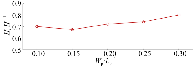
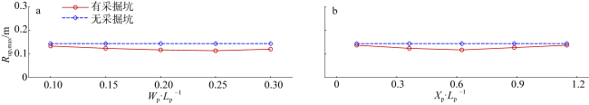
图17 不同采掘坑宽度下局部波高最大增幅Fig. 17 Maximum rate of increase in local wave height under different excavation pit widths |
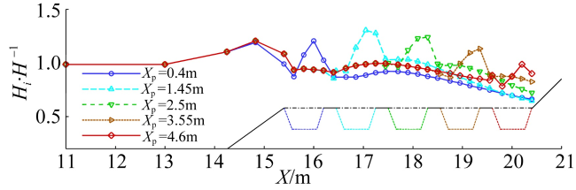
图19 不同采掘坑位置下计算区域中心线上最大波高的空间分布Fig. 19 Spatial distributions of the maximum wave height at the centerline of the domain under different excavation pit locations |
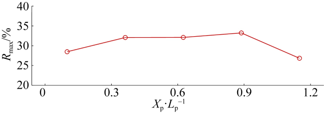
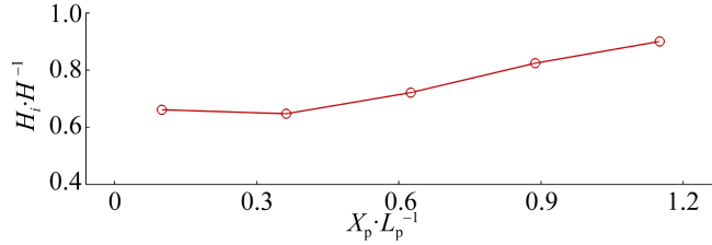
图20 不同采掘坑位置下局部波高最大增幅Fig. 20 Maximum rate of increase in local wave height under different excavation pit locations |
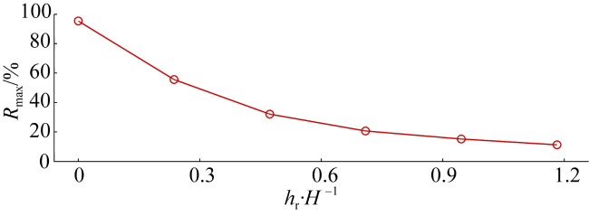
图22 计算区域中心线上最大波浪爬高随入射波高和礁坪水深的变化a. 入射波高的影响; b. 礁坪水深的影响 Fig. 22 Variation of the maximum wave runup at the centerline of the domain with wave heights and submergence water depths. (a) Influence of wave heights; (b) influence of submergence water depths |
| [1] |
|
| [2] |
|
| [3] |
|
| [4] |
|
| [5] |
|
| [6] |
|
| [7] |
|
| [8] |
|
| [9] |
|
| [10] |
|
| [11] |
|
| [12] |
|
| [13] |
|
| [14] |
|
| [15] |
|
| [16] |
|
| [17] |
|
| [18] |
|
| [19] |
|
/
| 〈 |
|
〉 |

