
南海北部被动陆缘洋陆转换带张裂-破裂研究新进展
|
赵明辉(1967—), 女, 辽宁省锦州市人, 博士生导师, 研究员, 研究方向为海洋地球物理。email: |
Copy editor: 殷波
收稿日期: 2023-08-14
修回日期: 2023-09-11
网络出版日期: 2023-09-22
基金资助
国家自然科学基金项目(91958212)
国家自然科学基金项目(41730532)
国家自然科学基金项目(U20A20100)
广东省基金团队项目(2017A030312002)
New developments on the rift-breakup of the continent-ocean transition zone in the northern margin of the South China Sea
Copy editor: YIN Bo
Received date: 2023-08-14
Revised date: 2023-09-11
Online published: 2023-09-22
Supported by
National Natural Science Foundation of China(91958212)
National Natural Science Foundation of China(41730532)
National Natural Science Foundation of China(U20A20100)
Guangdong Natural Science Foundation Research team project(2017A030312002)
文章基于深地震探测数据与大洋钻探资料, 研究了南海北部被动陆缘洋陆转换带张裂-破裂机制科学问题。2018—2023年在国家基金委共享航次的协助下, 实施了三维深地震探测实验, 共投放海底地震仪52台次, 海底电磁仪2台次, 放炮数量达8750炮, 累积获得了294Gb的第一手数据, 并取得了一系列的创新性成果: 1) 首次获得南海北部陆缘洋陆转换带深达上地幔的三维速度结构, 精准确定了研究区洋陆转换带三维空间展布范围宽度为10~20km; 2) 揭示南海北部陆缘异常活跃的岩浆作用, 提出了不同时间段的构造与岩浆相互作用方式, 岩浆活动随着伸展作用不断向洋迁移并逐渐占据主导地位; 3) 建立了边缘海独特的张裂-破裂地质演化模型, 最后一期强烈的岩浆活动导致岩石圈破裂, 形成由玄武岩为主的“鳄鱼嘴”构造, 同时张裂-破裂过程沿其陆缘走向又存在显著的构造-岩浆差异性。
赵明辉 , 袁野 , 张佳政 , 张翠梅 , 高金尉 , 王强 , 孙珍 , 程锦辉 . 南海北部被动陆缘洋陆转换带张裂-破裂研究新进展[J]. 热带海洋学报, 2024 , 43(2) : 173 -183 . DOI: 10.11978/YG2023003
Based upon the deep seismic data and IODP drilling results, this study focuses on the mechanism of rifting and breakup processes of the northern South China Sea. During the implementation of the project (2018—2023), a 3D deep seismic survey was carried out during the Chinese National Natural Science Foundation Open Research Cruise (No. NORC2018-08). A total of 52 ocean bottom seismometers (OBSs) and 2 ocean bottom electro-magnetometers (OBEM) were deployed and a total of 8750 shots were fired. 49 OBSs and 1 OBEM have been recovered, and a large amount of data (294 GB) have been acquired. At the same time, a series of innovative results are obtained: 1) the 3D velocity structure of the COT in the northern margin of the SCS has been obtained for the first time, and the COT domain with width of 10 ~ 20 km is determined in 3D view; 2) the active magmatism was revealed in the northern margin of the SCS, and the styles of interaction between tectonism and magmatism were proposed in different geological stages; meanwhile, the magmatism propagated seaward and progressively increased during extension; 3) the geological model of rifting and breakup is established as the type of marginal seas, whose breakup occurred in a crocodile style dominated by basalt due to the strong magmatism during end-rifting, accompanied with significant along-strike variations in the tectonism and magmatism. This project builds up the opening mode of the SCS from the perspective of 3D deep seismic data, and promotes the Chinese basic research of the marginal sea, which has far-reaching scientific and strategic significances.
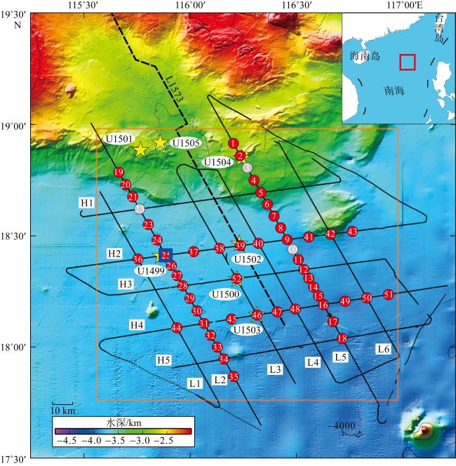
图1 南海北部陆缘IODP 367/368/368X钻探区的三维OBS深地震探测实施成果图右上角插图基于自然资源部标准地图服务网站下载的审图号为GS(2016)1665号标准地图制作。红色和灰色圆圈为分别为成功回收和丢失的OBS台站, 其上数字为编号; 蓝色方框为OBEM台站; 黑色点线为炮点轨迹, 黑色实线为测线; H1~H5和L1~L6为测线编号; 黄色五角星为IODP367/368/368X钻探井位和编号。橙色方框是 Fig. 1 Significant scientific experiments and key data acquired during this project. Circles represent OBS recording signals caused by active airgun-shooting; blue square indicates the OBEM station; and the black lines correspond to the airgun-shooing lines. The stars are drilling sites of IODP. The orange square indicates the area of |
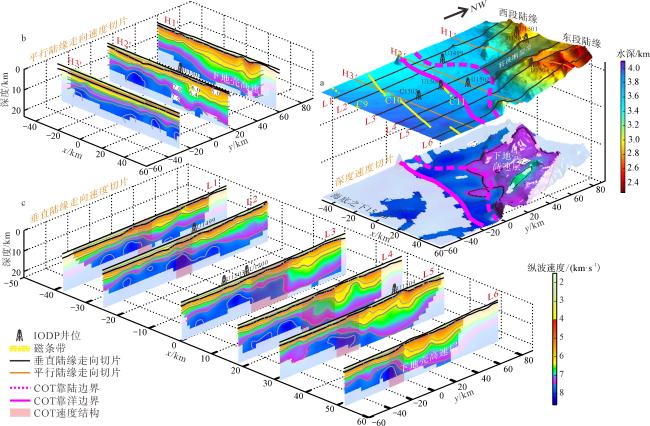
图2 三维纵波速度结构模型的垂向和深度切片[据Zhang等(2023)修改]a. 展示了海底、速度切片位置和海底以下15km的速度切片; b. 展示了3条平行陆缘走向的速度切片; c. 展示了平行伸展方向的速度切片。H1′~H3′表示平行陆缘走向速度切片, L1~L6表示垂直陆缘走向速度切片。三维纵波速度结构模型显示研究区北东、南西侧的地壳结构及其下地壳高速体分布存在显著差异 Fig. 2 Vertical and depth slices in 3D Vp model. (a) The upper right image shows the seafloor, the location of the vertical slices, and the depth slice at 15 km below the seafloor; (b) The upper left image shows three vertical slices parallel to the strike of continental margin; (c) The lower image shows the vertical slices parallel to margin extension directions. The pink areas in the slices indicate the distribution of the high velocity layer in lower crust. The 3D Vp model shows that there are significant differences in the crustal structure and the distribution of the high velocity layer in lower crust in the northeast and southwest segments of study area |
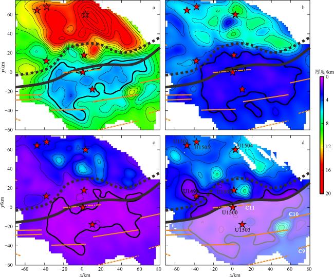
图3 南海北部陆缘洋陆转换带空间展布及不同地层的厚度图[据Zhang等(2023)修改]a. 全地壳厚度; b. 上地壳厚度; c. 下地壳厚度; d. 高速层厚度。红色五角星表示IODP井位; 粗黑色虚线表示COT的靠陆边界; 粗黑色曲线表示COT的靠洋边界; a~d的细黑色曲线分别表示5km、3km、1km和2km的厚度等值线; 灰色曲线表示其他厚度等值线; 橙色点实线、实线和虚线分别表示磁异常条带C11、C10和C9。a~d中白色不规则部分表示没有数据约束的区域 Fig. 3 Scope of Continent-Ocean Transition domain in the northeastern continental margin of the South China Sea and the thickness maps for different layers, including (a) whole crust, (b) upper crust, (c) lower crust, and (d) high-velocity layer |
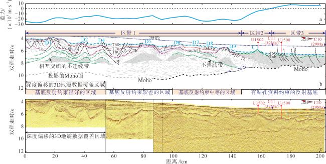
图4 L1573地震反射剖面中岩浆活动信息[据Zhang等(2021)修改]a. 自由重力异常显示在圆隆部位出现重力高的特征。b. 地震剖面解释, 依据基底反射的分辨率, 将研究区划分出约束程度很好、中等、较差和钻孔约束的4个区域; 岩盖均分布在不连续带显著发育的区带1基底中, 且造成基底顶面和同裂陷期沉积层序的抬升, D1~D9代表岩盖在沉积层中形成的圆隆; C1代表火山锥; T60~T80表示盆地内沉积填充序列的不整合面; Tb表示基底顶部界面; Tnb表示新基底顶部界面; 细黑色短虚线表示Moho面; 蓝色虚线表示海底; 绿色粗虚线表示不连续带; 图b下面长虚线的不同颜色和形状分别表示T60\T70\T80\Tb界面; 箭头表示不连续带; C11和C10表示磁异常条带; 红色实线和虚线箭头表示不同的IODP井位。c. 原始地震剖面, 剖面位置见 Fig. 4 The magmatism in multi-channel seismic reflection profile L1573. (a) Lateral variation of free air gravity anomalies shows high values in the area of dome-shaped high; (b) Line drawing and interpretation of seismic profile L1573. In terms of the data quality associated with the seismic basement the section was subdivided into four domains: well constrained, badly and moderately well constrained, and drill hole constrained. The laccolith distributed in the basement of zone 1, where the discontinuity zone is significantly developed, and caused the uplift of the top basement and syn-rift sedimentation, D1 to D9 represent dome-shaped highs formed by laccolith in sedimentary layer. C1 represents cone-shaped high; (c) For original seismic profile, see location in |
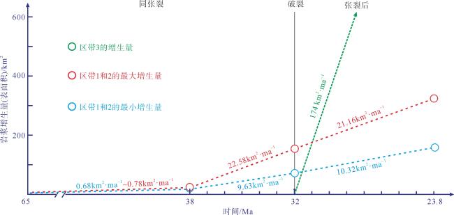
图5 岩浆量在陆缘伸展过程中的变化[据Zhang等(2021)修改]计算L1573地震剖面中岩浆量随伸展过程的变化, 红色数值代表在某一阶段最大增生的岩浆量, 蓝色数值代表最小增生量, 红色和蓝色虚线分别代表区带1和2的最大和最小增生量随时间的变化, 绿色虚线代表洋壳增生量随时间的变化, 以30km·ma-1的半扩张速率(Li et al, 2014)和5.8km的洋壳平均厚度为基础, 区带1~3范围详见 Fig. 5 The variation of magmatic amount during the rifting in SCS margin. The variation of magmatic amount versus extensional process in L1573. The red and blue circles show the estimates of maximum and minimum amount of magmatic additions. The green dashed line and related value represent the rate of production of the oceanic crust, referring to the half spreading rate of 30 km·ma-1 (Li et al, 2014) and an average thickness of 5.8 km |
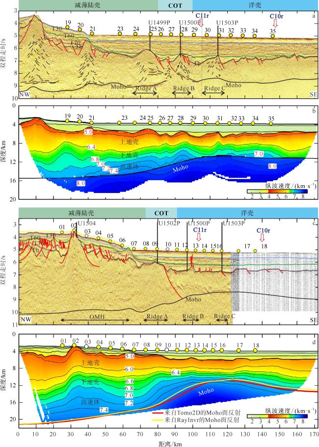
图6 沿L2和L5测线的速度结构剖面及洋陆转换带划分[据Yuan等(2023)、Wang等(2023)修改]a. 沿L2多道反射结构剖面; b. 沿L2测线反演深部速度结构; c. 沿L5测线多道反射结构剖面; d. 沿L5测线反演深部速度结构。RidgeA、RidgeB和RidgeC对应于3个基底隆起。L2和L5测线位置见 Fig. 6 The velocity profiles and COT along L2 and L5. (a) Multi-channel seismic profile along L2; (b) Inverted velocity model along L2; (c) Multi-channel seismic profile along L5; (d) Inverted velocity model along L5. Ridges A, B and C correspond to three basement highs, see locations of L2 and L5 in |
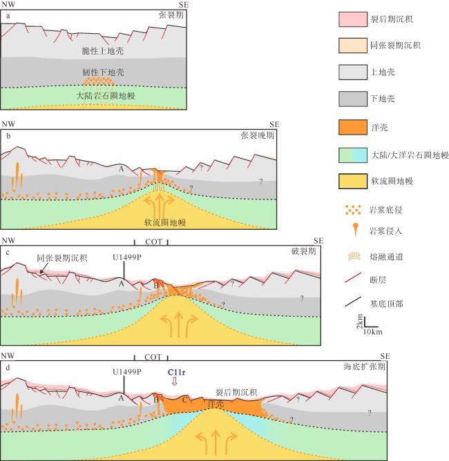
图7 南海北部陆缘张裂-破裂地质演化模式[据Yuan等(2023)修改]a. 张裂期: 岩浆底侵至下地壳从而形成下地壳高速层; b. 张裂晚期: 岩浆侵入到地壳内部从而形成数个基底隆起; c. 破裂期: 岩浆上涌迫使地壳抬升并最终破裂; d. 海底扩张期: 构造作用减弱, 海底扩张逐渐稳定。A, B, C表示基底隆起; ?表示该界面或者结构形态存在不确定性 Fig. 7 A rift-breakup geological evolution model of the northern margin of the SCS. (a) Rifting: magma underplating to form HVL; (b) Late rifting: magma intrusion to form several basement highs; (c) Breakup: abundant magma came up, uplifted the hyper-thinned continental crust and finally broke up; (d) Seafloor spreading: tectonism decreased and seafloor spreading gradually stabilized |
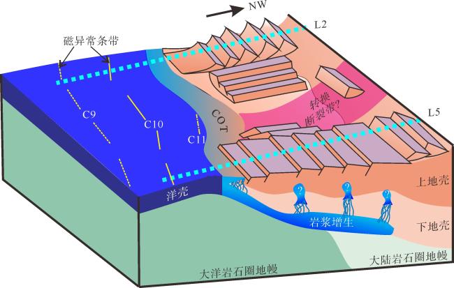
图8 南海陆缘张裂-破裂的三维地质模型[据Zhang等(2023)修改]研究区东、西两侧陆缘呈现不同的构造减薄和岩浆样式。L2和L5测线位置见 Fig. 8 Schematic diagram showing the 3D geological model of the along-strike variations in tectonism and magmatism during rift-to-drift process in the study area of SCS. See |
| [1] |
郝天珧, 游庆瑜, 2011. 国产海底地震仪研制现状及其在海底结构探测中的应用[J]. 地球物理学报, 54(12): 3352-3361.
|
| [2] |
苏晓康, 赵明辉, 李子正, 等, 2021. 南海北部陆缘OBS2018-H2测线地壳结构初步结果[J]. 热带海洋学报, 40(5): 111-122.
|
| [3] |
汪品先, 2009. 南海——我国深海研究的突破口[J]. 热带海洋学报, 28(3): 1-4.
|
| [4] |
汪品先, 2012. 追踪边缘海的生命史: “南海深部计划”的科学目标[J]. 科学通报, 57(20): 1807-1826.
|
| [5] |
汪品先, 2020. 南海深部过程的探索[J]. 科技导报, 38(18): 6-20.
|
| [6] |
王强, 赵明辉, 张佳政, 等, 2018. 南海IODP367-368钻探区深地震探测的OBS站位设计分析[J]. 热带海洋学报, 37(1): 90-97.
|
| [7] |
杨富东, 张佳政, 杜峰, 等, 2020. 三维OBS探测实验中炮点和OBS位置校正新方法[J]. 地球物理学报, 63(2): 766-777.
|
| [8] |
袁野, 赵明辉, 贺恩远, 等, 2021. 张裂陆缘地壳结构特征与张裂模式[J]. 地球科学, 46(3): 801-816.
|
| [9] |
张翠梅, 孙珍, 赵明辉, 等, 2022. 南海北部陆缘结构及构造-岩浆演化[J]. 地球科学, 47(7): 2337-2353.
|
| [10] |
赵明辉, 杜峰, 王强, 等, 2018. 南海海底地震仪三维深地震探测的进展及挑战[J]. 地球科学, 43(10): 3749-3761.
|
| [11] |
赵明辉, 丘学林, 夏少红, 等, 2008. 大容量气枪震源及其波形特征[J]. 地球物理学报, 51(2): 558-565.
|
| [12] |
|
| [13] |
|
| [14] |
|
| [15] |
|
| [16] |
|
| [17] |
|
| [18] |
|
| [19] |
|
| [20] |
|
| [21] |
|
| [22] |
|
| [23] |
|
| [24] |
|
| [25] |
|
/
| 〈 |
|
〉 |
