
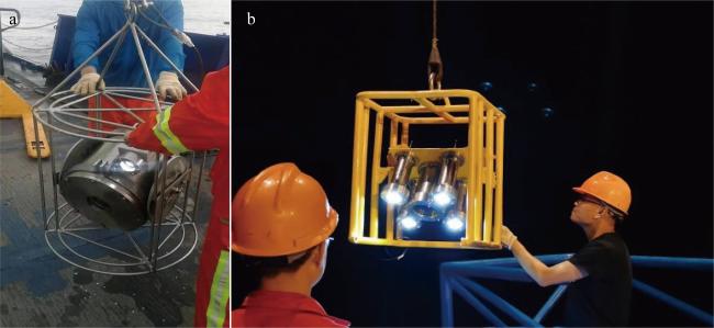
东沙群岛海区海底泥火山上拍摄到深水生物——自主研发的水下相机试验取得重要发现*
*本研究的实验、数据及样品采集得到国家自然科学基金委员会共享航次计划项目(项目批准号: 41949906、42049906)的资助。这些航次(航次编号: NORC2020-06, NORC2021-06)由 “嘉庚”号科考船实施, 在此一并致谢。
|
靳永斌(1976—), 河南省新乡市人, 副研究员, 博士, 从事地球化学研究和水下设备研发。email: jingeyb@qq.com |
Editor: 林强
收稿日期: 2024-01-30
修回日期: 2024-03-06
网络出版日期: 2024-03-14
基金资助
南方海洋科学与工程广东省实验室(广州)-广东特支计划(2019BT02H594)
国家自然科学基金(U1901217)
国家自然科学基金(41773039)
国家自然科学基金(41876052)
广东省基础与应用基础研究基金(2021A1515011298)
国家重点研发计划(2021YFF0501202)
Deep-water faunas photographed on submarine mud volcanoes in the Dongsha Islands area——important discoveries in the tests of newly developed underwater cameras
Editor: LIN Qiang
Received date: 2024-01-30
Revised date: 2024-03-06
Online published: 2024-03-14
Supported by
Special Support Program for Cultivating Highlevel Talents in Guangdong Province of Southern Marine Science and Engineering Guangdong Laboratory (Guangzhou)(2019BT02H594)
National Natural Science Foundation of China(U1901217)
National Natural Science Foundation of China(41773039)
National Natural Science Foundation of China(41876052)
Guangdong Basic and Applied Basic Research Foundation(2021A1515011298)
National Key R&D Program of China(2021YFF0501202)
靳永斌 , 阎贫 , 王彦林 , 李鹏春 . 东沙群岛海区海底泥火山上拍摄到深水生物——自主研发的水下相机试验取得重要发现*[J]. 热带海洋学报, 2024 , 43(6) : 201 -203 . DOI: 10.11978/2024033
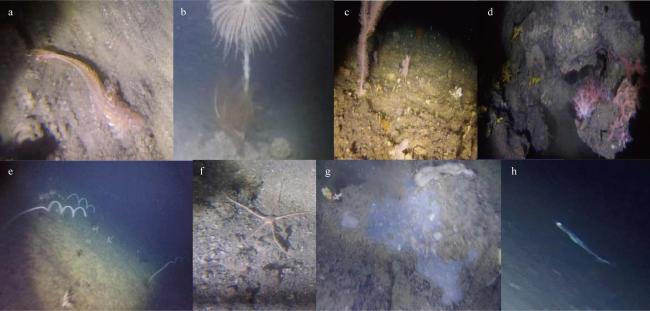
On the geophysics-imaged mud volcanoes over the northwest Dongsha Waters, a large number of deep-water benthic living organisms, fossils, and authigenic carbonate nodules were photographed by our newly developed portable underwater camera on 250-350 m deep seafloor. The organisms comprise abundant deep-water corals, glass sponge, sea anemone, sea lily, fish, shrimp, lobster and bivalve. The photographs further revealed that active methane leakage and mud volcanic activity in the Dongsha Islands area.
图2 东沙岛西北部采样点位置示意图黄色点位: 航次号NORC2020-06; 红色点位: 航次号NORC2021-06。底图引自杨胜雄 等(2015), 审图号JS(2015)02-107 Fig. 2 Schematic diagram of the sampling sites in the northwest of the Dongsha Island. Yellow points: voyage number NORC2020-06; red points: voyage number NORC2021-06 |
图3 东沙水域海底拍摄到的多种生物a. 鱼类; b. 海百合; c. 海百合; d. 海葵; e. 珊瑚; f. 海蛇尾; g. 珊瑚、海绵及未知生物; h. 鱼类 Fig. 3 Various faunas photographed on the seabed of the Dongsha Island area. (a) Fish; (b) crinoids; (c) crinoids; (d) sea anemones; (e) corals; (f) brittle stars; (g) corals, sponges and unknown organisms; (h) fish |
| [1] |
杨胜雄, 邱燕, 朱本铎, 等, 2015. 南海地质地球物理图系[M]. 天津: 中国航海图书出版社.
|
| [2] |
|
| [3] |
|
| [4] |
|
| [5] |
|
/
| 〈 |
|
〉 |

