综述

东印度洋深层环流和水团变异研究进展*

  • 梁湛林 , 1, 2 ,
  • 王卫强 , 1, 2
展开
  • 1热带海洋环境与岛礁生态全国重点实验室(中国科学院南海海洋研究所), 广东 广州 511458
  • 2广东省海洋遥感与大数据重点实验室(中国科学院南海海洋研究所), 广东 广州 510301
王卫强。email:

*本研究的数据及样品采集得到国家自然科学基金共享航次计划项目(项目批准号: 42249910、42149910)的资助, 该航次(航次编号NORC2023-10+NORC2023-303和NORC2022-10+NORC2022-303)由中国科学院南海海洋研究所“实验6”号科考船实施, 在此一并致谢。感谢美国国家海洋和大气管理局提供的WOA23 (World Ocean Atlas 2023)数据支撑, 感谢绘制地形图所使用的GMT软件(Wessel et al, 2019)

梁湛林(1992—), 男, 助理研究员, 从事东印度洋深层环流研究。email:

Editor: 孙翠慈

收稿日期: 2025-01-28

  修回日期: 2025-03-03

  网络出版日期: 2025-03-25

基金资助

中国科学院海外科教合作中心部署项目(133244KYSB20200024)

国家重点研发计划项目(2022YFE0203500)

广东省科技计划项目(2022B1212050003)

中国科学院国际伙伴计划项目(059GJHZ2023104MI)

中国科学院南海海洋研究所自主部署项目(SCSIO202201)

中国科学院南海海洋研究所自主部署项目(SCSIO2023HC07)

国家自然科学基金共享航次计划项目(42249910)

国家自然科学基金共享航次计划项目(42149910)

Research progress on the characteristics of deep-sea circulation and water masses in the deep Eastern Indian Ocean*

  • LIANG Zhanlin , 1, 2 ,
  • WANG Weiqiang , 1, 2
Expand
  • 1State Key Laboratory of Tropical Oceanography, South China Sea Institute of Oceanology, Chinese Academy of Sciences, Guangzhou 511458, China
  • 2Guangdong Key Lab of Ocean Remote Sensing and Big Data (LORS), South China Sea Institute of Oceanology, Chinese Academy of Sciences, Guangzhou 510301, China
WANG Weiqiang. email:

Editor: SUN Cuici

Received date: 2025-01-28

  Revised date: 2025-03-03

  Online published: 2025-03-25

Supported by

Project Deployment for the Overseas Science and Education Cooperation Center of the Chinese Academy of Sciences(133244KYSB20200024)

National Key Research and Development Program of China(2022YFE0203500)

Science and Technology Planning Project of Guangdong Province, China(2022B1212050003)

International Partnership Program of Chinese Academy of Sciences(059GJHZ2023104MI)

Development Fund of South China Sea Institute of Oceanology of the Chinese Academy of Sciences(SCSIO202201)

Development Fund of South China Sea Institute of Oceanology of the Chinese Academy of Sciences(SCSIO2023HC07)

Shiptime Sharing Project of National Natural Science Foundation of China (NSFC)(42249910)

Shiptime Sharing Project of National Natural Science Foundation of China (NSFC)(42149910)

摘要

东印度洋深海是全球深海系统的重要组成部分, 在全球碳循环、热量分配和营养物质运输中具有重要作用。东印度洋深海被90°E海岭分成中印度洋海盆和西澳大利亚海盆, 两个海盆间的水团特性和环流具有显著差异。为了进一步深入理解东印度洋的深海环流及水团特征, 本文通过回顾现有的研究成果, 总结和阐述了: 1)东印度洋深海地形的特殊性; 2)深海水团的来源和路径; 3)深层经向翻转环流; 4)中印度洋海盆和西澳大利亚海盆之间深层水的差异和联系。最后, 本文提出了未来东印度洋深海研究中需要重点关注的科学问题, 旨在为该领域的进一步研究提供参考。

关键词: 东印度洋; 深海; 环流; 水团

本文引用格式

梁湛林 , 王卫强 . 东印度洋深层环流和水团变异研究进展*[J]. 热带海洋学报, 2026 , 45(1) : 17 -26 . DOI: 10.11978/2025034

Abstract

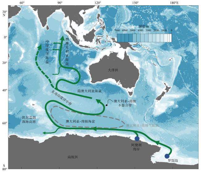
The deep water of the Eastern Indian Ocean is a crucial component of the global deep-sea system, playing a significant role in the global carbon cycle and the distribution of heat and nutrients. It is divided by the Ninety East Ridge into the Central Indian Basin (CIB) and the West Australian Basin (WAB). These two basins exhibit distinct differences in their water mass characteristics and circulation patterns. To further understand the deep-sea circulation and water mass features in the Eastern Indian Ocean, this paper reviews existing research findings and summarizes the following aspects: 1) the unique topography of the deep Eastern Indian Ocean; 2) the sources and pathways of deep-sea water masses; 3) the deep meridional overturning circulation; and 4) the differences and connections between the deep-sea water masses in the CIB and the WAB. Finally, this paper highlights key scientific issues that need to be addressed in future research on the deep sea of the Eastern Indian Ocean, providing a reference for related studies.

在过去的几十年里, 先进的卫星高度计和多种海洋观测仪器技术发展迅速, 然而人类对全球大洋深海(2000米以深)的认知仍然有限(Lagerloef et al, 1999; Johnson et al, 2002; Sudre et al, 2008)。尽管深海对大多数生物而言是恶劣的生存环境, 但它在全球气候变化中扮演着重要而独特的角色。深海能够吸收来自地表的二氧化碳, 从而有助于缓解温室效应(Levin et al, 2015; Zika et al, 2015); 同时, 深海也储存了全球变暖产生的大部分热量, 进而对海平面上升起到调节作用(Purkey et al, 2012; Cheng et al, 2017)。此外, 深海环流所携带的温度、盐度、营养盐、溶解氧等水团性质, 在全球碳循环、热量和营养物质的分配中具有至关重要的调节作用(Stramma et al, 2010)。因此, 深入研究深海环境具有重要的科学意义。
东印度洋深海是全球深海的重要组成部分, 对海洋热量和淡水输运同样具有显著的贡献(Schott et al, 2001)。根据斯托梅尔理论提出的大洋深层环流框架(Stommel, 1958), 大洋环流输运在西印度洋的深层西边界流沿着马达加斯加岛以东的深渊向北流动, 并在印度洋北部上升(Toggweiler et al, 1995; Speich et al, 2001)。相比较而言, 尽管Warren在1977年首次提出东印度洋的西澳大利亚海盆存在深层西边界流(Warren, 1977), 但东印度洋的深层环流的研究仍相对有限。作为印度洋最大的腹地, 东印度洋不仅拥有全球著名的90°E海岭, 其水团变化和环流运动对全球大尺度环流和气候系统也具有重要影响。因此, 为了更好地理解东印度洋深层环流和水团的基本特征, 本文对现有的东印度洋深海相关研究成果进行系统性回顾和总结, 为进一步深入认识东印度洋深层环流、水团变化、地质特征以及生物活动等现象提供参考。

1 东印度洋深海的地形特征

东印度洋深海地形复杂且几乎封闭。东印度洋深海主要由3000m以深的地形构成, 是一个几乎封闭的海盆, 其经纬度范围是65°E—121°E, 35°S—21°N (图1)。东印度洋深海的东边界由印尼群岛陆架以及大洋洲陆架组成, 北接亚洲大陆, 西边被查戈斯-拉克代夫海岭(Chagos-Laccadive Ridge)和中印度洋中脊(Central Indian Ridge)阻隔, 南边界由东南印度洋中脊(Southeast Indian Ridge)、布罗肯海脊(Broken Ridge)和博物学家深海高原(Naturaliste Plateau)组成(Talley et al, 2011; Levchenko et al, 2014)。从地形上看, 东印度洋深海海盆与邻近深海进行物质交换的通道主要有3个, 即位于西边的查戈斯-拉克代夫海岭和中印度洋中脊之间的西侧通道, 东南印度洋中脊和布罗肯海脊之间的西南通道, 以及布罗肯海岭和博物学家深海高原之间的东南通道。其中, 东印度洋西侧的深海通道与阿拉伯海盆(Arabian Basin)连接, 南侧的两个深海通道则与南澳大利亚海盆(South Australian Basin)相连。
图1 东印度洋深海的地形特征

Fig. 1 Bathymetric features of the deep Eastern Indian Ocean (EIO)

东印度洋海盆的深度总体从南向北逐渐递减, 深渊区主要集中在25°S至赤道之间。由于东印度洋深海的西侧几乎被印度洋中脊包围, 因此其西侧通道和西南通道受此影响较浅, 深度约为3600m (Smith et al, 1997)。东南通道则相对较深, 可达6500m (Sloyan, 2006), 是东印度洋与南极底层水交换的主要通道。在深渊区, 海盆的腹地分布着众多南北向的海沟, 其深度可达7000m左右。东印度洋深海的东北部, 存在安德曼海沟(Anderson Trench)和爪哇海沟(Java Trench), 其最大深度达到7450m (Stewart et al, 2019)。
90°E海岭是东印度洋深海独特的海盆特征。在东印度洋中央, 存在一个全球最长、与90°E经线近似平行的直线型海岭, 即90°E海岭。该海岭是凯尔盖朗热点(Kerguelen hotspot)、印度洋板块扩张与洋中脊共同作用的产物。在早始新世, 凯尔盖朗热点通过地幔柱产生火山岩(朱佳豪 等, 2024), 而印度洋板块向北扩张将这些火山岩展布后, 逐渐形成海岭的空间形态(Ludden et al, 1980; Frey et al, 2011; Krishna et al, 2012)。90°E海岭的经向跨度34°S17°N, 南连布罗肯海岭, 北至安达曼弧(Andaman arc), 总长跨度约5500km (Bowin, 1973; Frey et al, 1995; Michael et al, 2011), 宽度150~250km (Lemenkova, 2021), 距离海平面的深度约为2000~3000m。90°E海岭将东印度洋深海一分为二: 东侧为西澳大利亚海盆(West Australian Basin, WAB), 西侧则为中印度洋海盆(Central Indian Basin, CIB) (Carpenter et al, 1973; Warren, 1982; Warren et al, 2002; Aderhold et al, 2016; Stevens et al, 2020)。

2 东印度洋深层水团的来源和路径

东印度洋北部缺乏深层水和底层水的生成机制, 因此其深层水主要来源于南极(Schmitz, 1995, 1996), 即南极底层水(Antarctic bottom water, AABW)和下层绕极深层水(lower circumpolar deep water, LCDW), 但这些水团北上的路径由于受到复杂地形的影响而变得复杂。如图2所示, AABW主要在南大洋的罗斯海(Ross Sea)和阿黛利海岸(Adelie Coast)附近生成(Orsi et al, 1995; Johnson, 2008), 随后沿南极洲陆坡向西流动(Park et al, 1998; Bindoff et al, 2000; Williams et al, 2010; Solodoch et al, 2022)。在90°E附近, 携带AABW的海流分岔成两支, 一支继续向西, 另一支则沿着凯尔盖朗深海高原(Kerguelen Plateau)的东侧向北运动(Orsi et al, 1999; Donohue et al, 1999; Fukamachi et al, 2010; Silvano et al, 2023)。这支北向流抵达东南印度洋中脊的南侧之后, 又折向东沿着洋脊流动(Reid, 2003)。在上述过程中, AABW不断地与密度相对较低一些的LCDW相混合(Sloyan et al, 2001; Sloyan, 2006)。当AABW和LCDW经过125°E附近的澳大利亚-南极不整合带(Australia-Antarctica discordance)时, 一部分继续向东流动, 形成深层澳大利亚-南极气旋涡(McCartney et al, 2007; Gunn et al, 2023); 另一部分则向北穿过这些不整合带, 进入南澳大利亚海盆(Rodman et al, 1982; Palmer et al, 1993; Hufford et al, 1997; Donohue et al, 1999; Reid, 2003; McCartney et al, 2007)。此后, AABW和LCDW沿着东南印度洋中脊的北侧继续向北流动。当经过东印度洋深海的西南通道时, 一部分AABW和LCDW向北进入到中印度洋海盆(Reid, 2003); 其余则继续沿着布罗肯海岭南侧向东流动, 在经过东南通道的西侧时, 向北进入珀斯海盆(Perth Basin) (Toole et al, 1993; Talley et al, 1997)。值得注意的是, 由于洋脊海岭的阻隔, 西印度洋与东印度洋之间的深渊水并无充分的交流(Mantyla et al, 1995; Reid, 2003)。
图2 东印度洋深层水来源示意图

Fig. 2 Schematic diagram of the sources and pathways of bottom water in the EIO

东印度洋深层水的流动路径主要沿深海海盆的西边界分布, 并在海盆间存在交换。在中印度洋海盆, 尽管西南通道存在北向的输运通量(Srinivasan et al, 2009), 但无直接观测表明AABW和LCDW沿着东南印度洋中脊和中印度洋中脊向北流动(Warren, 1977, 1982; Reid, 2003; Drijfhout et al, 2008)。在经过西侧通道时, AABW和LCDW可能通过查戈斯-克代夫海岭和中印度洋中脊之间的狭长通道, 与阿拉伯海深海水相连接(Fischer et al, 1982; You, 2000)。在西澳大利亚海盆, AABW和LCDW穿越珀斯海盆北边的East Indiaman海岭后, 向西流动至90°E海岭的东侧(Warren et al, 2002)。随后, 大部分水团沿着90°E海岭向北流动(Warren, 1977, 1982), 成为孟加拉湾的深层水(You, 2000); 少部分则向南流动, 到达布罗肯海岭北侧(Toole et al, 1993; McCartney et al, 2007)。中印度洋海盆深层水团不仅可通过西南通道, 还可通过90°E海岭上的缺口。这些缺口由地质构造过程的不连续性造成, 在一定程度上打破了西澳大利亚海盆和中印度洋海盆的封闭性(Warren, 1982; Toole et al, 1993; Mantyla et al, 1995; Warren et al, 2002)。上述深层水进入东印度洋, 逐渐升温并上升, 形成高温、高盐、低溶解氧和低营养盐浓度的印度洋深层水(Schmitz, 1995; Talley et al, 2011)。印度洋深层水向南返回, 并最终沿着珀斯海盆的东边界流出东印度洋(Toole et al, 1993; Sloyan, 2006), 随后其主要沿着澳大利亚南边界地形流入太平洋(Tamsitt et al, 2019)。目前, 关于东印度洋深层水的流动路径还未完全确定(Warren, 1977; Rodman et al, 1982; Warren et al, 2002)。

3 东印度洋深层经向翻转环流

印度洋深层经向翻转环流(meridional overturning circulation, MOC)是研究全球大洋热量和营养盐输运的重要组成部分。尽管已有不少相关研究, 但其强度和通量仍存在较大的不确定性。早在20世纪30年代, Clowes 等(1935)利用航次的水文剖面数据, 首次发现印度洋西边的北向深层环流以及上层的南向回流。此后, 由于深层经向翻转环流的强度对全球大洋热量和营养盐输运至关重要, 针对印度洋深层经向翻转环流输运通量的研究层出不穷。前人研究表明, 就整个印度洋深海而言, 深层经向翻转环流的净通量大小7~22Sv (Robbins et al, 1997; Macdonald, 1998; Ganachaud et al, 2000; Lumpkin et al, 2007; Aderhold et al, 2016)。Wang 等(2012)基于GECCO(German contribution of the Estimating the Circulation and Climate of the Ocean project)模式资料, 计算出3200m以下的向北输运通量为2.1Sv(1Sv=106m3·s−1)。Hernández-Guerra 等(2016)则指出, 印度洋深层经向输运通量在年际尺度上呈现减弱趋势(从2002年的11Sv减弱到2009年的7Sv)。
东南通道是东印度洋深层经向翻转环流的重要路径, 其深层水团的输运通量在前人研究中获得大量关注, 但结果仍存在一定的差异和不确定性。利用海洋观测资料估算, 东印度洋深层经向翻转环流在深层(2000m以下)具有6.7Sv的北向净输运通量, 在底层(3500m以深)则为2.3Sv (Kouketsu et al, 2011)。利用热成风理论, Toole 等(1993)提出东南通道2000m以下的北向净输运通量为6.1Sv。其中, 通道西侧为7.1Sv的北向输运, 东侧为1Sv的南向输运。而Talley 等(1997)估计的净通量大小为5.2Sv, 包括通道西侧6.6Sv的北向输运和东侧1.4Sv的南向输运。随后的研究则进一步给出了东南通道输运通量的误差范围。Ganachaud 等(2000)指出东南通道2000m以下的净北向输送量为(1±8)Sv, Sloyan 等(2001)则认为净通量为(7±2)Sv, 包括(8.3±2)Sv的北向输运和(1.3±1)Sv南向输运。Sloyan (2006)根据海流计的长时间观测结果, 估算出东南通道3200m以下的净向北输运通量在4.4~5.8Sv, 其中, AABW的输运通量在2~2.5Sv。Srinivasan 等(2009)利用HYCOM (hybrid coordinate ocean model)再分析资料, 计算出东南通道3500m以下的输运通量为(7±8)Sv。
相比于东南通道, 西南通道的深层水输运通量研究相对较少。由于水深相对较浅, 西南通道的输运通量估计为(2±6)Sv (Srinivasan et al, 2009)。在东印度洋深海内部, Srinivasan 等(2009)利用HYCOM模式计算得出, 中印度洋海盆在20°S断面的深层(2000~3500m)和底层(3500m以下)的输运通量分别为(15±10)、(4±7)Sv, 而西澳大利亚海盆的输运通量则分别为(−6±11)、(4±11)Sv。Warren (1982)利用站位资料, 估算中印度洋海盆内部(12°S)在2000~3800m存在3Sv的北向深层西边界流。本文利用同样在20°S断面的世界大洋环流试验(World Ocean Circulation Experiment, WOCE I03)水文观测资料, 计算得到中印度洋海盆地转流输运通量为−0.36Sv, 西澳大利亚海盆则为5.29Sv。这表明, 西澳大利亚海盆的深层经向翻转环流更强。
印度洋深层经向翻转环流的动力结构和时空变化复杂, 受到埃克曼(Ekman)输运、地转输运以及季风和印度洋偶极子(Indian Ocean Dipole, IOD)等多因素的共同影响。印度洋经向翻转环流的动力分解结果表明, Ekman部分在南印度洋呈现逆时针翻转结构, 其强度在10°S达到最大; 地转和外模部分则在10°S以南分别呈现相似的顺时针和逆时针的翻转结构, 但在27°S强度最大且符号相反。相比较而言, 在20°S至赤道之间的区域, Ekman部分对MOC的影响更明显; 而地转及外模部分的贡献则在25°S以南的区域更明显(黄旭媚 等, 2016)。在季节变化方面, 印度洋的深层经向翻转环流主要受到季风调控的Ekman部分控制: 夏季以20°S为分界线, 在其南侧呈现逆时针的翻转环流结构, 北侧为顺时针环流结构; 冬季则相反(Lee et al, 1998; Wang et al, 2012)。在年际变化方面, 印度洋深层经向翻转环流主要呈现为两年的振荡周期(Wang et al, 2012), 并且与IOD紧密相关(Wang et al, 2014)。在IOD的发展时期, Ekman部分调控经向深层翻转环流的结构。而在IOD的成熟期和衰退时期, 地转部分起主导作用, 导致赤道以南(北)出现逆(顺)时针的翻转环流结构; Ekman部分在10°S以南同样有着重要作用, 但其在10°S与赤道之间对逆时针的翻转环流结果起抑制作用。由于水文观测数据的低时空分辨率较低以及数值模式结果的差异性, 目前对于印度洋深层经向翻转环流的研究还远远不够, 尤其是在复杂地形下东印度洋的深层环流结构方面。

4 东印度洋深层海盆间的差异和联系

AABW水团特性在输运过程中存在变异, 导致中印度洋海盆与西澳大利亚海盆深层水团之间的差异。AABW水团具有超低温、低盐和高溶解氧的特性(Rodman et al, 1982)。尽管AABW是东印度洋深层水的主要来源, 但其运输过程中, 水团特性的变化使得中印度洋海盆与西澳大利亚海盆的深层水团呈现出不同特征。这种水团特征的差异首先出现在东印度洋深海的南边界。在2002年和2009年32°S断面的水文观测剖面中, 均可发现从西南通道进入中印度洋海盆的水团温度在1℃以上, 盐度在3300m以浅较高(34.73‰以上)、3300m以深较低, 溶解氧浓度高于200μmol·kg−1, 硅酸盐浓度低于120μmol·kg−1。相比之下, 在东南通道上的水团温度在3500m以浅高于1℃、3500m以深较低, 硅酸盐浓度高于120μmol·kg−1, 溶解氧略高, 盐度与西南通道处接近(McDonagh et al, 2008; Hernández-Guerra et al, 2016)。
中印度洋海盆与西澳大利亚海盆的深层水团特性的差异与90°E海岭的屏障作用有关。在海盆内部, Warren (1982)基于航次水文观测资料首次指出, 中印度洋海盆2000~3800m之间的水团, 具有高溶解氧浓度、低盐度以及低溶解硅、磷酸盐和硝酸盐浓度的特征。在空间分布上, 由于AABW和LCDW的北向入侵, 中印度洋海盆西部温度为1.5~2.5℃的水团表现出更低的盐度、更高溶解氧和硅酸盐浓度的特征。然而, 这些水团特性在中印度洋海盆内部逐渐减弱, 这可能与东部的南向回流有关。中印度洋海盆深海水团在西南通道的温度约为0.94℃, 最低温度位于海岭10°S缺口附近, 可达0.8~0.9℃ (McCartney et al, 2007)。在西澳大利亚海盆, AABW和LCDW从珀斯海盆进入后, 最低温度有所上升, 从0.6℃提升到0.6~0.7℃(McCartney et al, 2007)。You (2000)利用众多历史观测资料, 发现西澳大利亚海盆的深层水团具有较低的温度和盐度以及较高的磷酸盐浓度, 而溶解氧在中印度洋海盆北部更低(Ye et al, 2023)。本文利用WOA23数据集, 分析了两个海盆平均的深层水团特性差异在深度上的变化。如图3所示, 在2000~3000m层, 两个海盆的温度基本一致, 西澳大利亚海盆的盐度和溶解氧较低、硅浓度较高。然而, 在3000m至海底, 西澳大利亚海盆总体具有更低的温度、盐度和硅酸盐浓度, 以及更高的溶解氧浓度。这种海盆间的水团差异随水深增加而增大。
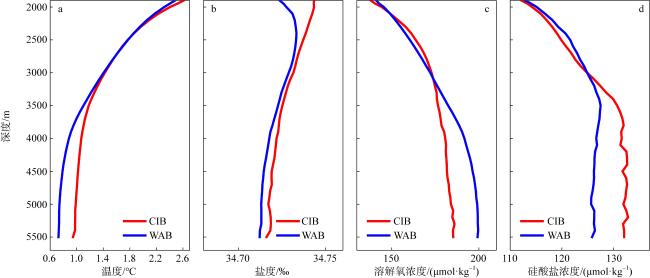
图3 海盆平均后位势温度(a)、盐度(b)、溶解氧浓度(c)和硅酸盐浓度(d)的垂向变化。红线代表中印度洋海盆(CIB), 蓝线代表西澳大利亚海盆(WAB)

Fig. 3 Vertical variations of basin-averaged WOA23 temperature (a), salinity (b), dissolved oxygen (c), and silicate concentrations (d) over Central Indian Basin (red line) and West Australian Basin (blue line)
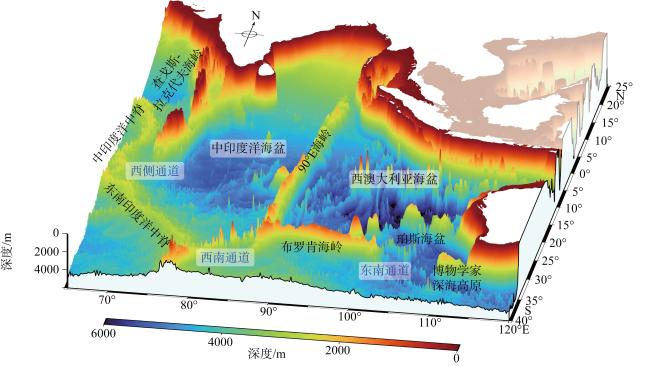
尽管90°E海岭的地形阻挡导致了海盆之间的水团特性的差异, 其上的深海缺口却成为水团交换的关键通道, 对东印度洋深层水动力过程和环流结构产生重要影响。早期的研究认为90°E海岭的缺口主要有4个, 分别分布在3°S、5°S、10°S以及28°S附近(图4)。利用90°E海岭西侧的水文观测资料, Warren (1982)首先指出, 在10°S缺口的西侧附近, 水团在4300m深处表现出低温和高溶解氧的特征, 并估算出此缺口的输运通量为0.4Sv。这为西澳大利亚深层水的向西进入中印度洋海盆的猜想提供了事实证据。另外, Warren (1982)认为10°S缺口的深层水向西向流动与丹麦海峡“深海瀑布”类似, 在中印度洋海盆形成纬向流后, 驱动中印度洋海盆底层(3800m以深)的环流结构(图5)。相较而言, 5°S缺口的“深海瀑布”更弱(输运通量为0.1Sv), 3°S缺口则无此西向流动。根据世界大洋环流试验的水文观测资料, Warren 等(2002)估算出5°S和10°S缺口的水体交换强度相当, 分别为1.0Sv和1.1Sv。28°S缺口是90°E海岭南北横截面最大的缺口(Silva et al, 2013)。Toole 等(1993)根据中印度洋海盆东南部的异常冷底层水, 推断此处同样存在西向的流动。McCartney 等(2007)的水文观测则进一步验证这一现象。尽管如此, 28°S缺口并不是西澳大利亚海盆和中印度洋海盆水团交换的主要通道, 因为其西向流动的通量大小仅为0.1Sv。
图4 90°E海岭地形以及其缺口示意图

Fig. 4 Bathymetric features of the Ninety East Ridge and its saddles

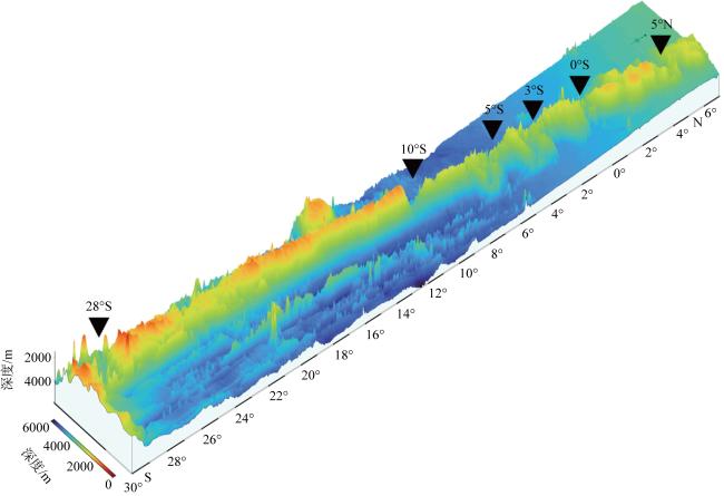
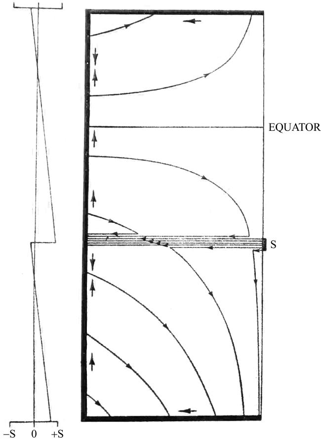
图5 10°S缺口的“深海瀑布”驱动中印度洋海盆底层环流示意图(引自Warren, 1982)

东部边界上的源S提供强迫。带箭头的细线表示内部流动的流线。粗线表示北部、南部和西部边界的海水流线, 箭头表示流动方向。流线束表示的从源点向西流动的纬向喷流。左侧表示西部边界流的体积输运随纬度的变化(正值表示向北流动), 单位为源S的强度

Fig. 5 Schematic pattern of horizontal circulation in a rectangular basin (representing the CIB) driven by upwelling at the top of the layer, as forced by a source S on the eastern boundary (Warren, 1982). Light lines with arrowheads denote streamlines of the interior flow. Heavy lines indicate the northern-, southern-, and western-boundary currents, with adjacent arrows showing flow direction. The bundle of streamlines represents the zonal jet flowing westward from the source. The left side shows the volume transport of the western-boundary current varying with latitude (positive values indicate northward flow), measured in units of source-strength S

近期的研究利用底层锚系潜标观测数据揭示了90°E海岭缺口的复杂地形对深层环流季节内信号的重要影响。Ye 等(2023)和Wang 等(2024)利用底层锚系潜标的长时间连续观测数据, 率先开展了90°E海岭缺口复杂地形深层环流观测研究, 为该领域的探索奠定了重要基础。Ye 等(2023)指出, 海岭赤道处缺口的底层流受到地形反射作用的影响, 主要表现为西南或者东南方向。底层流在夏季和冬季具有显著的季节内振荡信号(约33d), 这种季节内信号由上层印度洋东边界的西传罗斯贝波导致。另外, 通过水团分析, Ye 等(2023)认为赤道缺口的水团交换为东向, 即从中印度洋海盆流入西澳大利亚海盆。Wang 等(2024)发现5°N缺口的深层流具有剧烈的10~20d季节内信号。这些季节内信号在跨等深线方向的振幅更强, 这与在位涡守恒调整下跨深线运动所激发的地形罗斯贝波密切相关。

5 总结与展望

尽管印度洋面积小于大西洋和太平洋, 但其经向翻转环流的输运通量却不容忽视(Schmitz, 1996), 这使得对印度洋的深层环流的研究在理解全球热量分布和气候变化调节中具有重要意义。作为印度洋的主要组成部分, 东印度洋深海是一个相对封闭的深海海盆, 与外界的联系主要通过三个关键通道实现。在东印度洋中央, 全球最长的直线型海岭——90°E海岭, 将印度洋深海分成中印度洋海盆和西澳大利亚海盆。东印度洋北边缺乏底层水的生成源地, 其深层水团完全来自南极大陆架深层的AABW和LCDW。这些深层水团穿过南澳大利亚海盆之后, 通过西南通道和东南通道进入东印度洋深海。AABW和LCDW经过东南通道的西侧进入珀斯海盆后, 向西运动抵达90°E海岭的东侧, 形成西澳大利亚海盆的深层西边界流。中印度洋海盆和西澳大利亚海盆的水团在3000m开始出现显著差异。相比较于中印度洋海盆, 西澳大利亚海盆水团具有低温、低盐、低硅酸盐浓度、高溶解氧和高密度的特征。然而, 90°E海岭缺口的存在一定程度上减小了两个海盆之间的水团差异。此外, 5°S和10°S缺口处强烈的西向“深海瀑布”, 进一步增加了该区域深层环流动力过程的复杂性。
尽管东印度洋深海的研究已取得了一些进展, 但由于深海观测资料的稀缺, 人类对深海环流和水团的具体细节仍缺乏足够深入的了解。目前, 东印度洋深海的研究仍存在以下两方面亟待解决的问题。
(1)东印度洋深海环流结构与路径
1)中印度洋海盆环流研究: 由于西南通道水深较浅, AABW和LCDW的入侵仅能影响3000~3800m层的中印度洋海盆环流, 而底层(3800m以深)的环流结构需要进一步深入探讨。
2)AABW和LCDW入侵西澳大利亚海盆的具体路径: Warren 等(2002)仅依据断面的营养盐锋面, 判断AABW和LCDW在经过珀斯海峡北边的East Indiaman海岭后, 形成一支向西的纬向急流到达90°E海岭的东侧; 而You (2000)和Reid (2003)则认为底层水是沿着布罗肯海岭北侧抵达90°E海岭。因此, 西澳大利亚海盆AABW和LCDW抵达90°E海岭的具体路径尚未完全明确。
3)10°S缺口的跨海盆水体交换
与其他缺口相比, 10°S缺口虽非最深通道, 却存在活跃的跨海盆水体交换。此外, 10°S处位于南印度洋的信风区, 常年受到东南信风的影响, 该区域存在多尺度变化的海洋动力过程, 如印度洋南赤道流、中层流、印尼贯穿流及西传的罗斯贝波活动等。因此, 10°S缺口的输运通量的变异具有较高的复杂性。然而, 目前针对10°S缺口“深海瀑布”的观测资料尚显匮乏, 其时空特征以及运动路径等一系列科学问题亟待通过深层水文观测进一步加以研究。
(2)东印度洋深海生物分布和生化循环特征
由于受到季风-信风系统和90°E海岭的屏障作用的共同影响, 东印度洋的生物地球化学循环和生物多样性具有更多的复杂性和不确定性。90°E海岭地形影响下海洋多尺度动力过程如何影响生态系统的分布? 海岭的屏障作用是否造成不同的海洋生物群落通过海岭缺口? 深海环流如何驱动跨海盆生物扩散和连通机制? 这些科学问题亟待进一步揭示。
[1]
黄旭媚, 王卫强, 刘海龙, 2016. 基于多套数据的印度洋深层经向翻转环流的动力特征[J]. 热带海洋学报, 35(4): 11-20.

DOI

HUANG XUMEI, WANG WEIQIANG, LIU HAILONG, 2016. The dynamic characteristics of deep meridional overturning circulation in the Indian Ocean based on six reanalysis datasets[J]. Journal of Tropical Oceanography, 35(4): 11-20 (in Chinese with English abstract).

DOI

[2]
朱佳豪, 裴彦良, 支鹏遥, 等, 2024. 东印度洋东经90°海岭的地球物理特征和成因探讨[J]. 海洋科学进展, 42(3): 515-531.

ZHU JIAHAO, PEI YANLIANG, ZHI PENGYAO, et al, 2024. Geophysical characteristics and genesis of the Ninetyeast Ridge in the eastern Indian Ocean[J]. Advances in Marine Science, 42(3): 515-531 (in Chinese with English abstract).

[3]
ADERHOLD K, ABERCROMBIE R E, 2016. Seismotectonics of a diffuse plate boundary: Observations off the Sumatra-Andaman trench[J]. Journal of Geophysical Research: Solid Earth, 121(5): 3462-3478.

DOI

[4]
BINDOFF N L, ROSENBERG M A, WARNER M J, 2000. On the circulation and water masses over the Antarctic continental slope and rise between 80 and 150°E[J]. Deep Sea Research Part II: Topical Studies in Oceanography, 47(12-13): 2299-2326.

DOI

[5]
BOWIN C, 1973. Origin of the Ninety East Ridge from studies near the equator[J]. Journal of Geophysical Research (1896-1977), 78(26): 6029-6043.

DOI

[6]
CARPENTER G, EWING J, 1973. Crustal deformation in the Wharton Basin[J]. Journal of Geophysical Research (1896-1977), 78(5): 846-850.

DOI

[7]
CHENG LIJING, TRENBERTH K E, FASULLO J, et al, 2017. Improved estimates of ocean heat content from 1960 to 2015[J]. Science Advances, 3(3): e1601545.

[8]
CLOWES A J, DEACON G E R, 1935. The deep-water circulation of the Indian ocean[J]. Nature, 136(3450): 936-938.

DOI

[9]
DONOHUE K A, HUFFORD G E, MCCARTNEY M S, 1999. Sources and transport of the deep western boundary current east of the Kerguelen Plateau[J]. Geophysical Research Letters, 26(7): 851-854.

DOI

[10]
DRIJFHOUT S S, GARABATO A C N, 2008. The zonal dimension of the Indian ocean meridional overturning circulation[J]. Journal of Physical Oceanography, 38(2): 359-379.

DOI

[11]
FISCHER R L, JANTSCH M Z, COMER R L, 1982. General bathymetric chart of the oceans (GEBCO), map 5. 09[Z]. Ottawa: Canadian Hydrographic Service.

[12]
FREY F A, PRINGLE M, MELENEY P, et al, 2011. Diverse mantle sources for Ninetyeast Ridge magmatism: Geochemical constraints from basaltic glasses[J]. Earth and Planetary Science Letters, 303(3-4): 215-224.

DOI

[13]
FREY F A, WEIS D, 1995. Temporal evolution of the Kerguelen plume: Geochemical evidence from 38 to 82 ma lavas forming the Ninetyeast ridge[J]. Contributions to Mineralogy and Petrology, 121(1): 12-28.

DOI

[14]
FUKAMACHI Y, RINTOUL S R, CHURCH J A, et al, 2010. Strong export of Antarctic Bottom Water east of the Kerguelen plateau[J]. Nature Geoscience, 3(5): 327-331.

DOI

[15]
GANACHAUD A, WUNSCH C, MAROTZKE J, et al, 2000. Meridional overturning and large-scale circulation of the Indian Ocean[J]. Journal of Geophysical Research: Oceans, 105(C11): 26117-26134.

[16]
GUNN K L, RINTOUL S R, ENGLAND M H, et al, 2023. Recent reduced abyssal overturning and ventilation in the Australian Antarctic Basin[J]. Nature Climate Change, 13(6): 537-544.

DOI

[17]
HERNÁNDEZ-GUERRA A, TALLEY L D, 2016. Meridional overturning transports at 30°S in the Indian and Pacific Oceans in 2002-2003 and 2009[J]. Progress in Oceanography, 146: 89-120.

DOI

[18]
HUFFORD G E, MCCARTNEY M S, DONOHUE K A, 1997. Northern boundary currents and adjacent recirculations off southwestern Australia[J]. Geophysical Research Letters, 24(22): 2797-2800.

DOI

[19]
JOHNSON G C, 2008. Quantifying Antarctic bottom water and north Atlantic deep water volumes[J]. Journal of Geophysical Research: Oceans, 113(C5): 2007JC004477.

[20]
JOHNSON G C, SLOYAN B M, KESSLER W S, et al, 2002. Direct measurements of upper ocean currents and water properties across the tropical Pacific during the 1990s[J]. Progress in Oceanography, 52(1): 31-61.

DOI

[21]
KOUKETSU S, DOI T, KAWANO T, et al, 2011. Deep ocean heat content changes estimated from observation and reanalysis product and their influence on sea level change[J]. Journal of Geophysical Research: Oceans, 116(C3): C03012.

[22]
KRISHNA K S, ABRAHAM H, SAGER W W, et al, 2012. Tectonics of the Ninetyeast Ridge derived from spreading records in adjacent oceanic basins and age constraints of the ridge[J]. Journal of Geophysical Research: Solid Earth, 117(B4): 2011JB008805.

[23]
LAGERLOEF G S E, MITCHUM G T, LUKAS R B, et al, 1999. Tropical Pacific near-surface currents estimated from altimeter, wind, and drifter data[J]. Journal of Geophysical Research: Oceans, 104(C10): 23313-23326.

[24]
LEE TONG, MAROTZKE J, 1998. Seasonal cycles of meridional overturning and heat transport of the Indian ocean[J]. Journal of Physical Oceanography, 28(5): 923-943.

DOI

[25]
LEMENKOVA P, 2021. Exploring structured scripting cartographic technique of GMT for ocean seafloor modeling: A case of the East Indian Ocean[J]. Maritime Technology and Research, 3(2): 162-184.

DOI

[26]
LEVCHENKO O V, SBORSHCHIKOV I M, MARINOVA Y G, 2014. Tectonics of the Ninety-East Ridge[J]. Oceanology, 54(2): 231-244.

DOI

[27]
LEVIN L A, LE BRIS N, 2015. The deep ocean under climate change[J]. Science, 350(6262): 766-768.

DOI

[28]
LUDDEN J N, THOMPSON G, BRYAN W B, et al, 1980. The origin of lavas from the Ninetyeast Ridge, eastern Indian Ocean: an evaluation of fractional crystallization models[J]. Journal of Geophysical Research: Solid Earth, 85(B8): 4405-4420.

[29]
LUMPKIN R, SPEER K, 2007. Global ocean meridional overturning[J]. Journal of Physical Oceanography, 37(10): 2550-2562.

DOI

[30]
MACDONALD A M, 1998. The global ocean circulation: a hydrographic estimate and regional analysis[J]. Progress in Oceanography, 41(3): 281-382.

DOI

[31]
MANTYLA A W, REID J L, 1995. On the origins of deep and bottom waters of the Indian Ocean[J]. Journal of Geophysical Research: Oceans, 100(C2): 2417-2439.

[32]
MCCARTNEY M S, DONOHUE K A, 2007. A deep cyclonic gyre in the Australian-Antarctic Basin[J]. Progress in Oceanography, 75(4): 675-750.

DOI

[33]
MCDONAGH E L, BRYDEN H L, KING B A, et al, 2008. The circulation of the Indian Ocean at 32°S[J]. Progress in Oceanography, 79(1): 20-36.

DOI

[34]
MICHAEL L, KRISHNA K S, 2011. Dating of the 85°E Ridge (northeastern Indian Ocean) using marine magnetic anomalies[J]. Current Science, 100(9): 1314-1322.

[35]
ORSI A H, JOHNSON G C, BULLISTER J L, 1999. Circulation, mixing, and production of Antarctic bottom water[J]. Progress in Oceanography, 43(1): 55-109.

DOI

[36]
ORSI A H, WHITWORTH T, NOWLIN W D, 1995. On the meridional extent and fronts of the Antarctic Circumpolar Current[J]. Deep Sea Research Part I: Oceanographic Research Papers, 42(5): 641-673.

DOI

[37]
PALMER J, SEMPÉRÉ J C, CHRISTIE D M, et al, 1993. Morphology and tectonics of the Australian-Antarctic discordance between 123° E and 128° E[J]. Marine Geophysical Researches, 15(2): 121-152.

DOI

[38]
PARK Y H, CHARRIAUD E, FIEUX M, 1998. Thermohaline structure of the Antarctic surface water/winter water in the Indian sector of the Southern Ocean[J]. Journal of Marine Systems, 17(1-4): 5-23.

DOI

[39]
PURKEY S G, JOHNSON G C, 2012. Global contraction of Antarctic bottom water between the 1980s and 2000s[J]. Journal of Climate, 25(17): 5830-5844.

DOI

[40]
REID J L, 2003. On the total geostrophic circulation of the Indian Ocean: flow patterns, tracers, and transports[J]. Progress in Oceanography, 56(1): 137-186.

DOI

[41]
ROBBINS P E, TOOLE J M, 1997. The dissolved silica budget as a constraint on the meridional overturning circulation of the Indian Ocean[J]. Deep Sea Research Part I: Oceanographic Research Papers, 44(5): 879-906.

DOI

[42]
RODMAN M R, GORDON A L, 1982. Southern Ocean bottom water of the Australian-New Zealand sector[J]. Journal of Geophysical Research: Oceans, 87(C8): 5771-5778.

[43]
SCHMITZ JR W J, 1995. On the interbasin-scale thermohaline circulation[J]. Reviews of Geophysics, 33(2): 151-173.

DOI

[44]
SCHMITZ W J, 1996. On the world ocean circulation. Volume Ⅱ, the Pacific and Indian Oceans / a global update[R]. Woods Hole: Woods Hole Oceanographic Institution.

[45]
SCHOTT F A, MCCREARY J P, 2001. The monsoon circulation of the Indian ocean[J]. Progress in Oceanography, 51(1): 1-123.

DOI

[46]
SILVA I G N, WEIS D, SCOATES J S, et al, 2013. The Ninetyeast Ridge and its relation to the Kerguelen, Amsterdam and St. Paul Hotspots in the Indian Ocean[J]. Journal of Petrology, 54(6): 1177-1210.

DOI

[47]
SILVANO A, PURKEY S, GORDON A L, et al, 2023. Observing Antarctic bottom water in the Southern Ocean[J]. Frontiers in Marine Science, 10: 1221701.

DOI

[48]
SLOYAN B M, 2006. Antarctic bottom and lower circumpolar deep water circulation in the eastern Indian Ocean[J]. Journal of Geophysical Research: Oceans, 111(C2): 2005JC003011.

[49]
SLOYAN B M, RINTOUL S R, 2001. The Southern Ocean limb of the global deep overturning circulation[J]. Journal of Physical Oceanography, 31(1): 143-173.

DOI

[50]
SMITH W H F, SANDWELL D T, 1997. Global sea floor topography from satellite altimetry and ship depth soundings[J]. Science, 277(5334): 1956-1962.

DOI

[51]
SOLODOCH A, STEWART A L, HOGG A M, et al, 2022. How does Antarctic bottom water cross the Southern Ocean?[J]. Geophysical Research Letters, 49(7): e2021GL097211.

[52]
SPEICH S, BLANKE B, MADEC G, 2001. Warm and cold water routes of an O. G. C. M. thermohaline conveyor belt[J]. Geophysical Research Letters, 28(2): 311-314.

DOI

[53]
SRINIVASAN A, GARRAFFO Z, ISKANDARANI M, 2009. Abyssal circulation in the Indian Ocean from a 1/12° degrees resolution global hindcast[J]. Deep-Sea Research Part I: Oceanographic Research Papers, 56(11): 1907-1926.

DOI

[54]
STEVENS D E, MCNEILL L C, HENSTOCK T J, et al, 2020. A complete structural model and kinematic history for distributed deformation in the Wharton Basin[J]. Earth and Planetary Science Letters, 538: 116218.

DOI

[55]
STEWART H A, JAMIESON A J, 2019. The five deeps: The location and depth of the deepest place in each of the world’s oceans[J]. Earth-Science Reviews, 197: 102896.

DOI

[56]
STOMMEL H, 1958. The abyssal circulation[J]. Deep Sea Research (1953), 5(1): 80-82.

DOI

[57]
STRAMMA L, SCHMIDTKO S, LEVIN L A, et al, 2010. Ocean oxygen minima expansions and their biological impacts[J]. Deep Sea Research Part I: Oceanographic Research Papers, 57(4): 587-595.

DOI

[58]
SUDRE J, MORROW R A, 2008. Global surface currents: a high-resolution product for investigating ocean dynamics[J]. Ocean Dynamics, 58(2): 101-118.

DOI

[59]
TALLEY L D, PICKARD G L, EMERY W J, et al, 2011. Descriptive Physical Oceanography (Sixth Edition)[M]. Boston: Academic Press.

[60]
TALLEY L D, BARINGER M O, 1997. Preliminary results from WOCE hydrographic sections at 80°E and 32°S in the central Indian Ocean[J]. Geophysical Research Letters, 24(22): 2789-2792.

DOI

[61]
TAMSITT V, TALLEY L D, MAZLOFF M R, 2019. A deep eastern boundary current carrying Indian deep water south of Australia[J]. Journal of Geophysical Research: Oceans, 124(3): 2218-2238.

DOI

[62]
TOGGWEILER J R, SAMUELS B, 1995. Effect of drake passage on the global thermohaline circulation[J]. Deep Sea Research Part I: Oceanographic Research Papers, 42(4): 477-500.

DOI

[63]
TOOLE J M, WARREN B A, 1993. A hydrographic section across the subtropical South Indian Ocean[J]. Deep Sea Research Part I: Oceanographic Research Papers, 40(10): 1973-2019.

DOI

[64]
WANG JINGHONG, SHU YEQIANG, WANG DONGXIAO, et al, 2024. Observed 10-20-day deep-current variability at 5°N, 90.5°E in the eastern Indian ocean[J]. Journal of Physical Oceanography, 54(2): 521-536.

DOI

[65]
WANG WEIQIANG, KÖHL A, STAMMER D, 2012. The deep meridional overturning circulation in the Indian Ocean inferred from the GECCO synthesis[J]. Dynamics of Atmospheres and Oceans, 58: 44-61.

DOI

[66]
WANG WEIQIANG, ZHU XIUHUA, WANG CHUNZAI, et al, 2014. Deep meridional overturning circulation in the Indian Ocean and its relation to Indian Ocean Dipole[J]. Journal of Climate, 27(12): 4508-4520.

DOI

[67]
WARREN B A, 1977. Deep Western boundary current in the eastern Indian ocean[J]. Science, 196(4285): 53-54.

PMID

[68]
WARREN B A, 1982. The deep water of the Central Indian Basin[J]. Journal of Marine Research, 40: 823-860.

[69]
WARREN B A, JOHNSON G C, 2002. The overflows across the Ninetyeast Ridge[J]. Deep Sea Research Part II: Topical Studies in Oceanography, 49(7-8): 1423-1439.

DOI

[70]
WESSEL P, LUIS J F, UIEDA L, et al, 2019. The generic mapping tools version 6[J]. Geochemistry, Geophysics, Geosystems, 20(11): 5556-5564.

DOI

[71]
WILLIAMS G D, AOKI S, JACOBS S S, et al, 2010. Antarctic bottom water from the Adélie and George V land coast, east Antarctica (140-149°E)[J]. Journal of Geophysical Research: Oceans, 115(C4): 2009JC005812.

[72]
YE RUIJIE, ZHOU FENG, MA XIAO, et al, 2023. Energetic bottom current at the equatorial gap of the Ninety East Ridge in the Indian Ocean based on mooring data[J]. Journal of Geophysical Research: Oceans, 128(3): e2022JC018974.

[73]
YOU YUZHU, 2000. Implications of the deep circulation and ventilation of the Indian Ocean on the renewal mechanism of North Atlantic Deep Water[J]. Journal of Geophysical Research: Oceans, 105(C10): 23895-23926.

[74]
ZIKA J D, LALIBERTÉ F, MUDRYK L R, et al, 2015. Changes in ocean vertical heat transport with global warming[J]. Geophysical Research Letters, 42(12): 4940-4948.

DOI

文章导航

/