
三沙永乐蓝洞成因机制初探*
|
高金尉(1985—), 男, 河南禹州人, 硕士生导师, 副研究员, 主要从事海洋地质与地球物理研究。email: |
Copy editor: 姚衍桃
收稿日期: 2021-06-17
修回日期: 2021-07-24
网络出版日期: 2021-08-03
基金资助
三亚市院地科技合作项目(2017YD22)
海南省自然科学基金面上项目(2019RC259)
海南省自然科学基金面上项目(417210)
中国科学院青年创新促进会项目(2018401)
南方海洋科学与工程广东省实验室(珠海)创新团队建设项目(311021003)
南方海洋科学与工程广东省实验室(广州)人才团队引进重大专项(GML2019ZD0204)
国家自然科学基金项目(41706051)
Preliminary study on formation process of Sansha Yongle Blue Hole
Copy editor: YAO Yantao
Received date: 2021-06-17
Revised date: 2021-07-24
Online published: 2021-08-03
Supported by
Science and Technology Cooperation Project between Academies and Sanya City(2017YD22)
Hainan Provincial Natural Science Foundation of China(2019RC259)
Hainan Provincial Natural Science Foundation of China(417210)
Youth Innovation Promotion Association, Chinese Academy of Sciences(2018401)
Innovation Group Project of Southern Marine Science and Engineering Guangdong Laboratory (Zhuhai)(311021003)
Key Special Project for Introduced Talents Team of Southern Marine Science and Engineering Guangdong Laboratory (Guangzhou)(GML2019ZD0204)
National Natural Science Foundation of China(41706051)
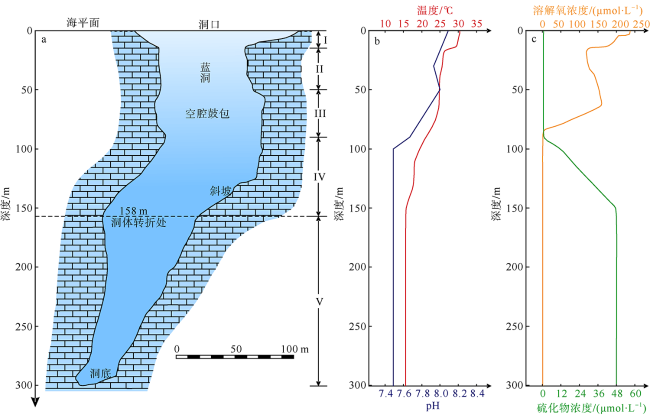
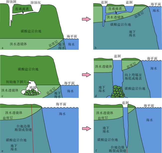
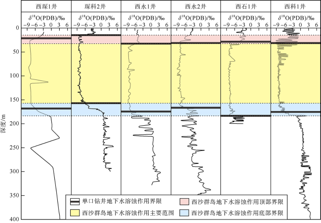
海洋蓝洞保留了原始的水体、沉积物、化石残骸和完整的生物骨骼, 是重要的自然遗产和地质奇观, 具有重要的科学研究价值。三沙永乐蓝洞是目前全球已发现的最深海洋蓝洞, 有着独特的洞体结构和水体化学特征, 但其成因仍是未解之谜。本文结合南海的构造演化, 分析了永乐环礁碳酸盐岩台地的发育历史, 认为永乐环礁的形成以加积和退积为主, 其台地边缘属于陡崖型台地斜坡, 有利于发育断层/裂缝; 永乐环礁之上钻井岩心的氧同位素数据表明, 永乐环礁在14.75~168.60m的深度范围内发生了地下水溶蚀作用, 这与实际观测到的158m深洞体转折处之上发生的洞穴垮塌作用相符。通过综合对比分析认为, 三沙永乐蓝洞的形成是断层/裂缝溶蚀机制与深部洞穴垮塌机制综合作用的结果。地下水(淡水、海水)首先沿着台地边缘发育的断层/裂缝进行溶蚀, 在158m以上通过洞穴垮塌作用形成了近垂直的洞穴, 而在158m以下则沿着断层/裂缝继续向下溶蚀形成了略倾斜的深部洞穴结构, 最终由于海平面的上升淹没而形成了蓝洞。本研究可为未来寻找更多海洋蓝洞提供重要的经验与借鉴。
高金尉 , 付腾飞 , 赵明辉 , 张汉羽 , 田丽艳 . 三沙永乐蓝洞成因机制初探*[J]. 热带海洋学报, 2022 , 41(1) : 171 -183 . DOI: 10.11978/2021077
Blue holes retain original water, sediments, fossil remains, and intact organic skeletons, which are important natural heritages and geologic miracles and have great scientific values. As the deepest blue hole discovered in the world, the Sansha Yongle Blue Hole (SYBH) has typical cavity structure and hydrochemistrical characteristics; however, its formation process is still a scientific puzzle. Based on the tectonic evolution of the South China Sea, we analyze the development history of carbonate platform in Yongle Atoll. Formation of Yongle Atoll is mainly attributed to the aggradation and backstepping of carbonate platform that could generate escarpment to erosional platform margins and facilitate development of faults/fractures along the banks. According to oxygen isotopes (δ18O) in carbonate cores from the drilled wells of Yongle Atoll, phreatic dissolution mainly occurred from 14.75 m to 168.60 m in depth, which agrees with collapse of deep voids observed above the cave break at the depth 158m in Yongle Atoll. Compared with other blue holes and caves in the world, we propose that the formation of the SYBH is due to a combined action of fault/fracture of bank margin and collapse of deep voids. Phreatic (fresh water and sea water) dissolution along the fault/fracture formed sub-vertical sinkhole above 158 m in depth through collapse of deep voids, whereas it continued to work along fault/fracture to form a slightly inclined and narrower cave downward below 158m. Then, the SYBH finally evolved into a deep blue hole due to flooding of rising sea level. This study provides important knowledge and reference for exploring other blue holes in the future.
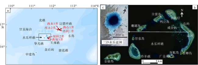
图2 西沙群岛各岛礁位置图(a)、永乐环礁卫星照片(b)与三沙永乐蓝洞航拍照片(c)图2a (a) Location map of atolls in the Xisha Islands (location marked as a box in |
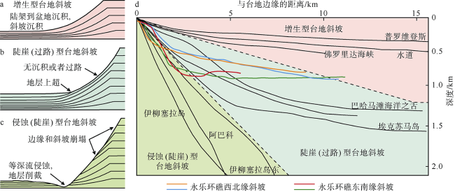
图3 增生型(a)、陡崖型(b)和侵蚀型(c)台地边缘地层模型和斜坡曲线(d)图a Stratal models and slope profiles of accretionary, escarpment, and erosional platform margins. (a-c) Models of accretionary, escarpment, and erosional platform margins with depositional characteristics (modified from Playton et al, 2010); (d) slope profiles of different platform slope patterns showing variations in slope angle and slope height. Color lines represent the slopes of Yongle Atoll derived from multi-beam bathymetric data and seismic reflection profiles. Black lines are other carbonate margins modified from Playton et al (2010) |
图4 永乐孤立碳酸盐岩台地(左)随南海构造演化(右)的发育史示意图ASRRSZ: 哀牢山-红河断裂带; MT: 马尼拉海沟; XT: 西沙海槽; ZF: 中南断裂; DI: 东沙群岛; ZI: 中沙群岛; XI: 西沙群岛; MI: 民都洛岛; LB: 礼乐滩; PI: 巴拉望岛; NI: 南沙群岛; 南海构造演化图(右)改自Li等(2015) Fig. 4 Evolutionary of Yongle isolated carbonate platform (left) with the tectonic evolution of the South China Sea (right). ASRRSZ: Ailao Shan-Red River Shear Zone; MT: Manila Trench; XT: Xisha Trough; ZF: Zhongnan Fault; DI: Dongsha Islands; ZI: Zhongsha Islands; XI: Xisha Islands; MI: Mindoro Island; LB: Liyue Bank; PI: Palawan Island; NI: Nansha Islands. Right panels are modified from Li et al (2015) |
图7 西沙群岛6口钻井岩心的氧同位素曲线黑色条带标定了6口钻井的地下水溶蚀作用范围, 有虚线边界的粉色和蓝色区域分别代表了西沙群岛地区地下水溶蚀作用的顶、底界限, 黄色区域代表了地下水溶蚀作用的主要范围; 西琛1井、西永1井、西永2井和西石1井的氧同位素曲线源自赵强(2010), 琛科2井的氧同位素曲线源自Jiang等(2019), 西科1井的氧同位素曲线源自Shao等(2017); 各井位置详见 Fig. 7 Oxygen isotopes (δ18O) in carbonate cores from six drilled wells of Xisha Islands. Black strips mark the phreatic dissolution extent of six drilled wells; purple and blue areas with dashed lines represent the top and bottom boundaries of phreatic dissolution extent in the Xisha Islands, respectively; and yellow area represents the main phreatic dissolution extent. δ18O data of wells Xichen-1, Xiyong-1, Xiyong-2, and Xishi-1 are from Zhao (2010); data of Well Chenke-2 are from Jiang et al (2019); and data of Well Xike-1 are from Shao et al (2017). See |
*感谢两位审稿专家的建设性修改建议和意见及编辑部老师的耐心指导。
| [1] |
毕乃双, 傅亮, 陈洪举, 等, 2018. 南海三沙永乐龙洞关键水体环境要素特征及其影响因素[J]. 科学通报, 63(21): 2184-2194.
|
| [2] |
范德江, 田元, 傅亮, 等, 2018. 南海西沙永乐龙洞沉积物组成、来源及其沉积作用[J]. 海洋与湖沼, 49(6): 1203-1210.
|
| [3] |
李建坤, 李铁刚, 丰爱平, 等, 2019. 三沙永乐龙洞洞底沉积速率变化及其影响因素[J]. 海洋学报, 41(5): 107-117.
|
| [4] |
李学林, 张汉羽, 刘刚, 等, 2020. 西沙孤立碳酸盐台地的地震层序及演化模式--以永乐环礁为例[J]. 海洋地质与第四纪地质, 40(5): 87-96.
|
| [5] |
刘焱雄, 杜军, 吴志露, 等, 2017. 西沙永乐龙洞探秘前期调查工作综述[J]. 海洋科学进展, 35(3): 305-316.
|
| [6] |
罗珂, 田元, 傅亮, 等, 2019. 三沙永乐龙洞洞内侧壁礁体矿物和元素组成及其晚更新世以来的形成演化[J]. 海洋与湖沼, 50(5): 1014-1021.
|
| [7] |
徐国强, 吕炳全, 王红罡, 2002. 新生代南海北部碳酸盐岩台地的淹没事件研究[J]. 同济大学学报, 30(1): 35-40.
|
| [8] |
赵强, 2010. 西沙群岛海域生物礁碳酸盐岩沉积学研究[D]. 青岛: 中国科学院研究生院(海洋研究所).
|
| [9] |
|
| [10] |
|
| [11] |
|
| [12] |
|
| [13] |
|
| [14] |
|
| [15] |
|
| [16] |
|
| [17] |
|
| [18] |
|
| [19] |
|
| [20] |
|
| [21] |
|
| [22] |
|
| [23] |
|
| [24] |
|
| [25] |
|
| [26] |
|
| [27] |
|
| [28] |
|
| [29] |
|
| [30] |
|
| [31] |
|
| [32] |
|
| [33] |
|
| [34] |
|
| [35] |
|
| [36] |
|
| [37] |
|
| [38] |
|
| [39] |
|
| [40] |
|
| [41] |
|
| [42] |
|
| [43] |
|
| [44] |
|
| [45] |
|
| [46] |
|
| [47] |
|
| [48] |
|
| [49] |
|
| [50] |
|
| [51] |
|
| [52] |
|
| [53] |
|
| [54] |
|
| [55] |
|
| [56] |
|
| [57] |
|
| [58] |
|
| [59] |
|
| [60] |
|
| [61] |
|
| [62] |
|
| [63] |
|
| [64] |
|
| [65] |
|
| [66] |
|
/
| 〈 |
|
〉 |


