
晚中生代以来太平洋域板块过程及其对东亚陆缘构造研究的启示
作者简介:周蒂(1944—), 女, 博士, 研究员。主要从事海洋地质与模拟研究。E-mail: zhoudiscs@scsio.ac.cn
收稿日期: 2016-09-30
要求修回日期: 2016-12-21
网络出版日期: 2017-06-01
基金资助
国家自然科学基金委员会—广东省联合基金项目(U1301233)
Plate evolution in the Pacific domain since Late Mesozoic and its inspiration to tectonic research of East Asia margin
Received date: 2016-09-30
Request revised date: 2016-12-21
Online published: 2017-06-01
Supported by
Joint Program of National Natural Science Foundation of China and Guangdong Province (U1301233)
Copyright
周蒂 , 孙珍 . 晚中生代以来太平洋域板块过程及其对东亚陆缘构造研究的启示[J]. 热带海洋学报, 2017 , 36(3) : 1 -19 . DOI: 10.11978/2016092
Since the Late Mesozoic, the plate evolution in the Pacific domain has influenced the tectonic evolution, magmatism and mineralization of the East Asia margin. Improving our knowledge about the Pacific evolution will benefit our understanding of the tectonic evolution of East Asia continental margin. In this paper, we summarize updated research results on the tectonic evolution of the paleo and present Pacific Ocean from three aspects, the distinction between Pacific and Tethys tectonic domains, important tectonic events during Pacific evolution and the ridge subduction around the Pacific. Possible effects of Pacific domain on the evolution of East Asia continental margin are probed. Our aim is to call on more intensified research on Asia continent and Pacific Ocean, and to provide an easy reference for such research.
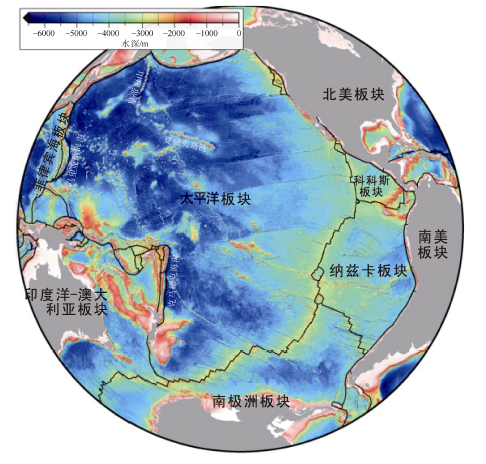
Fig. 1 Topographic map of the Pacific Ocean. After Wright et al (2016)图1 太平洋地形图[源自Wright等(2016)]^黑色实线表示板块边界 |
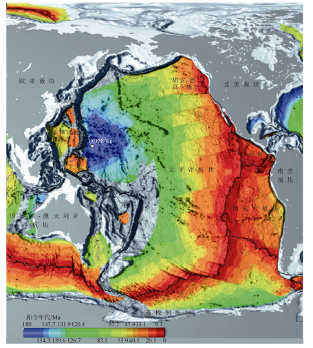
Fig. 2 Seafloor age of the Pacific Ocean图2 太平洋洋底年龄图(截自http://www.ngdc.noaa.gov/mgg/image/images/g01167-pos-a0001.pdf)^黑色实线表示板块边界; 白色圆点示ODP801c站位 |
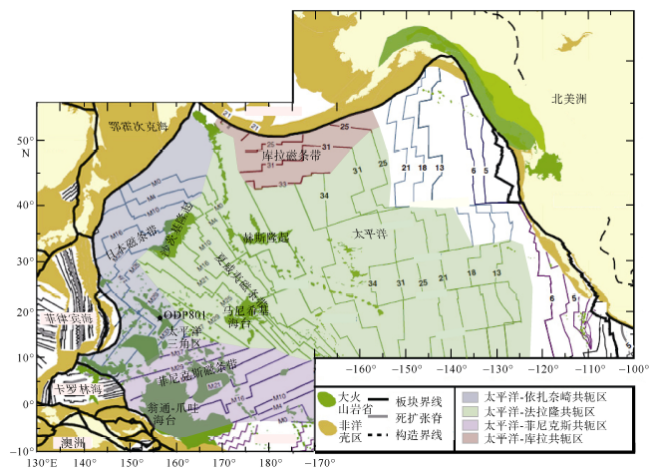
Fig. 3 Magnetic anomalies in the northwestern Pacific Ocean. After Seton et al (2012)图3 西北太平洋磁条带简图[据Seton等(2012)编辑译注]^图中数字表示磁条带编号。本文作者注:图中太平洋三角区的磁条带编号有误: ODP801站位(五角星)处的磁条带应为M42 |
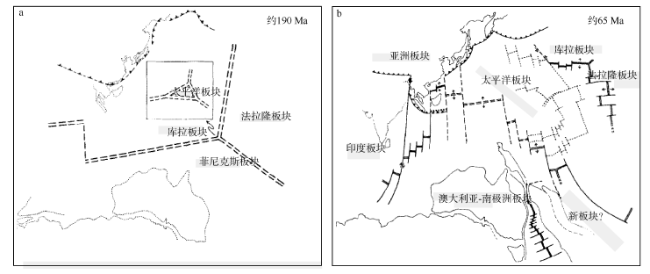
Fig. 4 Early evolution of the Pacific Ocean. After Hilde et al (1977)图4 早期的太平洋演化模式图[译自Hilde等(1977)]^a. 约190Ma时, 太平洋诞生于库拉—法拉隆—菲尼克斯三大板块的三联点处; b. 图a方框位置。约65Ma时, 库拉板块西段已基本俯冲潜没, 而东段尚继续扩张并向北俯冲。后期的研究认为所谓“库拉板块西段”应该是另一个板块, 称为“依扎奈崎板块”(Sager et al, 1988; Nakanishi et al, 1989)。黑色实线和虚线表示扩张脊; 单虚线表示转换断层; 齿线表示俯冲带; 灰色实、虚细线表示陆、岛边界 |
Fig. 5 Evolution of the Paleo Pacific Ocean. After Wan (2007)图5 古太平洋板块演化简图[转译自万天丰(2007)]^双线表示扩张洋脊; 齿线表示俯冲带; 箭头表示板块漂移方向 |
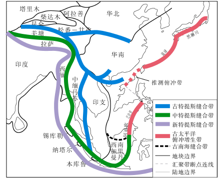
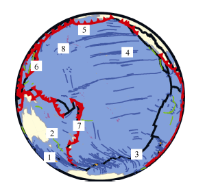
Fig. 6 Sketch map showing the locations of paleo convergent belts of Tethyan and Pacific domains. After Zhou et al (2008)图6 特提斯域和太平洋域古汇聚带在东南亚的展布示意图[据Zhou等(2008)修改]^在晚侏罗世到白垩纪期间, 东南亚边缘被俯冲增生带环绕, 西段为中特提斯缝合带, 东段为古太平洋俯冲增生带 |
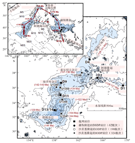
Fig. 7 The map of bathymetry, sampling sites and ages of the Shatsky Rise (a), and the map of locations and magnetic anomalies of the Shatsky and Hess rises. After Tejada et al (2016)图7 沙茨基隆起隆起的水深、样品位置和40Ar-39Ar年龄图(a)和沙茨基隆起和赫斯隆起的区域位置和磁条带展布图(b) [译自Tejada等(2016)]^图b中虚线及注释表示磁条带及其编号, 红色箭头和数字显示推测的热点轨迹及相应的年龄, 可见约128Ma左右热点轨迹发生了约90°的转折 |
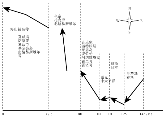
Fig. 8 Schematic diagram showing the drift of the Pacific Plate with respect to a fixed hotspot reference frame. Compiled according to |
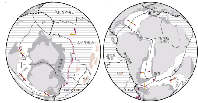
Fig. 9 Plate reconstruction for 105-100 Ma showing major tectonic events. After Matthews et al (2012)图9 105~100Ma板块回溯图, 显示当时的主要构造事件[译自Matthews等(2012)]^a. 东冈瓦纳区域; b. 大西洋区域。红/橙色箭头分别表示前/后板块运动方向(不按比例); 齿线表示俯冲带, 其中红色段表示当时终止活动的东冈瓦纳俯冲带; 五角星表示布韦(Bouvet)地幔柱位置; 浅灰和深灰色块分别表示陆地和大陆架; 粉色块表示大火山岩省; 横线阴影表示后来被俯冲掉的洋底。S: 海底扩张开始处; CE: 挤压事件发生处; CaP: 卡特奎尔(Catequil)板块; ChP: 查兹卡(Chazca)板块; HP: 希库朗伊(Hikurangi)板块; IB: 伊比利亚(Iberian)板块; JP: 江可申(Junction)板块; MP: 马尼希基(Manihiki)板块 |
Fig. 10 The expressions of the Early Eocene event in the Pacific Ocean and adjacent areas. After Seton et al (2015)图10 早始新世事件在太平洋及邻域的表现[自Seton等(2015)]^1. 澳大利亚—南极扩张方向改变(53~50Ma); 2. 塔斯曼、珊瑚海扩张停止(52Ma); 3. 南太平洋三联点重组(50~48Ma); 4. 法拉隆板块再分裂, 温哥华板块形成成(53Ma); 5. 库拉板块扩张方向由SN变为NW—SE (53Ma)和停止扩张(41Ma); 6. 伊豆—小笠原—马里亚纳火山弧开始形成(51~48Ma); 7. 沿汤加—克马德克火山弧的俯冲开始; 8. 夏威夷—皇帝岛链转折及太平洋漂移方向45°逆时针旋转(53~47Ma)。图中黑色粗线表示洋中脊; 红色齿线表示俯冲带; 浅黄色表示陆地; 浅蓝色表示海洋; 深蓝线表示转换断层; 紫色表示火山岛 |
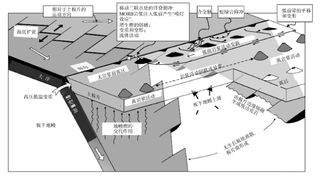
Fig. 11 Schematic block diagram illustrating various geological processes associated with the subduction of the Kula- Farallon Ridge towards the North American Cordillera. From Sisson et al (2003)图11 扩张脊俯冲相伴的地质过程示意图[据库拉—法拉隆扩张脊向北美科迪勒拉俯冲的实例绘制, 译自Sisson等(2003)] |
Fig. 12 Models for the subduction of the Izanagi-Pacific Ridge图12 依扎奈崎—太平洋扩张脊俯冲模式图^a和b: 白垩纪近垂直俯冲模式。白垩纪时扩张脊与海沟近垂直地俯冲, 且三联点向北东位移(Maruyama et al, 1997)。黄色箭头及其标示: 板块运动方向及其速率。c: 早古近纪近平行俯冲模式。早古近纪时扩张脊与海沟近平行地俯冲(Seton et al, 2012); IZA: 依扎奈崎板块; PAC: 太平洋板块; JUN: 江可申板块; LHR: 豪勋爵隆起板块; 黑色箭头表示板块运动方向。d: 早白垩世斜交俯冲模式。早白垩世时扩张脊向下扬子地块俯冲, 与海沟大角度相交(Ling et al, 2009); 黑色箭头表示板块运动方向 |
The authors have declared that no competing interests exist.
| [1] |
Tethyan geology for 100 years[J]. Tethyan Geology, (18): 1-22 (in Chinese).
|
| [2] |
|
| [3] |
|
| [4] |
|
| [5] |
|
| [6] |
|
| [7] |
|
| [8] |
|
| [9] |
|
| [10] |
|
| [11] |
|
| [12] |
|
| [13] |
|
| [14] |
|
| [15] |
|
| [16] |
|
| [17] |
|
| [18] |
|
| [19] |
|
| [20] |
|
| [21] |
|
| [22] |
|
| [23] |
|
| [24] |
|
| [25] |
|
| [26] |
|
| [27] |
|
| [28] |
|
| [29] |
|
| [30] |
|
| [31] |
|
| [32] |
|
| [33] |
|
| [34] |
|
| [35] |
|
| [36] |
|
| [37] |
|
| [38] |
|
| [39] |
|
| [40] |
|
| [41] |
|
| [42] |
|
| [43] |
|
| [44] |
|
| [45] |
|
| [46] |
|
| [47] |
|
| [48] |
|
| [49] |
|
| [50] |
|
| [51] |
|
| [52] |
|
| [53] |
|
| [54] |
|
| [55] |
|
| [56] |
|
| [57] |
|
| [58] |
|
| [59] |
|
| [60] |
|
| [61] |
|
| [62] |
|
| [63] |
|
| [64] |
|
| [65] |
|
| [66] |
|
| [67] |
|
| [68] |
|
| [69] |
|
| [70] |
|
| [71] |
|
| [72] |
|
| [73] |
|
| [74] |
|
| [75] |
|
| [76] |
|
| [77] |
|
| [78] |
|
| [79] |
|
| [80] |
|
| [81] |
|
| [82] |
|
| [83] |
|
| [84] |
|
| [85] |
|
| [86] |
|
| [87] |
|
| [88] |
|
| [89] |
|
| [90] |
|
| [91] |
|
| [92] |
|
| [93] |
|
| [94] |
|
| [95] |
|
| [96] |
|
| [97] |
|
| [98] |
|
| [99] |
|
| [100] |
|
/
| 〈 |
|
〉 |


