
珠江口区域海陆联合三维地震构造探测的数据处理与震相识别*
作者简介:吕作勇(1984—), 男, 江西省信丰县人, 在读博士, 主要从事地震监测和深部结构研究。E-mail: 154471897@qq.com
收稿日期: 2016-08-11
要求修回日期: 2016-09-29
网络出版日期: 2017-06-01
基金资助
地震科技星火计划项目(XH16029Y)
国家自然基金面上项目(41676057、41674092)
广东省局合作项目
Data processing and phase identification of onshore-offshore 3D seismic exploration in Zhujiangkou area*
Received date: 2016-08-11
Request revised date: 2016-09-29
Online published: 2017-06-01
Supported by
Science for Earthquake Resilience (XH16029Y)
National Natural Science Foundation of China (41676057, 41674092)
Cooperation Project between Earthquake Bureau and Province of Guangdong
Copyright
吕作勇 , 丘学林 , 叶春明 , 孙金龙 , 段永红 , 吕金水 . 珠江口区域海陆联合三维地震构造探测的数据处理与震相识别*[J]. 热带海洋学报, 2017 , 36(3) : 80 -85 . DOI: 10.11978/2016076
Using offshore airguns and onshore explosions as seismic sources, along with portable seismic stations, permanent seismic stations and Ocean Bottom Seismometer (OBS) as a synchronously receiving array, a onshore-offshore 3D seismic exploration experiment was carried out for the first time in the Zhujiangkou area of the northern South China Sea. This paper introduces in detail the seismic data acquisition, observation system, data preprocessing method, and phase identification. A variety of seismic phases, including Pg, PcP, PmP, Pn, and Sg, can be clearly identified in most data collected by the permanent, portable seismic stations and OBS. Jointly using airgun and explosion sources, and dense stations receiving seismic signals simultaneously both on land and at sea, it can highly improve the ray coverage and cross overlap beneath the onshore-offshore transitional belt, which lays a foundation for obtaining fine crustal structure beneath such onshore-offshore area.
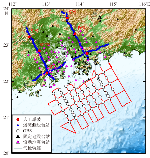
Fig. 1 Location map of 3D deep seismic survey lines, stations and active sources in Zhujiangkou area图1 珠江口区域海陆联合三维地震构造探测的测线、台站和主动源分布^图中带白点的粉色三角和黑色三角、带黑点的圆圈为下文用到的站点,站点代码分别为B06、NAA和OBS42 |
Tab. 1 Explosion parameters表1 人工爆破参数表 |
| 编号 | 爆破时刻 | 经度 | 纬度 | 高程/m | 药量/kg |
|---|---|---|---|---|---|
| SP3 | 2015-6-11 02:20:16.088 | 114°15′22.824″ | 22°46′17.112″ | 130 | 1992 |
| SP5 | 2015-6-12 02:00:14.678 | 112°32′11.652″ | 23°13′51.204″ | 51 | 2496 |
| SP2 | 2015-6-12 02:20:16.183 | 113°03′34.524″ | 22°14′24.504″ | -10 | 1992 |
| SP6 | 2015-6-13 02:10:14.435 | 113°40′2.532″ | 23°44′41.460″ | 241 | 2496 |
| SP5X | 2015-6-19 02:10:13.645 | 112°50′9.816″ | 22°50′59.136″ | 67 | 1008 |
| SP6X | 2015-6-21 02:00:14.478 | 113°53′43.764″ | 23°18′52.272″ | 124 | 1008 |
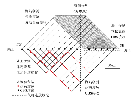
Fig. 2 Diagram of onshore-offshore observation system图2 海陆联测观测系统示意图 |
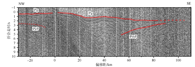
Fig. 3 Seismic record section of SP3 explosion on L2, reduced velocity is 6km•s-1图3 L2测线上的SP3爆破的地震记录剖面图, 折合速度为6km•s-1^图中红线为震相拾取示意线 |
Fig. 4 Seismic record section of marine station OBS42, reduced velocity is 6km•s-1图4 海域OBS42台站的地震记录剖面图, 折合速度为6km•s-1^图中红线为震相拾取示意线 |
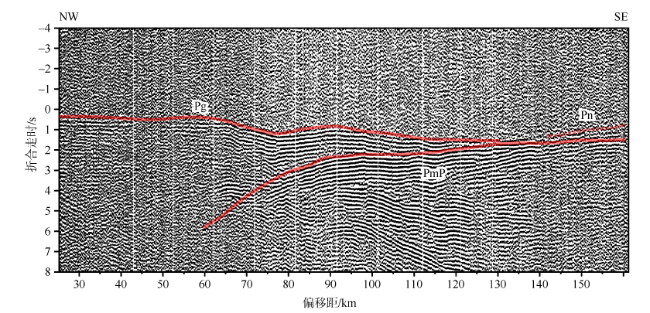
Fig. 5 Seismic record section of permanent seismic station NAA, reduced velocity is 6km•s-1图5 固定地震台站NAA的地震记录剖面图, 折合速度为6km•s-1^图中红线为震相拾取示意线 |
Fig. 6 Seismic record section of portable seismic station B06, reduced velocity is 6km•s-1图6 流动地震台站B06的地震记录剖面图, 折合速度为6km•s-1^图中红线为震相拾取示意线 |
The authors have declared that no competing interests exist.
| [1] |
|
| [2] |
|
| [3] |
|
| [4] |
|
| [5] |
|
| [6] |
|
| [7] |
|
| [8] |
|
| [9] |
|
| [10] |
|
| [11] |
|
| [12] |
|
| [13] |
|
| [14] |
|
| [15] |
|
/
| 〈 |
|
〉 |


