
北印度洋苏门答腊和莫克兰俯冲带地震海啸综述
作者简介:赵旭(1990#cod#x02014;), 男, 山东省聊城市人, 博士研究生, 主要从事海洋地球物理研究。E-mail: zhaoxu@scsio.ac.cn
收稿日期: 2016-11-18
要求修回日期: 2016-12-22
网络出版日期: 2018-01-18
基金资助
中国科学院率先行动#cod#x0201c;百人计划#cod#x0201d;人才项目(Y6YB011001)
国家自然科学基金项目(41676044、91628301、U1606401)
中国科学院项目(QYZDY-SSW-DQC005、Y4SL021001)
Review of tsunami caused by large earthquakes along the Sumatra and Makran subduction zones in the North Indian Ocean
Received date: 2016-11-18
Request revised date: 2016-12-22
Online published: 2018-01-18
Supported by
CAS Pioneer Hundred Talents Program (Y6YB011001)
National Natural Science Foundation of China (41676044, 91628301, U1606401)
Chinese Academy of Sciences Project (QYZDY-SSW-DQC005, Y4SL021001)
Copyright
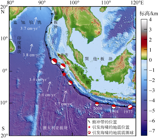
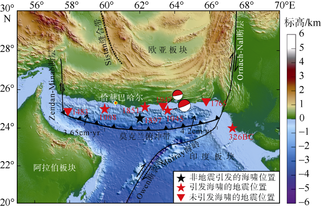
印度洋海啸发生的频率远低于太平洋, 但2000年以来全球因地震引发的10个重大海啸有3个发生在印度洋区域。苏门答腊和莫克兰俯冲带是北印度洋中地震海啸活动较活跃的两个区域。在苏门答腊俯冲带北端, 2004年12月26日和2005年3月28日分别发生了里氏9.0级和8.6级大地震, 是1961年以来的第2及第4强震。前者引发了最大爬高50.9m的海啸, 造成了历史上最大的海啸灾难; 后者却只引发了最大4m的爬高。位置相近、震源机制相似的两次地震引发的海啸灾害完全不同的原因非常值得研究。近期研究表明莫克兰俯冲带的地震活动分为东西两段, 东段的地震活动明显多于西段。东段于1945年发生过大海啸, 莫克兰西段或是全段俯冲带未来是否会发生大地震与海啸值得深入探讨研究。
赵旭 , 徐敏 , 曾信 , 林间 . 北印度洋苏门答腊和莫克兰俯冲带地震海啸综述[J]. 热带海洋学报, 2017 , 36(6) : 62 -70 . DOI: 10.11978/2016121
The frequency of tsunamis occurred in the Indian Ocean is much lower than that of the Pacific Ocean; in the past fifteen years, however, three out of ten major tsunamis triggered by the earthquake occurred in the Indian Ocean region. The Makran and the Sumatra subduction zones are the two active regions in the North Indian Ocean for tsunamigenic earthquakes. In the northern Sumatra subduction zone, two earthquakes with Mw 9.0 and 8.6 occurred on December 26, 2004 and March 28, 2005, respectively, and they were ranked as the second and fourth largest earthquakes in the past half century. The 2004 event generated a tsunami disaster with the largest wave runup of 50.9m, and resulted in the most devastating historical disaster, while the 2005 event only generated a maximum wave runup of 4m. What caused the completely different tsunami scenarios by the two earthquakes with similar location and focal mechanism is worthy of study. Recent studies showed that the seismic activities along the Makran subduction zone were divided into two neighboring sections: the seismic activity of the eastern section is significantly stronger than the western section, and the 1945 tsunami was located in this section. Whether the western section, or the whole Makran subduction zone has the potential to rupture together and thus generate major tsunamis requires further investigations.
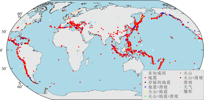
Fig. 1 Global distribution map of tsunamis caused by different mechanisms (Data obtained from NGDC/WDS)图1 全球不同成因海啸分布图(数据来自National Geophysical Data Center / World Data Service) |
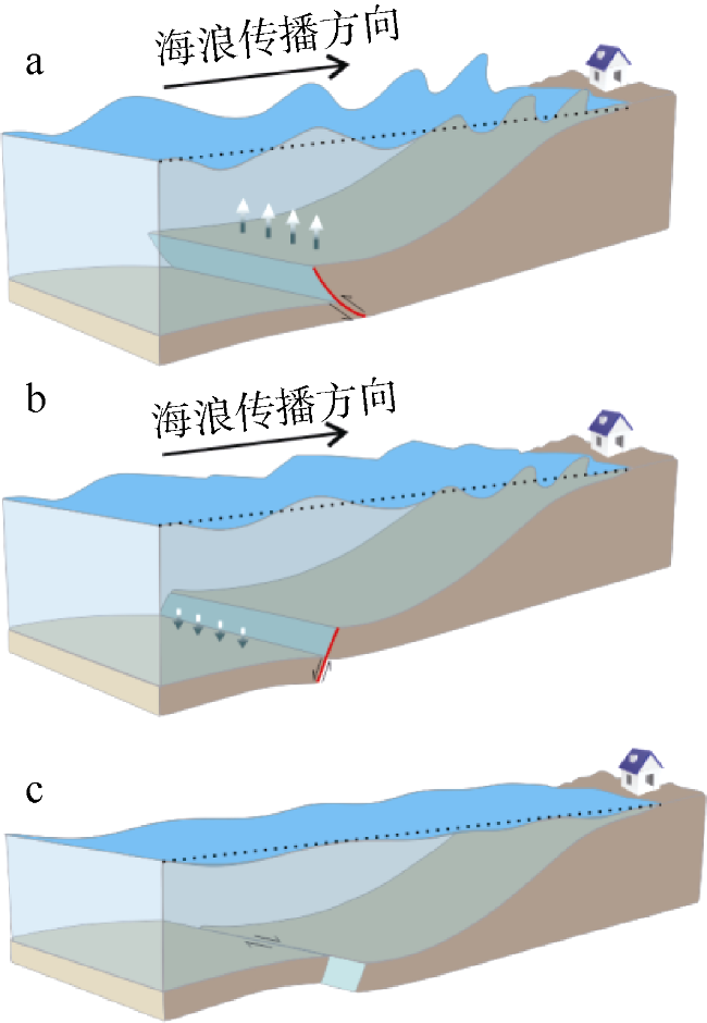
Fig. 2 Cartoon of ocean wave propagation triggered by thrust (a), normal (b), and strike-slip (c) fault earthquakes图2 逆冲断层(a)、正断层(b)及走滑断层(c)地震活动引发海浪波动的示意图 |
Tab. 1 Tsunamis generated in the Sumatra subduction zone since 1976 (Data obtained from National Geophysical Data Center/World Data Service)表1 1976年以来苏门答腊俯冲带发生的海啸(数据来自National Geophysical Data Center/World Data Service) |
| 时间 | 震级(Mw) | 震源深度/km | 纬度 | 经度 | 最大爬高/m |
|---|---|---|---|---|---|
| 2010/10/25 | 7.8 | 20 | 3°42′36″S | 99°19′12″E | 16.9 |
| 2006/07/17 | 7.7 | 34 | 10°16′48″S | 107°46′48″E | 20.9 |
| 2005/03/28 | 8.6 | 30 | 1°40′12″N | 97°04′12″E | 4.2 |
| 2004/12/26 | 9.0 | 30 | 3°05′24″N | 94°15′36″E | 50.9 |
| 1994/06/02 | 7.8 | 18 | 11°01′48″S | 113°02′24″E | 13.9 |
| 1977/08/19 | 8.3 | 33 | 11°08′24″S | 118°13′48″E | 15 |
Fig. 3 The location and focal mechanism of the tsunamigenic earthquakes in the Sumatra subduction zone (Dziewonski et al, 1981; Ekstr#cod#x000f6;m et al, 2012). Tsunami information can be seen in |
Fig. 4 Tectonic setting of the Makran subduction zone and tsunamigenic earthquakes with documented locations (Byrne et al, 1992; Heidarzadeh et al, 2009; Hoffmann et al, 2013; International Seismological Centre, 2013)图4 莫克兰俯冲带构造特征以及有位置记录的地震海啸(Byrne et al, 1992; Heidarzadeh et al, 2009; Hoffmann et al, 2013; International Seismological Centre, 2013) |
Tab. 2 Tsunamis caused by earthquakes documented in the Makran subduction zone表2 莫克兰俯冲带发生的有记录的地震海啸 |
| 时间 | 位置 | 海啸描述 | 参考文献 |
|---|---|---|---|
| 1945 AD | 24°88′48″N, 63°36′E | Mw 8.1级地震, 海啸爬高12~15m | Quittmeyer et al, 1979; Ambraseys et al, 1982; Pararas-Carayannis, 2006a |
| 1897 AD | 24°30′N, 62°E | 由地震或火山引发海啸 | Heidarzadeh et al, 2008 |
| 1851 AD | 25°6′N, 62°18′E | 莫克兰中部发生大地震并引发海啸, 数间房屋被摧毁 | Quittmeyer et al, 1979 |
| 1524 AD | 莫克兰俯冲带 | 地震引发的海啸损坏了印度Dabhol沿岸的葡萄牙舰队 | Rastogi et al, 2006; Heidarzadeh et al, 2008 |
| 1008 AD | 25°N, 60°E | 伊朗南部沿海有地震与海啸记载 | Ambraseys et al, 1982; Heidarzadeh et al, 2008; Shah-HosseinI et al, 2011 |
| 326 BC | 24°N, 67°18′E | 印度西部的马其顿舰队被摧毁 | Murty et al, 1999; Pararas-Carayannis, 2006b; Rastogi et al, 2006; Heidarzadeh et al, 2008 |
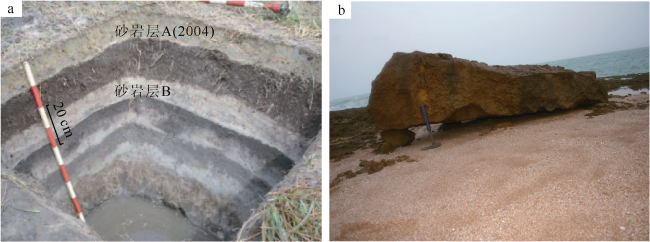
Fig. 5 Paleotsunami research.(a) Cross-sectioned shape of sand sheets on Thailand#cod#x02019;s Phra Thong Island (Jankaew et al, 2008); (b) Boulder deposits in Chabahar coast of the southeastern Iran plucked by tsunami waves (http://inio.ac.ir/default.aspx?tabid=1723) 图5 古海啸研究 a. 泰国帕莱松岛的层状砂岩(Jankaew et al, 2008); b. 伊朗东南部恰赫巴哈尔海岸古海啸搬运到海岸的巨石沉积(http://inio.ac.ir/default.aspx?tabid=1723) |
| [1] |
|
| [2] |
中国新闻网, (2014-12-22) [2016-11-09]. 印度洋大海啸受灾国预警系统管理不当形同虚设[EB/OL].
|
| [3] |
.
|
| [4] |
|
| [5] |
|
| [6] |
|
| [7] |
|
| [8] |
DAWN, (2006-11-14) [2016-11-09]. Karachi: Pakistan to have tsunami warning system soon [EB/OL].
|
| [9] |
DAWN, (2009-10-16) [2016-11-09]. Pakistan successfully tests tsunami warning system[EB/OL].
|
| [10] |
|
| [11] |
|
| [12] |
|
| [13] |
|
| [14] |
|
| [15] |
. GEO, (2012-04-11) [2016-11-09]. Tsunami warning issued to 28 countries including Pakistan[EB/OL].
|
| [16] |
|
| [17] |
|
| [18] |
|
| [19] |
.INTERNATIONAL SEISMOLOGICAL CENTRE, on-line bulletin, 2013[EB/OL]. Thatcham, United Kingdom: International Seismological Centre.
|
| [20] |
|
| [21] |
|
| [22] |
|
| [23] |
|
| [24] |
|
| [25] |
|
| [26] |
|
| [27] |
|
| [28] |
|
| [29] |
|
| [30] |
|
| [31] |
|
| [32] |
|
| [33] |
|
| [34] |
|
| [35] |
|
| [36] |
|
| [37] |
|
| [38] |
|
| [39] |
|
| [40] |
|
| [41] |
|
| [42] |
|
| [43] |
|
| [44] |
|
| [45] |
|
| [46] |
|
| [47] |
|
| [48] |
|
| [49] |
|
/
| 〈 |
|
〉 |
