
滑行波震相对珠江口地区壳内低速层的约束作用
|
杨碧峰(1993—), 男, 湖南涟源市人, 硕士, 主要从事海洋地球物理研究。E-mail: yangbifeng16@mails.ucas.ac.cn |
Copy editor: 孙淑杰
收稿日期: 2019-03-01
要求修回日期: 2019-04-09
网络出版日期: 2020-01-09
基金资助
国家自然科学基金(41576046)
国家自然科学基金(41506046)
版权
Constrains of sliding wave phases on the low-velocity layer in the Pearl River Estuary
Received date: 2019-03-01
Request revised date: 2019-04-09
Online published: 2020-01-09
Supported by
National Natural Science Foundation of China(41576046)
National Natural Science Foundation of China(41506046)
Copyright
深入研究珠江口地区海陆过渡带壳内低速层的结构和构造特征对于理解板内地震的发震机理、孕震构造及该区域的地壳结构具有重要的地质地球物理意义。利用2015年珠江口区域海陆地震联测L2-ME测线上的19个地震台站(包括陆上台站14台, 海底地震仪5台)记录到的地震数据来探明该区域低速层的结构和构造特征。在常规震相的基础上, 加入了大量的滑行波震相(Ph)进行结构模型计算, Ph震相的增加使得地壳内部10~20km范围内的射线覆盖密度有了显著提高, 从而获得了L2-ME测线下方更为精确的地壳纵波速度结构模型。结果发现, 模型中测线下方13~18km深度范围内稳定连续展布的壳内低速层被清晰成像, 其内部速度稳定在5.7~6.0 km·s-1之间, 与上下层界面速度差分别为0.5km·s-1、0.4km·s-1, 低速特征明显。该低速层厚度由陆侧的3.5km左右降至海侧的1km, 呈现出向海侧逐渐减薄的趋势, 低速层底界面起伏变化较大且具有与莫霍面相似的起伏特征。
杨碧峰 , 熊成 , 曹敬贺 , 孙金龙 , 万奎元 , 夏少红 . 滑行波震相对珠江口地区壳内低速层的约束作用[J]. 热带海洋学报, 2020 , 39(1) : 106 -119 . DOI: 10.11978/2019020
Exploring the structure and tectonic characteristics of the low-velocity layer (LVL) in a transition zone of the Pearl River Estuary (PRE) area has significant geological and geophysical implications for understanding the mechanism of intraplate earthquakes, seismogenic structure and crustal structure in this area. In this study, we use the data from 19 seismic stations (include 14 onshore seismic stations and five ocean bottom seismometers) along the L2-ME profile of the 2015 onshore-offshore deep seismic experiment in the PRE area to image structure features of the LVL. On the basis of the conventional seismic phase, a large number of sliding wave seismic phases are added to calculate the structural model. With the increase of Ph seismic phases, the ray coverage density within the range of 10-20 km was significantly increased, and a more accurate P-wave velocity structure model of the LVL and its above crustal structure along the L2-ME profile were obtained. The result shows the LVL is clearly imaged in the crust within the depth range of 13-18 km under the profile. The velocity in the LVL is roughly stable in the range of 5.7-6.0 km·s-1 and has an obvious low-velocity anomaly feature of 0.5 km·s-1 difference compared with its top layer and of 0.4 km·s-1 difference compared with its bottom layer. Its thickness decreases from 3.5 km on the land side to 1 km on the sea side, showing a trend of gradual thinning toward the sea side. The bottom boundary of the LVL has similar fluctuation characteristics to the Moho.
图1 研究区位置及深地震探测测线分布图黄色方框为研究区范围, 紫色为发现壳内低速层的测线, 红色为本次研究所用测线 Fig.1 Location map of the onshore-offshore deep seismic survey lines in South China and transition zone. The yellow box is the study area, the purple line is the survey lines of the low-velocity layer, and the red line is the survey line used in this study |
表1 各典型震相拾取数量及拾取误差Tab. 1 The number and pick error of different phases |
| 震相 | 拾取数量 | 拾取误差/ms |
|---|---|---|
| Ps | 63 | 50 |
| Pg1 | 2960 | 80 |
| Pg2 | 191 | 80 |
| PmP | 2982 | 100 |
| 合计 | 6196 |
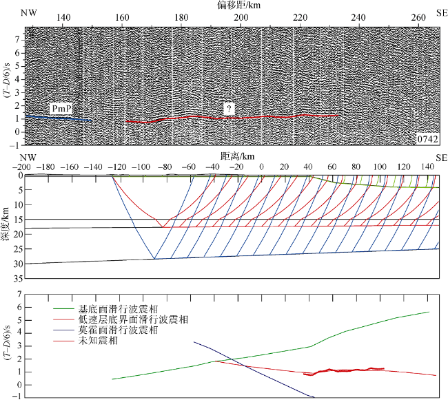
图4 本次研究中L2测线发现的未知震相(a、b)及 L1测线发现的未知震相(c) (熊成, 2018)(T-D/6)为折合走时, 其中T为实际走时, D为偏移距的值, 折合速度为6km·s-1 Fig. 4 The unknown phase found in seismic line L2 (a, b) and in seismic line L1 (c, After Xiong (2018)). (T-D/6) is the reduced travel time, T is the value of time, D is the value of offset, and reduced velocity is 6 km·s-1 |
图6 0742台站各典型震相与未知震相的理论走时对比(T-D/6)为折合走时, 其中T为实际走时, D为偏移距的值, 折合速度为6km·s-1 Fig. 6 The contrast of typical seismic phase with unknown phase in calculated travel time of station 0742. (T-D/6) is the reduced travel time, T is the value of time, D is the value of offset, and reduced velocity is 6 km·s-1 |
图7 0742台站可能产生的各类滑行波震相与未知震相的理论走时对比(T-D/6)为折合走时, 其中T为实际走时, D为偏移距的值, 折合速度为6km·s-1 Fig. 7 The contrast of possible sliding wave phase with unknown phase in calculated travel time of station 0742. (T-D/6) is the reduced travel time, T is the value of time, D is the value of offset, and reduced velocity is 6 km·s-1 |
表2 陆上地震台站Ph震相拾取数量、走时拟合残差和卡方(χ2)值Tab. 2 Number of travel times, Root Mean Square misfit and normalized χ2 of Ph phases for onshore seismic stations |
| 地震台站 | 分量 | 拾取误差/ms | Ph震相数 | 走时残差/s | χ2 |
|---|---|---|---|---|---|
| 0716 | 垂直 | 80 | 216 | 0.094 | 1.378 |
| 0729 | 垂直 | 50 | 293 | 0.047 | 0.886 |
| 0739 | 垂直 | 50 | 159 | 0.059 | 1.406 |
| 0741 | 垂直 | 80 | 250 | 0.107 | 1.782 |
| 0742 | 垂直 | 50 | 351 | 0.051 | 1.040 |
| 0755 | 垂直 | 80 | 137 | 0.098 | 1.523 |
| 0779 | 垂直 | 80 | 133 | 0.083 | 1.088 |
| 0789 | 垂直 | 80 | 251 | 0.076 | 1.113 |
| 合计 | 1790 |
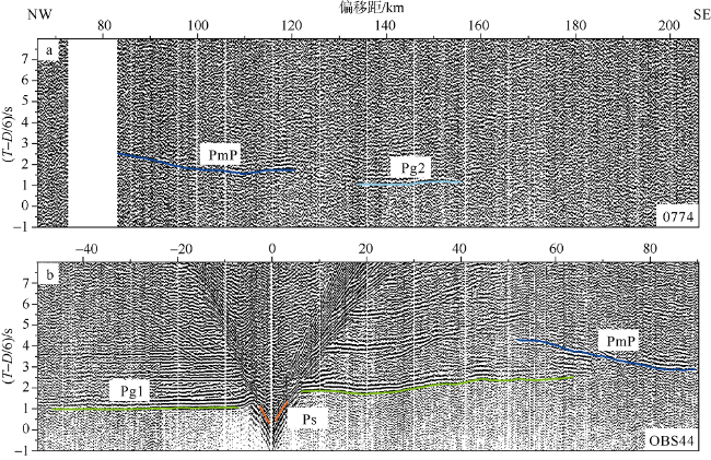
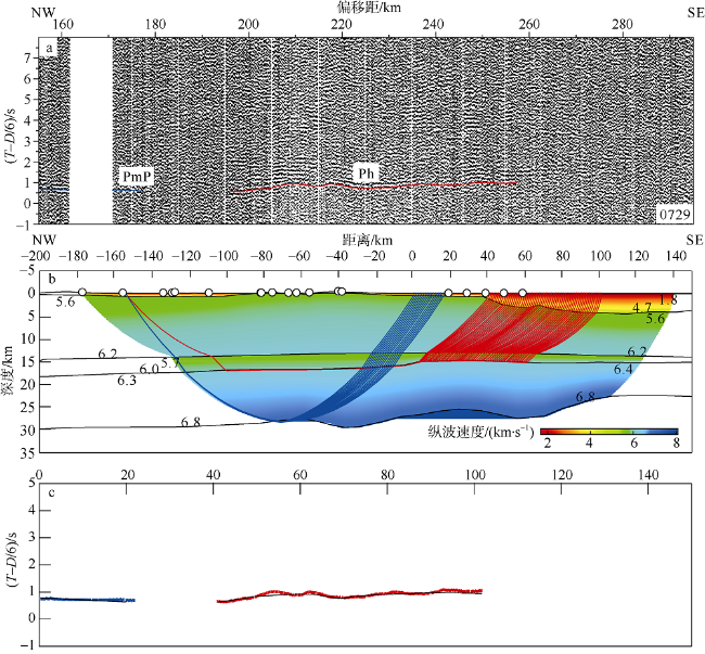
图8 0729台站地震记录剖面(a)、射线追踪(b)及走时拟合(c)(T-D/6)为折合走时, 其中T为实际走时, D为偏移距的值, 折合速度为6km·s-1 Fig. 8 Seismic record section (a), ray-tracing (b) and travel time fits (c) of station 0729. (T-D/6) is the reduced travel time, T is the value of time, D is the value of offset, and reduced velocity is 6 km·s-1 |
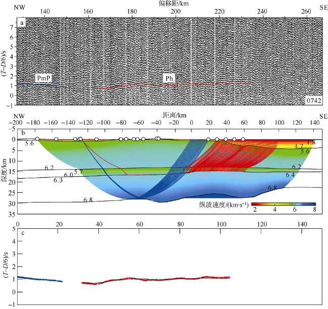
图9 0742台站地震记录剖面(a)、射线追踪(b)及走时拟合(c)(T-D/6)为折合走时, 其中T为实际走时, D为偏移距的值, 折合速度为6km·s-1 Fig. 9 Seismic record section (a), ray-tracing (b) and travel time fits (c) of station 0742. (T-D/6) is the reduced travel time, T is the value of time, D is the value of offset, and reduced velocity is 6 km·s-1 |
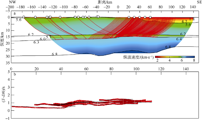
图10 L2-ME测线壳内低速层底界面滑行波震相的射线追踪(a)及走时拟合(b)(T-D/6)为折合走时, 其中T为实际走时, D为偏移距的值, 折合速度为6km·s-1 Fig. 10 Ray-tracing (a) and travel time fits (b) of the sliding wave phase of low-velocity layer in seismic line L2-ME. (T-D/6) is the reduced travel time, T is the value of time, D is the value of offset, and reduced velocity is 6 km·s-1 |
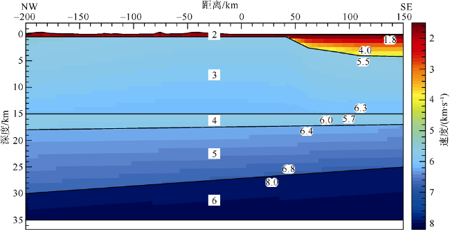
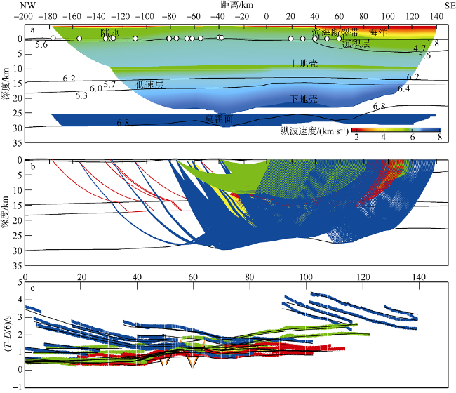
图12 L2-ME测线纵波速度结构模型(a)、射线追踪(b)及走时拟合(c)图b中射线抽稀比为5, 图c中(T-D/6)为折合走时, 其中T为实际走时, D为偏移距的值, 折合速度为6km·s-1 Fig. 12 P-wave velocity structure model (a), ray-tracing (b) and travel time fits (c) of seismic line L2-ME. The dilution ratio of ray in (b) is 5. (T-D/6) is the reduced travel time, T is the value of time, D is the value of offset, and reduced velocity is 6 km·s-1 |
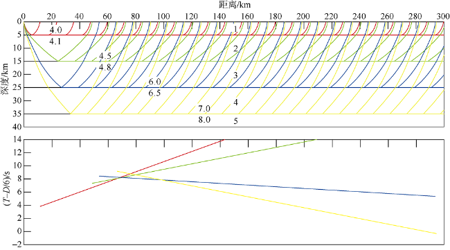
图13 各不同速度间断面产生的理论滑行波的射线路径及走时数字1~5代表不同层位, 左侧数字代表每一层位上下界面的纵波速度; (T-D/6)为折合走时, 其中T为实际走时, D为偏移距的值, 折合速度为6km·s-1 Fig. 13 Ray-tracing and travel time of theoretical sliding wave phase on different velocity discontinuity surfaces. The number 1~5 represent different layer and the left side digital represent P-wave velocity of upper and lower interface of each layer. (T-D/6) is the reduced travel time, T is the value of time, D is the value of offset, and reduced velocity is 6 km·s-1 |
| [1] |
曹敬贺 , 2014. 南海北部珠江口海域滨海断裂带的地震学特征研究[D]. 北京: 中国科学院大学: 1-133.
|
| [2] |
曹敬贺, 孙金龙, 徐辉龙 , 等, 2014. 珠江口海域滨海断裂带的地震学特征[J]. 地球物理学报, 57(2):498-508.
|
| [3] |
陈冰, 王家林, 钟慧智 , 等, 2005. 南海东北部的断裂分布及其构造格局研究[J]. 热带海洋学报, 24(2):42-51.
|
| [4] |
陈剑雄, 王宝善, 葛洪魁 , 等, 2011. 气枪探测资料对华北地区地壳低速带的约束[J]. 中国地震, 27(1):49-55.
|
| [5] |
邓阳凡, 李守林, 范蔚茗 , 等, 2011. 深地震测深揭示的华南地区地壳结构及其动力学意义[J]. 地球物理学报, 54(10):2560-2574.
|
| [6] |
丁原章, 黄新辉 , 1998. 珠江三角洲地区未来地震危险性预测[J]. 华南地震, 18(1):56-63.
|
| [7] |
胡小幸, 林邦慧 , 1989. 邢台地震空间分布随时间变化的立体图象与地震发生过程[J]. 地震学报, 11(1):1-11.
|
| [8] |
姜本鸿, 袁登维, 吴玉华 , 1992. 壳内低速层与地震活动关系[J]. 地质科技情报, 11(4):9-15.
|
| [9] |
李秋生 , 1998. 壳内低速层与大陆多震层[J]. 中国地质科学院562综合大队集刊, 13:28-40.
|
| [10] |
李松林, 苗琪, 王旭 , 2011. 华北地区的地壳低速层[J]. 大地测量与地球动力学, 31(5):35-38.
|
| [11] |
李新胜, 周俊乐 , 2007. 声幅-变密度测井原理及测井解释方法[J]. 陕西地质, 25(2):54-59.
|
| [12] |
李占咸, 王秀明, 杨建绥 , 等, 1992. 声波测井中几何声学的滑行波理论与波动力学理论的一致性[J]. 大庆石油学院学报, 16(4):1-7.
|
| [13] |
林纪曾, 梁国昭, 赵毅 , 等, 1980. 东南沿海地区的震源机制与构造应力场[J]. 地震学报, 2(3):245-257.
|
| [14] |
刘国栋, 顾群, 史书林 , 等, 1983. 京津唐渤和周围地区地壳上地幔电性结构及其与地震活动性的关系[J]. 地球物理学报, 26(2):149-157.
|
| [15] |
吕作勇, 丘学林, 叶春明 , 等, 2017. 珠江口区域海陆联合三维地震构造探测的数据处理与震相识别[J]. 热带海洋学报, 36(3):80-85.
|
| [16] |
宋海斌, 郝天珧, 江为为 , 等, 2002. 南海地球物理场特征与基底断裂体系研究[J]. 地球物理学进展, 17(1):24-34.
|
| [17] |
隋志强 , 2008. 声波测井中泥饼折射滑行波分析方法初探[J]. 石油地球物理勘探, 43(3):340-342.
|
| [18] |
孙武城, 李松林, 罗力雷 , 等, 1987. 初论华北地区的地壳低速层[J]. 地震地质, 9(1):17-26.
|
| [19] |
滕吉文, 白登海, 杨辉 , 等, 2008. 2008汶川Ms8.0地震发生的深层过程和动力学响应[J]. 地球物理学报, 51(5):1385-1402.
|
| [20] |
滕吉文 , 2010. 强烈地震孕育与发生的地点、时间及强度预测的思考与探讨[J]. 地球物理学报, 53(8):1749-1766.
|
| [21] |
王妙月 , 1994. 板内地震成因与物理预报[J]. 地球物理学报, 37(S1):208-213.
|
| [22] |
魏柏林 , 2001. 东南沿海地震活动特征[M]. 北京: 地震出版社: 1-516.
|
| [23] |
夏少红, 丘学林, 赵明辉 , 等, 2008. 香港地区海陆地震联测及深部地壳结构研究[J]. 地球物理学进展, 23(5):1389-1397.
|
| [24] |
夏少红, 丘学林, 赵明辉 , 等, 2011. 南海共轭大陆边缘地壳结构及其类型特征[J]. 地球科学, 36(5):877-885.
|
| [25] |
熊成 , 2018. 珠江口西侧跨海陆过渡带的地壳结构研究[D]. 北京: 中国科学院大学: 1-88.
|
| [26] |
徐辉龙, 叶春明, 丘学林 , 等, 2010. 南海北部滨海断裂带的深部地球物理探测及其发震构造研究[J]. 华南地震, 30(S1):10-18.
|
| [27] |
徐辉龙, 夏少红, 孙金龙 , 等, 2012. 南海北部海陆联合深地震探测及其地质学意义[J]. 热带海洋学报, 31(3):21-27.
|
| [28] |
胥颐, 杨晓涛, 刘建华 , 2013. 云南地区地壳速度结构的层析成像研究[J]. 地球物理学报, 56(6):1904-1914.
|
| [29] |
阎贫, 刘海龄 , 2002. 南海北部陆缘地壳结构探测结果分析[J]. 热带海洋学报, 21(2):1-12.
|
| [30] |
姚伯初 , 1993. 南海北部陆缘新生代构造运动初探[J]. 南海地质研究, (5):1-12.
|
| [31] |
尹周勋, 赖明惠, 熊绍柏 , 等, 1999. 华南连县-博罗-港口地带地壳结构及速度分布的爆炸地震探测结果[J]. 地球物理学报, 42(3):383-392.
|
| [32] |
张虎男, 吴堑虹 , 1994. 华南沿海主要活动断裂带的比较构造研究[J]. 地震地质, 16(1):43-52.
|
| [33] |
张佳政, 赵明辉, 丘学林 , 等, 2012. 西南印度洋洋中脊热液A区海底地震仪数据处理初步成果[J]. 热带海洋学报, 31(3):79-89.
|
| [34] |
张景廉, 杜乐天, 张虎权 , 等, 2008. 汶川大地震与中地壳低速、高导层的成因关系初探[J]. 西北地震学报, 30(4):405-412.
|
| [35] |
赵明辉, 丘学林, 夏戡原 , 等, 2004a. 南海东北部海陆联测地震数据处理及初步结果[J]. 热带海洋学报, 23(1):58-63.
|
| [36] |
赵明辉, 丘学林, 叶春明 , 等, 2004b. 南海东北部海陆深地震联测与滨海断裂带两侧地壳结构分析[J]. 地球物理学报, 47(5):845-852.
|
| [37] |
赵明辉, 丘学林, 徐辉龙 , 等, 2006. 华南海陆过渡带的地壳结构与壳内低速层[J]. 热带海洋学报, 25(5):36-42.
|
| [38] |
赵明辉, 丘学林, 徐辉龙 , 等, 2007. 南海北部沉积层和地壳内低速层的分布与识别[J]. 自然科学进展, 17(4):471-479.
|
| [39] |
|
| [40] |
|
| [41] |
|
| [42] |
|
| [43] |
|
| [44] |
|
| [45] |
|
| [46] |
|
| [47] |
|
| [48] |
|
| [49] |
|
| [50] |
|
| [51] |
|
| [52] |
|
| [53] |
|
| [54] |
|
| [55] |
|
| [56] |
|
| [57] |
|
| [58] |
|
/
| 〈 |
|
〉 |


