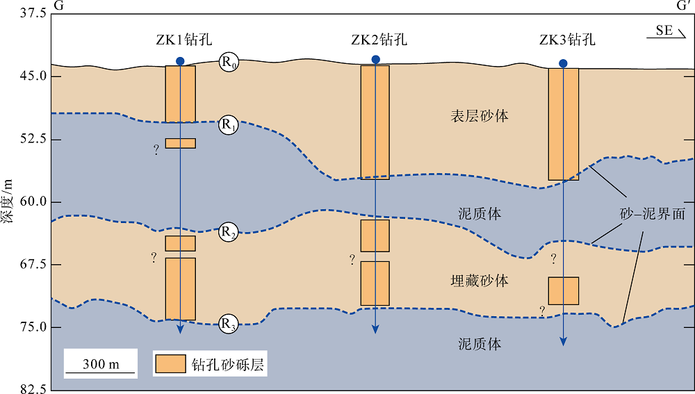
| [1] |
曹欣中, 1985. 浙江近海沿岸上升流与渔场的关系[J]. 海洋湖沼通报, (1):25-28.
|
|
CAO XINZHONG, 1985. On the relationship of the upwelling with fishery off Zhejiang[J]. Transactions of Oceanology and Limnology, (1):25-28 (in Chinese with English abstract).
|
| [2] |
曹雪晴, 谭启新, 张勇, 等, 2007. 中国近海建筑砂矿床特征[J]. 岩石矿物学杂志, 26(2):164-170.
|
|
CAO XUEQING, TAN QIXIN, ZHANG YONG, et al, 2007. Characteristics of construction marine sand deposits in offshore area of China[J]. Acta Petrologica et Mineralogica, 26(2):164-170 (in Chinese with English abstract).
|
| [3] |
杜晓琴, 李炎, 高抒, 2008. 台湾浅滩大型沙波、潮流结构和推移质输运特征[J]. 海洋学报, 30(5):124-136.
|
|
DU XIAOQIN, LI YAN, GAO SHU, 2008. Characteristics of the large-scale sandwaves, tidal flow structure and bedload transport over the Taiwan Bank in southern China[J]. Acta Oceanologica Sinica, 30(5):124-136 (in Chinese with English abstract).
|
| [4] |
冯京, 褚宏宪, 杨源, 等, 2011. 浅地层剖面测量在海砂资源调查中的应用[M]//中国地球物理学会. 中国地球物理·2011. 合肥: 中国科学技术大学出版社: 709.
|
|
FENG JING, ZHU HONGXIAN, YANG YUAN, et al, 2011. Application of subbottom profiler to the investigation of sea sand resources[M]//CHINESE GEOPHYSICAL SOCIETY. The Chinese geophysics. Hefei: University of Science and Technology of China Press: 709 (in Chinese).
|
| [5] |
郭婷婷, 高文洋, 高艺, 等, 2010. 台湾海峡气候特点分析[J]. 海洋预报, 27(1):53-58.
|
|
GUO TINGTING, GAO WENYANG, GAO YI, et al, 2010. An analysis of the climate characteristics for Taiwan Strait[J]. Marine Forecasts, 27(1):53-58 (in Chinese with English abstract).
|
| [6] |
李立, 郭小钢, 吴日升, 2000. 台湾海峡南部的海洋锋[J]. 台湾海峡, 19(2):147-156.
|
|
LI LI, GUO XIAOGANG, WU RISHENG, 2000. Oceanic fronts in southern Taiwan Strait[J]. Journal of Oceanography in Taiwan Strait, 19(2):147-156 (in Chinese with English abstract).
|
| [7] |
李勇航, 单晨晨, 苏明, 等, 2020. 声学水面无人艇在浅水海底地貌调查中的应用[J]. 海洋地质与第四纪地质, 40(6):219-226.
|
|
LI YONGHANG, SHANCHENCHEN, SU MING, et al, 2020. Application of acoustic unmanned surface vehicle to submarine geomorphology survey in shallow water[J]. Marine Geology & Quaternary Geology, 40(6):219-226 (in Chinese with English abstract).
|
| [8] |
刘振夏, 1996. 中国陆架潮流沉积研究新进展[J]. 地球科学进展, 11(4):414-416 (in Chinese).
|
| [9] |
刘振夏, 夏东兴, 2004. 中国近海潮流沉积沙体[M]. 北京: 海洋出版社: 176.
|
|
LIU ZHENXIA, XIA DONGXING, 2004. Tidal sands in the China seas[M]. Beijing: China Ocean Press: 176 (in Chinese).
|
| [10] |
罗昆, 刘刚, 薛玉龙, 等, 2017. 利用单道地震反射数据预测海南岛东部近海砂层分布[J]. 海洋地质与第四纪地质, 37(1):125-130.
|
|
LUO KUN, LIU GANG, XUE YULONG, et al, 2017. Predicting sand-layer distribution in offshore area of eastern Hainan island with single-channel seismic reflection data[J]. Marine Geology & Quaternary Geology, 37(1):125-130 (in Chinese with English abstract).
|
| [11] |
倪玉根, 何健, 习龙, 等, 2019-09-06. 一种盖层海砂泥砂层分界面的物探识别和找砂方法: 中国, 110208855A[P] (in Chinese).
|
| [12] |
倪玉根, 李建国, 习龙, 2021. 海砂粒级划分标准和沉积物命名方法探讨[J]. 热带海洋学报, 40(3):143-151.
|
|
NI YUGEN, LI JIANGUO, XI LONG, 2021. Discussion on grain-size grading scale and sediment classification for marine sand and gravel[J]. Journal of Tropical Oceanography, 40(3):143-151 (in Chinese with English abstract).
|
| [13] |
洪华生, 丘书院, 阮五崎, 等, 1991. 闽南—台湾浅滩渔场上升流区生态系研究概述[M]//闽南—台湾浅滩渔场上升流区生态系研究. 北京: 科学出版社, 1-17(in Chinese).
|
| [14] |
谭启新, 孙岩, 1988. 中国滨海砂矿[M]. 北京: 科学出版社: 100-103(in Chinese).
|
| [15] |
谭启新, 1998. 中国的海洋砂矿[J]. 中国地质, (4):23-26.
|
|
TAN QIXIN, 1998. Marine placer in China[J]. Chinese Geology, (4):23-26 (in Chinese).
|
| [16] |
王圣洁, 刘锡清, 李学杰, 等, 1997. 滨、浅海沉积砂砾石资源的利用潜力[J]. 海洋地质动态, (11):2-4 (in Chinese).
|
| [17] |
张金鹏, 万荣胜, 朱本铎, 2014. 中国近海砂矿资源开发与利用及相关战略建议[J]. 矿床地质, 33(S1):879-880 (in Chinese).
|
| [18] |
赵铁虎, 张训华, 王修田, 等, 2007. 广东珠江口—东平近海浅地层剖面的声学特征及地质意义[J]. 物探化探计算技术, 29(3):183-188.
|
|
ZHAO TIEHU, ZHANG XUNHUA, WANG XIUTIAN, et al, 2007. Sub-bottom profiling (SBP) acoustic characteristics and geological interpretation on offshore from pearl river estuary to Dongping in Guangdong province[J]. Computing Techniques for Geophysical and Geochemical Exploration, 29(3):183-188 (in Chinese with English abstract).
|
| [19] |
赵铁虎, 李军, 张异彪, 等, 2011. 舟山海域海砂资源声地层剖面探测研究[J]. 物探化探计算技术, 33(3):340-345.
|
|
ZHAO TIEHU, LI JUN, ZHANG YIBIAO, et al, 2011. Study of high-resolution SBP exploration for sea sand resources in the Zhoushan offshore[J]. Computing Techniques for Geophysical and Geochemical Exploration, 33(3):340-345 (in Chinese with English abstract).
|
| [20] |
中国地质调查局, 2012. DD2012-10 海砂(建筑用砂)地质勘查规范[S] (in Chinese).
|
| [21] |
ALLEN J R L, 1982. Developments in sedimentology, sedimentary structures their character and physical basis Volume Ⅱ[M]: Amsterdam: Elsevier.
|
| [22] |
BESIO G, Blondeaux P, Vittori G, 2006. On the formation of sand waves and sand banks[J]. Journal of Fluid Mechanics, 557:1-27.
doi: 10.1017/S0022112006009256
|

 ), 贾磊1, 倪玉根1,3, 何健1, 牟泽霖1(