
热带海洋学报 ›› 2022, Vol. 41 ›› Issue (2): 65-76.doi: 10.11978/2021034CSTR: 32234.14.2021034
基于GF-4卫星反演的珠江口水体表层悬浮泥沙时空变化特征*
陈琼1,2( ), 唐世林1,3(), 吴颉1,3
- 1. 热带海洋环境国家重点实验室(中国科学院南海海洋研究所), 广东 广州 510301
2. 中国科学院大学, 北京 100049
3. 南方海洋科学与工程广东省实验室(广州), 广东 广州 511458
-
收稿日期:2021-03-12修回日期:2021-04-20出版日期:2022-03-10发布日期:2021-04-20 -
通讯作者:唐世林 -
作者简介:陈琼(1995—), 女, 硕士研究生, 从事海洋遥感应用研究。email:chenqiong18@mails.ucas.ac.cn -
基金资助:国家自然科学基金(41876207);广东省重大团队项目(2019BT02H594);南方海洋科学与工程广东省实验室(广州)人才团队引进重大专项(GML2019ZD0302)
Spatial-temporal variation of suspended sediment in the Pearl River Estuary retrieved from GF-4 satellite data*
CHEN Qiong1,2(), TANG Shilin1,3(), WU Jie1,3
- 1. State Key Laboratory of Tropical Oceanography (South China Sea Institute of Oceanology, Chinese Academy of Sciences), Guangzhou 510301, China
2. University of Chinese Academy of Sciences, Beijing 100049, China
3. Southern Marine Science and Engineering Guangdong Laboratory (Guangzhou), Guangzhou 511458, China
-
Received:2021-03-12Revised:2021-04-20Online:2022-03-10Published:2021-04-20 -
Contact:TANG Shilin -
Supported by:National Natural Science Foundation of China(41876207);Project from Government of Guangdong Province(2019BT02H594);Key Special Project for Introduced Talents Team of Southern Marine Science and Engineering Guangdong Laboratory (Guangzhou)(GML2019 ZD0302)
摘要:
珠江口伶仃洋是中国重要的海湾之一, 其水体的悬浮泥沙质量浓度(suspended sediment concentration, SSC)在枯季受潮汐过程影响显著, 是研究潮汐对SSC变化影响的理想区域。高分四号卫星(GF-4)是我国第一颗超高时空分辨率地球同步轨道卫星, 可见光波段的空间分辨率为50m, 最大时间分辨率可达20s, 在研究一日之内的SSC变化特征方面具有独特的优势。文章利用过境珠江口伶仃洋的GF-4卫星L1A数据并结合2020年1月的航次数据, 反演得到该海域表层SSC数据, 分析得到了伶仃洋表层SSC在潮汐周期不同阶段的分布特征及变化规律。研究结果表明, 伶仃洋海域的SSC整体呈近岸高于远岸、西岸高于东岸的分布趋势。涨潮时, 共有4个高SSC分布区, 平均SSC呈降低趋势且悬沙有向湾内移动的趋势; 在停潮末—涨急—涨憩过程中, SSC先略微降低后显著降低。落潮时, 共有7个高SSC分布区, 平均SSC呈增长趋势且悬浮泥沙有向外海方向移动的趋势; 在平潮末—落急—落憩过程中, SSC先显著增大再变缓最后呈负增长趋势。SSC变化受水平方向上的挟沙作用、垂直方向上的再悬浮过程和地形的共同影响。
中图分类号:
- P736.211
引用本文
陈琼, 唐世林, 吴颉. 基于GF-4卫星反演的珠江口水体表层悬浮泥沙时空变化特征*[J]. 热带海洋学报, 2022, 41(2): 65-76.
CHEN Qiong, TANG Shilin, WU Jie. Spatial-temporal variation of suspended sediment in the Pearl River Estuary retrieved from GF-4 satellite data*[J]. Journal of Tropical Oceanography, 2022, 41(2): 65-76.
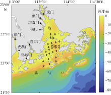
图1
研究区域及悬浮泥沙浓度(SSC)实测数据测量站点位置 该图是基于国家测绘地理信息局标准地图服务网站下载审图号为GS(2016)2924标准地图制作。图中黑色菱形代表2020年1月的航次测站位置, 黑色三角代表珠江八大入海口位置"
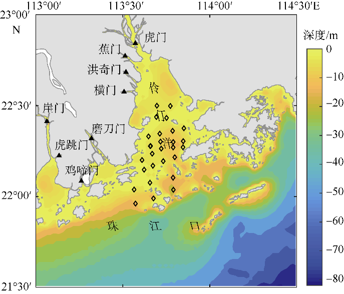
图1
表1
GF-4卫星有效载荷"
| 参数名称 | 波段号 | 波段范围/μm | 空间分辨率/m | 幅宽/km | 重访时间/s |
|---|---|---|---|---|---|
| 可见光近红外(VNIR) | 1 | 0.45~0.90 | 50 | 400 | 20 |
| 2 | 0.45~0.52 | 50 | |||
| 3 | 0.52~0.60 | 50 | |||
| 4 | 0.63~0.69 | 50 | |||
| 5 | 0.76~0.90 | 50 | |||
| 中波红外(MWIR) | 6 | 3.50~4.10 | 400 |
表1
表2
2020年GF-4卫星绝对辐射定标系数和大气层外波段太阳辐照度"
| 参数名称 | Panchromatic Band | Band 1 | Band 2 | Band 3 | Band 4 |
|---|---|---|---|---|---|
| 绝对定标系数增益值 | 0.1266 | 0.1858 | 0.2013 | 0.1580 | 0.1087 |
| 绝对定标系数偏移值 | 0 | 0 | 0 | 0 | 0 |
| 太阳辐照度/(W•m-2•μm-1) | 1609.798 | 1929.556 | 1839.332 | 1578.125 | 1104.766 |
表2
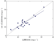
图2
遥感反演与实测悬浮泥沙质量浓度(SSC)的验证结果 图中黑色虚线表示1:1关系, 蓝色实线表示反演SCC和实测SSC的线性拟合情况, 蓝色三角代表样本点数据"
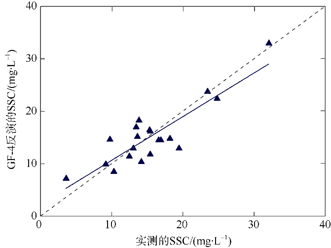
图2
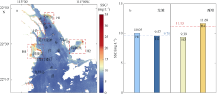
图3
2021年2月21日珠江口伶仃洋涨潮时3景遥感影像反演的平均悬浮泥沙浓度(SSC)分布情况 a. 高SSC区的分布范围。图中红色虚线方框代表SSC高值区的分布范围, 其中H1 (113°42′—113°47′E, 22°40′—22°45′N), H2 (113°54′—114°00′E, 22°24′—22°33′N), H3 (113°38′—113°42′E, 22°33′—22°37′N), H4 (113°33′E—113°40′E, 22°23′N—22°30′N); b. 珠江口伶仃洋东、西滩各高SCC区的平均SSC直方图。蓝色和红色虚线分别代表东滩和西滩的平均SSC"
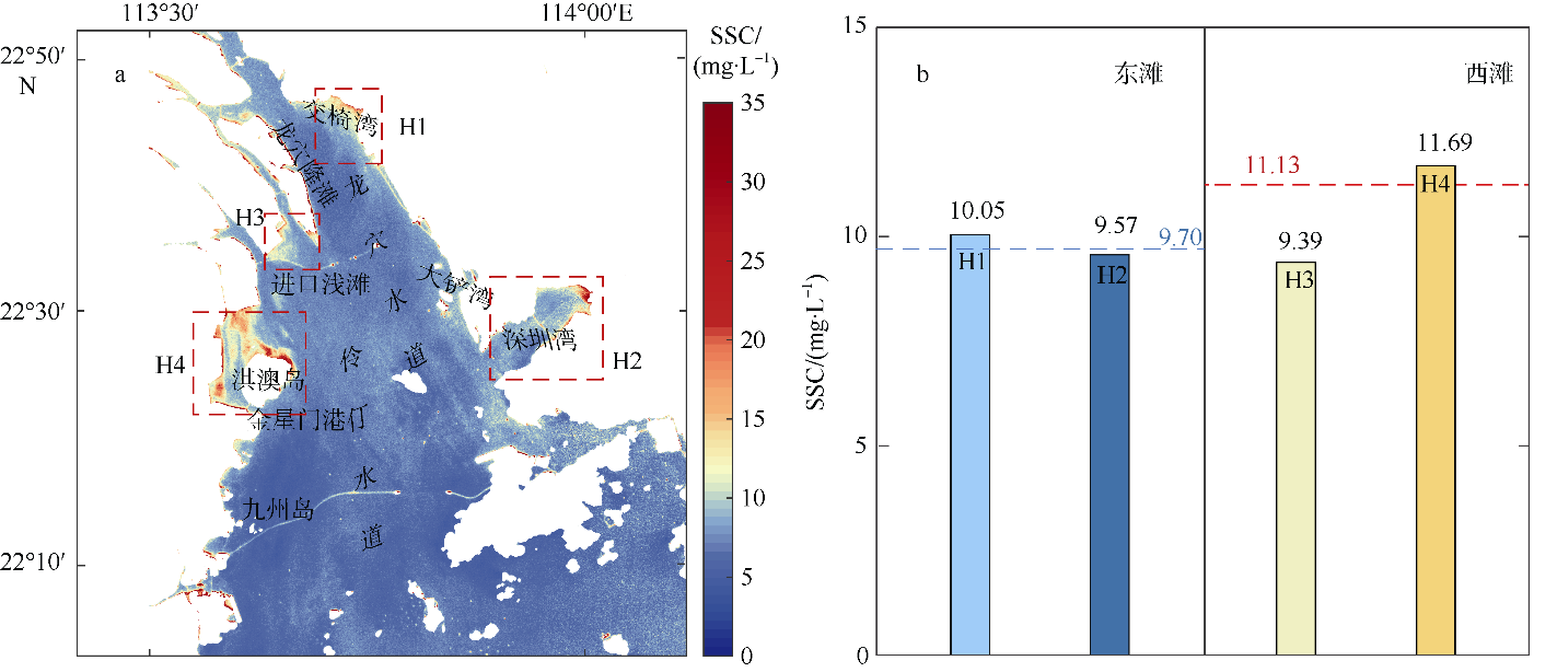
图3

图4
2020年12月28日珠江口伶仃洋落潮时3景遥感影像反演的平均悬浮泥沙质量浓度(SSC)分布情况 a. 高SSC区的分布范围。图中红色虚线方框代表SSC高值区的分布范围, 其中H1 (113°42′—113°47′E, 22°40′—22°45′N), H2 (113°54′—114°00′E, 22°24′—22°33′N), H3 (113°38′—113°42′E, 22°33′—22°37′N), H4 (113°33′E—113°40′E, 22°23′N—22°30′N), H5 (113°39′—113°44′E, 22°30′—22°35′N), H6 (113°33′—113°41′E, 22°23′—22°30′N), H7 (113°35′—113°42′E, 22°15′—22°23′N); b. 珠江口伶仃洋东西滩各高SCC区的平均SSC直方图。蓝色和红色虚线分别代表东滩和西滩的平均SSC"
图4
图5
2021年2月21日珠江口伶仃洋涨潮不同时刻遥感影像反演的悬浮泥沙质量浓度(SSC)分布及变化情况 a. 停潮末(10:40:06); b. 涨急(14:00:06); c. 涨憩(16:34:57); d. 涨憩与停潮末期的平均SSC差值。图中数字为该海域平均悬浮泥沙浓度"

图5
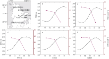
图6
2021年2月21日珠江口伶仃洋内的各验潮站在涨潮不同阶段的悬浮泥沙质量浓度(SSC)变化情况 a. 验潮站位置示意图, 基于国家测绘地理信息局标准地图服务网站下载审图号为GS(2016)2924的标准地图制作; b. 舢板洲验潮站; c. 深圳机场验潮站; d. 蛇口(赤湾)验潮站; e. 内伶仃岛验潮站; f. 珠海(香洲)验潮站"
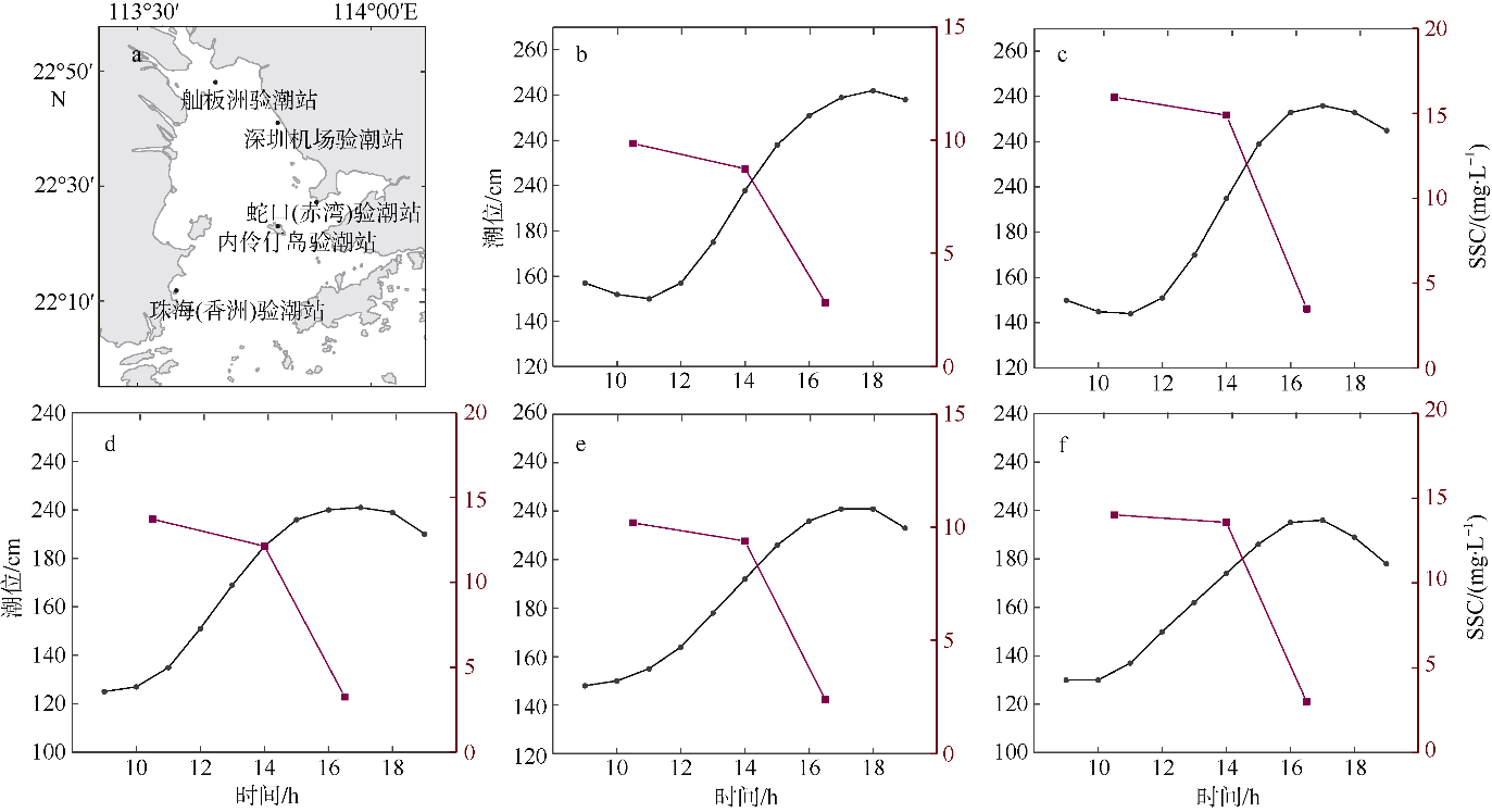
图6
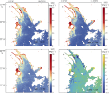
图7
2020年12月28日珠江口伶仃洋落潮不同时刻遥感影像反演的悬浮泥沙浓度(SSC)分布及变化情况 a. 平潮末(10:43:38); b. 落急(12:43:38); c. 落憩(13:33:38); d. 落憩与平潮末期的平均SSC差值。图中数字为该海域平均悬浮泥沙浓度值"
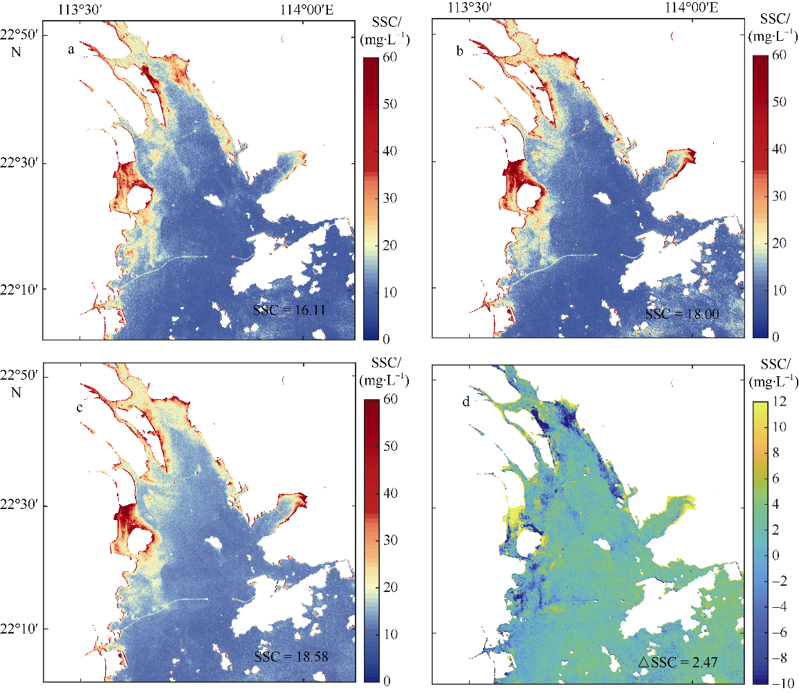
图7
图8
2020年12月28日珠江口伶仃洋内的各验潮站在落潮不同阶段的悬浮泥沙质量浓度(SSC)变化情况 a. 验潮站位置示意图, 基于国家测绘地理信息局标准地图服务网站下载审图号为GS(2016)2924的标准地图制作; b. 舢板洲验潮站; c. 深圳机场验潮站; d. 蛇口(赤湾)验潮站; e. 内伶仃岛验潮站; f. 珠海(香洲)验潮站"
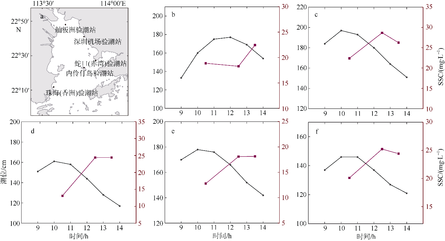
图8
| [1] | 陈晓玲, 袁中智, 李毓湘, 等, 2005. 基于遥感反演结果的悬浮泥沙时空动态规律研究--以珠江河口及邻近海域为例[J]. 武汉大学学报信息科学版, 30(8): 677-681. |
| CHEN XIAOLING, YUAN ZHONGZHI, LI YUXIANG, et al, 2005. Spatial and temporal dynamics of suspended sediment concentration in the Pearl River estuary based on remote sensing[J]. Geomatics and Information Science of Wuhan University, 30(8): 677-681. (in Chinese with English abstract) | |
| [2] | 国家海洋信息中心, 2020. 潮汐表(第3册): 台湾海峡至北部湾[M]. 北京: 海洋出版社. |
| NATIONAL MARINE DATA AND INFORMATION SERVICE, 2020. Tide tables (Vol. 3): from the Taiwan Straits to the Beibu Gulf[M]. Beijing: Ocean Press. (in Chinese) | |
| [3] |
李春初, 1997. 论河口体系及其自动调整作用--以华南河流为例[J]. 地理学报, 52(4): 353-360.
doi: 10.11821/xb199704009 |
|
LI CHUNCHU, 1997. On the estuarine system and its automatic adjustment[J]. Acta Geographica Sinica, 52(4): 353-360. (in Chinese with English abstract)
doi: 10.11821/xb199704009 |
|
| [4] | 刘大召, 李卓, 陈仔豪, 等, 2020. 基于高分1号遥感数据港珠澳大桥对珠江口海域悬浮泥沙分布的影响[J]. 广东海洋大学学报, 40(6): 89-95. |
| LIU DAZHAO, LI ZHUO, CHEN ZIHAO, et al, 2020. Influence of Hong Kong-Zhuhai-Macao bridge on the distribution of suspended sediment in the Pearl River Estuary[J]. Journal of Guangdong Ocean University, 40(6): 89-95. (in Chinese with English abstract) | |
| [5] | 刘汾汾, 陈楚群, 唐世林, 等, 2009. 基于现场光谱数据的珠江口MERIS悬浮泥沙分段算法[J]. 热带海洋学报, 28(1): 9-14. |
| LIU FENFEN, CHEN CHUQUN, TANG SHILIN, et al, 2009. A piecewise algorithm for retrieval of suspended sediment concentration based on in situ spectral data by MERIS in Zhujiang River Estuary[J]. Journal of Tropical Oceanography, 28(1): 9-14. (in Chinese with English abstract) | |
| [6] | 刘凤晶, 李果, 于登云, 等, 2018. 高分四号卫星及应用概况[J]. 卫星应用, (12): 12-18. (in Chinese) |
| [7] | 栾虹, 付东洋, 李明杰, 等, 2017. 基于Landsat 8珠江口悬浮泥沙四季遥感反演与分析[J]. 海洋环境科学, 36(6): 892-897. |
| LUAN HONG, FU DONGYANG, LI MINGJIE, et al, 2017. Based on Landsat 8 suspended sediment concentration of the Pearl River on each season inversion and analysis[J]. Marine Environmental Science, 36(6): 892-897. (in Chinese with English abstract) | |
| [8] | 谢梅芳, 张萍, 杨昊, 等, 2021. 珠江“伶仃洋河口湾-虎门-潮汐通道”的潮波传播特征[J]. 热带海洋学报, 40(4): 1-13. |
| XIE MEIFANG, ZHANG PING, YANG HAO, et al, 2021. Tidal wave propagation dynamics in “Lingdingyang Bay-Humen outlet-tidal channel” of the Pearl River[J]. Journal of Tropical Oceanography, 40(4): 1-13. (in Chinese with English abstract) | |
| [9] | 詹伟康, 吴颉, 韦惺, 等, 2019. 基于遥感反演的珠江河口表层悬沙浓度分位数趋势分析[J]. 热带海洋学报, 38(3): 32-42. |
| ZHAN WEIKANG, WU JIE, WEI XING, et al, 2019. Quantile trend analysis for suspended sediment concentration in the Pearl River Estuary based on remote sensing[J]. Journal of Tropical Oceanography, 38(3): 32-42. (in Chinese with English abstract) | |
| [10] | 朱樊, 欧素英, 张铄涵, 等, 2015. 基于MODIS影像的珠江口表层悬沙浓度反演及时空变化分析[J]. 泥沙研究, (2): 67-73. |
| ZHU FAN, OU SUYING, ZHANG SHUOHAN, et al, 2015. MODIS images-based retrieval and analysis of spatial-temporal change of superficial suspended sediment concentration in the Pearl River Estuary[J]. Journal of Sediment Research, (2): 67-73. (in Chinese with English abstract) | |
| [11] |
AHMAD Z, FRANZ B A, MCCLAIN C R, et al, 2010. New aerosol models for the retrieval of aerosol optical thickness and normalized water-leaving radiances from the SeaWiFS and MODIS sensors over coastal regions and open oceans[J]. Applied Optics, 49(29): 5545-5560.
doi: 10.1364/AO.49.005545 |
| [12] |
AMANTE C, EAKINS B W, 2009. ETOPO 1 1 Arc-minute global relief model: procedures, data sources and analysis[Z]. Boulder: NOAA, doi: 10.7289/V5C8276M.
doi: 10.7289/V5C8276M |
| [13] |
CHAMI M, LARNICOL M, MIGEON S, et al, 2020. Potential for nocturnal satellite detection of suspended matter concentrations in coastal waters using a panchromatic band: a feasibility study based on VIIRS (NASA/NOAA) spectral and radiometric specifications[J]. Optics Express, 28(10): 15314-15330.
doi: 10.1364/OE.393048 |
| [14] |
CHEN XIAOHONG, CHEN YONGQIN, LAI GUOYOU, 2005. Modeling transportation of suspended solids in Zhujiang River estuary, South China[J]. Chinese Journal of Oceanology and Limnology, 23(1): 1-10.
doi: 10.1007/BF02845136 |
| [15] |
CHENG ZHIXIN, WANG XIAOHUA, PAULL D, et al, 2016. Application of the geostationary ocean color imager to mapping the diurnal and seasonal variability of surface suspended matter in a Macro-Tidal Estuary[J]. Remote Sensing, 8(3): 244.
doi: 10.3390/rs8030244 |
| [16] |
GORDON H R,WANG MENGHUA, 1994. Retrieval of water-leaving radiance and aerosol optical thickness over the Oceans with SeaWiFs: a preliminary algorithm[J]. Applied Optics, 33(3): 443-452.
doi: 10.1364/AO.33.000443 |
| [17] |
HE QUANJUN, CHEN CHUQUAN, 2014. A new approach for atmospheric correction of MODIS imagery in turbid coastal waters: a case study for the Pearl River Estuary[J]. Remote Sensing Letters, 5(3): 249-257.
doi: 10.1080/2150704X.2014.898192 |
| [18] |
HE XIANQIANG, BAI YAN, PAN DELU, et al, 2013. Using geostationary satellite ocean color data to map the diurnal dynamics of suspended particulate matter in coastal waters[J]. Remote Sensing of Environment, 133: 225-239.
doi: 10.1016/j.rse.2013.01.023 |
| [19] |
HU YUEKAI, YU ZHIFENG, ZHOU BIN, et al, 2019. Tidal- driven variation of suspended sediment in Hangzhou Bay based on GOCI data[J]. International Journal of Applied Earth Observation and Geoinformation, 82: 101920.
doi: 10.1016/j.jag.2019.101920 |
| [20] | JIANG SIYI, XU FANGJIAN, LI YAN, et al, 2014. Distributional characteristics of grain sizes of surface sediments in the Zhujiang River Estuary[J]. Acta Oceanologica Sinica, 33(4): 30-36. |
| [21] | LI FENG, FU JIE, XIN LEI, et al, 2017. New developments in super-resolution for GaoFen-4[C]// Proceedings of SPIE 10427, image and signal processing for remote sensing ⅩⅩⅢ. Warsaw: SPIE. |
| [22] |
LI FENG, XIN LEI, GUO YI, et al, 2018. Super-Resolution for GaoFen-4 remote sensing images[J]. IEEE Geoscience and Remote Sensing Letters, 15(1): 28-32.
doi: 10.1109/LGRS.2017.2768331 |
| [23] |
LI PENG, KE YINGHAI, BAI JUNHONG, et al, 2019. Spatiotemporal dynamics of suspended particulate matter in the Yellow River Estuary, China during the past two decades based on time-series Landsat and Sentinel-2 data[J]. Marine Pollution Bulletin, 149: 110518.
doi: 10.1016/j.marpolbul.2019.110518 |
| [24] | LI ZHANHAI, LI M Z, DAI ZHIJUN, et al, 2015. Intratidal and neap-spring variations of suspended sediment concentrations and sediment transport processes in the North Branch of the Changjiang Estuary[J]. Acta Oceanologica Sinica, 34(1): 137-147. |
| [25] | LIAO YINGDI, ZHANG WEI, CHEN DA, 2010. A study on the quantitative model of surface suspended sediment concentration in Yangtze estuary from seaWiFS data[J]. IEEE. |
| [26] |
LIU FENFEN, ZHANG TONGHUI, YE HAIBIN, et al, 2021. Using satellite remote sensing to study the effect of sand excavation on the suspended sediment in the Hong Kong-Zhuhai-Macau Bridge Region[J]. Water, 13(4): 435.
doi: 10.3390/w13040435 |
| [27] | LIU GUANGPING, CAI SHUQUN, 2019. Modeling of suspended sediment by coupled wave-current model in the Zhujiang (Pearl) River Estuary[J]. Acta Oceanologica Sinica, 38(7): 22-35. |
| [28] |
LIU JIA, LIU JIAHANG, HE XIANQIANG, et al, 2018. Diurnal dynamics and seasonal variations of total suspended particulate matter in highly turbid Hangzhou Bay waters based on the geostationary ocean color imager[J]. IEEE Journal of Selected Topics in Applied Earth Observations and Remote Sensing, 11(7): 2170-2180.
doi: 10.1109/JSTARS.4609443 |
| [29] | LIU RUNQI, WANG YAPING, GAO JIANHUA, et al, 2016. Turbidity maximum formation and its seasonal variations in the Zhujiang (Pearl River) Estuary, southern China[J]. Acta Oceanologica Sinica, 35(8): 22-31. |
| [30] | MAYO M, KARNIELI A, GITELSON A, et al, 1993. Determination of suspended sediment concentrations from CZCS data[J]. Photogrammetric Engineering and Remote Sensing, 59(8): 1265-1269. |
| [31] | OU SUYING, YANG QINGSHU, LUO XIANGXIN, et al, 2019. The influence of runoff and wind on the dispersion patterns of suspended sediment in the Zhujiang (Pearl) River Estuary based on MODIS data[J]. Acta Oceanologica Sinica, 38(3): 26-35. |
| [32] |
RUDDICK K G, OVIDIO F, RIJKEBOER M, 2000. Atmospheric correction of SeaWiFS imagery for turbid coastal and inland waters[J]. Applied Optics, 39(6): 897-912.
doi: 10.1364/AO.39.000897 |
| [33] |
SCANES P, COADE G, DOHERTY M, et al, 2007. Evaluation of the utility of water quality based indicators of estuarine lagoon condition in NSW, Australia[J]. Estuarine, Coastal and Shelf Science, 74(1-2): 306-319.
doi: 10.1016/j.ecss.2007.04.021 |
| [34] |
SIEGEL D A, WANG M H, MARITORENA S, et al, 2000. Atmospheric correction of satellite ocean color imagery: the black pixel assumption[J]. Applied Optics, 39(21): 3582-3591.
doi: 10.1364/AO.39.003582 |
| [35] |
TANG SHILIN, LAROUCHE P, NIEMI A, et al, 2013. Regional algorithms for remote-sensing estimates of total suspended matter in the Beaufort Sea[J]. International Journal of Remote Sensing, 34(19): 6562-6576.
doi: 10.1080/01431161.2013.804222 |
| [36] |
TIAN LIQIAO, WAI O W H, CHEN XIAOLING, et al, 2016. Retrieval of total suspended matter concentration from Gaofen-1 Wide Field Imager (WFI) multispectral imagery with the assistance of Terra MODIS in turbid water-case in Deep Bay[J]. International Journal of Remote Sensing, 37(14): 3400-3413.
doi: 10.1080/01431161.2016.1199084 |
| [37] |
TOMING K, KUTSER T, UIBOUPIN R, et al, 2017. Mapping water quality parameters with sentinel-3 ocean and land colour instrument imagery in the Baltic Sea[J]. Remote Sensing, 9(10): 1070.
doi: 10.3390/rs9101070 |
| [38] | WANG DIANZHONG, HE HONGYAN, 2017. Observation capability and application prospect of GF-4 satellite[M]// ZHANGGUANGJUN. 3rd international symposium of space optical instruments and applications. Cham: Springer: 393-401. |
| [39] |
WANG FAN, ZHOU BIN, LIU XINGMEI, et al, 2012. Remote-sensing inversion model of surface water suspended sediment concentration based on in situ measured spectrum in Hangzhou Bay, China[J]. Environmental Earth Sciences, 67(6): 1669-1677.
doi: 10.1007/s12665-012-1608-0 |
| [40] |
WANG MENGHUA, SHI WEI, 2007. The NIR-SWIR combined atmospheric correction approach for MODIS ocean color data processing[J]. Optics Express, 15(24): 15722-15733.
doi: 10.1364/OE.15.015722 |
| [41] |
WU JIE, CHEN CHUQUN, NUKAPOTHULA S, 2019. Atmospheric correction of GOCI using quasi-synchronous VIIRS data in highly turbid coastal waters[J]. Remote Sensing, 12(1): 89.
doi: 10.3390/rs12010089 |
| [42] |
XIONG JILIAN, WANG XIAOHUA, WANG YAPING, et al, 2017. Mechanisms of maintaining high suspended sediment concentration over tide-dominated offshore shoals in the southern Yellow Sea[J]. Estuarine, Coastal and Shelf Science, 191: 221-233.
doi: 10.1016/j.ecss.2017.04.023 |
| [43] |
YE HAIBIN, CHEN CHUQUN, YANG CHAOYU, 2017. Atmospheric correction of landsat-8/OLI imagery in turbid estuarine waters: a case study for the pearl river estuary[J]. IEEE Journal of Selected Topics in Applied Earth Observations and Remote Sensing, 10(1): 252-261.
doi: 10.1109/JSTARS.4609443 |
| [44] |
YEPEZ S, LARAQUE A, MARTINEZ J M, et al, 2018. Retrieval of suspended sediment concentrations using Landsat-8 OLI satellite images in the Orinoco River (Venezuela)[J]. Comptes Rendus Geoscience, 350(1-2): 20-30.
doi: 10.1016/j.crte.2017.08.004 |
| [45] |
YU QIAN, WANG YAPING, FLEMMING B, et al, 2012. Tide-induced suspended sediment transport: depth-averaged concentrations and horizontal residual fluxes[J]. Continental Shelf Research, 34: 53-63.
doi: 10.1016/j.csr.2011.11.015 |
| [46] |
ZENG XIANGMING, HE RUOYING, XUE ZUO, et al, 2015. River-derived sediment suspension and transport in the Bohai, Yellow, and East China Seas: A preliminary modeling study[J]. Continental Shelf Research, 111: 112-125.
doi: 10.1016/j.csr.2015.08.015 |
| [47] |
ZIEGLER C K, LICK W, 1988. The transport of fine-grained sediments in shallow waters[J]. Environmental Geology and Water Sciences, 11(1): 123-132.
doi: 10.1007/BF02587771 |
| [1] | 缪予晴, 徐海明, 刘佳伟. 西北太平洋夏季海洋热浪的变化特征及海气关系[J]. 热带海洋学报, 2021, 40(1): 31-43. |
| [2] | 王天宇, 杜岩, 夏一凡. 基于拉格朗日方法的南海自动剖面浮标轨迹模拟系统*[J]. 热带海洋学报, 2018, 37(4): 9-9. |
| [3] | 冯兴如, 李近元, 尹宝树, 杨德周, 陈海英, 高冠东. 海南东方近岸海域海浪观测特征研究[J]. 热带海洋学报, 2018, 37(3): 1-8. |
| [4] | 李付成, 孙珍, 张江阳. 海山俯冲过程中的变形特征——物理模拟和数值模拟证据[J]. 热带海洋学报, 2016, 35(1): 31-37. |
| [5] | 郑兆勇,周雄,江四义,蔺明霞,游大伟,吕柏明. 近50年华南沿海SST热事件变化的时空特征[J]. 热带海洋学报, 2010, 29(4): 14-19. |
|
||