
西沙群岛珊瑚礁2015—2023年间海岸地貌演化与其区域海洋环境特征的关联性研究
|
赵中伟(1992—), 男, 新疆维吾尔自治区乌鲁木齐市人, 副研究员, 博士, 从事海岛海岸地貌研究。email: zhongwei.zhao@scsio.ac.cn |
Copy editor: 孙翠慈
收稿日期: 2024-03-26
修回日期: 2024-04-18
网络出版日期: 2024-05-31
基金资助
国家自然科学基金(42206216)
中国科学院广州分院院长青年人才基金(2023000352)
A study of the correlation between coastal morphological changes and oceanographic conditions of coral reef islands in the Xisha Islands from 2015 to 2023
Received date: 2024-03-26
Revised date: 2024-04-18
Online published: 2024-05-31
Supported by
National Natural Science Foundation of China(42206216)
Youth Talent Fund of the President of Chinese Academy of Sciences Guangzhou Branch(2023000352)
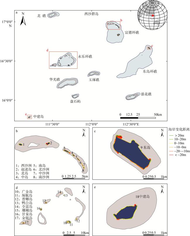
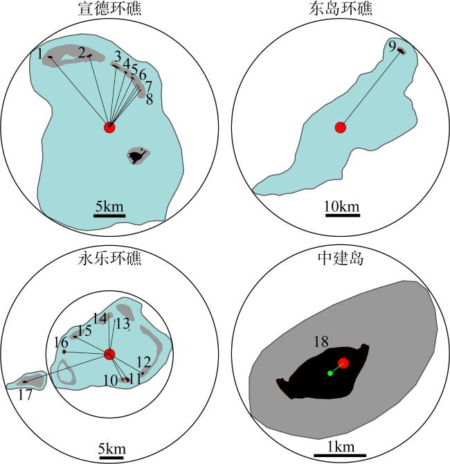
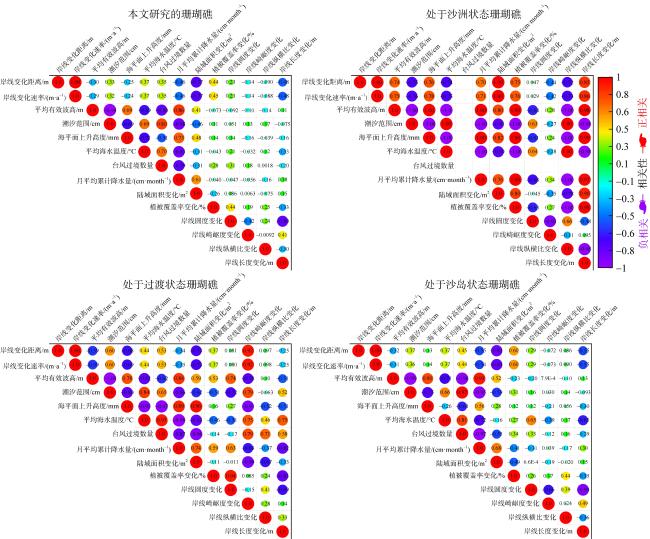
西沙群岛地处海南岛到南海诸岛的中心位置, 是构造和生物交互作用形成的典型地质地貌体, 但西沙群岛又地处南海典型气候脆弱区, 是我国遭受台风、风暴潮等极端海洋灾害影响最严重的区域之一。未来推进西沙群岛的岛礁资源高质量发展, 势必会扩大西沙珊瑚礁海岸的使用规模, 加上全球气候日益恶化多重威胁所加重的海洋环境灾害风险, 使得西沙群岛珊瑚礁海岸的海洋防灾减灾面临更加严峻的挑战。因此, 揭示珊瑚礁海岸对于海洋环境的地貌响应, 就成为了厘清珊瑚礁在未来海洋环境影响下的生存前景和经略海洋可持续性所迫切需要解决的关键问题。所以, 本文选取西沙群岛的18个珊瑚礁作为研究对象, 利用海洋卫星遥感数据获取了它们在2015和2023年的海岸地貌影像, 通过海洋地质和海岸地貌理论分析了珊瑚礁海岸地貌的演化特征, 利用物理海洋分析方法刻画了它们所处海域的海洋环境特征, 尝试利用海洋环境特征解释其海岸地貌演化空间差异性的原因。关联性分析结果表明这些珊瑚礁海岸地貌演化与其区域海洋环境特征之间强关联性较弱(R2仅在0.06~0.21区间)。因此本文建议未来在科学评判西沙珊瑚礁在全球海洋环境变化下的生存前景时, 需要在综合考虑海洋环境要素的基础上, 加强对珊瑚礁所处地貌演化阶段、原始地形地貌、沉积动力过程、生物种群类型等影响作用的考量。
赵中伟 , 赵璇 , 陈天然 , 李伟 . 西沙群岛珊瑚礁2015—2023年间海岸地貌演化与其区域海洋环境特征的关联性研究[J]. 热带海洋学报, 2025 , 44(4) : 25 -44 . DOI: 10.11978/2024070
The Xisha Islands are located on the central route from the Hainan Island to other oceanic islands in the South China Sea (SCS). They are typical geological and geomorphological complexes formed by the coupling interaction between tectonic and biological processes. However, their exposed area is also within a typical climate-vulnerable zone of SCS, being severely influenced by extreme marine hazards, e.g., typhoons and storm surges. Coral reef coastal areas are anticipated to be broadly developed in the future, following the strategy of high-quality development of reef island resources in the Xisha Islands. With increasing risks and threats from marine environmental disasters due to global climate change, the challenges of marine hazards prevention and mitigation in the Xisha Islands are further heightened. Hence, revealing the geomorphic response of coral reef coasts to marine environments becomes a critical issue that urgently needs to be addressed. Therefore, this study employs 18 coral reefs in the Xisha Islands as their research subjects, using marine satellite remote sensing data to acquire their coastal geomorphology images in 2015 and 2023. Morphological changes of these coral reef coasts are characterized based upon marine geology and coastal geomorphology theories, while surrounding marine environmental conditions are examined using physical oceanographic analysis methods. This study attempts to link the spatial difference of coastal morphological change among reef islands to environmental conditions. Coupled analysis demonstrates only a weak correlation (R2 ranging from 0.06 to 0.21) between the coastal morphological difference of these coral reefs and their regional marine environmental characteristics. Therefore, to scientifically assess the survival prospects of coral reefs in the Xisha Islands under the influence of global marine environmental changes, this work suggests the need to (1) comprehensively consider multiple marine environmental characteristics, and (2) strengthen the evaluation of their morphological evolution status, original geomorphology, sedimentary dynamics processes and the impact of marine biota of coral reefs.
Key words: Xisha Islands; coral reefs; coastline change; marine remote sensing; global change
表1 本文所研究西沙群岛珊瑚礁的卫星遥感影像信息Tab. 1 Satellite remote sensing image information of the coral reefs in the Xisha Islands studied in this paper |
| 序号 | 珊瑚礁 | 卫星源 | 开始卫星 影像时间 | 潮汐 水位/cm | 结束卫星 影像时间 | 时间 间隔/a | 潮汐 水位/cm | 备注 | 地貌演 化阶段 | 礁盘 类型 | 相对位置 | 距离礁盘中心距离/km |
|---|---|---|---|---|---|---|---|---|---|---|---|---|
| 1 | 西沙洲 | 哨兵-2号 | 2015-11-22 | 154 | 2023-11-10 | 8 | 150 | 低人类活动影响 | 过渡 | 环礁 | 环礁北部 | 14.64 |
| 2 | 赵述岛 | 哨兵-2号 | 2015-11-22 | 154 | 2023-12-15 | 8.07 | 162 | 高人类活动影响 | 沙岛 | 环礁 | 环礁北部 | 11.67 |
| 3 | 北岛 | 哨兵-2号 | 2015-11-22 | 154 | 2023-12-15 | 8.07 | 162 | 低人类活动影响 | 沙岛 | 环礁 | 环礁东北部 | 9.70 |
| 4 | 中岛 | 哨兵-2号 | 2015-11-22 | 154 | 2023-12-15 | 8.07 | 162 | 低人类活动影响 | 沙岛 | 环礁 | 环礁东北部 | 9.01 |
| 5 | 南岛 | 哨兵-2号 | 2015-11-22 | 154 | 2023-12-15 | 8.07 | 162 | 低人类活动影响 | 沙岛 | 环礁 | 环礁东北部 | 8.65 |
| 6 | 北沙洲 | 哨兵-2号 | 2015-11-22 | 154 | 2023-12-15 | 8.07 | 162 | 低人类活动影响 | 沙洲 | 环礁 | 环礁东北部 | 8.27 |
| 7 | 中沙洲 | 哨兵-2号 | 2015-11-22 | 154 | 2023-12-15 | 8.07 | 162 | 低人类活动影响 | 沙洲 | 环礁 | 环礁东北部 | 8.02 |
| 8 | 南沙洲 | 哨兵-2号 | 2015-11-22 | 154 | 2023-12-15 | 8.07 | 162 | 低人类活动影响 | 过渡 | 环礁 | 环礁东北部 | 7.69 |
| 9 | 东岛 | 哨兵-2号 | 2015-11-23 | 159 | 2023-12-30 | 8.11 | 157 | 高人类活动影响 | 沙岛 | 环礁 | 环礁东北部 | 28.72 |
| 10 | 广金岛 | 哨兵-2号 | 2015-11-22 | 169 | 2023-11-10 | 7.89 | 150 | 高人类活动影响 | 沙岛 | 环礁 | 环礁东南部 | 6.01 |
| 11 | 琛航岛 | 哨兵-2号 | 2015-11-22 | 169 | 2023-11-10 | 7.89 | 150 | 高人类活动影响 | 沙岛 | 环礁 | 环礁东南部 | 6.50 |
| 12 | 晋卿岛 | 哨兵-2号 | 2015-11-22 | 169 | 2023-11-10 | 7.89 | 150 | 低人类活动影响 | 沙岛 | 环礁 | 环礁东南部 | 8.13 |
| 13 | 鸭公岛 | 哨兵-2号 | 2015-11-22 | 169 | 2023-11-10 | 7.89 | 150 | 低人类活动影响 | 过渡 | 环礁 | 环礁北部 | 7.40 |
| 14 | 全富岛 | 哨兵-2号 | 2015-11-22 | 154 | 2023-11-10 | 7.97 | 150 | 低人类活动影响 | 沙洲 | 环礁 | 环礁北部 | 8.20 |
| 15 | 珊瑚岛 | 哨兵-2号 | 2015-11-22 | 169 | 2023-11-10 | 7.89 | 150 | 高人类活动影响 | 沙岛 | 环礁 | 环礁西部 | 8.22 |
| 16 | 甘泉岛 | 哨兵-2号 | 2015-11-22 | 169 | 2023-11-10 | 7.89 | 150 | 低人类活动影响 | 沙岛 | 环礁 | 环礁西部 | 9.64 |
| 17 | 金银岛 | 哨兵-2号 | 2015-11-22 | 169 | 2023-11-10 | 7.89 | 150 | 高人类活动影响 | 沙岛 | 环礁 | 环礁西南部 | 18.96 |
| 18 | 中建岛 | 哨兵-2号 | 2015-11-22 | 154 | 2023-11-10 | 7.97 | 150 | 高人类活动影响 | 过渡 | 台礁 | 台礁西南部 | 0.32 |
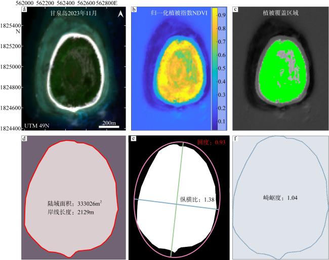
图3 珊瑚礁海岸地貌分析示意图, 以甘泉岛为例a. 卫星遥感原始影像; b. 归一化植被指数计算分析图; c. 植被覆盖区域识别图; d. 岸线长度及所围陆域面积计算结果图; e. 岸线圆度及纵横比分析结果图; f. 岸线崎岖度分析结果图 Fig. 3 Schematic diagram of coral reef coastal geomorphology analysis, taking Ganquan Reef as an example. (a) Original satellite remote sensing image; (b) result of calculated normalized difference vegetation index (NDVI); (c) identified vegetation coverage area map; (d) analysis results of interpreted coastline length and the subaerial area of reef island; (e) analysis results of circularity and the ratio between major and minor axis; (f) analysis results of fractal dimension calculated for coral reef coastline |
表2 珊瑚礁2015年和2023年的海岸地貌特征汇总Tab. 2 Summary of coastal geomorphological characteristics of studied reef islands’ coasts in 2015 and 2023 |
| 序号 | 珊瑚礁 | 2015年(初始特征) | 2023年(结束特征) | |||||||||||
|---|---|---|---|---|---|---|---|---|---|---|---|---|---|---|
| 岸线 长度/m | 陆域 面积/m2 | 植被 覆盖率/% | 岸线 圆度 | 岸线 崎岖度 | 岸线 纵横比 | 岸线 长度/m | 陆域 面积/m2 | 植被 覆盖率/% | 岸线 圆度 | 岸线 崎岖度 | 岸线 纵横比 | |||
| 1 | 西沙洲 | 2067 | 248449 | 5.70 | 0.73 | 1.04 | 2.13 | 1958 | 237631 | 79.18 | 0.78 | 1.03 | 2.15 | |
| 2 | 赵述岛 | 2617 | 274184 | 54.80 | 0.50 | 1.05 | 2.38 | 3480 | 313006 | 80.77 | 0.33 | 1.07 | 2.09 | |
| 3 | 北岛 | 3285 | 310352 | 76.92 | 0.36 | 1.06 | 5.45 | 3633 | 363736 | 73.83 | 0.34 | 1.06 | 5.98 | |
| 4 | 中岛 | 1476 | 126008 | 76.41 | 0.73 | 1.02 | 2.50 | 1572 | 129608 | 74.98 | 0.66 | 1.03 | 2.55 | |
| 5 | 南岛 | 1924 | 116708 | 61.61 | 0.40 | 1.04 | 5.18 | 1952 | 125018 | 65.52 | 0.41 | 1.04 | 4.80 | |
| 6 | 北沙洲 | 573 | 14755 | 25.99 | 0.57 | 1.04 | 2.57 | 669 | 17359 | 26.38 | 0.49 | 1.05 | 2.67 | |
| 7 | 中沙洲 | 1030 | 41555 | 21.74 | 0.50 | 1.06 | 2.05 | 1143 | 46962 | 22.16 | 0.45 | 1.05 | 2.16 | |
| 8 | 南沙洲 | 1390 | 62475 | 57.35 | 0.41 | 1.07 | 1.22 | 1422 | 64514 | 55.62 | 0.40 | 1.05 | 1.27 | |
| 9 | 东岛 | 7173 | 1812191 | 85.57 | 0.44 | 1.06 | 2.53 | 6709 | 1896497 | 85.94 | 0.53 | 1.04 | 2.57 | |
| 10 | 广金岛 | 2888 | 180019 | 22.19 | 0.27 | 1.08 | 1.99 | 2452 | 163203 | 86.67 | 0.34 | 1.09 | 2.53 | |
| 11 | 琛航岛 | 3510 | 580377 | 14.15 | 0.58 | 1.04 | 1.78 | 3459 | 574393 | 79.29 | 0.61 | 1.04 | 1.80 | |
| 12 | 晋卿岛 | 2044 | 216709 | 83.57 | 0.65 | 1.04 | 2.44 | 2121 | 218584 | 82.59 | 0.61 | 1.04 | 2.35 | |
| 13 | 鸭公岛 | 532 | 14650 | 40.60 | 0.66 | 1.05 | 2.32 | 559 | 13652 | 0.00 | 0.55 | 1.04 | 2.28 | |
| 14 | 全富岛 | 951 | 28707 | 17.34 | 0.41 | 1.07 | 2.74 | 980 | 29516 | 15.34 | 0.38 | 1.06 | 3.39 | |
| 15 | 珊瑚岛 | 2353 | 315783 | 82.21 | 0.72 | 1.08 | 1.84 | 2334 | 336188 | 82.23 | 0.78 | 1.06 | 1.86 | |
| 16 | 甘泉岛 | 2131 | 336764 | 86.96 | 0.93 | 1.04 | 1.37 | 2129 | 333026 | 87.33 | 0.93 | 1.04 | 1.38 | |
| 17 | 金银岛 | 3455 | 393054 | 75.28 | 0.41 | 1.07 | 2.48 | 3714 | 432059 | 73.42 | 0.39 | 1.08 | 2.43 | |
| 18 | 中建岛 | 4850 | 1190419 | 8.99 | 0.64 | 1.07 | 1.97 | 4928 | 1151044 | 5.74 | 0.60 | 1.07 | 2.05 | |
表3 西沙群岛珊瑚礁海岸在2015—2023年之间的地貌特征变化Tab. 3 Coastal geomorphological changes of studied reef islands in the Xisha Islands from 2015 to 2023 |
| 序号 | 珊瑚礁 | 岸线变 化距离/m | 岸线变化 速率/(m·a-1) | 岸线长 度变化/m | 陆域面积 变化/m2 | 植被覆盖 率变化/% | 圆度 变化 | 崎岖 度变化 | 纵横比 变化 |
|---|---|---|---|---|---|---|---|---|---|
| 1 | 西沙洲 | 2.81 | 0.35 | -109 | -10818 | 73.48 | 0.05 | -0.01 | 0.02 |
| 2 | 赵述岛 | -6.25 | -0.77 | 862 | 38821 | 25.97 | -0.17 | 0.01 | -0.29 |
| 3 | 北岛 | -8.72 | -1.08 | 348 | 53383 | -3.09 | -0.02 | 0.00 | 0.53 |
| 4 | 中岛 | -1.52 | -0.19 | 97 | 3600 | -1.43 | -0.07 | 0.02 | 0.05 |
| 5 | 南岛 | -1.80 | -0.22 | 29 | 8309 | 3.90 | 0.02 | 0.00 | -0.38 |
| 6 | 北沙洲 | -4.97 | -0.62 | 96 | 2604 | 0.39 | -0.08 | 0.01 | 0.10 |
| 7 | 中沙洲 | -2.93 | -0.36 | 113 | 5407 | 0.42 | -0.04 | -0.01 | 0.11 |
| 8 | 南沙洲 | -2.65 | -0.33 | 32 | 2039 | -1.73 | 0.00 | -0.02 | 0.05 |
| 9 | 东岛 | -5.19 | -0.64 | -463 | 84306 | 0.37 | 0.09 | -0.01 | 0.04 |
| 10 | 广金岛 | 3.50 | 0.44 | -436 | -16815 | 64.48 | 0.07 | 0.01 | 0.54 |
| 11 | 琛航岛 | 0.81 | 0.10 | -52 | -5984 | 65.14 | 0.03 | 0.00 | 0.02 |
| 12 | 晋卿岛 | -0.13 | -0.02 | 77 | 1875 | -0.98 | -0.04 | 0.00 | -0.09 |
| 13 | 鸭公岛 | 0.75 | 0.10 | 27 | -998 | -40.60 | -0.11 | -0.01 | -0.04 |
| 14 | 全富岛 | -5.88 | -0.74 | 28 | 809 | -2.00 | -0.03 | 0.00 | 0.64 |
| 15 | 珊瑚岛 | -4.16 | -0.53 | -20 | 20405 | 0.02 | 0.06 | -0.01 | 0.02 |
| 16 | 甘泉岛 | 0.56 | 0.07 | -2 | -3738 | 0.37 | -0.01 | 0.00 | 0.01 |
| 17 | 金银岛 | -8.14 | -1.03 | 258 | 39005 | -1.86 | -0.02 | 0.02 | -0.04 |
| 18 | 中建岛 | 3.09 | 0.39 | 78 | -39375 | -3.26 | -0.04 | 0.00 | 0.08 |
表4 西沙群岛珊瑚礁2015—2023年间的区域海洋环境特征Tab. 4 Regional marine environmental characteristics of studied reef islands in the Xisha Islands from 2015 to 2023 |
| 序号 | 珊瑚礁 | 平均有 效波高/m | 潮汐范围/cm | 海平面 上升高度/mm | 平均海 水温度/°C | 台风过境数量 | 月平均累计 降水量/(cm·month-1) |
|---|---|---|---|---|---|---|---|
| 1 | 西沙洲 | 1.51 | 158.89 | 85.16 | 27.87 | 1 | 11.53 |
| 2 | 赵述岛 | 1.53 | 158.56 | 85.52 | 27.87 | 1 | 11.54 |
| 3 | 北岛 | 1.54 | 158.2 | 85.81 | 27.88 | 1 | 11.5 |
| 4 | 中岛 | 1.54 | 157.97 | 85.98 | 27.88 | 1 | 11.48 |
| 5 | 南岛 | 1.54 | 157.77 | 86.03 | 27.89 | 1 | 11.45 |
| 6 | 北沙洲 | 1.54 | 157.75 | 86.1 | 27.89 | 1 | 11.43 |
| 7 | 中沙洲 | 1.54 | 157.66 | 86.17 | 27.89 | 1 | 11.42 |
| 8 | 南沙洲 | 1.54 | 157.63 | 86.2 | 27.9 | 1 | 11.41 |
| 9 | 东岛 | 1.57 | 156.16 | 87.28 | 27.98 | 1 | 11.57 |
| 10 | 广金岛 | 1.43 | 162.45 | 85.66 | 27.98 | 2 | 11.18 |
| 11 | 琛航岛 | 1.44 | 162.36 | 85.8 | 27.98 | 2 | 11.19 |
| 12 | 晋卿岛 | 1.44 | 162.05 | 85.91 | 27.97 | 2 | 11.2 |
| 13 | 鸭公岛 | 1.43 | 162.22 | 84.76 | 27.97 | 1 | 11.23 |
| 14 | 全富岛 | 1.43 | 162.29 | 84.61 | 27.96 | 1 | 11.27 |
| 15 | 珊瑚岛 | 1.41 | 162.7 | 84.26 | 27.97 | 2 | 11.26 |
| 16 | 甘泉岛 | 1.4 | 162.83 | 84.24 | 27.98 | 2 | 11.24 |
| 17 | 金银岛 | 1.39 | 163.18 | 83.72 | 27.98 | 2 | 11.22 |
| 18 | 中建岛 | 1.42 | 162.91 | 80.9 | 28.13 | 2 | 10.96 |
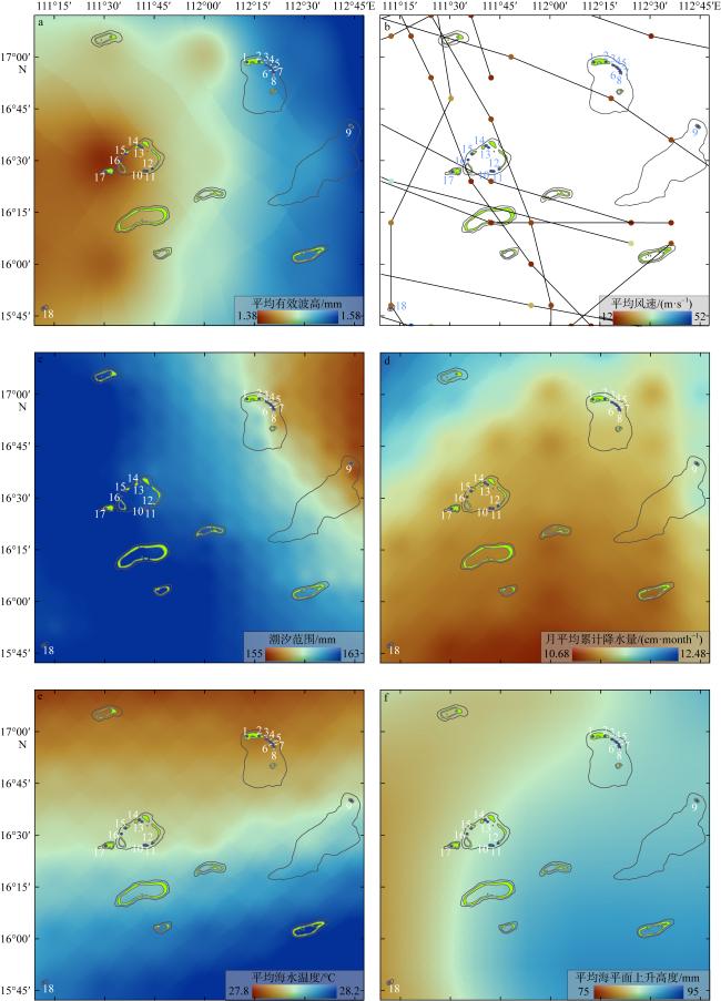
图4 2015—2023年西沙群岛区域海洋环境特征a. 平均有效波高; b. 历史过境台风路径; c. 潮汐范围; d. 月平均降水量; e. 平均海水温度; f. 平均海平面上升高度 Fig. 4 Regional marine environmental characteristics of the Xisha Islands from 2015 to 2023. (a) Mean significant wave height; (b) historical typhoon tracks; (c) tidal range; (d) monthly mean precipitation; (e) mean sea surface temperature; (f) mean sea level rise |
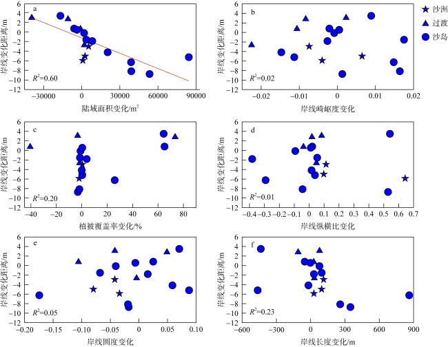
图5 六个海岸地貌参数陆域面积(a)、岸线崎岖度(b)、植被覆盖率(c)、岸线纵横比(d)、岸线圆度(e)和岸线长度(f)的变化与岸线变化距离之间的关联关系Fig. 5 Correlation between the shoreline change distance and the temporal variation of six coastal geomorphological parameters. (a) Subaerial area; (b) shoreline fractal dimension; (c) vegetation coverage rate; (d) shoreline axial ratio (major/minor axis); (e) shoreline circularity; and (f) shoreline length |
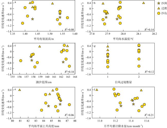
图6 六个海洋环境要素平均有效波高(a)、平均海水温度(b)、潮汐范围(c)、台风过境数量(d)、平均海平面上升高度(e)和月平均累计降水量(f)与岸线变化速率之间的关联性关系Fig. 6 Correlation between coastline change rates and six marine environmental characteristics: mean significant wave height (a), mean sea surface temperature (b), tidal range(c), numbers of historical typhoon passages (d), mean sea level rise anomaly (e), and monthly mean accumulated precipitation (f) |
| [1] |
陈燕珊, 戚洪帅, 杨清书, 等, 2022. 不同受损情况下珊瑚礁海岸动力地貌差异性分析[J]. 海洋学报, 44(3): 61-69.
|
| [2] |
贾美军, 姚宇, 何天城, 等, 2020. 大糙率礁面影响下珊瑚礁海岸附近规则波演化及爬高试验研究[J]. 海洋与湖沼, 51(6): 1344-1349.
|
| [3] |
江雷, 黄晖, 张浴阳, 等, 2016. 海水升温对壮实鹿角珊瑚幼虫存活和附着的影响[J]. 应用海洋学学报, 35(2): 217-222.
|
| [4] |
黎春红, 2005. 西沙群岛生态旅游开发设想[J]. 海洋开发与管理, 22(4): 62-67 (in Chinese).
|
| [5] |
李浩, 1991. 西沙群岛现代滨岸的风暴沉积[J]. 海洋地质与第四纪地质, 11(1): 83-91.
|
| [6] |
李嘉琪, 白爱娟, 蔡亲波, 2018. 西沙群岛和涠洲岛气候变化特征及其与近岸陆地的对比[J]. 热带地理, 38(1): 72-81.
|
| [7] |
李晓敏, 马毅, 张杰, 等, 2022. 基于高分遥感的西沙群岛珊瑚礁沙洲稳定性评估[J]. 海洋环境科学, 41(1): 48-58.
|
| [8] |
李秀保, 黄晖, 练健生, 等, 2007. 珊瑚及共生藻在白化过程中的适应机制研究进展[J]. 生态学报, 27(3): 1217-1225.
|
| [9] |
李言达, 易亮, 2021. 全球变暖和海洋酸化背景下珊瑚礁生态响应的研究进展[J]. 海洋地质与第四纪地质, 41(1): 33-41.
|
| [10] |
梁海萍, 梁海燕, 陈海南, 等, 2017. 1991—2013年发生在西沙永兴岛的台风风暴潮统计特征分析[J]. 应用海洋学学报, 36(2): 243-248.
|
| [11] |
刘晓红, 2020. 浅谈西沙群岛海域生态环境现状[J]. 化工管理, (20): 54-55 (in Chinese).
|
| [12] |
吕炳全, 王国忠, 全松青, 1987. 西沙群岛灰砂岛的沉积特征和发育规律[J]. 海洋地质与第四纪地质, (2): 59-69.
|
| [13] |
马小峰, 邹亚荣, 刘善伟, 2015. 基于分形维数理论的海岸线遥感分类与变迁研究[J]. 海洋开发与管理, 32(1): 30-33 (in Chinese).
|
| [14] |
秦志亮, 孙思军, 谭骏, 等, 2014. 西沙群岛海域海洋地质灾害现状与对策[J]. 海洋开发与管理, 31(9): 12-16 (in Chinese).
|
| [15] |
丘世钧, 1988. 我国珊瑚礁海岸的开发与管理[J]. 热带地貌, 9(1): 14-17.
|
| [16] |
邵超, 戚洪帅, 蔡锋, 等, 2016. 海滩-珊瑚礁系统风暴响应特征研究——以1409号台风“威马逊”对清澜港海岸影响为例[C]// 福建省海洋学会2016年学术年会. 厦门.
|
| [17] |
邵超, 林浩, 任海波, 等, 2022. 珊瑚礁海岸侵蚀的影响因素与响应特征分析[J]. 海洋科学前沿, 9(1): 30-38.
|
| [18] |
时小军, 刘元兵, 陈特固, 等, 2008. 全球气候变暖对西沙、南沙海域珊瑚生长的潜在威胁[J]. 热带地理, 28(4): 342-345, 368.
|
| [19] |
宋朝景, 赵焕庭, 1993. 珊瑚礁海岸和岛礁的建港问题[C]. 第七届全国海岸工程学术讨论会: 1032-1039 (in Chinese).
|
| [20] |
王明珠, 罗智勇, 韩飞, 2020a. 西沙群岛旅游地质资源调查研究[J]. 农村经济与科技, 31(17): 55-57, 64 (in Chinese).
|
| [21] |
王明珠, 韩飞, 符彩花, 2020b. 西沙永乐群岛岛礁海岸线变迁监测与分析[J]. 环境与发展, 32(1): 135-137.
|
| [22] |
许眸莹, 高抒, 葛晨东, 等, 2020. 南海九章环礁中牛轭礁和西门礁新生沙洲沉积特征与动态[J]. 热带海洋学报, 39(2): 44-53.
|
| [23] |
荀涛, 胡鹏, 梅弢, 等, 2009. 西沙群岛珊瑚砂运动特性试验研究[J]. 水道港口, 30(4): 277-281.
|
| [24] |
杨娟, 苏奋振, 石伟, 等, 2014. 南海珊瑚环礁开放程度模型构建研究[J]. 热带海洋学报, 33(3): 52-56.
|
| [25] |
杨绮薇, 黄增明, 林爱兰, 2001. 华南登陆台风频数的变化及其与ENSO事件的关系[J]. 气象, 27(3): 12-16.
|
| [26] |
姚宇, 张起铭, 蒋昌波, 2019. 礁面糙率变化下珊瑚礁海岸附近波浪传播变形试验[J]. 科学通报, 64(9): 977-985.
|
| [27] |
叶锦昭, 1996. 西沙群岛环境水文特征[J]. 中山大学学报(自然科学版), 35(S1): 15-21.
|
| [28] |
业治铮, 何起祥, 张明书, 等, 1985. 西沙群岛岛屿类型划分及其特征的研究[J]. 海洋地质与第四纪地质, (1): 1-13.
|
| [29] |
应明, 杨玉华, 陈葆德, 等, 2011. 近50年影响中国热带气旋的气候变化特征[J]. 中国科学: 地球科学, 41(9): 1352-1364 (in Chinese).
|
| [30] |
曾昭璇, 丘世钧, 1985. 西沙群岛环礁沙岛发育规律初探——以晋卿岛、琛航岛为例[J]. 海洋学报, 7(4): 472-483 (in Chinese).
|
| [31] |
张乔民, 余克服, 施祺, 2003. 华南珊瑚礁的海岸生物地貌过程[J]. 海洋地质动态, 19(11): 1-4, 30.
|
| [32] |
张志宏, 李悦铮, 2009. 海岛型旅游非优区的开发研究——以西沙群岛为例[C]// 第十四届全国区域旅游开发学术研讨会暨第二届海南国际旅游岛大论坛. 海口: 510-516 (in Chinese).
|
| [33] |
赵焕庭, 宋朝景, 余克服, 等, 1994. 西沙群岛永兴岛和石岛的自然与开发[J]. 海洋通报, 13(5): 44-56.
|
| [34] |
赵焕庭, 1996. 西沙群岛考察史[J]. 地理研究, 15(4): 55-65.
|
| [35] |
赵美霞, 姜大朋, 张乔民, 2017. 珊瑚岛的动态演变及其稳定性研究综述[J]. 热带地理, 37(5): 694-700.
|
| [36] |
|
| [37] |
|
| [38] |
|
| [39] |
|
| [40] |
|
| [41] |
|
| [42] |
|
| [43] |
|
| [44] |
|
| [45] |
|
| [46] |
|
| [47] |
|
| [48] |
|
| [49] |
|
| [50] |
|
| [51] |
|
| [52] |
|
| [53] |
|
| [54] |
|
| [55] |
|
| [56] |
|
| [57] |
|
| [58] |
|
| [59] |
|
| [60] |
|
| [61] |
|
| [62] |
|
| [63] |
|
| [64] |
|
| [65] |
|
| [66] |
|
| [67] |
|
| [68] |
|
| [69] |
|
| [70] |
|
| [71] |
|
| [72] |
|
| [73] |
|
| [74] |
|
| [75] |
|
| [76] |
|
| [77] |
|
| [78] |
|
| [79] |
|
| [80] |
|
| [81] |
|
| [82] |
|
| [83] |
|
| [84] |
|
| [85] |
|
| [86] |
|
| [87] |
|
| [88] |
|
| [89] |
|
| [90] |
|
| [91] |
|
| [92] |
|
| [93] |
|
| [94] |
|
| [95] |
|
| [96] |
|
| [97] |
|
| [98] |
|
| [99] |
|
| [100] |
|
| [101] |
|
| [102] |
|
| [103] |
|
/
| 〈 |
|
〉 |
