
钦州湾茅岭江河口红树林湿地动态变化过程
|
王日明(1971—), 男, 湖南省隆回县人, 教授, 博士, 研究方向为滨海景观生态修复。email: wangriming@bbgu.edu.cn |
Copy editor: 林强
收稿日期: 2025-02-11
修回日期: 2025-04-11
网络出版日期: 2025-04-16
基金资助
国家自然科学基金重点项目(41930537)
国家自然科学基金项目(42366009)
钦州市科学研究与技术开发计划项目(20223623)
Dynamic changes in mangrove wetland of the Maolingjiang Estuary, Qinzhou Gulf
Received date: 2025-02-11
Revised date: 2025-04-11
Online published: 2025-04-16
Supported by
National Natural Science Foundation Key Program of China(41930537)
National Natural Science Foundation of China(42366009)
Qinzhou Scientific Research and Technology Development Program(20223623)
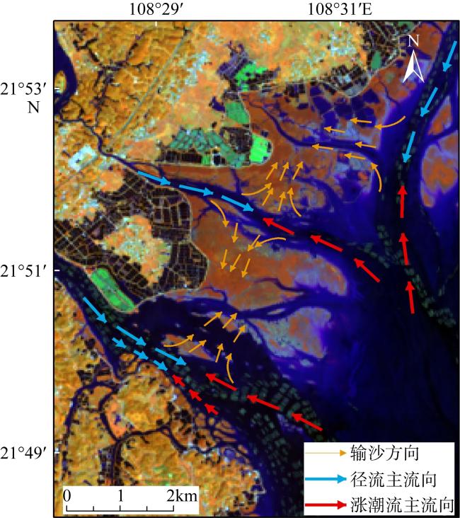
热带及亚热带潮间带红树林湿地拥有极为重要的滨海生态系统, 在抵御台风、护岸与固碳等方面具有重要价值。然而, 复杂的陆海相互作用与人类活动易引起红树林湿地发生较大规模损失。理解红树林湿地动态变化有利于全面掌握其变化与缘由, 为其受损修复提供关键支撑。为此, 本文基于Google Earth Engine平台获取的1992—2021年钦州湾茅岭江河口的23景陆地卫星TM(thematic mapper)与OLI(operational land imager)影像, 逐年提取红树林湿地面积, 以5年间隔诊断研究区6个时期4种土地覆盖类型面积, 以及170多条横断面上红树林林缘线和潮滩水边线, 揭示红树林湿地动态变化。结果表明: (1)截至2021年, 茅岭江河口1494.40hm2的潮滩分布有以桐花树为建群种的红树林707.76hm2, 红树林主要分布在大坜墩外滩和团和岛尾潮滩, 靠干流南侧梁屋外滩红树林分布最少; (2)1992—2021年, 茅岭江河口潮滩经历了“增加—减少—增加”的变化过程, 红树林湿地面积持续增加; (3)1992—2021年间养殖塘建设占用红树林是区域红树林面积阶段性减少的主要原因, 2002年以来相继启动的人工种植红树林项目导致红树林面积大幅度增加, 潮滩发育是红树林向海扩张的主要原因。
关键词: 红树林林缘线; 潮滩; 茅岭江河口; Google Earth Engine
王日明 , 苏金恒 , 戴志军 , 吴天亮 , 谢晓雯 , 黄春梅 , 李兴荣 , 张尚宇 . 钦州湾茅岭江河口红树林湿地动态变化过程[J]. 热带海洋学报, 2025 , 44(6) : 143 -154 . DOI: 10.11978/2025021
Mangrove wetlands, located in the intertidal zones of tropical and subtropical regions, are critically important coastal ecosystems, providing significant value in typhoon resistance, coastal seawall protection, and carbon sequestration. However, complex land-sea couplings have caused large-scale mangrove loss worldwide. Understanding the dynamic changes of mangrove wetlands is crucial for comprehensive grasping their losses and underlying causes, providing necessary support for their restoration. Based on the Google Earth Engine platform, this study extracted spatiotemporal dynamic information of mangrove wetlands at the Maolingjiang Estuary of Beibu Gulf from 1992 to 2021, and analyzed mangrove dynamics and associated influencing factors. The results showed that: (1) as of 2021, the tidal flats at the Maolingjiang Estuary contained 707.76 hm2 of mangroves, with Aegiceras corniculatum as the building species. Mangroves were mainly distributed in the Dalidun and Tuanhedao tidal flats, with the least distribution in the Liangwu tidal flat near the southern side of the main stream. (2) From 1992 to 2021, the tidal flats at the Maolingjiang Estuary experienced a process of "increase-decrease-increase", while mangrove area consistently expanded. (3) From 1992 to 2021, the construction of aquaculture ponds was the primary driver of phased regional mangrove loss, while large-scale mangrove afforestation projects initiated since 2002 led to a significant rebound in mangrove coverage, with tidal flat progradation serving as the key natural facilitator for seaward mangrove expansion.
表1 遥感影像信息Tab. 1 Remote sensing image information |
| 序号 | 成像日期 | 时刻 | 卫星 | 分辨率/m | 总体精度OA | Kappa系数 |
|---|---|---|---|---|---|---|
| 1 | 1992-10-23 | 10:32 | Landsat 5 TM | 30 | 0.95 | 0.94 |
| 2 | 1994-11-14 | 10:25 | Landsat 5 TM | 30 | 0.96 | 0.95 |
| 3 | 1996-12-21 | 10:33 | Landsat 5 TM | 30 | 0.95 | 0.94 |
| 4 | 1997-08-18 | 10:42 | Landsat 5 TM | 30 | 0.96 | 0.95 |
| 5 | 1998-08-21 | 10:49 | Landsat 5 TM | 30 | 0.92 | 0.91 |
| 6 | 1999-09-25 | 10:47 | Landsat 5 TM | 30 | 0.94 | 0.92 |
| 7 | 2000-09-11 | 10:49 | Landsat 5 TM | 30 | 0.96 | 0.95 |
| 8 | 2002-11-04 | 10:43 | Landsat 5 TM | 30 | 0.95 | 0.94 |
| 9 | 2003-04-13 | 10:45 | Landsat 5 TM | 30 | 0.93 | 0.92 |
| 10 | 2004-06-02 | 10:52 | Landsat 5 TM | 30 | 0.95 | 0.94 |
| 11 | 2006-12-17 | 11:05 | Landsat 5 TM | 30 | 0.97 | 0.96 |
| 12 | 2007-07-29 | 11:04 | Landsat 5 TM | 30 | 0.98 | 0.98 |
| 13 | 2008-05-12 | 10:59 | Landsat 5 TM | 30 | 0.97 | 0.96 |
| 14 | 2009-05-31 | 10:59 | Landsat 5 TM | 30 | 0.97 | 0.97 |
| 15 | 2011-06-22 | 11:00 | Landsat 5 TM | 30 | 0.96 | 0.95 |
| 16 | 2013-11-02 | 11:12 | Landsat 8 OLI | 30 | 0.93 | 0.92 |
| 17 | 2014-06-14 | 11:10 | Landsat 8 OLI | 30 | 0.93 | 0.91 |
| 18 | 2015-04-14 | 11:10 | Landsat 8 OLI | 30 | 0.96 | 0.95 |
| 19 | 2017-05-05 | 11:10 | Landsat 8 OLI | 30 | 0.95 | 0.94 |
| 20 | 2018-07-11 | 11:10 | Landsat 8 OLI | 30 | 0.98 | 0.98 |
| 21 | 2019-08-15 | 11:11 | Landsat 8 OLI | 30 | 0.98 | 0.98 |
| 22 | 2020-09-02 | 11:11 | Landsat 8 OLI | 30 | 0.98 | 0.98 |
| 23 | 2021-04-30 | 11:10 | Landsat 8 OLI | 30 | 0.96 | 0.96 |
表2 遥感影像数据及潮位信息Tab. 2 Remote sensing image data and tide level information |
| 序号 | 成像时间 | 时刻 | 卫星 | 分辨率/m | 潮位/cm |
|---|---|---|---|---|---|
| 1 | 1992-10-23 | 10:32 | Landsat 5 TM | 30 | 288 |
| 2 | 1997-08-02 | 10:42 | Landsat 5 TM | 30 | 298 |
| 3 | 2002-11-04 | 10:43 | Landsat 5 TM | 30 | 297 |
| 4 | 2007-07-29 | 11:04 | Landsat 5 TM | 30 | 279 |
| 5 | 2014-06-14 | 11:10 | Landsat 8 OLI | 30 | 297 |
| 6 | 2021-04-30 | 11:10 | Landsat 8 OLI | 30 | 280 |
表3 潮滩高程断面监测Tab. 3 Monitoring of tidal flat elevation section |
| 断面序号 | 平均坡度 | L/m |
|---|---|---|
| D1 | 0.22% | 85.90 |
| D2 | 0.69% | 27.35 |
| D3 | 0.39% | 48.25 |
| D4 | 0.24% | 79.22 |
注: L为潮位279cm与298 cm之间的最大滩面宽度。 |
图3 茅岭江河口红树林向海扩张趋势a. 红树林林缘线动态变化; b. 区域红树林林缘线变化速率; c. 红树林林缘线年际变化 Fig. 3 Seaward expansion trend of mangroves at Maolingjiang Estuary. (a) Dynamic changes of mangrove fringe line; (b) change rate of mangrove fringe line in regional mangrove; (c) interannual variation of mangrove fringe line |
图5 茅岭江河口潮滩水边线动态变化a. 1992—2021年水边线变化速率; b. 1992—2021年水边线动态; c. 1992—2007年潮滩水边线迁移距离; d. 2007—2014年潮滩水边线迁移距离; e. 2014—2021年潮滩水边线迁移距离 Fig. 5 Dynamic changes in tidal flat water boundary line at Maolingjiang Estuary. (a) Change rate of the water boundary line from 1992 to 2021; (b) dynamic changes in water boundary line from 1992 to 2021; (c) migration distance of tidal flat water boundary line from 1992 to 2007; (d) migration distance of tidal flat water boundary line from 2007 to 2014; (e) migration distance of tidal flat water boundary line from 2014 to 2021 |
表4 各地类侵占红树林面积Tab. 4 Area of mangrove encroachment by different land types |
| 年份 | 裸滩面积/hm2 | 水域(养殖塘)面积/hm2 | 其他面积/hm2 |
|---|---|---|---|
| 1992—1997 | 1.25 | 0.08(0.00) | 0.17 |
| 1997—2002 | 6.07 | 7.49(4.74) | 1.17 |
| 2002—2007 | 1.25 | 0.92(0.67) | 0.67 |
| 2007—2013 | 2.00 | 3.83(0.67) | 0.33 |
| 2013—2018 | 4.58 | 6.32(4.24) | 5.37 |
| 2018—2021 | 27.58 | 14.89(11.23) | 3.25 |
| 总和 | 42.72 | 33.53(21.55) | 10.94 |
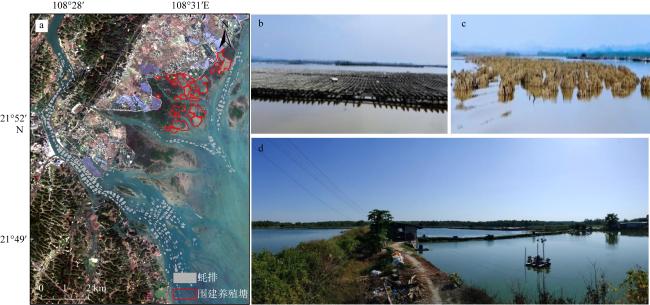
图7 研究区内人类活动情况a. 茅岭江河口蚝排与养殖塘分布(基于2023年1月20日的Sentinel-2A影像); b. 茅岭江河口蚝排; c. 茅岭江河口蚝柱; d. 围建养殖塘 Fig. 7 Human activities in the study area. (a) Distribution of oyster rafts and aquaculture ponds in the Maolingjiang Estuary; (b) oyster rafts in the Maolingjiang Estuary; (c) oyster culture poles in the Maolingjiang Estuary; (d) constructed aquaculture ponds |
| [1] |
陈高, 钟才荣, 李明玉, 等, 2022. 1990年—2020年广西北仑河口红树林扰动研究[J]. 遥感学报, 26(6): 1112-1120.
|
| [2] |
陈顺洋, 安文硕, 陈彬, 等, 2021. 红树林生态修复固碳效果的主要影响因素分析[J]. 应用海洋学学报, 40(1): 34-42.
|
| [3] |
陈一宁, 陈鹭真, 2023. 滨海蓝碳生态系统的碳库间相互作用研究进展及展望[J]. 海洋学研究, 41(1): 3-13.
|
| [4] |
陈主器, 2021. 广西钦州大蚝苗种产业发展的问题与对策[J]. 养殖与饲料, 20(11): 166-167 (in Chinese).
|
| [5] |
戴志军, 周晓妍, 王杰, 等, 2021. 红树林潮滩沉积动力研究进展与展望[J]. 热带海洋学报, 40(3): 69-75.
|
| [6] |
邓建明, 姚航, 付波霖, 等, 2025. 基于GEE和时序主被动影像的广西北部湾红树林时空动态监测研究[J]. 自然资源遥感, 37(2): 235-245.
|
| [7] |
范航清, 莫竹承, 2018. 广西红树林恢复历史、成效及经验教训[J]. 广西科学, 25(4): 363-371+387.
|
| [8] |
郭晋宇, 耿晓晓, 尹雷, 等, 2023. 海南儋州湾贝克喜盐草资源分布特征及影响因素分析[J]. 海洋湖沼通报, 45(2): 123-132.
|
| [9] |
黄李丛, 苏宏河, 唐丰利, 2013. 钦州市引种无瓣海桑现状及发展对策分析[J]. 广东科技, 22 (14): 188-189 (in Chinese).
|
| [10] |
贾明明, 王宗明, 毛德华, 等, 2021. 面向可持续发展目标的中国红树林近50年变化分析[J]. 科学通报, 66(30): 3886-3901.
|
| [11] |
李春干, 代华兵, 2015. 1960—2010年广西红树林空间分布演变机制[J]. 生态学报, 35(18): 5992-6006.
|
| [12] |
李瑞利, 杨芳, 王辉, 等, 2022. 红树林保护与修复标准发展现状及对策[J]. 北京大学学报(自然科学版), 58(5): 916-928.
|
| [13] |
梁喜幸, 王日明, 戴志军, 等, 2023. 茅尾海钦江河口光滩时空变化过程研究[J]. 海洋地质与第四纪地质, 43(3): 107-118.
|
| [14] |
马进荣, 程梦妍, 廖文凯, 等, 2019. 广西茅岭江入海典型污染物通量估算方法[J]. 广西科学, 26(3): 335-340.
|
| [15] |
潘嵩, 王慧, 李欢, 等, 2020. 基于SLAMM模型的海平面上升对广西沿海红树林影响研究[J]. 海洋通报, 39(3): 325-334.
|
| [16] |
申键, 简焯锴, 欧阳雪敏, 等, 2024. 结合潮位校正的雷州半岛红树林湿地动态变迁遥感监测[J]. 热带海洋学报, 43(1): 137-153.
|
| [17] |
汪振松, 冯志勇, 陈鹏, 等, 2022. 近30年深圳湾红树林群落演变过程及其对人类活动的响应[J]. 中国农村水利水电, (12): 24-30.
|
| [18] |
王日明, 戴志军, 黄鹄, 等, 2021. 南流江河口桐花树生物动力地貌过程研究[J]. 海洋学报, 43(9): 102-114.
|
| [19] |
王日明, 黄鹄, 2020. 南流江口洲滩景观过程研究[J]. 海洋科学, 44(12): 84-92.
|
| [20] |
王日明, 梁喜幸, 周晓妍, 等, 2022. 钦江河口潮滩红树林群落空间分布[J]. 遥感学报, 26(6): 1143-1154.
|
| [21] |
吴庭天, 丁山, 陈宗铸, 等, 2020. 基于LUCC和景观格局变化的海南东寨港红树林湿地动态研究[J]. 林业科学研究, 33(5): 154-162.
|
| [22] |
杨钰文, 卢远, 黄萍, 2020. 基于遥感的北部湾茅尾海岸滩时空变化研究[J]. 海洋技术学报, 39(4): 1-8.
|
| [23] |
于凌云, 林绅辉, 焦学尧, 等, 2019. 粤港澳大湾区红树林湿地面临的生态问题与保护对策[J]. 北京大学学报(自然科学版), 55(4): 782-790.
|
| [24] |
张文良, 郭俊丽, 刘卓成, 等, 2025. 钦州湾与马尼拉湾岸线时空变化与围填海分析[J]. 热带地理, 45(3): 489-503.
|
| [25] |
|
| [26] |
|
| [27] |
|
| [28] |
|
| [29] |
|
| [30] |
|
| [31] |
|
| [32] |
|
| [33] |
|
| [34] |
|
| [35] |
|
| [36] |
|
| [37] |
|
| [38] |
|
| [39] |
|
| [40] |
|
| [41] |
|
/
| 〈 |
|
〉 |


