
人类活动影响下的钦州湾近期滩槽冲淤演变特征
|
杨留柱(1983—), 男, 河南省开封市人, 高级工程师, 博士研究生, 主要从事河口海岸演变方面研究。 |
Copy editor: 林强
收稿日期: 2019-01-23
要求修回日期: 2019-02-23
网络出版日期: 2019-11-26
基金资助
国家重点研发计划项目(2018YFC0407804)
国家自然科学基金项目(51779280)
广西水利厅科技项目(201602)
版权
Characteristics of recent evolution in Qinzhou Bay influenced by human activities
Copy editor: LIN Qiang
Received date: 2019-01-23
Request revised date: 2019-02-23
Online published: 2019-11-26
Supported by
National Key Research and Development Project(2018YFC0407804)
National Natural Science Foundation of China(51779280)
Scientific and Technological Projects of Guangxi Water Resources Department(201602)
Copyright
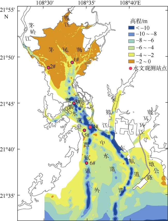
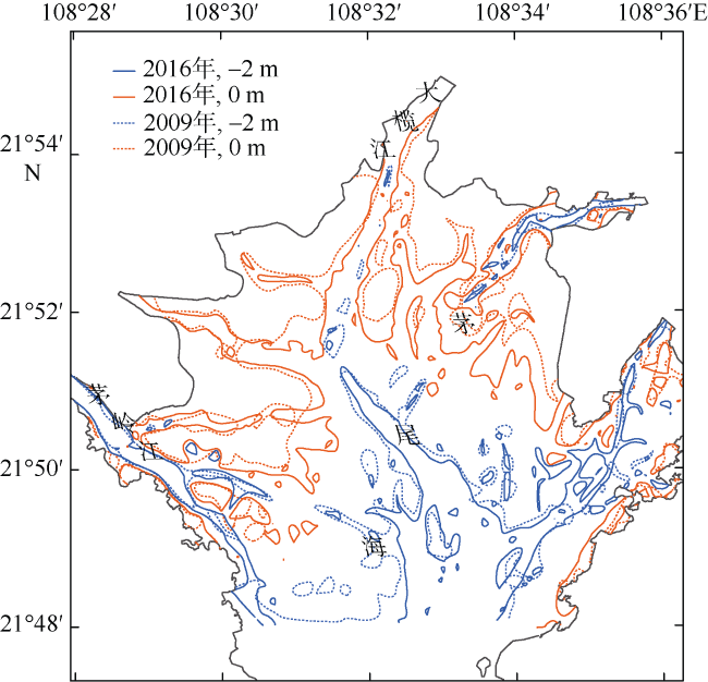
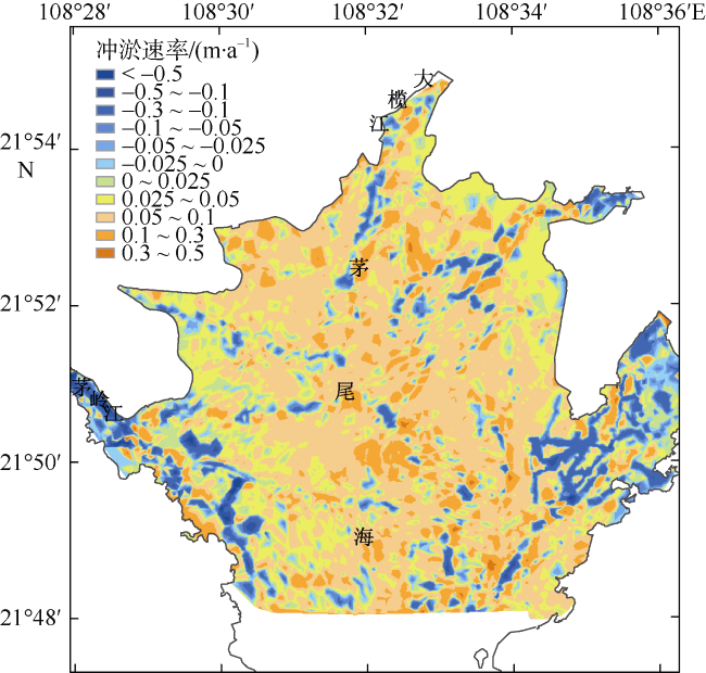
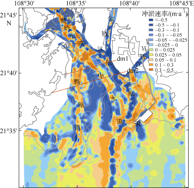
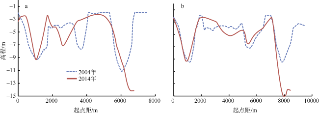
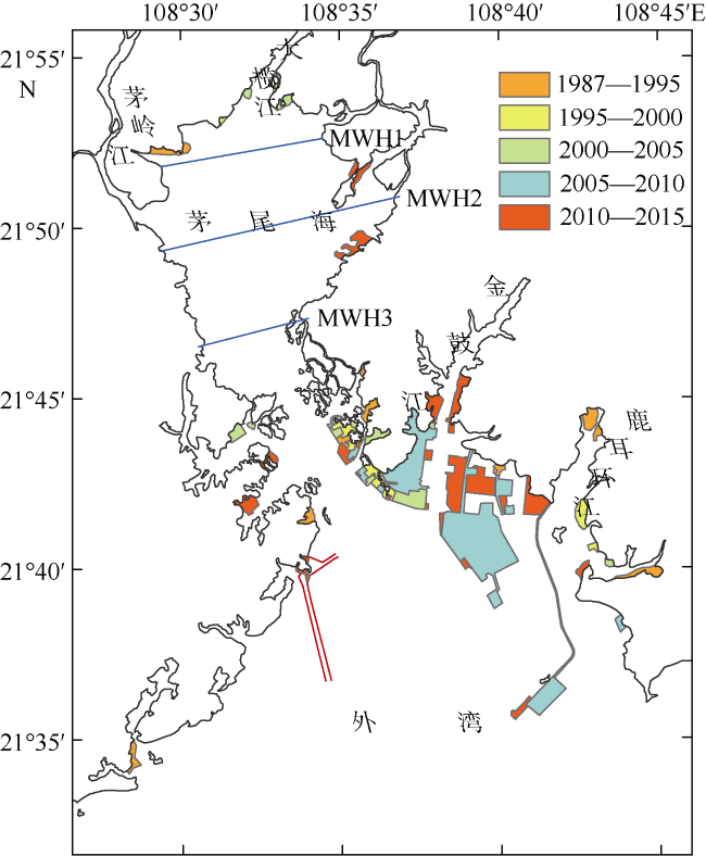
根据1980年代以来水下地形数据和遥感影像资料, 综合运用遥感与地理信息系统(geographic information system, GIS)、数值模拟等技术手段, 分析了钦州湾近期高强度人类活动影响下的滩槽平面变化和冲淤演变特征, 从动力地貌角度对演变原因进行了探讨。研究表明, 内湾茅尾海近期整体淤积, 2m等深线以浅的高滩淤积强度显著大于其他水域, 局部槽道由于人工采砂和潮流动力增强而出现冲刷。外湾整体以淤积为主, 但强度小于内湾, 滩和槽的冲淤特征差异显著, 西航道、中水道和边滩淤积, 中滩和东航道冲刷。高强度人类活动前后钦州湾涨、落潮量分别减少约4.59%和4.04%, 潮流动力减弱, 导致茅尾海不断淤积; 外湾中部岸线向海大幅推进, 使得中滩涨落潮流流势集中, 潮流速普遍增加0.1~0.2m·s -1, 是中滩大范围冲刷的主要原因; 东航道浚深后, 中槽涨落潮流向东航道产生归槽, 导致潮流动力减弱, 中槽萎缩。水平Kelvin数变化表明, 人类活动对外湾东航道和中水道的影响最大, 东航道稳定性增强, 中水道持续萎缩; 西航道受到影响较小, 稳定性基本保持不变。
杨留柱 , 杨莉玲 , 潘洪州 , 刘超群 , 喻丰华 . 人类活动影响下的钦州湾近期滩槽冲淤演变特征[J]. 热带海洋学报, 2019 , 38(6) : 41 -50 . DOI: 10.11978/2019013
Based on the underwater topographical data and remote sensing data from the 1980s, we analyze the characteristics of shoal-trough pattern change and erosion-siltation evolution in Qinzhou Bay under the influence of recent high intensity human activities. We also discuss the reasons from the aspect of dynamic geomorphology combining the methods of remote sensing, GIS, and numerical simulation. The results indicate that the Maowei Sea showed overall deposition, the siltation intensity of the shallow water area above the 2m isobath was significantly greater than that in the other areas, and the channel was characterized by erosion due to artificial sand mining and enhancement of tidal current. The outer bay was dominated by deposition, but its deposition rate was less than that of the inner bay. The scouring and silting characteristics of the shoal and trough were significantly different. The west channel, middle channel, and the side foreland were dominated by deposition, while Middle Shoal, East Channel were characterized by scour. Due to high intensity human activities, the flood and ebb tidal capacity of the Maowei Sea reduced 4.6% and 4%, respectively, which caused continuous deposit. The coastline in the middle of the outer bay has been pushed toward the sea significantly, which made the tidal current concentrated and increased velocity by 0.1~0.2 m·s -1, leading to the erosion of the Middle Shoal. The deepening of the East Channel made flow in the Middle Channel move to the East Channel, which made the Middle Channel shrink. The changes of the horizontal Kelvin number indicate that human activities have greater impact on the East and Middle channels of the outer bay. The stability of the East Channel is enhanced and the Middle Channel continues to shrink, while the stability of the West Channel remains basically unchanged.
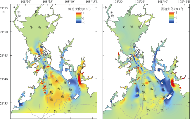
图8 2004—2014年间钦州湾冲淤速率分布 dm1、dm2为选取的横断面Fig. 8 The speed of scour and silting of the Outer Bay during 2004-2014 |
表1 钦州湾冲淤特征参数统计表Tab. 1 Statistics of erosion and deposition characteristics in Qinzhou Bay |
| 高程/m | 2009—2016茅尾海冲淤特征 | 高程/m | 2004—2014外湾冲淤特征 | ||||
|---|---|---|---|---|---|---|---|
| 冲淤量/(×104m3) | 冲淤厚度/m | 冲淤速率/(m·a-1) | 冲淤量/(×104m3) | 冲淤厚度/m | 冲淤速率/(m·a-1) | ||
| >0 | 1061.14 | 0.44 | 0.06 | -4~0 | 2741.52 | 0.32 | 0.03 |
| -2~0 | 1514.04 | 0.27 | 0.04 | -7~-4 | 80.63 | 0.02 | 0.00 |
| -4~-2 | 228.27 | 0.16 | 0.02 | -7~-12 | -748.99 | -0.30 | -0.03 |
| -4~2 | 2803.44 | 0.29 | 0.04 | -12~0 | 2073.16 | 0.13 | 0.01 |
表2 2004—2014年间高强度人类活动下茅尾海涨落潮量变化统计Tab. 2 Change of tidal capacity caused by high intensity human activities during 2004—2014 |
| 观测断面 | 涨潮量/m3 | 变化率/% | 落潮量/m3 | 变化率/% | ||
|---|---|---|---|---|---|---|
| 开发前 | 变化值 | 开发前 | 变化值 | |||
| MWH1 | 123509 | -11149.2 | -9.03% | 99029.8 | -3548.03 | -3.58% |
| MWH2 | 553833 | -15502.6 | -2.80% | 307062.7 | -17837.2 | -5.81% |
| MWH3 | 1002491 | -19487.41 | -1.94% | 664348.3 | -18084.2 | -2.72% |
表3 开发前后主要深槽水平Keh变化情况Tab. 3 Change of horizontal Kelvin number before and after high intensity human activities |
| U/(m·s-1) | B/m | H/m | Keh | |||||
|---|---|---|---|---|---|---|---|---|
| 工程前 | 工程后 | 工程前 | 工程后 | 工程前 | 工程后 | 工程前 | 工程后 | |
| 西航道(dm1) | 1.20 | 1.15 | 1294.99 | 1252.38 | 9.27 | 9.28 | 0.20 | 0.19 |
| 西航道(dm2) | 1.09 | 0.98 | 1063.20 | 1086.81 | 9.43 | 9.18 | 0.15 | 0.14 |
| 中水道(dm1) | 1.27 | 1.02 | 636.87 | 1477.59 | 7.45 | 6.9 | 0.13 | 0.26 |
| 中水道(dm2) | 1.18 | 1.16 | 1018.49 | 3235.52 | 7.11 | 6.58 | 0.20 | 0.68 |
| 东航道(dm1) | 1.22 | 1.07 | 1197.43 | 894.67 | 11.14 | 13.45 | 0.16 | 0.08 |
| 东航道(dm2) | 1.06 | 0.97 | 1279.07 | 627.88 | 9.52 | 15.15 | 0.17 | 0.05 |
| 1 |
董德信, 李谊纯, 陈宪云 , 等, 2014. 大规模填海工程对钦州湾水动力环境的影响[J]. 广西科学, 21(4):357-364, 369.
|
| 2 |
董德信, 李谊纯, 陈宪云 , 等, 2015. 海洋工程对钦州湾岸线地形及泥沙冲淤的影响[J]. 广西科学, 22(3):266-273.
|
| 3 |
高劲松, 陈波, 陆海生 , 等, 2014. 钦州湾潮流场及污染物输运特征的数值研究[J]. 广西科学, 21(4):345-350.
|
| 4 |
黎广钊, 梁文, 刘敬合 , 2001. 钦州湾水下动力地貌特征[J]. 地理学与国土研究, 17(4):70-75.
|
| 5 |
黎广钊, 梁文, 刘敬合 , 2002. 从沉积物中重矿物动力分区论钦州湾泥沙来源及运移趋势[J]. 海洋通报, 21(5):61-68.
|
| 6 |
李树华, 方龙驹 , 1989. 钦州湾潮汐和潮流的变化特征[J]. 海岸工程, 8(3):39-45.
|
| 7 |
王丹 , 2016. 广西茅尾海水域砂船安全评价研究[D]. 大连: 大连海事大学: 11-14.
|
| 8 |
王玉海, 王崇浩, 刘大滨 , 等, 2010. 钦州湾水道稳定性的初步研究[J]. 水运工程, ( 8):76-80.
|
| 9 |
王玉海 , 2013. 钦州湾滩槽地貌体系演化数值模拟研究[J]. 水运工程,( 1): 45- 50, 75.
|
| 10 |
阎新兴, 刘国亭 , 2006. 钦州湾近海区沉积特征及航道淤积研究[J]. 水道港口, 27(2):79-83.
|
| 11 |
张伯虎, 陈沈良, 谷国传 , 等, 2010. 钦州湾潮流深槽的成因与稳定性探讨[J]. 海岸工程, 29(3):43-50.
|
| 12 |
张伯虎, 陈沈良, 刘焱雄 , 等, 2011. 广西钦州湾海域表层沉积物分异特征与规律[J]. 热带海洋学报, 30(4):66-70.
|
| 13 |
郑暖方 , 1988. 钦州湾水动力条件及悬沙分布变化特征[J]. 海岸工程, 7(1):48-54.
|
| 14 |
|
| 15 |
|
| 16 |
|
| 17 |
|
| 18 |
|
| 19 |
|
| 20 |
|
| 21 |
|
/
| 〈 |
|
〉 |


