
热带海洋学报 ›› 2021, Vol. 40 ›› Issue (5): 111-122.doi: 10.11978/2020131CSTR: 32234.14.2020131
南海北部陆缘OBS2018-H2测线地壳结构初步结果*
苏晓康1,3( ), 赵明辉1,2,3(), 李子正1,3, 袁野1,3, 王星月1,3, 程锦辉1,3, 张佳政1,2
- 1.中国科学院边缘海与大洋地质重点实验室(南海海洋研究所), 南海生态环境工程创新研究院, 广东 广州 510301
2.南方海洋科学与工程广东省实验室(广州), 广东 广州 511458
3.中国科学院大学, 北京 100049
-
收稿日期:2020-11-10修回日期:2021-01-04出版日期:2021-09-10发布日期:2021-01-08 -
通讯作者:赵明辉 -
作者简介:苏晓康(1995—), 男, 河南省开封市人, 硕士研究生, 研究方向为海洋地球物理。email:suxiaokang@scsio.ac.cn -
基金资助:国家自然科学基金(41730532);国家自然科学基金(91958212);国家自然科学基金(42002222);国家自然科学基金(91858212);南方海洋科学与工程广东省实验室(广州)人才团队引进重大专项(GML2019ZD0204)(GML2019ZD0204);广东省自然科学基金团队项目(2017A030312002)
Preliminary results of the crustal structure along OBS2018-H2 in the northern continental margin of the South China Sea*
SU Xiaokang1,3(), ZHAO Minghui1,2,3(), LI Zizheng1,3, YUAN Ye1,3, WANG Xingyue1,3, CHENG Jinhui1,3, ZHANG Jiazheng1,2
- 1. CAS Key Laboratory of Ocean and Marginal Sea Geology (South China Sea Institute of Oceanology), Innovation Academy of South China Sea Ecology and Environmental Engineering, Chinese Academy of Sciences, Guangzhou 510301, China
2. Southern Marine Science and Engineering Guangdong Laboratory (Guangzhou), Guangzhou 511458, China
3. University of Chinese Academy of Sciences, Beijing 100049, China
-
Received:2020-11-10Revised:2021-01-04Online:2021-09-10Published:2021-01-08 -
Contact:ZHAO Minghui -
Supported by:Natural Science Foundation of China(41730532);Natural Science Foundation of China(91958212);Natural Science Foundation of China(42002222);Natural Science Foundation of China(91858212);Key Special Project for Introduced Talents Team of Southern Marine Science and Engineering Guangdong Laboratory(Guangzhou)(GML2019ZD0204);Guangdong Natural Science Foundation research team project(2017A030312002)
摘要:
南海北部陆缘洋陆转换带实施的OBS2018-H2测线的地壳速度结构, 将为探讨南海张裂-破裂机制提供重要证据。文章介绍了OBS2018-H2测线前期数据处理流程, 包括多道反射地震数据处理、海底地震仪OBS (Ocean Bottom Seismometer)数据格式转换、炮点和OBS位置校正, 以及OBS震相的初步识别, 并对地壳结构进行了初步分析。结果表明: 炮点和OBS位置校正效果良好; 多道反射地震数据为建立初始速度模型提供了良好约束; OBS综合地震剖面识别了多组清晰的P波震相, 包括Pw、Pg、PmP和Pn震相。根据测线西侧OBS36、OBS37两台站的震相分布特征初步估算台站下方地壳厚度约为6~7km, 与根据多道地震剖面LW3的双程走时估算的厚度6~9km大致相符。
中图分类号:
- P712.83
引用本文
苏晓康, 赵明辉, 李子正, 袁野, 王星月, 程锦辉, 张佳政. 南海北部陆缘OBS2018-H2测线地壳结构初步结果*[J]. 热带海洋学报, 2021, 40(5): 111-122.
SU Xiaokang, ZHAO Minghui, LI Zizheng, YUAN Ye, WANG Xingyue, CHENG Jinhui, ZHANG Jiazheng. Preliminary results of the crustal structure along OBS2018-H2 in the northern continental margin of the South China Sea*[J]. Journal of Tropical Oceanography, 2021, 40(5): 111-122.
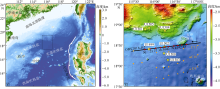
图1
南海北部陆缘OBS2018-H2测线位置与水深地形图 图a中的黑色方框表示图b的位置; 图b中黑色粗实线为OBS2018-H2测线; 黑色箭头代表放炮方向; 黄色五角星代表IODP钻探站位; 红色实心圆代表OBS台站; 橙色实心矩形、圆形和三角形分别代表磁异常C11、C10、C9 [据Briais等(1993)]; 水深数据来自GEBECO_2019, http://www.geobco.net。审图号: GS(2016)1609"

图1
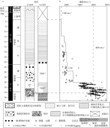
图2
IODP站位U1499和U1502的钻探结果 a. 站位U1499和U1502的岩性柱状图[据Larsen等(2018a)修改]; b. 站位U1502的速度间隔模型[据Larsen等(2018b)修改], 空心小正方形和小三角形代表纵波测量仪PWC (P-wave caliper)数据, 空心小圆代表测井数据"
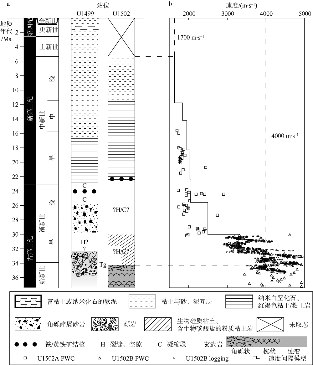
图2
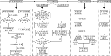
图3
OBS数据处理流程图"
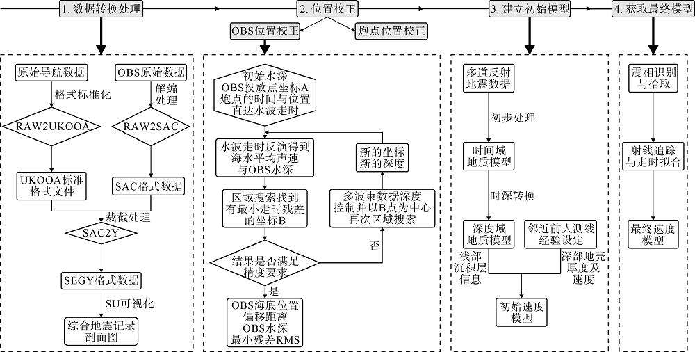
图3

图4
炮点和OBS位置校正前后对比图 炮点对应的数字为其序号, 每隔50炮突出显示一次; OBS对应的为其代号; 炮点校正后的OBS2018-H2测线: y=0.1243x+4.0068"
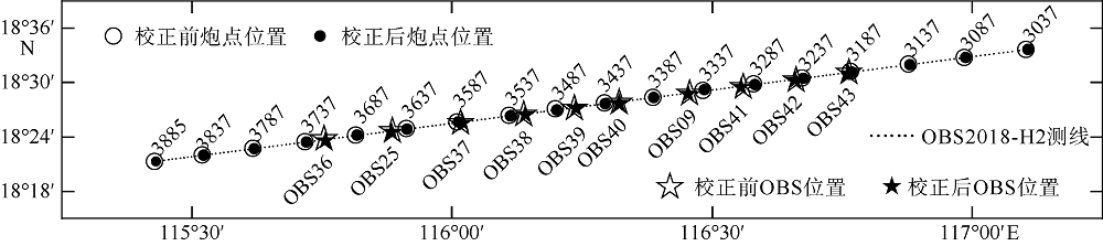
图4
表1
OBS2018-H2测线10台OBS位置校正结果表"
| OBS 编号 | 投放位置 | 校正后位置 | 校正后 水深/m | 海水 声速/(m·s-1) | 漂移 距离/m | RMS /ms | |||
|---|---|---|---|---|---|---|---|---|---|
| 东经/(°) | 北纬/(°) | 东经/(°) | 北纬/(°) | ||||||
| 09 | 116.45648 | 18.48332 | 116.45343 | 18.48297 | 3800.2 | 1501.4 | 324.8 | 3.4 | |
| 25 | 115.88451 | 18.41252 | 115.88423 | 18.41135 | 3768.7 | 1501.3 | 131.9 | 4.8 | |
| 36 | 115.75399 | 18.39623 | 115.75665 | 18.39637 | 3766.2 | 1503.1 | 281.8 | 3.5 | |
| 37 | 116.01618 | 18.42904 | 116.01979 | 18.42997 | 3762.6 | 1500.1 | 394.2 | 4.4 | |
| 38 | 116.13817 | 18.44404 | 116.14042 | 18.44650 | 3763.0 | 1501.1 | 361.5 | 3.3 | |
| 39 | 116.23545 | 18.45643 | 116.23679 | 18.45858 | 3772.5 | 1500.2 | 277.6 | 4.7 | |
| 40 | 116.32148 | 18.46648 | 116.32100 | 18.46810 | 3781.6 | 1500.2 | 185.6 | 3.8 | |
| 41 | 116.55881 | 18.49536 | 116.55592 | 18.49517 | 3813.9 | 1498.1 | 305.6 | 4.7 | |
| 42 | 116.66120 | 18.50772 | 116.65918 | 18.50749 | 3837.5 | 1500.3 | 214.6 | 2.1 | |
| 43 | 116.76341 | 18.52016 | 116.76122 | 18.51933 | 3871.1 | 1499.1 | 248.5 | 3.7 | |
表1
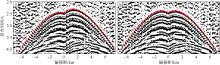
图5
OBS37台站直达水波震相Pw校正前(a)和校正后(b)对比 折合速度为6.0km·s-1, 折合时间=绝对走时-偏移距/6"
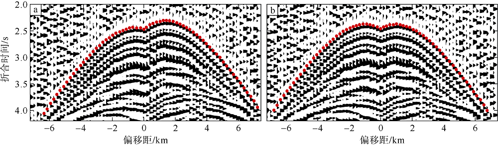
图5
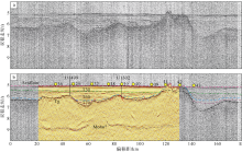
图6
多道反射地震剖面及其层位解释 a. 随船采集的原始多道反射地震剖面; b. 多道反射地震剖面层位解释, 黄色实心圆代表OBS台站, 黑色竖直实线代表IODP钻探站位U1499和U1502, 粉红色、黑色和褐色虚线分别代表海底(Seafloor)、基底(Tg)、莫霍面(Moho), 绿色、蓝色、紫色虚线分别代表不整合T30、T60、T70, 红色短线段代表断层"
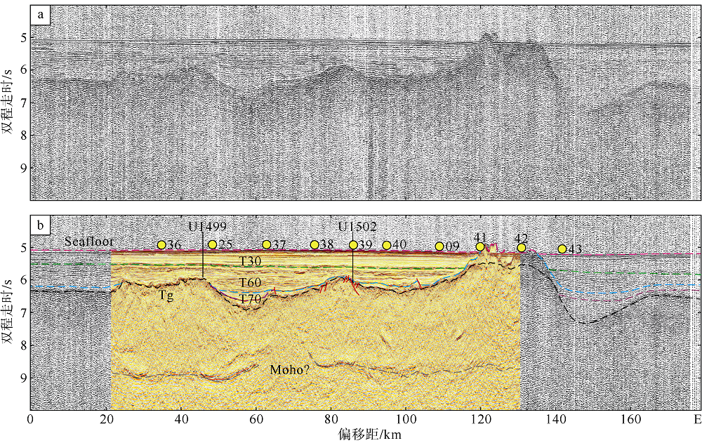
图6

图7
时深转换计算各参数对应图"
图7

图8
OBS2018-H2测线的初始速度模型 黄色实心圆代表OBS台站; 沉积层内的曲线代表图6中的沉积界面T30、T60、T70; 虚线代表6.4km·s-1速度等值面"
图8
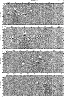
图9
OBS36 (a)、OBS37 (b)、OBS09 (c)和OBS42 (d)的垂直分量综合地震记录剖面 折合速度为6.0km·s-1, 折合时间=绝对走时-偏移距/6; Pw代表直达水波震相, Pg代表地壳内部折射震相, PmP代表莫霍面反射震相, Pn代表上地幔顶部折射震相"
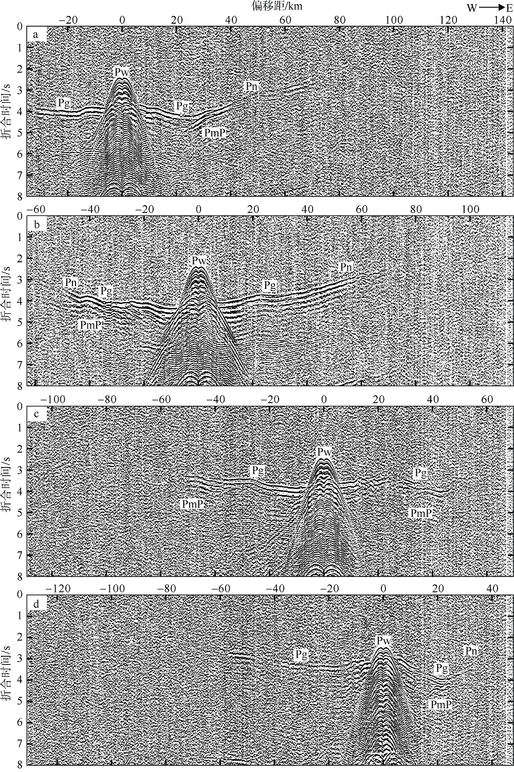
图9
| [1] | 敖威, 赵明辉, 丘学林, 等, 2010. 西南印度洋中脊三维地震探测中炮点与海底地震仪的位置校正[J]. 地球物理学报, 53(12):2982-2991. |
| AO WEI, ZHAO MINGHUI, QIU XUELIN, et al, 2010. The correction of shot and OBS position in the 3D seismic experiment of the SW India Ocean Ridge[J]. Chinese Journal of Geophysics, 53(12):2982-2991 (in Chinese with English abstract). | |
| [2] | 郭玲莉, 李三忠, 赵淑娟, 等, 2017. 洋-陆转换带类型与成因机制[J]. 地学前缘, 24(4):320-328. |
| GUO LINGLI, LI SANZHONG, ZHAO SHUJUAN, et al, 2017. Formation mechanism and types of ocean-continent transition zones[J]. Earth Science Frontiers, 24(4):320-328 (in Chinese with English abstract). | |
| [3] | 郝天珧, 游庆瑜, 2011. 国产海底地震仪研制现状及其在海底结构探测中的应用[J]. 地球物理学报, 54(12):3352-3361. |
| HAO TIANYAO, YOU QINGYU, 2011. Progress of homemade OBS and its application on ocean bottom structure survey[J]. Chinese Journal of Geophysics, 54(12):3352-3361 (in Chinese with English abstract). | |
| [4] | 李春峰, 汪品先, FRANKE D, 等, 2009. 南海张裂过程及其对晚中生代以来东南亚构造的启示[J]. 地球科学进展, 24(12):1339-1351. |
| LI CHUNFENG, WANG PINXIAN, FRANKE D, et al, 2009. Opening of the South China Sea and its implications for Southeast Asian tectonics since the late Mesozoic[J]. Advances in Earth Science, 24(12):1339-1351 (in Chinese with English abstract). | |
| [5] | 李家彪, 金翔龙, 阮爱国, 等, 2004. 马尼拉海沟增生楔中段的挤入构造[J]. 科学通报, 49(10):1000-1008. |
| LI JIABIAO, JIN XIANGLONG, RUANAIGUO, et al, 2004. Indentation tectonics in the accretionary wedge of middle Manila Trench[J]. Chinese Science Bulletin, 49(12):1279-1288 (in Chinese with English abstract). | |
| [6] | 任金锋, 孙鸣, 朱本铎, 等, 2018. 南海北部IODP U1499站位砾石层的古沉积环境及构造意义[J]. 地球科学, 43(S2):179-191. |
| REN JINFENG, SUN MING, ZHU BENDUO, et al, 2018. Paleo-sedimentary environment and tectonic significance of gravel layers at IODP site U1499 in Northern South China Sea[J]. Earth Science, 43(S2):179-191 (in Chinese with English abstract). | |
| [7] | 汪品先, 2009. 南海——我国深海研究的突破口[J]. 热带海洋学报, 28(3):1-4. |
| WANG PINXIAN, 2009. Toward scientific breakthrough in the South China Sea[J]. Journal of Tropical Oceanography, 28(3):1-4 (in Chinese with English abstract). | |
| [8] | 杨富东, 张佳政, 杜峰, 等, 2020. 三维OBS探测实验中炮点和OBS位置校正新方法[J]. 地球物理学报, 63(2):766-777. |
| YANG FUDONG, ZHANG JIAZHENG, DU FENG, et al, 2020. A new method for shots and OBSs’ relocation applying in three-dimensional seismic survey[J]. Chinese Journal of Geophysics, 63(2):766-777 (in Chinese with English abstract). | |
| [9] | 张佳政, 丘学林, 赵明辉, 等, 2018. 南海巴士海峡三维OBS探测的异常数据恢复[J]. 地球物理学报, 61(4):1529-1538. |
| ZHANG JIAZHENG, QIU XUELIN, ZHAO MINGHUI, et al, 2018. Abnormal data retrieval of three-dimensional OBS survey at the Bashi Channel area of the South China Sea[J]. Chinese Journal of Geophysics, 61(4):1529-1538 (in Chinese with English abstract). | |
| [10] | 张莉, 赵明辉, 王建, 等, 2013. 南海中央次海盆 OBS 位置校正及三维地震探测新进展[J]. 地球科学—中国地质大学学报, 38(1):33-42. |
| ZAHNG LI, ZAHO MINGHUI, WANG JIAN, et al, 2013. Correction of OBS position and recent advances of 3D seismic exploration in the central sub-basin of South China Sea[J]. Earth Science - Journal of China University of Geosciences, 38(1):33-42 (in Chinese with English abstract). | |
| [11] | 赵明辉, 丘学林, 夏戡原, 等, 2004. 南海东北部海陆联测地震数据处理及初步结果[J]. 热带海洋学报, 23(1):58-63. |
| ZHAO MINGHUI, QIU XUELIN, XIA KANYUAN, et al, 2004. Onshore-offshore seismic data processing and preliminary results in NE South China Sea[J]. Journal of Tropical Oceanography, 23(1):58-63 (in Chinese with English abstract). | |
| [12] | 赵明辉, 丘学林, 夏少红, 等, 2008. 大容量气枪震源及其波形特征[J]. 地球物理学报, 51(2):558-565. |
| ZHAO MINGHUI, QIU XUELIN, XIA SHAOHONG, et al, 2008. Large volume air-gun sources and its seismic waveform characters[J]. Chinese Journal of Geophysics, 51(2):558-565 (in Chinese with English abstract). | |
| [13] | BRIAIS A, PATRIAT P, TAPPONNIER P, 1993. Updated interpretation of magnetic anomalies and seafloor spreading stages in the South China Sea: implications for the Tertiary tectonics of Southeast Asia[J]. Journal of Geophysical Research: Solid Earth, 98(B4):6299-6328. |
| [14] | CLIFT P D, LIN JIAN, 2001. Patterns of extension and magmatism along the continent-ocean boundary, South China margin[M] // WILSON R C L, WHITMARSH R B, TAYLOR B, et al, Non-volcanic Rifting of Continental Margins: A Comparison of Evidence from Land and Sea. London: Geological Society, Special Publications, 187:489-510. |
| [15] | DEAN S M, MINSHULL T A, WHITMARSH R B, et al, 2000. Deep structure of the ocean-continent transition in the Southern Iberia Abyssal Plain from seismic refraction profiles: the IAM-9 transect at 40°20′N[J]. Journal of Geophysical Research: Solid Earth, 105(B3):5859-5885. |
| [16] |
DING WEIWEI, SCHNABEL M, FRANKE D, et al, 2012. Crustal structure across the northwestern margin of South China Sea: Evidence for magma-poor rifting from a wide-angle seismic profile[J]. Acta Geologica Sinica, 86(4):854-866.
doi: 10.1111/j.1755-6724.2012.00711.x |
| [17] |
DING WEIWEI, SUN ZHEN, MOHN G, et al, 2020. Lateral evolution of the rift-to-drift transition in the South China Sea: Evidence from multi-channel seismic data and IODP Expeditions 367 & 368 drilling results[J]. Earth and Planetary Science Letters, 531:115932.
doi: 10.1016/j.epsl.2019.115932 |
| [18] |
DU FENG, ZHANG JIAZHENG, YANG FUDONG, et al, 2018. Combination of least square and monte carlo methods for OBS relocation in 3D seismic survey near Bashi channel[J]. Marine Geodesy, 41(5):494-515.
doi: 10.1080/01490419.2018.1479993 |
| [19] |
FRANKE D, BARCKHAUSEN U, BARISTEAS N, et al, 2011. The continent-ocean transition at the southeastern margin of the South China Sea[J]. Marine and Petroleum Geology, 28(6):1187-1204.
doi: 10.1016/j.marpetgeo.2011.01.004 |
| [20] |
GAO JINWEI, WU SHIGUO, MCINTOSH K, et al, 2015. The continent-ocean transition at the mid-northern margin of the South China Sea[J]. Tectonophysics, 654:1-19.
doi: 10.1016/j.tecto.2015.03.003 |
| [21] |
GAO JINWEI, WU SHIGUO, MCINTOSH K, et al, 2016. Crustal structure and extension mode in the northwestern margin of the South China Sea[J]. Geochemistry, Geophysics, Geosystems, 17:2143-2167.
doi: 10.1002/ggge.v17.6 |
| [22] |
GEOFFROY L, 2005. Volcanic passive margins[J]. Comptes Rendus Geoscience, 337(16):1395-1408.
doi: 10.1016/j.crte.2005.10.006 |
| [23] |
GEOFFROY L, BUROV E B, WERNER P, 2015. Volcanic passive margins: another way to break up continents[J]. Scientific Reports, 5:14828.
doi: 10.1038/srep14828 |
| [24] | JIAN ZHIMIN, LARSEN H C, ALVAREZ ZARIKIAN C A, et al, 2018. Expedition 368 Preliminary Report: South China Sea Rifted Margin[M]. Texas: International Ocean Discovery Program. |
| [25] |
LARSEN H C, JIAN ZHIMIN, ALVAREZ ZARIKIAN C A, et al, 2018b. Site U1502[M]// SUN ZHEN, JIAN ZHIMIN, STOCK J M, et al, South China Sea Rifted Margin. Proceedings of the International Ocean Discovery Program, 367/368: College Station, TX (International Ocean Discovery Program), doi: 10.14379/iodp.proc.367368.108.2018.
doi: 10.14379/iodp.proc.367368.108.2018 |
| [26] |
LARSEN H C, MOHN G, NIRRENGARTEN M, et al, 2018a. Rapid transition from continental breakup to igneous oceanic crust in the South China Sea[J]. Nature Geoscience, 11(10):782-789.
doi: 10.1038/s41561-018-0198-1 |
| [27] |
LAVIER L L, MANATSCHAL G, 2006. A mechanism to thin the continental lithosphere at magma-poor margins[J]. Nature, 440(7082):324-328.
doi: 10.1038/nature04608 |
| [28] | LIU SIQING, ZHAO MINGHUI, SIBUET J C, et al, 2018. Geophysical constraints on the lithospheric structure in the northeastern South China Sea and its implications for the South China Sea geodynamics[J]. Tectonophysics, 742- 743:101-119. |
| [29] | LUDWIG W J, KUMAR N, HOUTZ R E, 1979. Profiler- Sonobuoy measurements in the South China Sea Basin[J]. Journal of Geophysical Research: Solid Earth, 84(B7):3505-3518. |
| [30] |
PÉREZ-GUSSINYÉ M, MORGAN J P, RESTON T J, et al, 2006. The rift to drift transition at non-volcanic margins: insights from numerical modelling[J]. Earth and Planetary Science Letters, 244(1-2):458-473.
doi: 10.1016/j.epsl.2006.01.059 |
| [31] |
RESTON T J, 2007. The formation of non-volcanic rifted margins by the progressive extension of the lithosphere: the example of the West Iberian margin[J]. Geological Society, London, Special Publication, 282(1):77-110.
doi: 10.1144/SP282.5 |
| [32] |
RESTON T J, 2009. The structure, evolution and symmetry of the magma-poor rifted margins of the North and Central Atlantic: A synjournal[J]. Tectonophysics, 468(1-4):6-27.
doi: 10.1016/j.tecto.2008.09.002 |
| [33] |
SCHNABEL M, FRANKE D, ENGELS M, et al, 2008. The structure of the lower crust at the Argentine continental margin, South Atlantic at 44°S[J]. Tectonophysics, 454(1-4):14-22.
doi: 10.1016/j.tecto.2008.01.019 |
| [34] |
STOCKWELL J W, 1999. The CWP/SU: Seismic Unix package[J]. Computers & Geosciences, 25(4):415-419.
doi: 10.1016/S0098-3004(98)00145-9 |
| [35] |
SUN QILIANG, ALVES T M, ZHAO MINGHUI, et al, 2020. Post-rift magmatism on the northern South China Sea margin[J]. GSA Bulletin, 132(11-12):2382-2396.
doi: 10.1130/B35471.1 |
| [36] |
SUN ZHEN, LIN JIAN, QIU NING, et al, 2019. The role of magmatism in the thinning and breakup of the South China Sea continental margin: special topic: the south china sea ocean drilling[J]. National Science Review, 6(5):871-876.
doi: 10.1093/nsr/nwz116 |
| [37] |
SUN ZHEN, STOCK J, JIAN ZHIMIN, et al, 2016. Expedition 367/368 Scientific Prospectus: South China Sea Rifted Margin[M]. International Ocean Discovery Program, doi: 10.14379/iodp.sp.367368.2016.
doi: 10.14379/iodp.sp.367368.2016 |
| [38] | TAYLOR B, HAYES D E, 1983. Origin and history of the South China Sea basin[M]// HAYES D E. The Tectonic and Geologic Evolution of Southeast Asian Seas and Islands: Part 2. Washington: Geophysical Monograph Series, 23-56. |
| [39] |
WAN XIAOLI, LI CHUNFENG, ZHAO MINGHUI, et al, 2019. Seismic velocity structure of the magnetic quiet zone and continent-ocean boundary in the northeastern South China Sea[J]. Journal of Geophysical Research: Solid Earth, 124(11):11866-11899.
doi: 10.1029/2019JB017785 |
| [40] |
WANG T K, CHEN M K, LEE C S, et al, 2006. Seismic imaging of the transitional crust across the northeastern margin of the South China Sea[J]. Tectonophysics, 412(3-4):237-254.
doi: 10.1016/j.tecto.2005.10.039 |
| [41] |
WHITMARSH R B, MANATSCHAL G, MINSHULL T A, 2001. Evolution of magma-poor continental margins from rifting to seafloor spreading[J]. Nature, 413(6852):150-154.
doi: 10.1038/35093085 |
| [42] | WILLIAM C T, JOSEPH E T, 1991. SAC-Seismic Analysis Code Users Manual[J]. Livermore. CA: Lawrence Livermore National Laboratory: 1-153. |
| [43] |
YAN PIN, ZHOU DI, LIU ZHAOSHU, 2001. A crustal structure profile across the northern continental margin of the South China Sea[J]. Tectonophysics, 338(1):1-21.
doi: 10.1016/S0040-1951(01)00062-2 |
| [44] |
ZHAO MINGHUI, QIU XUELIN, XIA SHAOHONG, et al, 2010. Seismic structure in the northeastern South China Sea: S-wave velocity and Vp/Vs ratios derived from three-component OBS data[J]. Tectonophysics, 480(1-4):183-197.
doi: 10.1016/j.tecto.2009.10.004 |
| [45] | ZHU JUN JIANG, QIU XUELIN, KOPP H, et al, 2012. Shallow anatomy of a continent-ocean transition zone in the northern South China Sea from multichannel seismic data[J]. Tectonophysics, 554- 557:18-29. |
| [46] |
ZHU JUN JIANG, XU HUILONG, QIU XUELIN, et al, 2018. Crustal structure and rifting of the northern South China Sea margin: Evidence from shoreline-crossing seismic investigations[J]. Geological Journal, 53(5):2065-2083.
doi: 10.1002/gj.v53.5 |
| [1] | 赵明辉, 袁野, 张佳政, 张翠梅, 高金尉, 王强, 孙珍, 程锦辉. 南海北部被动陆缘洋陆转换带张裂-破裂研究新进展[J]. 热带海洋学报, 2024, 43(2): 173-183. |
| [2] | 郭建, 丘学林, 李子正, 黄海波. 南沙地块OBS2019-2测线数据处理与震相识别*[J]. 热带海洋学报, 2022, 41(5): 43-56. |
| [3] | 郭晓然, 刘善虎. 台湾海峡OBS地震记录中二次Ps震相的特征及应用[J]. 热带海洋学报, 2022, 41(5): 57-63. |
| [4] | 邢涛, 詹文欢, 李福元, 陈玺. 东沙海域复杂海况下单源单缆长排列地震资料处理*[J]. 热带海洋学报, 2020, 39(4): 91-99. |
| [5] | 罗怡鸣, 张锦昌, 林间. 全球三大洋底高原重力异常与地壳厚度特征及对比研究*[J]. 热带海洋学报, 2020, 39(4): 100-115. |
| [6] | 刘见宝, 孙珍, 王振峰, 黄安敏, 曾小宇. 南海北部新生代构造应力反演及其动力学背景探讨*[J]. 热带海洋学报, 2018, 37(2): 63-71. |
| [7] | 王强, 赵明辉, 张佳政, 孙龙涛, 丘学林. 南海IODP 367-368钻探区深地震探测的OBS站位设计分析[J]. 热带海洋学报, 2018, 37(1): 90-97. |
| [8] | 王建, 赵明辉, 张佳政, 贺恩远, 丘学林. 海底地形校正在正确拾取OBS震相中的重要作用*[J]. 热带海洋学报, 2017, 36(5): 93-100. |
| [9] | 刘思青, 赵明辉, 张佳政, 孙龙涛, 徐亚, 詹文欢, 丘学林. 马尼拉海沟俯冲带前缘(21°N)海底地震仪数据处理初步成果*[J]. 热带海洋学报, 2017, 36(2): 60-69. |
| [10] | 祁江豪, 张训华, 吴志强, 丘学林, 赵明辉, 夏少红, 郭兴伟, 郝天珧, 郑彦鹏, 方念乔. 南黄海OBS 2013海陆联合深地震探测初步成果[J]. 热带海洋学报, 2015, 34(2): 76-84. |
| [11] | 高红芳. 南海西北海盆晚中新世以来浊积体地震相特征及海平面变化[J]. 热带海洋学报, 2012, 31(3): 113-119. |
| [12] | 张伙带, 谈晓冬, 周蒂, 黎铭汉, 陈汉宗, 汤贤赞. 南海北部陆缘下侏罗统古地磁与岩石磁学结果*[J]. 热带海洋学报, 2012, 31(3): 103-112. |
| [13] | 张佳政, 赵明辉, 丘学林 , 阮爱国, 李家彪, 陈永顺, 敖威, 卫小冬. 西南印度洋洋中脊热液A区海底地震仪数据处理初步成果*[J]. 热带海洋学报, 2012, 31(3): 79-89. |
| [14] | 黄海波, 丘学林, 夏少红. 海南岛地壳厚度与泊松比结构[J]. 热带海洋学报, 2012, 31(3): 65-70. |
| [15] | 孙金龙, 徐辉龙, 詹文欢, 曹敬贺. 南海北部陆缘地震带的活动性与发震机制[J]. 热带海洋学报, 2012, 31(3): 40-47. |
|
||