
热带海洋学报 ›› 2022, Vol. 41 ›› Issue (5): 43-56.doi: 10.11978/2021162CSTR: 32234.14.2021162
所属专题: 海洋大数据及应用
南沙地块OBS2019-2测线数据处理与震相识别*
郭建1,2,3,4( ), 丘学林1,2,3,4(), 李子正1,2,3,4, 黄海波1,2,3
- 1.中国科学院边缘海与大洋地质重点实验室, 中国科学院南海海洋研究所, 广东 广州 510301
2.南方海洋科学与工程广东省实验室(广州), 广东 广州 511458
3.中国科学院南海生态环境工程创新研究院, 广东 广州 510301
4.中国科学院大学, 北京 100049
-
收稿日期:2021-11-22修回日期:2022-01-18出版日期:2022-09-10发布日期:2022-01-19 -
通讯作者:丘学林 -
作者简介:郭建(1996—), 男, 博士研究生, 从事海洋地震探测技术。email: guojian@scsio.ac.cn -
基金资助:国家自然科学基金(42174110);国家自然科学基金(42176081);国家自然科学基金(41674092);南方海洋科学与工程广东省实验室(广州)人才团队引进重大专项(GML2019ZD0204)
Data processing and phase identification of OBS2019-2 in Nansha Block*
GUO Jian1,2,3,4(), QIU Xuelin1,2,3,4(), LI Zizheng1,2,3,4, HUANG Haibo1,2,3
- 1. Key Laboratory of Ocean and Marginal Sea Geology, South China Sea Institute of Oceanology, Chinese Academy of Sciences, Guangzhou 510301, China
2. Southern Marine Science and Engineering Guangdong Laboratory (Guangzhou), Guangzhou 511458, China
3. Innovation Academy of South China Sea Ecology and Environmental Engineering, Chinese Academy of Sciences, Guangzhou 510301, China
4. University of Chinese Academy of Sciences, Beijing 100049, China
-
Received:2021-11-22Revised:2022-01-18Online:2022-09-10Published:2022-01-19 -
Contact:QIU Xuelin -
Supported by:National Natural Science Foundation of China(42174110);National Natural Science Foundation of China(42176081);National Natural Science Foundation of China(41674092);Key Special Project for Introduced Talents Team of Southern Marine Science and Engineering Guangdong Laboratory (Guangzhou)(GML2019ZD0204)
摘要:
为揭示南海南部陆缘的地壳结构, 研究其张裂-破裂机制, 开展共轭陆缘对比, 我们在南沙地块礼乐西海槽附近的洋陆转换带上完成了OBS2019-2测线的探测工作。相较于北部陆缘, 南部陆缘已有的海底地震仪(ocean bottom seismometer, OBS)测线较少, 对深部地壳结构的研究也较少, 因此OBS2019-2测线就尤为重要。文章重点阐述了OBS2019-2测线的数据处理工作, 包括UKOOA文件制作、数据格式转换、位置校正、单个台站综合地震记录剖面的生成等, 然后在剖面图中对各类深部震相(Pg、PcP、PmP、Pn)进行识别追踪, 并建立初步的模型; 使用Rayinvr软件进行走时试算工作, 验证了震相识别的准确性。处理结果显示OBS2019-2测线的深部震相清晰, 最远震相可以连续追踪到120km以外, 数据整体质量良好, 能为后续速度建模和构造解释等工作提供坚实基础。
中图分类号:
- P712.83
引用本文
郭建, 丘学林, 李子正, 黄海波. 南沙地块OBS2019-2测线数据处理与震相识别*[J]. 热带海洋学报, 2022, 41(5): 43-56.
GUO Jian, QIU Xuelin, LI Zizheng, HUANG Haibo. Data processing and phase identification of OBS2019-2 in Nansha Block*[J]. Journal of Tropical Oceanography, 2022, 41(5): 43-56.
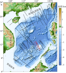
图1
南海区域地形及主要深地震测线位置[据丘学林等(2012)修改] 黑色实线为深地震测线, 红色实线为本研究的OBS2019-2测线。该图基于国家测绘地理信息局标准地图服务网下载的审图号为GS(2016)1609的标准地图制作"

图1
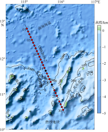
图2
南沙地块OBS2019-2测线位置与水深地形图 红色点为数据处理成功的站位, 黑色点为数据异常的站位, 白色点为仪器丢失的站位, 图中数字表示OBS站位编号"

图2
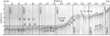
图3
同步采集的单道反射地震剖面及浅部地质解释 竖线表示OBS在剖面中的位置"
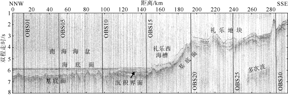
图3
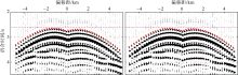
图4
OBS10台站直达水波震相位置校正前(a)和校正后(b)对比 折合速度为6.0km·s-1。图中红色点表示拾取的直达水波震相走时, 紫色虚线用于判断直达水波的对称性"
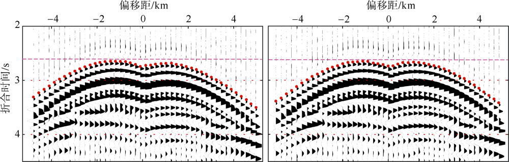
图4
表1
OBS2019-2测线OBS位置校正结果"
| 站位 编号 | OBS 编号 | 投放点位置 | 校正后位置 | 校正后 水深/m | RMS/ms | t_adjust/s | ||
|---|---|---|---|---|---|---|---|---|
| 经度/E | 纬度/N | 经度/E | 纬度/N | |||||
| 01 | A37 | 115°05′35.48″ | 12°49′05.95″ | 115°05′40.02″ | 12°49′06.31″ | 4360 | 2.6 | -3.033 |
| 02 | L26 | 115°07′43.72″ | 12°44′24.97″ | 115°07′51.46″ | 12°44′28.46″ | 4361 | 1.3 | -0.144 |
| 03 | S11 | 115°09′51.84″ | 12°39′43.92″ | 115°09′46.73″ | 12°39′40.97″ | 4363 | 1.8 | -0.117 |
| 04 | L23 | 115°12′00.40″ | 12°35′03.62″ | 115°11′48.66″ | 12°34′58.58″ | 4358 | 3.4 | -0.124 |
| 05 | L85 | 115°14′07.84″ | 12°30′21.82″ | 115°14′09.71″ | 12°30′20.84″ | 4360 | 1.2 | -1.157 |
| 06 | B41 | 115°16′15.74″ | 12°25′40.76″ | 115°16′11.39″ | 12°25′40.58″ | 4357 | 1.4 | -0.011 |
| 07 | L54 | 115°18′23.54″ | 12°20′59.68″ | 115°18′19.80″ | 12°20′59.53″ | 4359 | 1.5 | -0.144 |
| 08 | L16 | 115°20′31.31″ | 12°16′18.55″ | 115°20′44.09″ | 12°16′24.71″ | 4357 | 1.9 | -0.126 |
| 09 | H56 | 115°22′38.96″ | 12°11′37.43″ | 115°22′24.17″ | 12°11′32.75″ | 4357 | 1.5 | -0.108 |
| 10 | L17 | 115°24′46.55″ | 12°06′56.30″ | 115°24′48.20″ | 12°07′00.08″ | 4359 | 1.9 | -0.130 |
| 11 | B29 | 115°26′54.06″ | 12°02′15.14″ | 115°26′31.38″ | 12°02′07.55″ | 4369 | 3.1 | -2.928 |
| 12 | L94 | 115°29′01.50″ | 11°57′33.95″ | 115°28′58.40″ | 11°57′33.95″ | 4326 | 0.7 | -1.115 |
| 13 | L96 | 115°31′08.87″ | 11°52′52.75″ | 115°31′09.48″ | 11°52′54.84″ | 4328 | 2.2 | -0.111 |
| 14 | L93 | 115°33′16.16″ | 11°48′11.56″ | 115°33′22.93″ | 11°48′14.18″ | 4321 | 1.7 | -0.122 |
| 15 | L35 | 115°35′23.39″ | 11°43′30.32″ | 115°35′12.37″ | 11°43′25.46″ | 4332 | 2.0 | -0.028 |
| 17 | B87 | 115°39′37.62″ | 11°34′07.86″ | 115°39′22.03″ | 11°34′00.05″ | 4070 | 2.3 | -0.027 |
| 18 | L70 | 115°41′45.31″ | 11°29′27.67″ | 115°41′31.38″ | 11°29′21.12″ | 3936 | 1.4 | -0.115 |
| 19 | L98 | 115°43′51.56″ | 11°24′45.29″ | 115°44′03.70″ | 11°24′49.57″ | 3104 | 3.3 | -0.076 |
| 20 | L95 | 115°45′58.43″ | 11°20′03.98″ | 115°45′38.92″ | 11°19′55.81″ | 2700 | 1.8 | -0.093 |
| 23 | B40 | 115°52′18.59″ | 11°05′60.00″ | 115°52′18.84″ | 11°06′00.07″ | 2142 | 4.2 | 0.039 |
| 24 | L31 | 115°54′25.20″ | 11°01′18.66″ | 115°53′52.12″ | 11°01′04.76″ | 2675 | 5.2 | -2.093 |
| 25 | L64 | 115°56′31.70″ | 10°56′37.28″ | 115°56′36.89″ | 10°56′40.06″ | 2350 | 5.5 | -0.099 |
| 27 | D28 | 116°00′44.57″ | 10°47′14.50″ | 116°00′43.31″ | 10°47′14.32″ | 2114 | 3.1 | -0.192 |
| 28 | L89 | 116°02′50.89″ | 12°49′05.95″ | 116°02′50.82″ | 10°42′33.16″ | 2228 | 3.5 | -1.893 |
| 29 | H52 | 116°04′57.14″ | 12°44′24.97″ | 116°04′43.25″ | 10°37′45.48″ | 2103 | 2.1 | 0.068 |
| 30 | L99 | 116°07′03.07″ | 12°39′43.92″ | 116°07′02.82″ | 10°33′09.86″ | 1794 | 3.9 | 0.054 |
表1
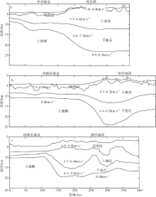
图5
OBS2019-2邻近测线的地壳结构剖面 a. OBS973-2测线的地壳结构剖面[据阮爱国等(2011)]; b. OBS973-1测线的地壳结构剖面[据丘学林等(2011)]; c. CFT-OBS2011测线南沙地块区域的地壳结构剖面[据Pichot等(2014)]"
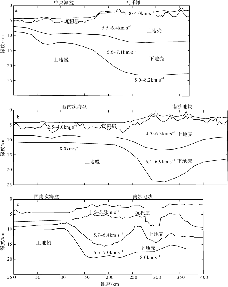
图5
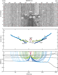
图6
OBS11台站垂直分量的震相识别与射线追踪 a. 垂直分量综合地震记录剖面与震相识别(折合速度为6.0km·s-1); b. 震相走时拟合情况(黑色细线表示理论计算走时, 彩色粗线表示实际拾取走时); c. 初始纵波速度模型与射线追踪"

图6

图7
OBS14台站垂直分量综合地震记录剖面与震相识别 a. 垂直分量综合地震记录剖面与震相识别(折合速度为6.0km·s-1); b. 震相走时拟合情况(黑色细线表示理论计算走时, 彩色粗线表示实际拾取走时); c. 初始纵波速度模型与射线追踪"
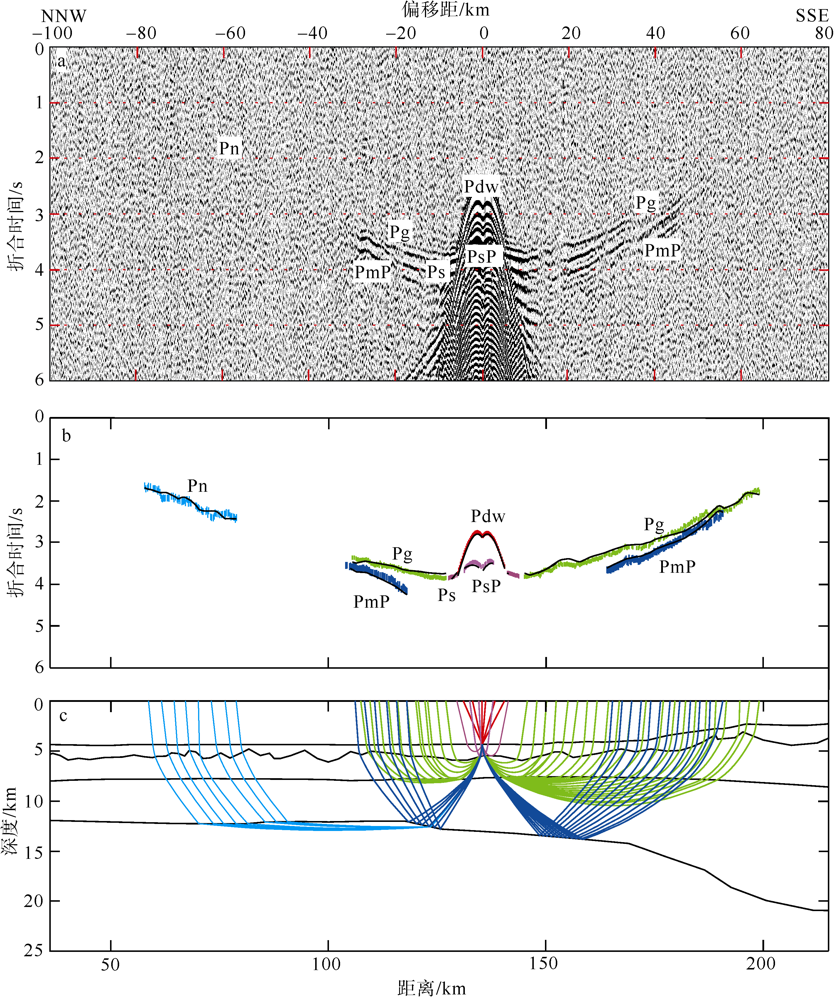
图7
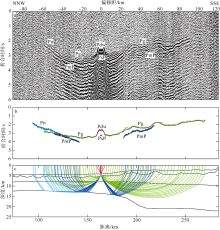
图8
OBS17台站垂直分量综合地震记录剖面与震相识别 a. 垂直分量综合地震记录剖面与震相识别(折合速度为6.0km·s-1); b. 震相走时拟合情况(黑色细线表示理论计算走时, 彩色粗线表示实际拾取走时); c. 初始纵波速度模型与射线追踪"

图8

图9
OBS23台站垂直分量综合地震记录剖面与震相识别 a. 垂直分量综合地震记录剖面与震相识别(折合速度为6.0km·s-1); b. 震相走时拟合情况(黑色细线表示理论计算走时, 彩色粗线表示实际拾取走时); c. 初始纵波速度模型与射线追踪"

图9
| [1] | 敖威, 赵明辉, 丘学林, 等, 2010. 西南印度洋中脊三维地震探测中炮点与海底地震仪的位置校正[J]. 地球物理学报, 53(12): 2982-2991. |
| AO WEI, ZHAO MINGHUI, QIU XUELIN, et al, 2010. The correction of shot and OBS position in the 3D seismic experiment of the SW Indian Ocean Ridge[J]. Chinese Journal of Geophysics, 53(12): 2982-2991. (in Chinese with English abstract) | |
| [2] | 丁巍伟, 李家彪, 黎明碧, 2011. 南海南部陆缘礼乐盆地新生代的构造-沉积特征及伸展机制: 来自NH973-2多道地震测线的证据[J]. 地球科学—中国地质大学学报, 36(5): 895-904. |
| DING WEIWEI, LI JIABIAO, LI MINGBI, 2011. Seismic stratigraphy, tectonic structure and extension model across the Reed Bank Basin in the south margin of South China Sea: evidence from NH973-2 multichannel seismic profile[J]. Earth Science — Journal of China University of Geosciences, 36(5): 895-904. (in Chinese with English abstract) | |
| [3] | 郭晓然, 赵明辉, 黄海波, 等, 2016. 西沙地块地壳结构及其构造属性[J]. 地球物理学报, 59(4): 1414-1425. |
| GUO XIAORAN, ZHAO MINGHUI, HUANG HAIBO, et al, 2016. Crustal structure of Xisha block and its tectonic attributes[J]. Chinese Journal of Geophysics, 59(4): 1414-1425. (in Chinese with English abstract) | |
| [4] | 郝天珧, 徐亚, 孙福利, 等, 2011. 南海共轭大陆边缘构造属性的综合地球物理研究[J]. 地球物理学报, 54(12): 3098-3116. |
| HAO TIANYAO, XU YA, SUN FULI, et al, 2011. Integrated geophysical research on the tectonic attribute of conjugate continental margin of South China Sea[J]. Chinese Journal of Geophysics, 54(12): 3098-3116. (in Chinese with English abstract) | |
| [5] | 黎雨晗, 黄海波, 丘学林, 等, 2020. 中沙海域的广角与多道地震探测[J]. 地球物理学报, 63(4): 1523-1537. |
| LI YUHAN, HUANG HAIBO, QIU XUELIN, et al, 2020. Wide-angle and multi-channel seismic surveys in Zhongsha waters[J]. Chinese Journal of Geophysics, 63(4): 1523-1537. (in Chinese with English abstract) | |
| [6] |
刘思青, 赵明辉, 张佳政, 等, 2017. 马尼拉海沟俯冲带前缘(21°N)海底地震仪数据处理初步成果[J]. 热带海洋学报, 36(2): 60-69.
doi: 10.11978/2016058 |
| LIU SIQING, ZHAO MINGHUI, ZHANG JIAZHENG, et al, 2017. OBS seismic data processing of the Manila Trench subduction zone (21°N) and some preliminary results[J]. Journal of Tropical Oceanography, 36(2): 60-69. (in Chinese with English abstract) | |
| [7] | 马飞, 黄海波, 丘学林, 等, 2021. 浅层结构不确定性对广角地震走时正演模拟结果的影响——以西沙地块OBS2011-1测线为例[J]. 地球物理学报, 64(10): 3669-3684. |
| MA FEI, HUANG HAIBO, QIU XUELIN, et al, 2021. Influence of shallow structure uncertainty on wide-angle seismic traveltime forward modeling — A case study using OBS2011-1 on the Xisha Block[J]. Chinese Journal of Geophysics, 64(10): 3669-3684. (in Chinese with English abstract) | |
| [8] | 牛雄伟, 卫小冬, 阮爱国, 等, 2014. 海底广角地震剖面反演方法对比——以南海礼乐滩OBS剖面为例[J]. 地球物理学报, 57(8): 2701-2712. |
| NIU XIONGWEI, WEI XIAODONG, RUAN AIGUO, et al, 2014. Comparision of inversion method of wide angle Ocean Bottom Seismometer profile: a case study of profile OBS973-2 across Liyue Bank in the South China Sea[J]. Chinese Journal of Geophysics, 57(8): 2701-2712. (in Chinese with English abstract) | |
| [9] | 丘学林, 陈颙, 朱日祥, 等, 2007. 大容量气枪震源在海陆联测中的应用: 南海北部试验结果分析[J]. 科学通报, 52(4): 463-469. |
|
QIU XUELIN, CHEN YONG, ZHU RIXIANG, et al, 2007. The application of large volume airgun sources to the onshore-offshore seismic surveys: implication of the experimental results in northern South China Sea[J]. Chinese Science Bulletin, 52(4): 553-560.. (in Chinese with English abstract)
doi: 10.1007/s11434-007-0051-1 |
|
| [10] | 丘学林, 赵明辉, 敖威, 等, 2011. 南海西南次海盆与南沙地块的OBS探测和地壳结构[J]. 地球物理学报, 54(12): 3117-3128. |
| QIU XUELIN, ZHAO MINGHUI, AO WEI, et al, 2011. OBS survey and crustal structure of the Southwest Sub-basin and Nansha Block, South China Sea[J]. Chinese Journal of Geophysics, 54(12): 3117-3128. (in Chinese with English abstract) | |
| [11] |
丘学林, 赵明辉, 徐辉龙, 等, 2012. 南海深地震探测的重要科学进程: 回顾和展望[J]. 热带海洋学报, 31(3): 1-9.
doi: 10.11978/j.issn.1009-5470.2012.03.001 |
| QIU XUELIN, ZHAO MINGHUI, XU HUILONG, et al, 2012. Important processes of deep seismic surveys in the South China Sea: retrospection and expectation[J]. Journal of Tropical Oceanography, 31(3): 1-9. (in Chinese with English abstract) | |
| [12] | 阮爱国, 牛雄伟, 丘学林, 等, 2011. 穿越南沙礼乐滩的海底地震仪广角地震试验[J]. 地球物理学报, 54(12): 3139-3149. |
| RUAN AIGUO, NIU XIONGWEI, QIU XUELIN, et al, 2011. A wide angle ocean bottom seismometer profile across Liyue Bank, the southern margin of South China Sea[J]. Chinese Journal of Geophysics, 54(12): 3139-3149. (in Chinese with English abstract) | |
| [13] |
汪俊, 邱燕, 阎贫, 等, 2019. 跨南海西南次海盆OBS、多道地震与重力联合调查[J]. 热带海洋学报, 38(4): 81-90.
doi: 10.11978/2018108 |
|
WANG JUN, QIU YAN, YAN PIN, et al, 2019. A joint investigation using OBS, multi-channel seismic and gravity data across the Southwestern Sub-basin of the South China Sea[J]. Journal of Tropical Oceanography, 38(4): 81-90. (in Chinese with English abstract)
doi: 10.11978/2018108 |
|
| [14] |
汪品先, 2009. 南海——我国深海研究的突破口[J]. 热带海洋学报, 28(3): 1-4.
doi: 10.11978/j.issn.1009-5470.2009.03.001 |
| WANG PINXIAN, 2009. Toward scientific breakthrough in the South China Sea[J]. Journal of Tropical Oceanography, 28(3): 1-4. (in Chinese with English abstract) | |
| [15] | 王强, 丘学林, 赵明辉, 等, 2016. 南海海底地震仪异常数据的分析和处理[J]. 地球物理学报, 59(3): 1102-1112. |
| WANG QIANG, QIU XUELIN, ZHAO MINGHUI, et al, 2016. Analysis and processing on abnormal OBS data in the South China Sea[J]. Chinese Journal of Geophysics, 59(3): 1102-1112. (in Chinese with English abstract) | |
| [16] | 王强, 赵明辉, 张浩宇, 等, 2020. 基于重处理数据的南海西北次海盆地壳速度结构[J]. 中国科学: 地球科学, 50(11): 1553-1568. |
|
WAGN QIANG, ZHAO MINGHUI, ZHANG HAOYU, et al, 2020. Crustal velocity structure of the Northwest Sub-basin of the South China Sea based on seismic data reprocessing[J]. Science China: Earth Sciences, 63(11): 1791-1806.. (in Chinese with English abstract)
doi: 10.1007/s11430-020-9654-4 |
|
| [17] | 杨富东, 张佳政, 杜峰, 等, 2020. 三维OBS探测实验中炮点和OBS位置校正新方法[J]. 地球物理学报, 63(2): 766-777. |
| YANG FUDONG, ZHANG JIAZHENG, DU FENG, et al, 2020. A-new method for shots and OBSs’ relocation applying in three-dimensional seismic survey[J]. Chinese Journal of Geophysics, 63(2): 766-777. (in Chinese with English abstract) | |
| [18] | 姚伯初, 1996. 南海海盆新生代的构造演化史[J]. 海洋地质与第四纪地质, 16(2): 1-13. |
| YAO BOCHU, 1996. Tectonic evolution of the South China Sea in Cenozoic[J]. Marine Geology & Quaternary Geology, 16(2): 1-13. (in Chinese with English abstract) | |
| [19] | 张浩宇, 丘学林, 张佳政, 等, 2019. 国产海底地震仪的时间记录与原始数据精细校正[J]. 地球物理学报, 62(1): 172-182. |
| ZHANG HAOYU, QIU XUELIN, ZHANG JIAZHENG, et al, 2019. Time record and accurate correction of Chinese OBS raw data[J]. Chinese Journal of Geophysics, 62(1): 172-182. (in Chinese with English abstract) | |
| [20] | 张佳政, 丘学林, 赵明辉, 等, 2018. 南海巴士海峡三维OBS探测的异常数据恢复[J]. 地球物理学报, 61(4): 1529-1538. |
| ZHANG JIAZHENG, QIU XUELIN, ZHAO MINGHUI, et al, 2018. Abnormal data retrieval of three-dimensional OBS survey at the Bashi Channel area of the South China Sea[J]. Chinese Journal of Geophysics, 61(4): 1529-1538. (in Chinese with English abstract) | |
| [21] | 张莉, 赵明辉, 王建, 等, 2013. 南海中央次海盆OBS位置校正及三维地震探测新进展[J]. 地球科学—中国地质大学学报, 38(1): 33-42. |
|
ZAHNG LI, ZAHO MINGHUI, WANG JIAN, et al, 2013. Correction of OBS position and recent advances of 3D seismic exploration in the Central Sub-basin of South China Sea[J]. Earth Science — Journal of China University of Geosciences, 38(1): 33-42. (in Chinese with English abstract)
doi: 10.3799/dqkx.2013.004 |
|
| [22] | 赵明辉, 丘学林, 夏戡原, 等, 2004. 南海东北部海陆联测地震数据处理及初步结果[J]. 热带海洋学报, 23(1): 58-63. |
| ZHAO MINGHUI, QIU XUELIN, XIA KANYUAN, et al, 2004. Onshore-offshore seismic data processing and preliminary results in NE South China Sea[J]. Journal of Tropical Oceanography, 23(1): 58-63. (in Chinese with English abstract) | |
| [23] | 赵明辉, 丘学林, 夏少红, 等, 2008. 大容量气枪震源及其波形特征[J]. 地球物理学报, 51(2): 558-565. |
|
ZHAO MINGHUI, QIU XUELIN, XIA SHAOHONG, et al, 2008. Large volume air-gun sources and its seismic waveform characters[J]. Chinese Journal of Geophysics, 51(2): 558-565. (in Chinese with English abstract)
doi: 10.1002/cjg2.1246 |
|
| [24] | BRIAIS A, PATRIAT P, TAPPONNIER P, 1993. Updated interpretation of magnetic anomalies and seafloor spreading stages in the South China Sea: implications for the Tertiary tectonics of Southeast Asia[J]. Journal of Geophysical Research: Solid Earth, 98(B4): 6299-6328. |
| [25] |
DU FENG, ZHANG JIAZHENG, YANG FUDONG, et al, 2018. Combination of least square and monte carlo methods for OBS relocation in 3D seismic survey near Bashi Channel[J]. Marine Geodesy, 41(5): 494-515.
doi: 10.1080/01490419.2018.1479993 |
| [26] |
FULLER M, ALI J R, MOSS S J, et al, 1999. Paleomagnetism of Borneo[J]. Journal of Asian Earth Sciences, 17(1-2): 3-24.
doi: 10.1016/S0743-9547(98)00057-9 |
| [27] |
HOU WENAI, LI CHUNFENG, WAN XIAOLI, et al, 2019. Crustal S-wave velocity structure across the northeastern South China Sea continental margin: implications for lithology and mantle exhumation[J]. Earth and Planetary Physics, 3(4): 314-329.
doi: 10.26464/epp2019033 |
| [28] |
HUANG HAIBO, QIU XUELIN, PICHOT T, et al, 2019. Seismic structure of the northwestern margin of the South China Sea: implication for asymmetric continental extension[J]. Geophysical Journal International, 218(2): 1246-1261.
doi: 10.1093/gji/ggz219 |
| [29] |
LI YUHAN, HUANG HAIBO, GREVEMEYER I, et al, 2021. Crustal structure beneath the Zhongsha Block and the adjacent abyssal basins, South China Sea: new insights into rifting and initiation of seafloor spreading[J]. Gondwana Research, 99: 53-76.
doi: 10.1016/j.gr.2021.06.015 |
| [30] | LIU SIQING, ZHAO MINGHUI, SIBUET J C, et al, 2018. Geophysical constraints on the lithospheric structure in the northeastern South China Sea and its implications for the South China Sea geodynamics[J]. Tectonophysics, 742-743: 101-119. |
| [31] |
LIU YUTAO, LI CHUNFENG, WEN YONGLIN, et al, 2021. Mantle serpentinization beneath a failed rift and post- spreading magmatism in the northeastern South China Sea margin[J]. Geophysical Journal International, 225(2): 811-828.
doi: 10.1093/gji/ggab006 |
| [32] |
MJELDE R, RAUM T, MURAI Y, et al, 2007. Continent - ocean-transitions: review, and a new tectono-magmatic model of the Vøring Plateau, NE Atlantic[J]. Journal of Geodynamics, 43(3): 374-392.
doi: 10.1016/j.jog.2006.09.013 |
| [33] |
PICHOT T, DELESCLUSE M, CHAMOT-ROOKE N, et al, 2014. Deep crustal structure of the conjugate margins of the SW South China Sea from wide-angle refraction seismic data[J]. Marine and Petroleum Geology, 58: 627-643.
doi: 10.1016/j.marpetgeo.2013.10.008 |
| [34] | RU K, PIGOTT J D, 1986. Episodic rifting and subsidence in the South China Sea[J]. AAPG Bulletin, 70(9): 1136-1155. |
| [35] |
SUN ZHEN, ZHONG ZHIHONG, KEEP M, et al, 2009. 3D analogue modeling of the South China Sea: a discussion on breakup pattern[J]. Journal of Asian Earth Sciences, 34(4): 544-556.
doi: 10.1016/j.jseaes.2008.09.002 |
| [36] | TAYLOR B, HAYES D E, 1980. The tectonic evolution of the South China Basin[M]//HAYES D E. The tectonic and geologic evolution of Southeast Asian Seas and Islands. Washington: American Geophysical Union: 89-104. |
| [37] | TAYLOR B, HAYES D E, 1983. Origin and history of the South China Sea basin[M]//HAYES D E. The tectonic and geologic evolution of Southeast Asian Seas and Islands: part 2. Washington: American Geophysical Union:23-56. |
| [38] |
WAN KUIYUAN, XIA SHAOHONG, CAO JINGHE, et al, 2017. Deep seismic structure of the northeastern South China Sea: origin of a high-velocity layer in the lower crust[J]. Journal of Geophysical Research: Solid Earth, 122(4): 2831-2858.
doi: 10.1002/2016JB013481 |
| [39] |
WAN XIAOLI, LI CHUNFENG, ZHAO MINGHUI, et al, 2019. Seismic velocity structure of the magnetic quiet zone and continent - ocean boundary in the northeastern South China Sea[J]. Journal of Geophysical Research: Solid Earth, 124(11): 11866-11899.
doi: 10.1029/2019JB017785 |
| [40] |
WEI XIAODONG, RUAN AIGUO, DING WEIWEI, et al, 2020. Crustal structure and variation in the southwest continental margin of the South China Sea: evidence from a wide-angle seismic profile[J]. Journal of Asian Earth Sciences, 203: 104557.
doi: 10.1016/j.jseaes.2020.104557 |
| [41] |
WHITMARSH R B, MANATSCHAL G, MINSHULL T A, 2001. Evolution of magma-poor continental margins from rifting to seafloor spreading[J]. Nature, 413(6852): 150-154.
doi: 10.1038/35093085 |
| [42] |
ZHAO MINGHUI, QIU XUELIN, XIA SHAOHONG, et al, 2010. Seismic structure in the northeastern South China Sea: S-wave velocity and Vp/Vs ratios derived from three-component OBS data[J]. Tectonophysics, 480(1-4): 183-197.
doi: 10.1016/j.tecto.2009.10.004 |
| [1] | 赵明辉, 袁野, 张佳政, 张翠梅, 高金尉, 王强, 孙珍, 程锦辉. 南海北部被动陆缘洋陆转换带张裂-破裂研究新进展[J]. 热带海洋学报, 2024, 43(2): 173-183. |
| [2] | 郭晓然, 刘善虎. 台湾海峡OBS地震记录中二次Ps震相的特征及应用[J]. 热带海洋学报, 2022, 41(5): 57-63. |
| [3] | 张浩宇, 丘学林, 黄海波. 主动源海底地震仪横波模型的自动搜索与非唯一性分析*[J]. 热带海洋学报, 2022, 41(1): 194-203. |
| [4] | 苏晓康, 赵明辉, 李子正, 袁野, 王星月, 程锦辉, 张佳政. 南海北部陆缘OBS2018-H2测线地壳结构初步结果*[J]. 热带海洋学报, 2021, 40(5): 111-122. |
| [5] | 任自强, 施小斌, 王晓芳, 赵鹏, 谌永强. 南海南沙海槽深部热状态及其构造意义[J]. 热带海洋学报, 2021, 40(4): 98-109. |
| [6] | 赵明辉, 程锦辉, 高金尉, 孙龙涛, 徐亚, 张佳政, 杜峰. 南海东部马尼拉俯冲带深部结构新认识*[J]. 热带海洋学报, 2021, 40(3): 25-33. |
| [7] | 邢涛, 詹文欢, 李福元, 陈玺. 东沙海域复杂海况下单源单缆长排列地震资料处理*[J]. 热带海洋学报, 2020, 39(4): 91-99. |
| [8] | 金震, 郭晓然, 陈方颖. 国产OBS的时间矫正方法——以2019年台湾海峡地壳结构海陆探测实验为例[J]. 热带海洋学报, 2020, 39(3): 42-48. |
| [9] | 李子正, 丘学林, 邢磊. 基于OBS和MCS数据的水合物地层速度特征[J]. 热带海洋学报, 2020, 39(2): 25-34. |
| [10] | 杨碧峰, 熊成, 曹敬贺, 孙金龙, 万奎元, 夏少红. 滑行波震相对珠江口地区壳内低速层的约束作用[J]. 热带海洋学报, 2020, 39(1): 106-119. |
| [11] | 王强, 赵明辉, 张佳政, 孙龙涛, 丘学林. 南海IODP 367-368钻探区深地震探测的OBS站位设计分析[J]. 热带海洋学报, 2018, 37(1): 90-97. |
| [12] | 李亚清, 阎贫, 王彦林, 钟广见. 东沙群岛西南海区海底地震测线OBS2015-1揭示的深部地壳结构*[J]. 热带海洋学报, 2017, 36(5): 83-92. |
| [13] | 王建, 赵明辉, 张佳政, 贺恩远, 丘学林. 海底地形校正在正确拾取OBS震相中的重要作用*[J]. 热带海洋学报, 2017, 36(5): 93-100. |
| [14] | 吕作勇, 丘学林, 叶春明, 孙金龙, 段永红, 吕金水. 珠江口区域海陆联合三维地震构造探测的数据处理与震相识别*[J]. 热带海洋学报, 2017, 36(3): 80-85. |
| [15] | 刘思青, 赵明辉, 张佳政, 孙龙涛, 徐亚, 詹文欢, 丘学林. 马尼拉海沟俯冲带前缘(21°N)海底地震仪数据处理初步成果*[J]. 热带海洋学报, 2017, 36(2): 60-69. |
|
||