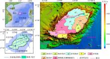
| [1] |
陈俊锦, 张经纬, 刘时桥, 等, 2022. 南海中沙群岛海域表层沉积物粒度特征及其输运趋势[J]. 海洋地质与第四纪地质, 42(2): 15-27.
|
|
CHEN JUNJIN, ZHANG JINWEI, LIU SHIQIAO, et al, 2022. Grain size distribution pattern of surface sediments and its implications for transportation trend: A case from the waters off Zhongsha islands, the South China Sea[J]. Marine Geology & Quaternary Geology, 42(2): 15-27. (in Chinese with English abstract)
|
| [2] |
陈梅, 夏真, 刘文涛, 等, 2022. 南海宣德环礁东南海域地质灾害特征[J]. 热带海洋学报, 41(2): 103-111.
doi: 10.11978/2021046
|
|
CHEN MEI, XIA ZHEN, LIU WENTAO, et al, 2022. Geohazards characteristics in the southeast of Xuande atoll, Xisha, South China Sea[J]. Journal of Tropical Oceanography, 41(2): 103-111. (in Chinese with English abstract)
doi: 10.11978/2021046
|
| [3] |
海南省地方志办公室, 2010. 海南省志. 自然地理志[M]. 海南出版社. (in Chinese)
|
| [4] |
胡进军, 徐长琦, 谢礼立, 等, 2018. 南海岛礁场地地震稳定性研究中的关键问题探讨[J]. 地震工程学报, 40(2): 279-287.
|
|
HU JINJUN, XU CHANGQI, XIE LILI, et al, 2018. Key issues in seismic stability analysis of reef sites in South China Sea[J]. China Earthquake Engineering Journal, 40(2): 279-287. (in Chinese with English abstract)
|
| [5] |
金宗川, 2018. 钙质砂的休止角研究与工程应用[J]. 岩土力学, 39(7): 2583-2590.
|
|
JIN ZONGCHUANG, 2018. Study of natural repose angle of calcareous sand and engineering application[J]. Rock and Soil Mechanics, 39(7): 2583-2590. (in Chinese with English abstract)
|
| [6] |
李军, 周成虎, 2003. 基于栅格GIS滑坡风险评价方法中格网大小选取分析[J]. 遥感学报, (2): 86-92.
|
|
LI JUN, ZHOU CHENGHU, 2003. Appropriate grid size for terrain based landslide risk assessment in Lantau island, Hong Kong[J]. Journal of Remote Sensing, (2): 86-92. (in Chinese with English abstract)
|
| [7] |
李学杰, 王大伟, 吴时国, 等, 2017. 三沙海底峡谷识别与地貌特征分析[J]. 海洋地质与第四纪地质, 37(3): 28-36.
|
|
LI XUEJIE, WANG DAWEI, WU SHIGUO, et al, 2017. Geomorphology of Sansha canyon: identification and implication[J]. Marine Geology & Quaternary Geology, 37(3): 28-36. (in Chinese with English abstract)
|
| [8] |
黎雨晗, 黄海波, 丘学林, 等, 2020. 中沙海域的广角与多道地震探测[J]. 地球物理学报, 63(4): 1523-1537.
|
|
LI YUHAN, HUANG HAIBO, QIU XUELIN, et al, 2020. Wide-angle and multi-channel seismic surveys in Zhongsha waters[J]. Chinese Journal of Geophysics, 63(4): 1523-1537. (in Chinese with English abstract)
|
| [9] |
刘韶, 1987. 中沙群岛礁湖沉积特征的探讨—兼论礁湖的地貌单元[J]. 海洋学报(中文版), 9(6): 794-797. (in Chinese)
|
| [10] |
任恒妮, 2019. 大数据K-means聚类算法的研究与应用[J]. 信息技术, 43(11): 20-23.
|
|
REN HENGNI, 2019. Research and application of big data K-means clustering algorithm[J]. Information Technology, 43(11): 20-23. (in Chinese with English abstract)
|
| [11] |
王千, 王成, 冯振元, 等, 2012. K-means聚类算法研究综述[J]. 电子设计工程, 20(7): 21-24.
|
|
WANG QIAN, WANG CHENG, FENG ZHENYUAN, et al, 2012. Review of K-means clustering algorithm[J]. Electronic Design Engineering, 20(7): 21-24. (in Chinese with English abstract)
|
| [12] |
吴夙慧, 成颖, 郑彦宁, 等, 2011. K-means算法研究综述[J]. 现代图书情报技术, 27(5): 28-35.
|
|
WU SUHUI, CHENG YING, ZHENG YANNING, et al, 2011. Survey on K-means Algorithm[J]. New Technology of Library and Information Service, 2011, 27(5): 28-35. (in Chinese with English abstract)
|
| [13] |
徐建华, 2002. 现代地理学中的数学方法[M]. 北京: 高等教育出版社:229-230.
|
|
XU JIANHUA, 2002. Mathematical methods in contemporary geography[M]. Beijing: Higher Education Press: 229-230. (in Chinese with English abstract)
|
| [14] |
徐子英, 汪俊, 高红芳, 等, 2020. 中沙地块南部断裂发育特征及其成因机制[J]. 中国地质, 47(5): 1438-1446.
|
|
XU ZIYING, WANG JUN, GAO HONGFANG, et al, 2020. The characteristics and formation mechanism of the faults in the southern part of the Zhongsha Bank[J]. Geology in China, 47(5): 1438-1446. (in Chinese with English abstract)
|
| [15] |
杨马陵, 魏柏林, 2020. 南海海域地震海啸潜在危险的探析[J]. 灾害学, 20(3): 41-47.
|
|
YANG MALING, WEI BAILIN, 2020. The potential seismic tsunami risk in South China Sea and it’s surrounding region[J]. Journal of Catastrophology, 20(3): 41-47. (in Chinese with English abstract)
|
| [16] |
余克服, 蒋明星, 程志强, 等, 2004. 涠洲岛42年来海面温度变化及其对珊瑚礁的影响[J]. 应用生态学报, 15(3): 506-510.
|
|
YU KEFU, JIANG MINGXING, CHENG ZHIQIANG, et al, 2004. Latest forty two years’ sea surface temperature change of Weizhou island and its influence on coral reef ecosystem[J]. Chinese Journal of Applied Ecology, 15(3): 506-510. (in Chinese with English abstract)
|
| [17] |
詹文欢, 詹美珍, 孙宗勋, 等, 2010. 雷州半岛西南部珊瑚礁礁体结构与场地稳定性分析[J]. 热带海洋学报, 29(3): 151-154.
|
|
ZHAN WENHUAN, ZHAN MEIZHEN, SUN ZONGXUN, et al, 2010. Rock mass structure and ground stability of coral reefs in the southwestern Leizhou peninsula[J]. Journal of Tropical Oceanography, 29(3): 151-154. (in Chinese with English abstract)
doi: 10.11978/j.issn.1009-5470.2010.03.151
|
| [18] |
赵焕庭, 王丽荣, 宋朝景, 2014. 南海珊瑚礁地貌模型研究[J]. 海洋学报, 36(9): 112-120.
|
|
ZHAO HUANGTING, WANG LIRONG, SONG CHAOJING, 2014. Geomorphological model of coral reefs in the South China Sea[J]. Acta Oceanologica Sinica, 36(9): 112-120. (in Chinese with English abstract)
doi: 10.1007/s13131-017-1047-8
|
| [19] |
周天伦, 曾超, 范晨, 等, 2021. 基于快速聚类-信息量模型的汶川及周边两县滑坡易发性评价[J]. 中国地质灾害与防治学报, 32(5): 137-150.
|
|
ZHOU TIANLUN, ZENG CHAO, FAN CHEN, et al, 2021. Landslide susceptibility assessment based on K-means cluster information model in Wenchuan and two neighboring counties, China[J]. The Chinese Journal of Geological Hazard and Control, 32(5): 137-150. (in Chinese with English abstract)
|
| [20] |
BALL G H, HALL J, 1965. Isodata, a novel method of data analysis and pattern classification[J]. Stanford Research Institute.
|
| [21] |
HUANG HAIBO, HE ENYUAN, QIU XUELIN, et al, 2020a. Insights about the structure and development of Zhongsha bank in the South China Sea from integrated geophysical modelling[J]. International Geology Review, 62(7-8): 1070-1080.
doi: 10.1080/00206814.2019.1653798
|
| [22] |
HUANG XIAOXIA, BETZLER C, WU SHIGUO, et al, 2020b. First documentation of seismic stratigraphy and depositional signatures of Zhongsha atoll (Macclesfield Bank), South China Sea[J]. Marine and Petroleum Geology, 117: 104349.
doi: 10.1016/j.marpetgeo.2020.104349
|
| [23] |
LI YUHAN, GREVEMEYER I, HUANG HAIBO, et al, 2022. Crustal compositional variations from continental to oceanic domain: A VP/ VS ratio study across the Zhongsha block, South China Sea[J]. Journal of Geophysical Research: Solid Earth, 127: e2021JB023470. Doi: 10.1029/2021JB023470.
doi: 10.1029/2021JB023470
|
| [24] |
LI YUHAN, HUANG HAIBO, GREVEMEYER I, et al, 2021. Crustal structure beneath the Zhongsha block and the adjacent abyssal basins, South China Sea: new insights into rifting and initiation of seafloor spreading[J]. Gondwana Research, 99(6): 53-76.
doi: 10.1016/j.gr.2021.06.015
|
| [25] |
MACQUEEN J B. 1967. Some methods for classification and analysis of multivariate observations[C]. In: Proceedings of the Fifth Berkeley Symposium on Mathematical Statistics and Probability. University of California Press.
|
| [26] |
REN ZHIYUAN, LIU HUA, 2015. Numerical study of potential extreme tsunami hazard in South China Sea[J]. Procedia Engineering, 126: 332-338.
doi: 10.1016/j.proeng.2015.11.201
|
| [27] |
WU SHIGUO, YANG ZHEN, WANG DAWEI, et al, 2014. Architecture, development and geological control of the Xisha carbonate platforms, northwestern South China Sea[J]. Marine Geology, 350: 71-83.
doi: 10.1016/j.margeo.2013.12.016
|

 ), 龙根元1,2(