
热带海洋学报 ›› 2026, Vol. 45 ›› Issue (2): 42-58.doi: 10.11978/2025104CSTR: 32234.14.2025104
长江口咸潮入侵格局变化及其成因
裘诚1( ), 朱宜平2, 朱建荣3()
- 1
上海市海洋监测预报中心
2上海城投原水有限公司
3河口海岸全国重点实验室(华东师范大学)
-
收稿日期:2025-07-14修回日期:2025-07-24出版日期:2026-03-10发布日期:2026-03-26 -
通讯作者:朱建荣。email: jrzhu@sklec.ecnu.edu.cn -
作者简介:裘诚(1987—), 男, 上海市人, 高级工程师, 从事河口海岸学研究。email: dieohacker@aliyun.com
-
基金资助:上海市科委重点项目(23DZ1203002); 国家自然科学基金项目(U2340225); 国家自然科学基金项目(42276174)
Changes and causes of saltwater intrusion patterns in the Changjiang Estuary
QIU Cheng1(), ZHU Yiping2, ZHU Jianrong3()
- 1
Shanghai Marine Monitoring and Forecasting Centre
2Shanghai Chengtou Raw Water Limited Company
3State Key Laboratory of Estuarine and Coastal Research (East China Normal University)
-
Received:2025-07-14Revised:2025-07-24Online:2026-03-10Published:2026-03-26 -
Contact:ZHU Jianrong. email: jrzhu@sklec.ecnu.edu.cn -
Supported by:Science and Technology Commission of Shanghai Municipality(23DZ1203002); National Natural Science Foundation of China(U2340225); National Natural Science Foundation of China(42276174)
摘要:
2007—2021年长江口重大圈围工程导致河道缩窄, 显著改变局部地形。文章利用2007—2025年的实测地形和盐度资料, 分析期间长江口河势变化和咸潮入侵格局变化, 并利用数值模式揭示格局变化的成因。由于工程致使长江口北支下段南侧发生严重淤积, 北支上端出现新生沙体, 导致北支下段和上端2021年的河槽容积比2007年分别减小了33.33%和13.26%。2007年和2025年枯季盐度观测资料表明, 北支咸潮入侵和北支盐水倒灌显著减弱, 而北港咸潮入侵在气候态风时减弱、强北风时加剧。月平均径流量和风作用的数值模拟结果表明, 从2007年至2021年, 咸潮入侵在北支大幅减弱, 在北港上段和中段大部分区域减弱, 在南港、北槽和南槽显著加剧; 北支盐水倒灌大幅减弱导致南支咸潮入侵减弱。2021年与2007年相比: 北支2月大潮、小潮期间纳潮量分别减小了2.88×10⁸m3、1.98×10⁸m3, 进入南支的净水通量分别减小了423m3·s-1、369m3·s-1, 盐分倒灌的净盐通量分别减小了10.06kg·s-1、1.10kg·s-1; 北支上段净单宽盐通量变化也说明北支盐分向南支输运大幅减小; 2007年北支盐水倒灌显著, 2021年几乎消失。北港2月大潮、小潮期间纳潮量分别减小了1.92×10⁸m3、1.86×10⁸m3, 净水通量分别增加了857m3·s-1、1379m3·s-1, 分流比分别增加了12.79%、7.79%, 向海的净盐通量减小了2.28kg·s-1、5.42kg·s-1。这些因素的变化解释了北港上段和中段大部分区域咸潮入侵减弱的原因。北港分流比的明显增加和相应的南港分流比减小说明了南港、北槽和南槽咸潮入侵加剧的成因。北港中段大潮期间小部分区域盐度上升是由横沙小港净盐通量从北槽向北港输运显著增加造成的。
中图分类号:
- P731.23
引用本文
裘诚, 朱宜平, 朱建荣. 长江口咸潮入侵格局变化及其成因[J]. 热带海洋学报, 2026, 45(2): 42-58.
QIU Cheng, ZHU Yiping, ZHU Jianrong. Changes and causes of saltwater intrusion patterns in the Changjiang Estuary[J]. Journal of Tropical Oceanography, 2026, 45(2): 42-58.
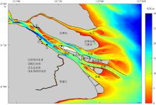
图1
长江口形势图 该图基于自然资源部标准地图服务网站下载的审图号为GS(2019)3266号的标准地图制作, 底图无修改。图中绿点为崇明东滩气象站; 黑点为水库取水口; 白色部分为水库区域; 北槽南北两侧的刻度线为导堤的丁坝"

图1
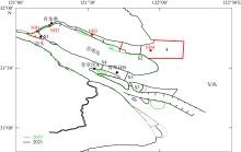
图2
长江口2007年和2021年岸线 该图基于自然资源部标准地图服务网站下载的审图号为GS(2019)3266号的标准地图制作, 底图无修改。图中黑点为青龙港、崇头、青草沙A、青草沙B测站; 红点为北支模式输出点NB1、NB2、NB3、NB4; 红线将北支划分为区域1、区域2、区域3和区域4; S1、S2为北支上段、下段横断面; S3、S4为北港中段、上段横断面; S5为横沙小港横断面"
图2
表1
长江口北支各区域河槽表面积变化(单位: m2)"
| 年份 | 区域1 | 区域2 | 区域3 | 区域4 |
|---|---|---|---|---|
| 2007 | 4.16×10⁷ | 4.31×10⁷ | 1.34×10⁸ | 5.33×10⁸ |
| 2021 | 3.99×10⁷ | 4.09×10⁷ | 1.03×10⁸ | 5.12×10⁸ |
| 变化率 | -4.26% | -5.38% | -30.10% | -4.10% |
表1
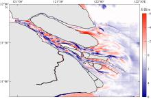
图3
2007年至2021年长江口水深变化 该图基于自然资源部标准地图服务网站下载的审图号为GS(2019)3266号的标准地图制作, 底图无修改。红色表示淤积; 蓝色表示侵蚀"

图3
表2
长江口北支各区域河槽容积变化(单位: m3)"
| 年份 | 区域1 | 区域2 | 区域3 | 区域4 |
|---|---|---|---|---|
| 2007 | 2.72×10⁸ | 1.16×10⁸ | 4.99×10⁸ | 3.16×10⁹ |
| 2021 | 2.04×10⁸ | 1.47×10⁸ | 4.45×10⁸ | 2.79×10⁹ |
| 变化率 | -33.33 % | +21.09 % | -12.13 % | -13.26 % |
表2
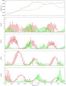
图4
2月15日—3月31日大通实测径流量(a)和青龙港(b)、崇头(c)、青草沙A (d)、青草沙B (e)测站表层盐度随时间变化曲线 图中红线为2007年; 绿线为2025年。图中虚线表示盐度0.45‰, 为饮用水盐度标准"
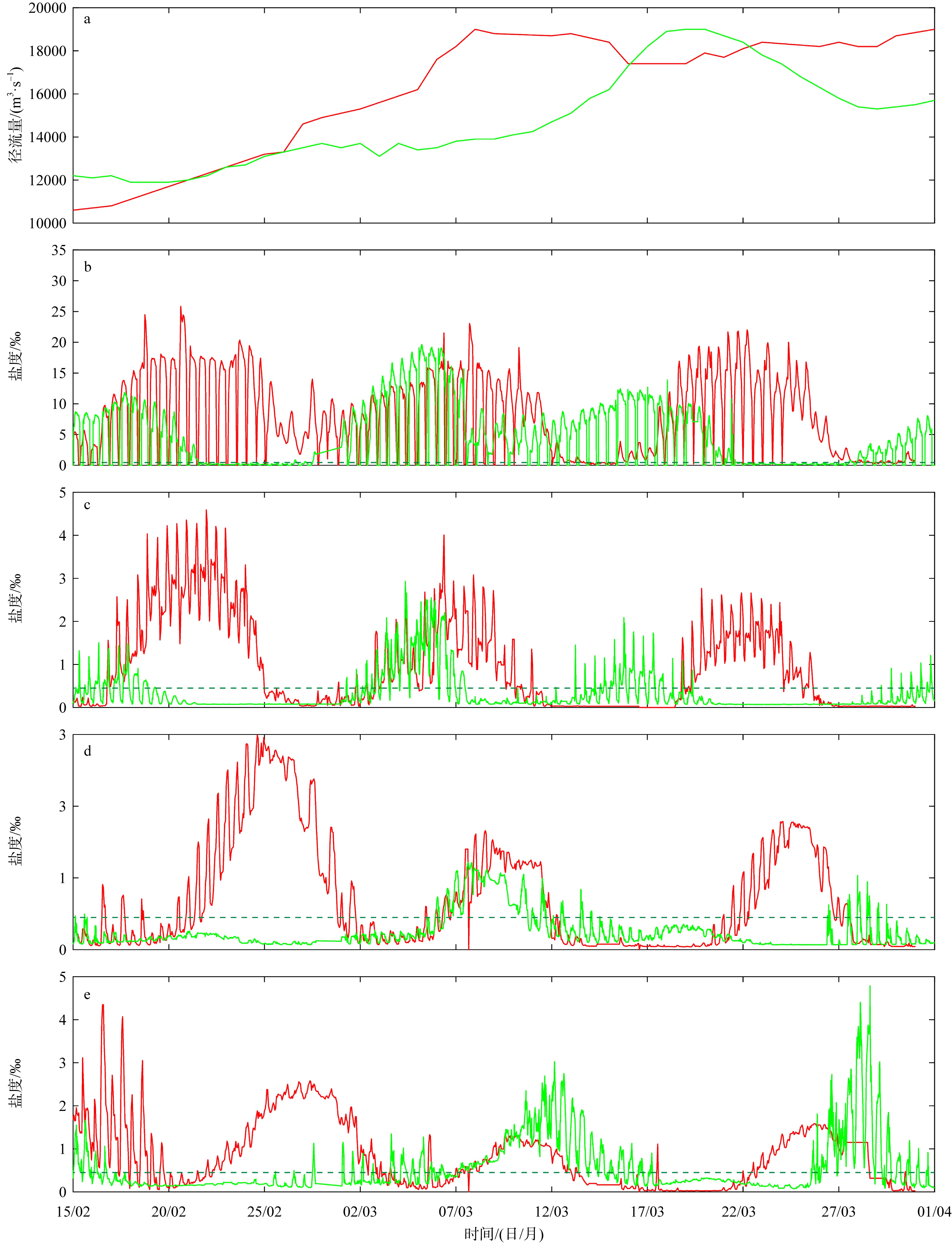
图4

图5
2007年(a)和2025年(b) 3月8—31日崇明东滩气象站风矢随时间变化"
图5
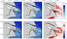
图6
2021年与2007年2月大潮和小潮期间的潮周期和垂向平均盐度分布以及2021年与2007年潮周期和垂向平均盐度差值分布 a. 2021年2月大潮; b. 2021年2月小潮; c. 2007年2月大潮; d. 2007年2月小潮; e. 2021年与2007年2月大潮盐度差值; f. 2021年与2007年2月小潮盐度差值。该图基于自然资源部标准地图服务网站下载的审图号为GS(2019)3266号的标准地图制作, 底图无修改"
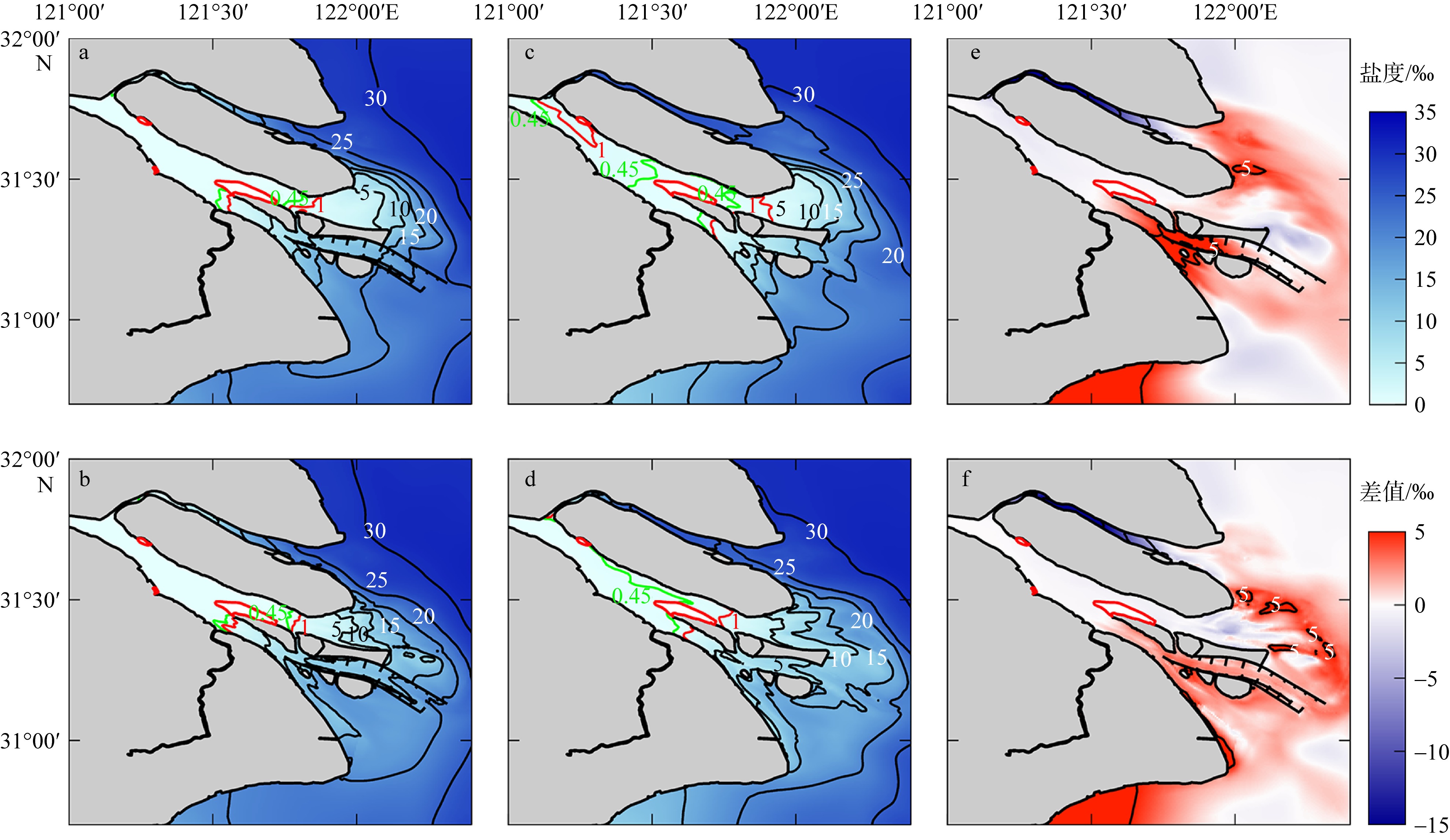
图6
图7
NB1 (a)、NB2 (b)、NB3 (c)和NB4 (d)输出点表层盐度随时间变化 图中红线为2021年; 黑线为2007年。绿色虚线表示盐度0.45‰"

图7
图8
东风西沙水库(a)、太仓水库(b)、陈行水库(c)和青草沙水库(d)取水口表层盐度随时间变化 图中红线为2021年; 黑线为2007年。绿色虚线表示盐度0.45‰"
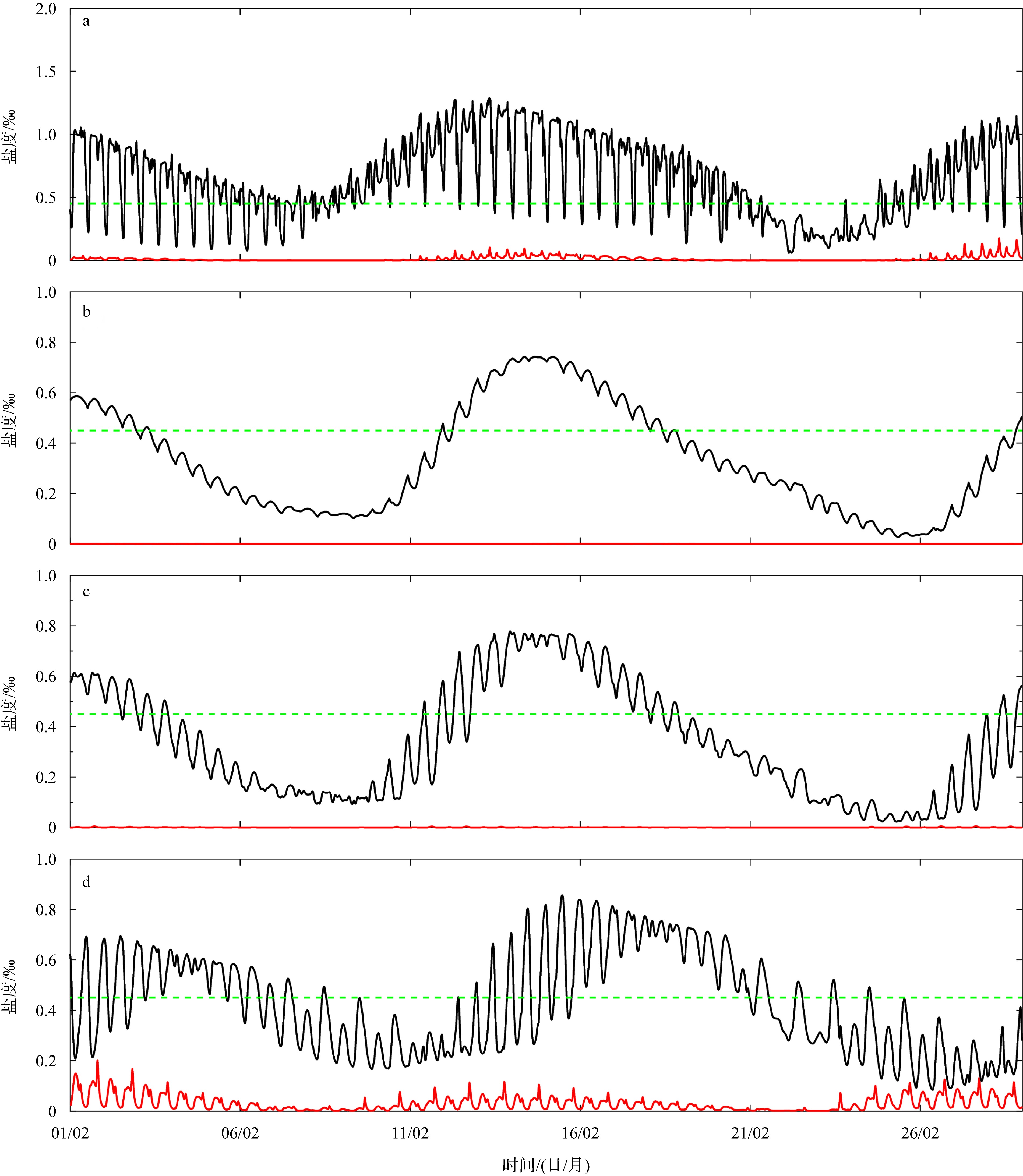
图8

图9
青龙港水文站2月潮位随时间变化"
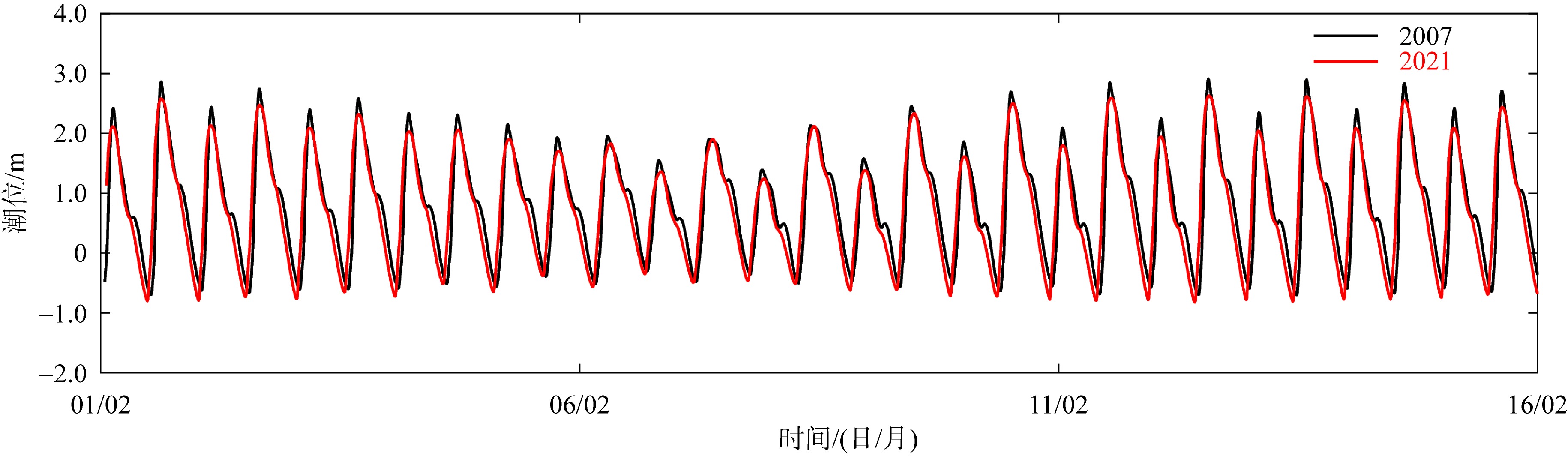
图9
表3
2007年和2021年2月份大潮、大潮后中潮、小潮、小潮后中潮和全潮期间通过北支横断面S1的净水通量、净盐通量和分流比"
| 统计时段 | 净水通量/(m3·s-1) | 净盐通量/(kg·s-1) | 分流比/% | |||
|---|---|---|---|---|---|---|
| 2021年 | 2007年 | 2021年 | 2007年 | 2021年 | 2007年 | |
| 大潮 | 49 | -374 | -0.01 | -10.07 | 0.41 | -3.07 |
| 大潮后中潮 | 249 | -226 | 0.00 | -5.56 | 1.77 | -1.68 |
| 小潮 | 445 | 76 | 0.00 | -1.10 | 3.03 | 0.55 |
| 小潮后中潮 | -2 | -446 | 0.00 | -9.02 | -0.02 | -4.06 |
| 全潮 | 173 | -224 | 0.00 | -5.94 | 1.36 | -1.81 |
表3
表4
2007年和2021年河势下通过北支横断面S2和北港横断面S3大潮、大潮后中潮、小潮、小潮后中潮和全潮期间纳潮量(单位: ×108m3)"
| 统计时段 | 北支 | 北港 | ||
|---|---|---|---|---|
| 2007 | 2021 | 2007 | 2021 | |
| 大潮 | 9.82 | 6.94 | 16.51 | 14.59 |
| 大潮后中潮 | 8.11 | 5.52 | 13.29 | 11.48 |
| 小潮 | 5.44 | 3.46 | 10.56 | 8.70 |
| 小潮后中潮 | 8.80 | 6.45 | 15.54 | 13.71 |
| 全潮 | 6.63 | 4.43 | 10.28 | 8.93 |
表4
图10
2021年(a、b)和2007年(c、d)2月大潮期间(a、c)和小潮期间(b、d)北支上端区域单宽水通量平面分布 该图基于自然资源部标准地图服务网站下载的审图号为GS(2019)3266号的标准地图制作, 底图无修改"
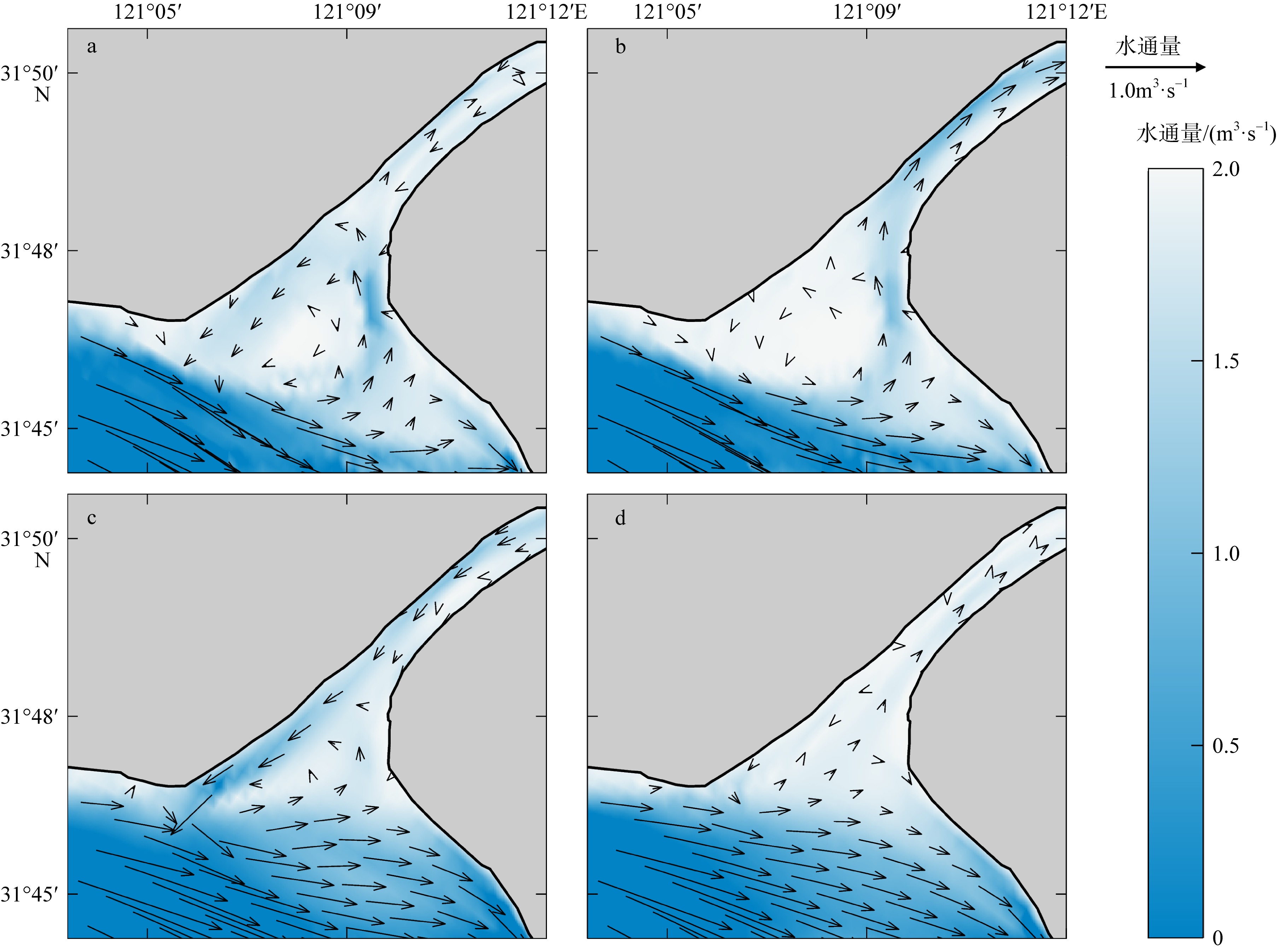
图10
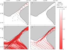
图11
2021年(a、b)和2007年(c、d) 2月大潮期间(a、c)和小潮期间(b、d)北支上端区域单宽盐通量平面分布 该图基于自然资源部标准地图服务网站下载的审图号为GS(2019)3266号的标准地图制作, 底图无修改"
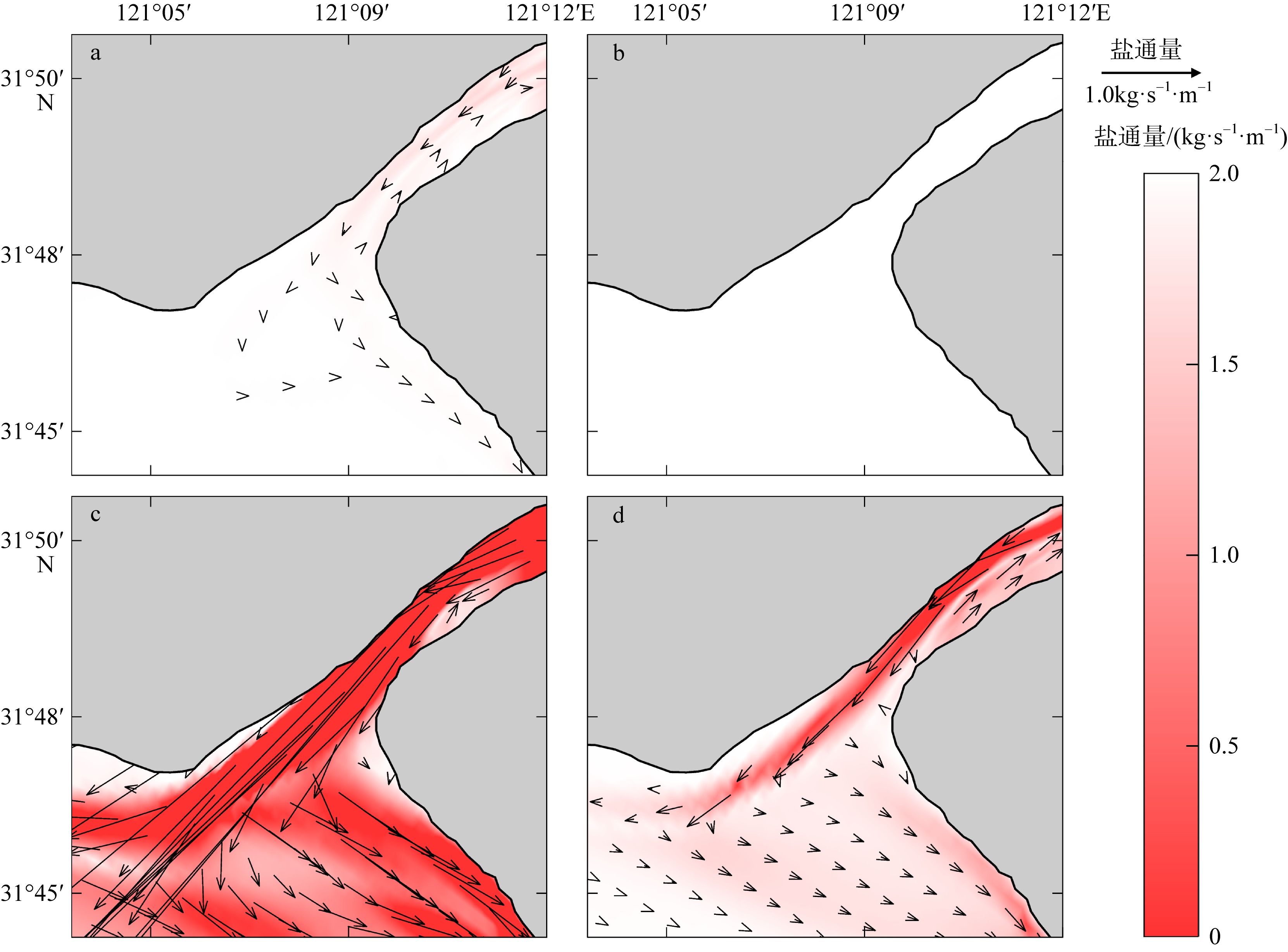
图11
表5
2007年和2021年2月份大潮、大潮后中潮、小潮、小潮后中潮和全潮期间通过北港横断面S4的净水通量、净盐通量和分流比"
| 统计时段 | 净水通量/(m3·s-1) | 净盐通量/(kg·s-1) | 分流比/% | |||
|---|---|---|---|---|---|---|
| 2021 | 2007 | 2021 | 2007 | 2021 | 2007 | |
| 大潮 | 8611 | 7754 | 0.18 | 2.46 | 73.53 | 60.74 |
| 大潮后中潮 | 10118 | 8759 | 0.18 | 7.03 | 70.50 | 60.55 |
| 小潮 | 10938 | 9559 | 0.09 | 5.51 | 69.40 | 61.61 |
| 小潮后中潮 | 5708 | 5567 | 0.17 | 1.46 | 63.52 | 55.22 |
| 全潮 | 8693 | 7660 | 0.16 | 4.11 | 68.74 | 58.90 |
表5
表6
2007年和2021年2月份大潮、大潮后中潮、小潮、小潮后中潮和全潮期间通过横沙通道横断面S5的净水通量和净盐通量"
| 统计时段 | 净水通量/(m3·s-1) | 净盐通量/(kg·s-1) | ||
|---|---|---|---|---|
| 2021 | 2007 | 2021 | 2007 | |
| 大潮 | -2041 | -393 | -17.65 | -2.84 |
| 大潮后中潮 | -1859 | -94 | -15.69 | -2.07 |
| 小潮 | -1122 | -412 | -11.19 | -4.24 |
| 小潮后中潮 | -1367 | -230 | -10.62 | -3.62 |
| 全潮 | -1566 | -226 | -13.59 | -2.99 |
表6
| [1] |
陈泾, 朱建荣, 2014. 长江河口青草沙水库盐水入侵来源[J]. 海洋学报(中文版), 36(11): 131-141.
|
|
doi: 10.1007/s13131-017-1026-y |
|
| [2] |
顾靖华, 朱建荣, 裘诚, 等, 2021. 长江河口盐水入侵长期演变分析[J]. 华东师范大学学报(自然科学版), (6): 174-186.
|
|
|
|
| [3] |
海洋图集编委会, 1992. 渤海黄海东海海洋图集(水文)[M]. 北京:海洋出版社:13-168.
|
|
EDITORIAL BOARD FOR MARINE ATLAS, 1992. Ocean atlas in Huanghai Sea and East China Sea (Hydrology)[M]. Beijing: China Ocean Press: 13-168 (in Chinese).
|
|
| [4] |
韩乃斌, 1983. 长江口南支河段氯度变化分析[J]. 水利水运科学研究, (1): 74-81.
|
|
|
|
| [5] |
李林江, 朱建荣, 2021. 冬季北风风速对长江河口盐水入侵的影响[J]. 海洋学报, 43(10): 10-22.
|
|
|
|
| [6] |
李林江, 朱建荣, 2015. 长江口南汇边滩围垦工程对流场和盐水入侵的影响[J]. 华东师范大学学报(自然科学版), (4): 77-86.
|
|
|
|
| [7] |
李志鹏, 朱建荣, 2022. 2007—2016年北支河势变化对长江口盐水入侵影响数值研究[J]. 华东师范大学学报(自然科学版), (3): 109-124.
|
|
|
|
| [8] |
陆佳玉, 葛建忠, 丁平兴, 2020. 潮控型分汊河口分流过程探讨: 以长江北支口为例[J]. 华东师范大学学报(自然科学版), (3): 1-12.
|
|
|
|
| [9] |
仇威, 朱建荣, 2023. 持续强北风天气下长江口盐水入侵对径流量的响应[J]. 华东师范大学学报(自然科学版), (3): 132-146.
|
|
|
|
| [10] |
沈焕庭, 茅志昌, 谷国传, 等, 1980. 长江口盐水入侵的初步研究—兼谈南水北调[J]. 人民长江, 11(3): 20-26.
|
|
|
|
| [11] |
沈焕庭, 茅志昌, 朱建荣, 2003. 长江河口盐水入侵[M]. 北京: 海洋出版社.
|
|
|
|
| [12] |
吴辉, 朱建荣, 2007. 长江河口北支倒灌盐水输送机制分析[J]. 海洋学报, 29(1): 17-25.
|
|
doi: 10.1007/s13131-010-0003-5 |
|
| [13] |
朱建荣, 鲍道阳, 2016. 近60年来长江河口河势变化及其对水动力和盐水入侵的影响Ⅰ. 河势变化[J]. 海洋学报, 38(12): 11-22.
|
|
|
|
| [14] |
朱建荣, 鲁佩仪, 唐川敏, 等, 2020. 长江河口北支建闸对减轻盐水入侵的数值模拟[J]. 华东师范大学学报(自然科学版), (3): 13-22.
|
|
|
|
| [15] |
朱建荣, 吕行行, 2019. 长江河口下扁担沙水域最长连续不宜取水时间[J]. 海洋学报, 41(6): 12-22.
|
|
|
|
| [16] |
朱建荣, 吴辉, 顾玉亮, 2011. 长江河口北支倒灌盐通量数值分析[J]. 海洋学研究, 29(3): 1-7.
|
|
|
|
| [17] |
朱宜平, 2021. 长江口青草沙水域外海正面盐水入侵特点分析[J]. 华东师范大学学报(自然科学版), (2): 21-29.
|
|
|
|
| [18] |
doi: 10.1007/s00254-008-1266-4 |
| [19] |
doi: 10.2112/JCOASTRES-D-18-00165.1 |
| [20] |
doi: 10.1139/anc-2020-0015 |
| [21] |
doi: 10.1175/1520-0426(2002)019<0183:EIMOBO>2.0.CO;2 |
| [22] |
|
| [23] |
doi: 10.1007/s12237-013-9669-1 |
| [24] |
doi: 10.1007/s11430-011-4311-1 |
| [25] |
doi: 10.2112/JCOASTRES-D-18-00077.1 |
| [26] |
doi: 10.1016/j.jhydrol.2018.01.010 |
| [27] |
doi: 10.1007/s00343-021-1246-z |
| [28] |
doi: 10.3389/fmars.2025.1573883 |
| [29] |
doi: 10.3390/jmse10010072 |
| [30] |
doi: 10.1016/j.csr.2013.09.024 |
| [31] |
|
| [32] |
doi: 10.1016/j.ecss.2006.04.009 |
| [33] |
doi: 10.3389/fmars.2023.1302091 |
| [34] |
doi: 10.1007/s13131-012-0205-0 |
| [35] |
|
| [36] |
doi: 10.3390/jmse11112107 |
| [37] |
doi: 10.5194/hess-24-5043-2020 |
| [1] | 徐杰, 过霁冰, 陈智强, 朱智慧, 王琴, 唐燕玲. 洋山港海域一次冷锋型温带风暴潮特征及各影响因子贡献的对比分析[J]. 热带海洋学报, 2022, 41(4): 126-135. |
| [2] | 马玉婷, 蔡华阳, 杨昊, 刘锋, 陈欧, 谢荣耀, 欧素英, 杨清书. 珠江磨刀门河口水位分布演变特征及其对人类活动的响应*[J]. 热带海洋学报, 2022, 41(2): 52-64. |
| [3] | 孙丰霖. 基于证据理论的风暴潮灾害损失评估[J]. 热带海洋学报, 2022, 41(1): 75-81. |
| [4] | 谢梅芳, 张萍, 杨昊, 傅林曦, 王恒, 蔡华阳, 杨清书. 珠江“伶仃洋河口湾-虎门-潮汐通道”的潮波传播特征*[J]. 热带海洋学报, 2021, 40(4): 1-13. |
| [5] | 周旋, 李自强, 安玉柱, 张耀文, 杨晓峰. 基于高频地波雷达资料的海南中东部近海表层海流特征[J]. 热带海洋学报, 2021, 40(2): 103-111. |
| [6] | 蒋陈娟, 周佳楠, 杨清书. 珠江磨刀门河口潮汐动力变化对人类活动的响应[J]. 热带海洋学报, 2020, 39(6): 66-76. |
| [7] | 童朝锋, 司家林, 张蔚, 高祥宇. 伶仃洋洪季潮波传播变形及不对称性规律分析[J]. 热带海洋学报, 2020, 39(1): 36-52. |
| [8] | 张敏, 罗军, 胡金磊, 曾学智. 雷州市沿海风暴潮淹没危险性评估*[J]. 热带海洋学报, 2019, 38(2): 1-12. |
| [9] | 朱怀鑫, 俎婷婷, 李健, 舒业强, 陈举, 王东晓. 基于高频地波雷达观测的粤西近海潮流潮能分析[J]. 热带海洋学报, 2018, 37(5): 25-32. |
| [10] | 李娟, 白毅平, 左军成, 谭伟, 赵雪. 21世纪格陵兰冰川不同的融化季节对海平面变化的影响[J]. 热带海洋学报, 2016, 35(3): 20-29. |
| [11] | 朱学明, 宋德海, 鲍献文, 刘桂梅. 西北太平洋的潮能通量与耗散[J]. 热带海洋学报, 2014, 33(1): 1-9. |
| [12] | 王康发生,尹占娥,殷杰 . 海平面上升背景下中国沿海台风风暴潮脆弱性分析[J]. 热带海洋学报, 2011, 30(6): 31-36. |
| [13] | 邓国通, 刘敏聪, 邢久星, 申锦瑜, 周凯, 陈胜利. 深圳近海风暴潮影响因素分析[J]. 热带海洋学报, 2022, 41(3): 91-100. |
|
||