| [1] |
陈俊仁, 1978. 我国南部西沙群岛地区第四纪地质初步探讨[J]. 地质科学, (1): 45-56.
|
|
CHEN JUNREN, 1978. A preliminary discussion on quaternary geology of Xisha Qundao Islands of South China[J]. Scientia Geologica Sinica, (1): 45-56. (in Chinese with English abstract)
|
| [2] |
冯英辞, 詹文欢, 姚衍桃, 等, 2015. 西沙群岛礁区的地质构造及其活动性分析[J]. 热带海洋学报, 34(3): 48-53.
|
|
FENG YINGCI, ZHAN WENHUAN, YAO YANTAO, et al, 2015. Analysis of tectonic movement and activity in the organic reef region around the Xisha Islands[J]. Journal of Tropical Oceanography, 34(3): 48-53. (in Chinese with English abstract)
|
| [3] |
黄海波, 丘学林, 徐辉龙, 等, 2011. 南海西沙地块岛屿地震观测和海陆联测初步结果[J]. 地球物理学报, 54(12): 3161-3170.
|
|
HUANG HAIBO, QIU XUELIN, XU HUILONG, et al, 2011. Preliminary results of the earthquake observation and the onshore-offshore seismic experiments on Xisha Block[J]. Chinese Journal of Geophysics, 54(12): 3161-3170. (in Chinese with English abstract)
|
| [4] |
李学杰, 王大伟, 吴时国, 等, 2017. 三沙海底峡谷识别与地貌特征分析[J]. 海洋地质与第四纪地质, 37(3): 28-36.
|
|
LI XUEJIE, WANG DAWEI, WU SHIGUO, et al, 2017. Geomorphology of Sansha Canyon: identification and implication[J]. Marine Geology & Quaternary Geology, 37(3): 28-36. (in Chinese with English abstract)
|
| [5] |
刘守全, 莫杰, 1997. 海洋地质灾害研究的几个基本问题[J]. 海洋地质与第四纪地质, 17(4): 35-40.
|
|
LIU SHOUQUAN, MO JIE, 1997. Several basic problems on the research of marine geological hazards[J]. Marine Geology & Quaternary Geology, 17(4): 35-40. (in Chinese with English abstract)
|
| [6] |
秦志亮, 孙思军, 谭骏, 等, 2014. 西沙群岛海域海洋地质灾害现状与对策[J]. 海洋开发与管理, 31(9): 12-16. (in Chinese)
|
| [7] |
孙启良, 解习农, 吴时国, 2021. 南海北部海底滑坡的特征、灾害评估和研究展望[J]. 地学前缘, 28(2): 258-270.
|
|
SUN QILIANG, XIE XINONG, WU SHIGUO, 2021. Submarine landslides in the northern South China Sea: characteristics, geohazard evaluation and perspectives[J]. Earth Science Frontiers, 28(2): 258-270. (in Chinese with English abstract)
|
| [8] |
杨振, 2014. 西沙海区晚新生代碳酸盐台地发育演化及构造控制作用[D]. 青岛: 中国科学院海洋研究所: 1-129.
|
|
YANG ZHEN, 2014. The evolution of carbonate platform in the Xisha sea area and tectonic contrals[D]. Qingdao: The Institute of Oceanology, Chinese Academy of Sciences: 1-129. (in Chinese with English abstract)
|
| [9] |
张尚初,2012-06-23. 走进三沙市政府驻地永兴岛现有超市医院银行等[N]. 中国新闻网. (in Chinese)
|
| [10] |
朱超祁, 贾永刚, 刘晓磊, 等, 2015. 海底滑坡分类及成因机制研究进展[J]. 海洋地质与第四纪地质, 35(6): 153-163.
|
|
ZHU CHAOQI, JIA YONGGANG, LIU XIAOLEI, et al, 2015. Classification and genetic machanism of submarine landslide: a review[J]. Marine Geology & Quaternary Geology, 35(6): 153-163. (in Chinese with English abstract)
|
| [11] |
朱伟林, 解习农, 王振峰, 等, 2017. 南海西沙隆起基底成因新认识[J]. 中国科学: 地球科学, 47(12): 1460-1468.
doi: 10.1007/s11430-017-9089-9
|
|
ZHU WEILIN, XIE XINONG, WANG ZHENFENG, et al, 2017. New insights on the origin of the basement of the Xisha Uplift, South China Sea[J]. Science China: Earth Sciences, 60(12): 2214-2222.
doi: 10.1007/s11430-017-9089-9
|
| [12] |
BULL S, CARTWRIGHT J, HUUSE M, 2009. A review of kinematic indicators from mass-transport complexes using 3D seismic data[J]. Marine and Petroleum Geology, 26(7): 1132-1151.
doi: 10.1016/j.marpetgeo.2008.09.011
|
| [13] |
FROHLICH C, HORNBACH M J, TAYLOR F W, et al, 2009. Huge erratic boulders in Tonga deposited by a prehistoric tsunami[J]. Geology, 37(2): 131-134.
doi: 10.1130/G25277A.1
|
| [14] |
GAO JINWEI, BANGS NATHAN, WU SHIGUO, et al, 2019. Post-seafloor spreading magmatism and associated magmatic hydrothermal systems in the Xisha uplift region, northwestern South China Sea[J]. Basin Research, 31: 688-708.
doi: 10.1111/bre.2019.31.issue-4
|
| [15] |
HAMPTON M A, LEE H J, LOCAT J, 1996. Submarine landslides[J]. Reviews of Geophysics, 34(1): 33-59.
doi: 10.1029/95RG03287
|
| [16] |
HANCE J J, 2003. Development of a database and assessment of seafloor slope stability based on published literature[D]. Austin: The University of Texas at Austin: 1-245.
|
| [17] |
HERZER R H, 1975. Uneven submarine topography south of Mernoo Gap - the result of volcanism and submarine sliding[J]. New Zealand Journal of Geology and Geophysics, 18(1): 183-188.
doi: 10.1080/00288306.1975.10426354
|
| [18] |
HUHN K, ARROYO M, CATTANEO A, et al, 2019. Modern submarine landslide complexes[M]//OGATA K, FESTA A, PINI G A. Submarine landslides:subaqueous mass transport deposits from outcrops to seismic profiles. USA: John Wiley & Sons, Inc.: 181-200.
|
| [19] |
L’HEUREUX J S, LONGVA O, HANSEN L, et al, 2014. The 1930 landslide in Orkdalsfjorden: morphology and failure mechanism[M]//KRASTEL S, BEHRMANN J H, VÖLKER D, et al. Submarine mass movements and their consequences. Cham: Springer: 239-247.
|
| [20] |
MOSCARDELLI L, WOOD L, 2016. Morphometry of mass- transport deposits as a predictive tool[J]. GSA Bulletin, 128(1-2): 47-80.
|
| [21] |
NISBET E G, PIPER D J W, 1998. Giant submarine landslides[J]. Nature, 392(6674): 329-330.
doi: 10.1038/32765
|
| [22] |
PRIOR D B, SUHAYDA J N, LU N Z, et al, 1989. Storm wave reactivation of a submarine landslide[J]. Nature, 341(6237): 47-50.
doi: 10.1038/341047a0
|
| [23] |
SYNOLAKIS C E, BARDET J P, BORRERO J C, et al, 2002. The slump origin of the 1998 Papua New Guinea tsunami[J]. Proceedings of the Royal Society A: Mathematical, Physical and Engineering Sciences, 458(2020): 763-789.
doi: 10.1098/rspa.2001.0915
|
| [24] |
WANG WEIWEI, WANG DAWEI, WU SHIGUO, et al, 2018. Submarine landslides on the north continental slope of the South China Sea[J]. Journal of Ocean University of China, 17(1): 83-100.
doi: 10.1007/s11802-018-3491-0
|
| [25] |
WEAVER P P E, KUIJPERS A, 1983. Climatic control of turbidite deposition on the Madeira Abyssal Plain[J]. Nature, 306(5941): 360-363.
doi: 10.1038/306360a0
|
| [26] |
WU SHIGUO, YANG ZHEN, WANG DAWEI, et al, 2014. Architecture, development and geological control of the Xisha carbonate platforms, northwestern South China Sea[J]. Marine Geology, 350: 71-83.
doi: 10.1016/j.margeo.2013.12.016
|

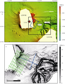
 ), 夏真1,2, 刘文涛1,2(