
热带海洋学报 ›› 2026, Vol. 45 ›› Issue (3): 10-24.doi: 10.11978/2025073CSTR: 32234.14.2025073
所属专题: 南海专题
南海U形海疆线的地质构造特征研究
张云帆1( ), 唐丹玲2(), 孙珍1(), 邱宁3
- 1
边缘海与大洋地质实验室(中国科学院南海海洋研究所)
2南方海洋科学与工程广东省实验室(广州)
3热带海洋环境与岛礁生态全国重点实验室(中国科学院南海海洋研究所
-
收稿日期:2025-06-04修回日期:2025-10-10出版日期:2026-05-10发布日期:2026-05-28 -
通讯作者:孙珍。email: sun_zhen2024@126.com; 唐丹玲。email: lingzistdl@126.com -
作者简介:张云帆(1983—), 女, 天津市人, 副研究员, 博士, 主要研究方向为海洋地质学。email: geozyf@163.com
-
基金资助:广东省特支计划创新团队项目(2019BT02H594); 南方海洋科学与工程广东省实验室(广州)引进高端领军人才队伍项目(GML2021GD0810)
Study on the geological structural characteristics of the U-shaped boundary in the South China Sea
ZHANG Yunfan1(), TANG Danling2(), SUN Zhen1(), QIU Ning3
- 1
Laboratory of Ocean and Marginal Sea Geology ,South China Sea Institute of Oceanology, Chinese Academy of Sciences
2Southern Marine Science and Engineering Guangdong Laboratory (Guangzhou)
3State Key Laboratory of Tropical Oceanography ,South China Sea Institute of Oceanology, Chinese Academy of Sciences
-
Received:2025-06-04Revised:2025-10-10Online:2026-05-10Published:2026-05-28 -
Contact:SUN Zhen. email: sun_zhen2024@126.com; TANG Danling. email: lingzistdl@126.com -
Supported by:Guangdong Special Support Talent Team Program(2019BT02H594); PI Project of Southern Marine Science and Engineering Guangdong Laboratory (Guangzhou)(GML2021GD0810)
摘要:
南海U形海疆线是我国在南海的权益边界, 是维护国家海洋权益和推进海洋强国战略的关键区域, 认识南海U形海疆线的下伏地质构造特征具有重要科学意义。本文深入分析南海U形海疆线海底地形、自由空间重力异常和磁力异常数据, 研究U形线西北、西、南、东和东北五个区间的地球物理与地质特征, 并探讨其与南海演化的关系。研究发现, 南海U形线(带)的海底地形为“西浅南平东深”, 水深在0~5400m之间; 自由空间重力异常整体与地形呈正相关, 异常分布范围为-100~0mGal, 磁力异常整体呈正异常(-50~100nT), 反映了海底以下岩石的磁性变化和空间赋存状态。研究还进一步揭示了U形海疆线走向与海底地貌构造单元的一致性: U形线西区段与红河断裂系统、南海西缘断裂走向一致, 其中西北段和西段在走滑伸展的背景下断面结构具有挤压褶皱和负花状构造; U形线南区段与南海南部陆架坡折和南沙海槽重合, 剖面构造在早—中中新世界面表现出大规模的破裂不整合特征, U形线东区段在平面上与马尼拉海沟走向一致, 在断面上处于南海板块俯冲于菲律宾海板块所产生的增生楔处; U形海疆线在南海西部陆缘、东南部陆缘、东部边界都处于重力异常剧烈变化的梯度带上, 代表了地形地貌的强烈起伏, 是构造的边界和天然的分界线。本研究成果总结了南海U形海疆线的数据基础和地质资料, 将为南海海洋划界和南海防灾减灾提供科学支撑。
中图分类号:
- P736
引用本文
张云帆, 唐丹玲, 孙珍, 邱宁. 南海U形海疆线的地质构造特征研究[J]. 热带海洋学报, 2026, 45(3): 10-24.
ZHANG Yunfan, TANG Danling, SUN Zhen, QIU Ning. Study on the geological structural characteristics of the U-shaped boundary in the South China Sea[J]. Journal of Tropical Oceanography, 2026, 45(3): 10-24.
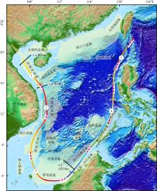
图1
南海U形线与南海区域构造地质图 该图基于自然资源部标准地图服务网站下载的审图号为 GS(2016)1613号的标准地图制作。图中彩色带为U形海疆线, 浅黄色为南海周缘盆地。序号为U形线5区间分法: 1为西北段、2为西区段、3为南区段、4为东区段、5为东北段。红色虚线为九段线根据南海地形分布图(罗伟东, 2023)绘制"

图1
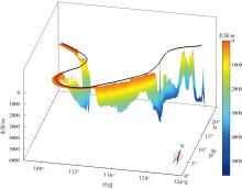
图2
南海U形线水深立体图"

图2
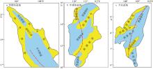
图3
南海U形线与莺歌海盆地、中建南盆地、万安盆地构造单元图 图中红色点划线为U形线, 蓝色区域为坳陷, 黄色区域为隆起。根据许璐(2018)、王伟平 等(2022)和肖鸿议 等(2021)修改"

图3
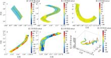
图4
南海U形海疆线分段重力异常平面图与立体图 a.西北段重力异常平面图; b. 西区段重力异常平面图; c. 南区段重力异常平面图; d. 东区段重力异常平面图; e. 东北段重力异常平面图; f. U形线重力异常立体图"

图4
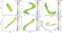
图5
南海U形海疆线分段线磁力异常平面图与立体图 a.西北段磁力异常平面图; b. 西区段磁力异常平面图; c. 南区段磁力异常平面图; d. 东区段磁力异常平面图; e. 东北段磁力异常平面图; f. U形线磁力异常立体图"
图5
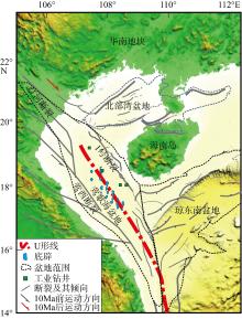
图6
南海U形线西北段构造特征平面图 红色点划线为U形线, 黑色线段为断裂, 蓝色点为底辟构造, 根据Lei等(2015)识别"
图6
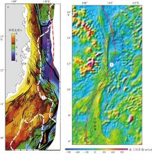
图7
南海U形线西区段构造特征与南海西缘断裂的断裂走向 a.断裂平面分布图; b. 自由空气重力异常图。根据Fyhn等(2009)修改, 数字2为U形线西区段"

图7
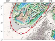
图8
南海U形线南区段、东区段与南海南部陆架坡折 灰色阴影为水深100~200m区域, 编号3为U形线南区段, 编号4为U形线东区段"
图8
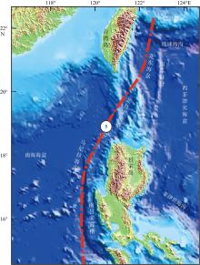
图9
U形线东北段和马尼拉海沟平面构造单元"

图9
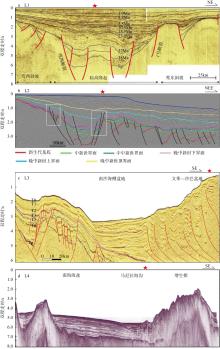
图10
横跨U形线的地震剖面 测线位置见图1, 红五角星代表U形线大致位置。L1为U形线西北段莺歌海盆地地震剖面解释图(Sun et al, 2003; Lei et al, 2015); L2为U形线西区段南海西缘断裂地震剖面构造图(Vu et al, 2017); L3为U形线东区段南沙地块地震剖面解释图(姚永坚, 2023); L4为U形线东北段马尼拉俯冲带地震剖面构造图(Chang et al, 2012)"

图10
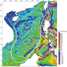
图11
南海区域自由空间重力异常特征 白色线为U形线; 该图基于自然资源部标准地图服务网站下载的审图号为 GS(2016)1613号的标准地图制作"

图11
| [1] |
龚再升, 李思田, 谢泰俊, 等, 1997. 南海北部大陆边缘盆地分析与油气聚集[M]. 北京: 科学出版社: 12-16.
|
|
|
|
| [2] |
郭令智, 钟志洪, 王良书, 等, 2001. 莺歌海盆地周边区域构造演化[J]. 高校地质学报, 7(1): 1-12.
|
|
|
|
| [3] |
高红芳, 2011. 南海西缘断裂带走滑特征及其形成机理初步研究[J]. 中国地质, 38(3): 537-543.
|
|
|
|
| [4] |
罗伟东, 胡小三, 周娇, 等, 2023. 南海及邻域海底地形地貌[M], 北京: 科学出版社: 12-16.
|
|
|
|
| [5] |
李春峰, 林间, 2014. 南海第二次国际大洋钻探获得完整深海岩芯记录[J]. 科学通报, 59(12): 1164 (in Chinese).
|
| [6] |
李家彪, 丁巍伟, 高金耀, 等, 2011. 南海新生代海底扩张的构造演化模式: 来自高分辨率地球物理数据的新认识[J]. 地球物理学报, 54(12): 3004-3015.
|
|
|
|
| [7] |
李敬敏, 张文志, 刘诗华, 等, 2022. 南海U形海疆线及南海诸岛部分地名数据集研究[J]. 全球变化数据学报(中英文), 6(1): 118-124.
|
|
|
|
| [8] |
林长松, 唐勇, 谭勇华, 2009. 南海西缘断裂带右行走滑的地球动力学机制[J]. 海洋学报, 31(1): 159-167.
|
|
|
|
| [9] |
刘宇鹏, 唐丹玲, 吴常霞, 等, 2019. 南海U形海疆线的生态环境分区特征[J]. 海洋学报, 41(2): 14-30.
|
|
|
|
| [10] |
骆遥, 李敬敏, 张文志, 等, 2019. 反映南海U形海疆线的《南洋群岛新地图》[J]. 科学通报, 64(23): 2390-2394.
|
|
|
|
| [11] |
任建业, 雷超, 2011. 莺歌海—琼东南盆地构造-地层格架及南海动力变形分区[J]. 地球物理学报, 54(12): 3303-3314.
|
|
|
|
| [12] |
孙珍, 钟志洪, 周蒂, 等, 2006. 南海的发育机制研究: 相似模拟证据[J]. 中国科学 D辑: 地球科学, 36(9): 797-810 (in Chinese).
|
| [13] |
孙珍, 赵中贤, 李家彪, 等, 2011. 南沙地块内破裂不整合与碰撞不整合的构造分析[J]. 地球物理学报, 54(12): 3196-3209.
|
|
|
|
| [14] |
孙珍, 2022. 南海的形成与演变[J]. 自然杂志, 44(1): 31-38.
|
|
doi: 10.3969/j.issn.0253-9608.2022.01.003 |
|
| [15] |
唐丹玲, 刘宇鹏, 郝晓光, 等, 2018. 国界线和行政区线表示南海U形海疆线的地图[J]. 科学通报, 63(9): 856-864.
|
|
|
|
| [16] |
唐丹玲, 刘旺, 隋广军, 等, 2021. 文献计量分析南海及其U形海疆线的遥感研究热点[J]. 热带海洋学报, 40(3): 83-95.
doi: 10.11978/YG2020004 |
|
doi: 10.11978/YG2020004 |
|
| [17] |
唐盟, 马劲松, 王颖, 等, 2016. 1947年中国南海断续线精准划定的地形依据[J]. 地理学报, 71(6): 914-927.
doi: 10.11821/dlxb201606002 |
|
doi: 10.11821/dlxb201606002 |
|
| [18] |
王伟平, 姚永坚, 蔡周荣, 等, 2022. 中建南盆地后扩张期T5和T3不整合面的发育特征及对南海科学钻探的意义[J]. 地质学报, 96(8): 2822-2832.
|
|
|
|
| [19] |
王颖, 葛晨东, 邹欣庆, 2014. 论证南海海疆国界线[J]. 海洋学报, 36(10): 1-11.
|
|
|
|
| [20] |
肖鸿议, 何云龙, 解习农, 等, 2021. 南海万安盆地构造-层序发育特征与构造-沉积充填演化[J]. 地球科学, 46(9): 3338-3351.
|
|
|
|
| [21] |
许璐, 2018. 莺歌海盆地东方X区黄流组Ⅰ段浅海海底扇精细表征及主控因素研究[D]. 西安: 西安石油大学.
|
|
|
|
| [22] |
姚永坚, 李学杰, 汪俊, 等, 2023. 南海及邻域构造地质[M]. 北京: 科学出版社.
|
|
|
|
| [23] |
张功成, 陈国俊, 张厚和, 等, 2012. “源热共控”中国近海盆地油气田“内油外气”有序分布[J]. 沉积学报, 30(1): 1-19.
|
|
|
|
| [24] |
赵明辉, 程锦辉, 高金尉, 等, 2021. 南海东部马尼拉俯冲带深部结构新认识[J]. 热带海洋学报, 40(3): 25-33.
doi: 10.11978/YG2020011 |
|
doi: 10.11978/YG2020011 |
|
| [25] |
钟志洪, 李绪宣, 孙珍, 等, 2007. 莺歌海盆地的构造反转作用及其油气勘探意义[J]. 热带海洋学报, 26(1): 16-21.
|
|
|
|
| [26] |
朱伟林, 钟锴, 李友川, 等, 2012. 南海北部深水区油气成藏与勘探[J]. 科学通报, 57(20): 1833-1841.
|
|
doi: 10.1007/s11434-012-4994-5 |
|
| [27] |
|
| [28] |
doi: 10.1007/s11001-013-9168-6 |
| [29] |
doi: 10.1016/j.epsl.2018.02.011 |
| [30] |
doi: 10.1016/j.tecto.2009.08.002 |
| [31] |
|
| [32] |
doi: 10.1016/j.tecto.2007.11.012 |
| [33] |
doi: 10.1016/j.tecto.2015.05.024 |
| [34] |
doi: 10.1007/s11001-013-9193-5 |
| [35] |
|
| [36] |
|
| [37] |
doi: 10.1111/rge.2007.57.issue-2 |
| [38] |
doi: 10.1126/science.1258213 |
| [39] |
doi: 10.1016/j.epsl.2005.01.018 |
| [40] |
doi: 10.1016/S0040-1951(03)00230-0 |
| [41] |
|
| [42] |
doi: 10.1093/nsr/nwz116 |
| [43] |
doi: 10.1007/s00343-023-3403-2 |
| [44] |
|
| [45] |
doi: 10.1016/j.marpetgeo.2017.06.001 |
| [46] |
doi: 10.1002/jgrb.v121.6 |
| [47] |
doi: 10.1029/1999GL900148 |
| [48] |
doi: 10.1046/j.1440-1738.2003.00382.x |
| [49] |
doi: 10.1016/0040-1951(95)00018-6 |
| [1] | 唐丹玲, 刘旺, 隋广军, 王颖, 王素芬. 文献计量分析南海及其U形海疆线的遥感研究热点[J]. 热带海洋学报, 2021, 40(3): 83-95. |
| [2] | 鲁宝亮, 王万银, 张功成, 王璞珺. 红河断裂带海域延伸位置的地球物理证据及其与南海扩张的关系*[J]. 热带海洋学报, 2015, 34(5): 64-74. |
|
||