
热带海洋学报 ›› 2021, Vol. 40 ›› Issue (3): 83-95.doi: 10.11978/YG2020004CSTR: 32234.14.YG2020004
文献计量分析南海及其U形海疆线的遥感研究热点
唐丹玲1,2,5( ), 刘旺1,2,5, 隋广军3, 王颖4, 王素芬1,2,5
- 1.中国科学院南海海海洋研究所, 热带海洋环境国家重点实验室, 广东省海洋遥感重点实验室, 广东 广州 511458
2.南方海洋科学与工程广东省实验室(广州), 广东 广州 511458
3.广东外语外贸大学广东国际战略研究院, 广东 广州 510420
4.南京大学地理与海洋科学学院, 江苏 南京 210023
5.中国科学院大学, 北京 100049
-
收稿日期:2020-08-24修回日期:2020-12-04出版日期:2021-05-10发布日期:2020-12-12 -
通讯作者:唐丹玲 -
作者简介:唐丹玲(1959—), 女, 湖北省武汉市人, 教授, 博士, 主要从事海洋生态与环境遥感研究。email:lingzistdl@126.com -
基金资助:国家自然科学基金项目(41876136);国家自然科学重点项目(41430968);广东省特支计划创新团队项目(2019BT02H594);广东省自然科学基金平台项目(2017B030301005);南方海洋科学与工程广东省实验室(广州)人才团队引进重大专项(GML2019ZD0602);中国科学院知识创新工程项目(ISEE2019ZR02);国家科技基础资源调查专项资助(2018FY100100)
A bibliometric analysis of remote sensing research hotspots on the South China Sea and its U-boundary
TANG Danling1,2,5(), LIU Wang1,2,5, SUI Guangjun3, WANG Ying4, WANG Sufen1,2,5
- 1. Guangdong Key Laboratory of Ocean Remote Sensing (LORS), State Key Laboratory of Tropical Oceanography, South China Sea Institute of Oceanology, Chinese Academy of Sciences, Guangzhou 511458, China
2. Southern Marine Science and Engineering Guangdong Laboratory (Guangzhou), Guangzhou 511458, China
3. Guangdong Institute for International Strategies, Guangdong University of Foreign Studies, Guangzhou 510420, China
4. School of Geographic and Oceanographic Sciences, Nanjing University, Nanjing 210023, China
5. University of Chinese Academy of Sciences, Beijing 100049, China
-
Received:2020-08-24Revised:2020-12-04Online:2021-05-10Published:2020-12-12 -
Contact:TANG Danling -
Supported by:National Natural Science Foundation of China(41876136);National Natural Science Key Project(41430968);Guangdong Key Program(2019BT02H594);Natural Science Foundation of Guangdong Province(2017B030301005);Key Special Project for Introduced Talents Team of Southern Marine Science and Engineering Guangdong Laboratory (Guangzhou)(GML2019ZD0602);Knowledge Innovation Program of the Chinese Academy of Sciences(ISEE2019ZR02);National Science & Technology Fundamental Resources Investigation Program of China(2018FY100100)
摘要:
为综合评估遥感技术在南海、尤其在南海U形海疆国界线(简称南海U形海疆线)研究中的应用情况, 本文以中国知识基础设施工程(China National Knowledge Infrastructure, CNKI)和Web of Science核心合集 (Web of Science Core Collection, WOSCC)分别作为中文与外文期刊论文数据库来源, 筛选出截至2019年已发表的相关主题的中外期刊文献, 进行文献计量分析。按照关键词筛选的三类论文为: 南海自然科学研究(中文10150篇, 外文10130篇), 南海遥感研究(中文560篇, 外文1296篇)与南海U形海疆线相关研究(中文303篇, 外文33篇)。文献计量分析表明: 南海自然科学研究总发文量最大的国家为中国(18253篇), 总发文量排名前列的研究机构(如排名第一的中国科学院南海海洋研究所)与期刊(如排名第一的《热带海洋学报》)也主要来自中国; 年发文量变化趋势显示, 南海自然科学研究呈现四个阶段(缓慢起步、缓慢增长、快速增长和回降), 南海遥感研究有两个阶段(缓慢起步与快速增长), 南海U形海疆线研究中文论文呈现三个阶段(缓慢起步、快速增长与回降); 热点研究显示, 南海自然科学研究围绕季风、天然气水合物与台风开展, 南海遥感研究关注海表温度、叶绿素与台风, 南海U形海疆线研究关注南海争端和地质特征。遥感数据于1974年开始被用于南海台风研究, 2019年被用于南海U形海疆线的生态环境研究。发展海洋遥感技术, 深化南海台风“风泵”生态效应与灾害研究, 拓展南海U形海疆线走廊立体的综合科学研究和增强南海的自然科学与社会科学的交叉研究, 意义重大。
中图分类号:
- G353.1
引用本文
唐丹玲, 刘旺, 隋广军, 王颖, 王素芬. 文献计量分析南海及其U形海疆线的遥感研究热点[J]. 热带海洋学报, 2021, 40(3): 83-95.
TANG Danling, LIU Wang, SUI Guangjun, WANG Ying, WANG Sufen. A bibliometric analysis of remote sensing research hotspots on the South China Sea and its U-boundary[J]. Journal of Tropical Oceanography, 2021, 40(3): 83-95.
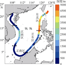
图1
南海U形海疆线5区间的水深特性图 填色表示水深1~5000m, 黑虚线表示南海U形海疆线5区间位置。修改引用自刘宇鹏等(2019)"

图1
表1
南海各分类研究期刊论文的基本信息(分类名称的括号内容分别代表来源数据库为CNKI与WOSCC)"
| 分类名称 | 检索依据 | 文献总量 | 发表时间 |
|---|---|---|---|
| 南海自然科学(CNKI) | 检索词: 南海; 文献分类: 基础科学、工程科技、农业科技、医药卫生科技与信息科技; 语言: 中文 | 10150篇 | 1935—2019 |
| 南海自然科学(WOSCC) | 检索词: South China Sea; 文献类型: Article、Review; 类别: Geosciences、Oceanography等自然科学领域; 语言: 非中文 | 10130篇(英语10067篇、俄语36篇、法语10篇、日语7篇、德语5篇、马来西亚语4篇与西班牙语1篇) | 1921—2019 |
| 南海遥感(CNKI) | 检索词: “南海”和“遥感”、“南海”“和“卫星”; 语言: 中文 | 560篇 | 1974—2019 |
| 南海遥感(WOSCC) | 检索词: “South China Sea” and “Remote Sensing”、“South China Sea” and “Satellite”; 文献类型: Article、Review; 语言: 非中文 | 1296篇(英语1295篇、 法语1篇) | 1977—2019 |
| 南海U形海疆线(CNKI) | 检索词: 南海U形海疆线、U形线、九段线、断续线、十一段线; 语言: 中文 | 303篇 | 1983—2019 |
| 南海U形海疆线(WOSCC) | 检索词: “the U-boundary line”、“U-shaped line”、“nine-dotted line”、“nine-dash line” and “South China Sea”; 文献类型: Article、Review; 语言: 非中文 | 33篇(英语33篇) | 2006—2019 |
表1
图2
CNKI和WOSCC中南海研究期刊论文的年发文量 a. 发表于1921—2019年的6种研究分类的期刊论文; b. 发表于1921—1974年的南海自然科学研究的期刊论文; c. 发表于1974—2019年的4种研究分类的期刊论文"
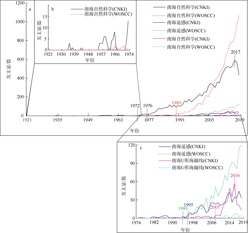
图2

图3
研究南海的主要机构 a. CNKI中南海自然科学研究总发文量排名前10的机构; b. WOSCC中南海自然科学研究总发文量排名前10的机构; c. CNKI中南海遥感研究总发文量排名前5的机构; d. WOSCC中南海遥感研究总发文量排名前5的机构; e. CNKI中南海U形海疆线研究总发文量排名前5的机构。国家海洋局第一、第二海洋研究所现为自然资源部第一、第二海洋研究所"
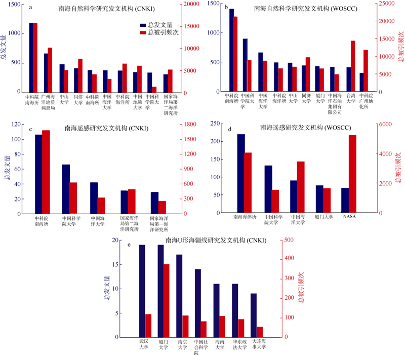
图3
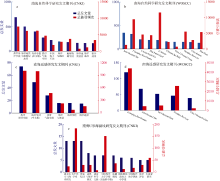
图4
研究南海的主要期刊 a. CNKI中南海自然科学研究总发文量排名前10的期刊; b. WOSCC中南海自然科学研究总发文量排名前10的期刊; c. CNKI中南海遥感研究总发文量排名前5的期刊; d. WOSCC中南海研究总发文量排名前5的期刊; e. CNKI中南海U形海疆线研究总发文量排名前10的期刊"

图4
表2
WOSCC中南海U形海疆线研究的发文期刊的基本信息(2006—2019)"
| 期刊名 | 出版国 | 发文量 | 发文机构所在地 |
|---|---|---|---|
| OCEAN DEVELOPMENT AND INTERNATIONAL LAW | 英国 | 7篇 | 中国台湾(3篇)、英国(2篇)、菲律宾(1篇), 越南与英国合作1篇 |
| AUSTRALIAN JOURNAL OF INTERNATIONAL AFFAIRS(《澳大利亚国际事务杂志》) | 英国 | 1篇 | 英国 |
| CHINA INFORMATION(《中国信息》) | 英国 | 1篇 | 澳大利亚 |
| PACIFIC REVIEW(《太平洋评论》) | 英国 | 1篇 | 中国 |
| JOURNAL OF EAST ASIA AND INTERNATIONAL LAW | 韩国 | 6篇 | 澳大利亚(2篇)、印度尼西亚(1篇)、中国台湾(1篇)、瑞士(1)与芬兰(1篇) |
| INHA LAW REVIEW(《韩国仁荷法律评论》) | 韩国 | 1篇 | 韩国 |
| KOREA INTERNATIONAL LAW REVIEW(《韩国国际法评论》) | 韩国 | 1篇 | 韩国 |
| MARITIME LAW REVIEW(《海事法律评论》) | 韩国 | 1篇 | 韩国 |
| OCEAN POLICY RESEARCH(《海洋政策调查》) | 韩国 | 1篇 | 韩国 |
| ASIAN SURVEY(《亚洲调查》) | 美国 | 2篇 | 美国 |
| MODERN CHINA(《现代中国》) | 美国 | 2篇 | 英国(1篇)、加拿大(1篇) |
| AMERICAN JOURNAL OF INTERNATIONAL LAW(《美国国际法杂志》) | 美国 | 1篇 | 中国台湾 |
| PACIFIC FOCUS(《太平洋焦点》) | 美国 | 1篇 | 韩国 |
| CORNELL INTERNATIONAL LAW JOURNAL(《康奈尔国际法期刊》) | 美国 | 1篇 | 美国 |
| INTERNATIONAL JOURNAL OF MARINE AND COASTAL LAW | 荷兰 | 3篇 | 英国(1篇)、丹麦(1篇), 澳大利亚与中国合作1篇 |
| ACTA OCEANOLOGICA SINICA | 中国 | 1篇 | 中国 |
| CHINA REVIEW-AN INTERDISCIPLINARY JOURNAL ON GREATER CHINA(《中国大中华跨学科期刊综述》) | 中国 | 1篇 | 日本 |
| REVISTA CHILENA DE DERECHO(《智利法律杂志》) | 智利 | 1篇 | 智利 |
表2
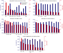
图5
南海研究的出现频次排名前10的关键词 a. CNKI中的南海自然科学研究; b. WOSCC中的南海自然科学研究; c. CNKI中的南海遥感研究; d. WOSCC中的南海遥感研究; e. CNKI中的南海U形海疆线研究"
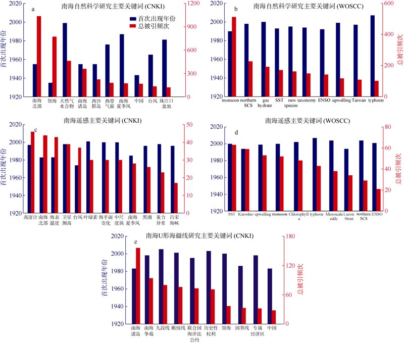
图5
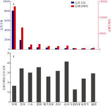
图6
WOSCC中南海自然科学研究总发文量排名前10的国家 a. 总发文量与总被引频次; b. 总被引频次与总发文量的比值。由于未从WOSCC中筛选由中国澳门发表的南海相关期刊论文, 所以此处仅包含中国大陆、中国香港和中国台湾的发文量。横坐标序号代表总发文量排名"

图6
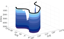
图7
南海U形海疆线走廊水下部分示意图"
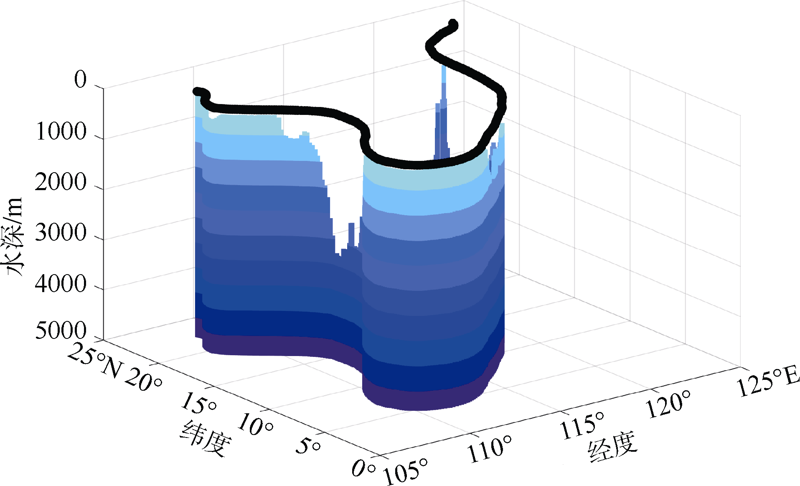
图7
| [1] | 陈奇礼, 1993. 对南海季风进退及强度的气候分析[J]. 热带气象学报, 9(2):124-132. |
| CHEN QILI, 1993. A climatological analysis of advancing/retreating movement of South China Sea monsoon and its intensity[J]. Journal of Tropical Meteorology, 9(2):124-132 (in Chinese with English abstract). | |
| [2] | 傅崐成, 崔浩然, 2019. 南海U形线的法律性质与历史性权利的内涵[J]. 厦门大学学报(哲学社会科学版), (4):66-75. |
| FU KUNCHENG, CUI HAORAN, 2019. The U-shaped line’s legal nature and historic rights of the South China Sea[J]. Journal of Xiamen University (Arts & Social Sciences), (4):66-75 (in Chinese with English abstract). | |
| [3] | 公衍芬, 杨文斌, 谭树东, 2012. 南海油气资源综述及开发战略设想[J]. 海洋地质与第四纪地质, 32(5):137-147. |
| GONG YANFEN, YANG WENBIN, TAN SHUDONG, 2012. Oil and gas resources in the South China Sea and its development strategy: a review[J]. Marine Geology & Quaternary Geology, 32(5):137-147 (in Chinese with English abstract). | |
| [4] | 林明森, 张有广, 袁欣哲, 2015. 海洋遥感卫星发展历程与趋势展望[J]. 海洋学报, 37(1):1-10. |
| LIN MINGSEN, ZHANG YOUGUANG, YUAN XINZHE, 2015. The development course and trend of ocean remote sensing satellite[J]. Acta Oceanologica Sinica, 37(1):1-10 (in Chinese with English abstract). | |
| [5] | 刘畅, 白强, 唐高, 等, 2018. 中国海洋遥感技术进展[J]. 船舶与海洋工程, 34(1):1-6. |
| LIU CHANG, BAI QIANG, TANG GAO, et al, 2018. Development of marine remote sensing technology in China[J]. Naval Architecture and Ocean Engineering, 34(1):1-6 (in Chinese with English abstract). | |
| [6] | 刘宇鹏, 唐丹玲, 吴常霞, 等, 2019. 南海U形海疆线的生态环境分区特征[J]. 海洋学报, 41(2):14-30. |
| LIU YUPENG, TANG DANLING, WU CHANGXIA, et al, 2019. Zoning of the U-boundary in the South China Sea and its ecological environment characteristics[J]. Acta Oceanologica Sinica, 41(2):14-30 (in Chinese with English abstract). | |
| [7] | 骆遥, 李敬敏, 张文志, 等, 2019. 反映南海U形海疆线的《南洋群岛新地图》[J]. 科学通报, 64(23):2390-2394. |
| LUO YAO, LI JINGMIN, ZHANG WENZHI, et al, 2019. A historical Map of East Indies representing the U-boundary in the South China Sea as an international boundary[J]. Chinese Science Bulletin, 64(23):2390-2394 (in Chinese with English abstract). | |
| [8] | 邵磊, 庞雄, 乔培军, 等, 2008. 珠江口盆地的沉积充填与珠江的形成演变[J]. 沉积学报, 26(2):179-185. |
| SHAO LEI, PANG XIONG, QIAO PEIJUN, et al, 2008. Sedimentary filling of the Pearl River Mouth Basin and its response to the evolution of the Pearl River[J]. Acta Sedimentologica Sinica, 26(2):179-185 (in Chinese with English abstract). | |
| [9] | 邵劲超, 2015. 热带气旋移动速度和强度对南海北部叶绿素浓度的影响[D]. 湛江:广东海洋大学. |
| SHAO JINCHAO, 2015. The impact of tropical cyclone translation speed and intensity on phytoplankton chlorophyll-a concentration in the northern South China Sea[D]. Zhanjiang: Guangdong Ocean University (in Chinese with English abstract). | |
| [10] | 邵勰, 黄平, 黄荣辉, 2014. 南海夏季风爆发的研究进展[J]. 地球科学进展, 29(10):1126-1137. |
| SHAO XIE, HUANG PING, HUANG RONGHUI, 2014. A review of the South China Sea summer monsoon onset[J]. Advances in Earth Science, 29(10):1126-1137 (in Chinese with English abstract). | |
| [11] | 隋广军, 唐丹玲, 2015. 台风灾害评估与应急管理[M]. 北京: 科学出版社: 10-26. |
| SUI GUANGJUN, TANG DANLING, 2015. Typhoon disaster assessment and emergency management[M]. Beijing: Science Press: 10-26(in Chinese). | |
| [12] | 孙庆杨, 林静柔, 唐丹玲, 等, 2020. 南海海气CO2交换对两个热带气旋“风泵”的不同响应机理分析[J]. 生态科学, 39(3):9-16. |
| SUN QINGYANG, LIN JINGROU, TANG DANLING, et al, 2020. Different mechanisms of air-sea CO2 exchange responding to “Wind Pump” effects of two tropical cyclones in South China Sea[J]. Ecological Science, 39(3):9-16 (in Chinese with English abstract). | |
| [13] | 孙智超, 2016. 基于词频分析的十余年国内南海研究热点探析[J]. 晋图学刊, (5):57-63. |
| SUN ZHICHAO, 2016. The analysis based on word frequency for over 10 years of domestic South China Sea study hotspot[J]. Shanxi Library Journal, (5):57-63 (in Chinese with English abstract). | |
| [14] | 唐丹玲, 刘宇鹏, 郝晓光, 等, 2018. 国界线和行政区线表示南海U形海疆线的地图[J]. 科学通报, 63(9):856-864. |
| TANG DANLING, LIU YUPENG, HAO XIAOGUANG, et al, 2018. A newly-discovered historical map using both national boundary and administrative line to represent the U-boundary in the South China Sea[J]. Chinese Science Bulletin, 63(9):856-864 (in Chinese with English abstract). | |
| [15] |
唐盟, 马劲松, 王颖, 等, 2016. 1947年中国南海断续线精准划定的地形依据[J]. 地理学报, 71(6):914-927.
doi: 10.11821/dlxb201606002 |
|
TANG MENG, MA JINSONG, WANG YING, et al, 2016. Spatial demarcation principles of the Dotted Line in the South China Sea[J]. Acta Geographica Sinica, 71(6):914-927 (in Chinese with English abstract).
doi: 10.11821/dlxb201606002 |
|
| [16] | 唐苗苗, 李晓峰, 2019. 海洋遥感技术资料的计量分析[J]. 河北渔业, (6):54-57. |
| TANG MIAOMIAO, LI XIAOFENG, 2019. Metrological analysis on papers about ocean remote sensing[J]. Hebei Fisheries, (6):54-57 (in Chinese with English abstract). | |
| [17] | 唐晓音, 杨树春, 张功成, 等, 2013. 南海地热研究综述[J]. 地球物理学进展, 28(2):988-997. |
| TANG XIAOYIN, YANG SHUCHUN, ZHANG GONGCHENG, et al, 2013. Overview on geothermal investigation of the South China Sea[J]. Progress in Geophysics, 28(2):988-997 (in Chinese with English abstract). | |
| [18] | 王颖, 马劲松, 2003. 南海海底特征、资源区位与疆界断续线[J]. 南京大学学报(自然科学版), 39(6):797-805. |
| WANG YING, MA JINSONG, 2003. Characteristics of submarine geomorphology, natural resources distribution and border intermittent lines of the South China Sea[J]. Journal of Nanjing University (Natural Science), 39(6):797-805 (in Chinese with English abstract). | |
| [19] | 王颖, 葛晨东, 邹欣庆, 2014. 论证南海海疆国界线[J]. 海洋学报, 36(10):1-11. |
| WANG YING, GE CHENDONG, ZOU XINQING, 2014. Evidence of China's maritime boundary in the South China Sea[J]. Acta Oceanologica Sinica, 36(10):1-11 (in Chinese with English abstract). | |
| [20] | 许夙晖, 慕晓冬, 柯冰, 等, 2014. 基于遥感影像的军事阵地动态监测技术研究[J]. 遥感技术与应用, 29(3):511-516. |
| XU SUHUI, MU XIAODONG, KE BING, et al, 2014. Dynamic monitoring of military position based on remote sensing image[J]. Remote Sensing Technology and Application, 29(3):511-516 (in Chinese with English abstract). | |
| [21] | 杨东平, 2006. 从权利平等到机会均等——新中国教育公平的轨迹[J]. 北京大学教育评论, 4(2):2-11. |
| YANG DONGPING, 2006. From equality of right to equality of opportunity: the slot of educational equity in new China[J]. Peking University Education Review, 4(2):2-11 (in Chinese with English abstract). | |
| [22] | 杨照德, 2005. 卫星上天蕴涵的文化意义——纪念我国第一颗人造卫星上天35周年[J]. 国防科技工业, (4):28-29. |
| [23] | 游长江, 侯佩旭, 邓灿芳, 等, 2015. 西沙群岛海岛旅游资源综合评价[J]. 热带地理, 35(6):926-933. |
| YOU CHANGJIANG, HOU PEIXU, DENG CANFANG, et al, 2015. Comprehensive evaluation on tourism resources in the Xisha Islands[J]. Tropical Geography, 35(6):926-933 (in Chinese with English abstract). | |
| [24] | 张功成, 贾庆军, 王万银, 等, 2018. 南海构造格局及其演化[J]. 地球物理学报, 61(10):4194-4215. |
| ZHANG GONGCHENG, JIA QINGJUN, WANG WANYIN, et al, 2018. On tectonic framework and evolution of the South China Sea[J]. Chinese Journal of Geophysics, 61(10):4194-4215 (in Chinese with English abstract). | |
| [25] | 张洪涛, 张海启, 祝有海, 2007. 中国天然气水合物调查研究现状及其进展[J]. 中国地质, 34(6):953-961. |
| ZHANG HONGTAO, ZHANG HAIQI, ZHU YOUHAI, 2007. Gas hydrate investigation and research in China: present status and progress[J]. Geology in China, 34(6):953-961 (in Chinese with English abstract). | |
| [26] |
张君珏, 苏奋振, 王雯玥, 2018. 南海资源环境地理研究综述[J]. 地理科学进展, 37(11):1443-1453.
doi: 10.18306/dlkxjz.2018.11.001 |
|
ZHANG JUNJUE, SU FENZHEN, WANG WENYUE. A review of geographical information research on resources and environment of the South China Sea region[J]. Progress in Geography, 37(11):1443-1453 (in Chinese with English abstract).
doi: 10.18306/dlkxjz.2018.11.001 |
|
| [27] | 赵斌, 刘胜旋, 李丽青, 等, 2018. 南海冷泉分布特征及油气地质意义[J]. 海洋地质前沿, 34(10):32-43. |
| ZHAO BIN, LIU SHENGXUAN, LI LIQING, et al, 2018. Distribution pattern of cold seeps in South China Sea and its geological significance[J]. Marine Geology Frontiers, 34(10):32-43 (in Chinese with English abstract). | |
| [28] | 周磊, 陈大可, 雷小途, 等, 2018. 海洋与台风相互作用研究进展[J]. 科学通报, 64(1):60-72. |
| ZHOU LEI, CHEN DAKE, LEI XIAOTU, et al, 2018. Progress and perspective on interactions between ocean and typhoon[J]. Chinese Science Bulletin, 64(1):60-72 (in Chinese with English abstract). | |
| [29] | 朱照宇, 邱燕, 周厚云, 等, 2002. 南海全球变化研究进展[J]. 地质力学学报, 8(4): 315-322+314. |
| ZHU ZHAOYU, QIU YAN, ZHOU HOUYUN, et al, 2002. A summary review of research progress on global change in the South China Sea[J]. Journal of Geomechanics, 8(4): 315-322+314. (in Chinese with English abstract). | |
| [30] | CLARK A, LI CHANG, 1993. Marine mineral resources of the South China sea[J]. Marine Georesources & Geotechnology, 11(1):101-126. |
| [31] |
CLARK C D, 1993. Satellite remote sensing for marine pollution investigations[J]. Marine Pollution Bulletin, 26(7):357-368.
doi: 10.1016/0025-326X(93)90182-J |
| [32] |
HUANG XIAODONG, CHEN ZHAOHUI, ZHAO WEI, et al, 2016. An extreme internal solitary wave event observed in the northern South China Sea[J]. Scientific Reports, 6:30041.
doi: 10.1038/srep30041 |
| [33] | KATSAROS B K, MITNIK L, BLACK P, 2014. Microwave instruments for observing tropical cyclones[M]// TANG DANLING, SUI GUANGJUN. Typhoon impact and crisis management. Berlin: Springer: 5-61. |
| [34] |
LIU QINYU, KANEKO A, SU JILAN, 2008. Recent progress in studies of the South China Sea circulation[J]. Journal of Oceanography, 64(5):753-762.
doi: 10.1007/s10872-008-0063-8 |
| [35] |
LIU YUPENG, TANG DANLING, EVGENY M, 2019. Chlorophyll concentration response to the typhoon wind-pump induced upper ocean processes considering air-sea heat exchange[J]. Remote Sensing, 11(15):1825.
doi: 10.3390/rs11151825 |
| [36] |
LIU YUPENG, TANG DANLING, TANG SHILIN, et al, 2020. A case study of Chlorophyll a response to tropical cyclone Wind Pump considering Kuroshio invasion and air-sea heat exchange[J]. Science of the Total Environment, 741:140290.
doi: 10.1016/j.scitotenv.2020.140290 |
| [37] |
PHILLIPS O M, 1988. Remote sensing of the sea surface[J]. Annual Review of Fluid Mechanics, 20:89-109.
doi: 10.1146/annurev.fl.20.010188.000513 |
| [38] |
SANTOS A M P, 2000. Fisheries oceanography using satellite and airborne remote sensing methods: a review[J]. Fisheries Research, 49(1):1-20.
doi: 10.1016/S0165-7836(00)00201-0 |
| [39] | TANG DANLING, 2011. Remote sensing of the changing oceans[M]. Berlin: Springer: 1-7. |
| [40] |
TANG DANLING, KAWAMURA H, LUIS A J, 2002a. Short-term variability of phytoplankton blooms associated with a cold eddy in the northwestern Arabian Sea[J]. Remote Sensing of Environment, 81(1):82-89.
doi: 10.1016/S0034-4257(01)00334-0 |
| [41] |
TANG DANLING, KESTER D R, NI I H, et al, 2002b. Upwelling in the Taiwan Strait during the summer monsoon detected by satellite and shipboard measurements[J]. Remote Sensing of Environment, 83(3):457-471.
doi: 10.1016/S0034-4257(02)00062-7 |
| [42] |
TANG DANLING, KESTER D R, WANG ZHAODING, et al, 2003. AVHRR satellite remote sensing and shipboard measurements of the thermal plume from the Daya Bay, nuclear power station, China[J]. Remote Sensing of Environment, 84(4):506-515.
doi: 10.1016/S0034-4257(02)00149-9 |
| [43] | TANG DANLING, NI I H, 1996. Remote sensing of Hong Kong waters: spatial and temporal changes of sea surface temperature[J]. Acta Oceanographica Taiwanica, 35:173-186. |
| [44] |
TANG DANLING, NI I H, KESTER D R, et al, 1999. Remote sensing observations of winter phytoplankton blooms southwest of the Luzon Strait in the South China Sea[J]. Marine Ecology Progress Series, 191:43-51.
doi: 10.3354/meps191043 |
| [45] |
TANG DANLING, NI I H, MÜLLER-KARGER F E, et al, 1998. Analysis of annual and spatial patterns of CZCS-derived pigment concentration on the continental shelf of China[J]. Continental Shelf Research, 18(12):1493-1515.
doi: 10.1016/S0278-4343(98)00039-9 |
| [46] | TANG DANLING, SUI GUANGJUN, 2014. Typhoon impact and crisis management[M]. Berlin: Springer: 1-4. |
| [47] | WANG YING, GE CHENDONG, ZOU XINQING, 2017. Evidence of China’s sea boundary in the South China Sea[J]. Acta Oceanologica Sinica, 36(4):1-12. |
| [48] |
XU HUABING, TANG DANLING, LIU YUPENG, et al, 2019a. Dissolved oxygen responses to tropical cyclones "Wind Pump" on pre-existing cyclonic and anticyclonic eddies in the Bay of Bengal[J]. Marine Pollution Bulletin, 146:838-847.
doi: 10.1016/j.marpolbul.2019.07.019 |
| [49] |
XU HUABING, TANG DANLING, SHENG JINYU, et al, 2019b. Study of dissolved oxygen responses to tropical cyclones in the Bay of Bengal based on Argo and satellite observations[J]. Science of the Total Environment, 659:912-922.
doi: 10.1016/j.scitotenv.2018.12.384 |
| [50] |
YANG JUN, GONG PENG, FU RONG, et al, 2013. Erratum: the role of satellite remote sensing in climate change studies[J]. Nature Climate Change, 3(11):1001.
doi: 10.1038/nclimate2033 |
| [51] |
YE HAIJUN, SHENG JINYU, TANG DANLING, et al, 2019. Examining the impact of tropical cyclones on air-sea CO2 exchanges in the Bay of Bengal based on satellite data and in situ observations[J]. Journal of Geophysical Research: Oceans, 124(1):555-576.
doi: 10.1029/2018JC014533 |
| [52] |
YU JIE, TANG DANLING, CHEN GUOBAO, et al, 2014. The positive effects of typhoons on the fish CPUE in the South China Sea[J]. Continental Shelf Research, 84:1-12.
doi: 10.1016/j.csr.2014.04.025 |
| [53] |
YU JIE, TANG DANLING, LI YONGZHEN, et al, 2013. Increase in fish abundance during two typhoons in the South China Sea[J]. Advances in Space Research, 51(9):1734-1749.
doi: 10.1016/j.asr.2012.11.019 |
| [54] |
ZHENG GUANGMING, TANG DANLING, 2007. Offshore and nearshore chlorophyll increases induced by typhoon winds and subsequent terrestrial rainwater runoff[J]. Marine Ecology Progress Series, 333:61-74.
doi: 10.3354/meps333061 |
| [55] |
ZHENG YI, YUE JUN, SUN XIAOFENG, et al, 2012. Studies of filtering effect on internal solitary wave flow field data in the South China Sea using EMD[J]. Advanced Materials Research, 518-523:1422-1425.
doi: 10.4028/www.scientific.net/AMR.518-523 |
| [56] |
ZHU YAOHUA, SUN JUNCHUAN, WANG YONGGANG, et al, 2019. Overview of the multi-layer circulation in the South China Sea[J]. Progress in Oceanography, 175:171-182.
doi: 10.1016/j.pocean.2019.04.001 |
| [1] | 徐超, 龙丽娟, 李莎, 袁丽, 徐晓璐. 南海及其附属岛礁海洋科学考察历史资料系统整编3. 数据共享服务及应用[J]. 热带海洋学报, 2024, 43(5): 158-165. |
| [2] | 徐超, 龙丽娟, 李莎, 何云开, 袁丽, 徐晓璐. 南海及其附属岛礁海洋科学考察历史资料系统整编1. 资料整编技术及应用[J]. 热带海洋学报, 2024, 43(5): 143-149. |
| [3] | 徐超, 龙丽娟, 李莎, 徐晓璐, 袁丽. 南海及其附属岛礁海洋科学考察历史资料系统整编2. 数据治理技术与应用[J]. 热带海洋学报, 2024, 43(5): 150-157. |
| [4] | 柳原, 柯志新, 李开枝, 谭烨辉, 梁竣策, 周伟华. 人类活动和沿岸流影响下的粤东近海浮游动物群落特征[J]. 热带海洋学报, 2024, 43(4): 98-111. |
| [5] | 刘玓玓, 张喜洋, 孙富林, 王明壮, 谭飞, 施祺, 王冠, 杨红强. 南海海滩岩微生物群落结构和特定菌株对其成因机制的启示*[J]. 热带海洋学报, 2024, 43(4): 112-122. |
| [6] | 江绿苗, 陈天然, 赵宽, 张婷, 许莉佳. 南海北部涠洲岛边缘珊瑚礁的生物侵蚀实验研究[J]. 热带海洋学报, 2024, 43(3): 155-165. |
| [7] | 许莉佳, 廖芝衡, 陈辉, 王永智, 黄柏强, 林巧云, 甘健锋, 杨静. 南海北部珊瑚群落结构特征及其对海洋热浪事件的响应[J]. 热带海洋学报, 2024, 43(3): 58-71. |
| [8] | 邱燕, 鞠东, 黄文凯, 王英民, 聂鑫. 南海中央海盆海底初始扩张时间的重新认定[J]. 热带海洋学报, 2024, 43(2): 154-165. |
| [9] | 赵明辉, 袁野, 张佳政, 张翠梅, 高金尉, 王强, 孙珍, 程锦辉. 南海北部被动陆缘洋陆转换带张裂-破裂研究新进展[J]. 热带海洋学报, 2024, 43(2): 173-183. |
| [10] | 黄谕, 王琳, 麦志茂, 李洁, 张偲. 南海热带岛礁生物土壤结皮中细菌的分离及其固砂特性初步研究[J]. 热带海洋学报, 2023, 42(6): 101-110. |
| [11] | 王辰燕, 史敬文, 颜安南, 康亚茹, 王煜轩, 覃素丽, 韩民伟, 张瑞杰, 余克服. 有机磷酸酯在南海长棘海星中的生物富集特征及来源解析[J]. 热带海洋学报, 2023, 42(5): 30-37. |
| [12] | 李牛, 邸鹏飞, 冯东, 陈多福. 冷泉渗漏对海洋沉积物氧化还原环境地球化学识别的影响——以南海东北部F站位活动冷泉为例*[J]. 热带海洋学报, 2023, 42(5): 144-153. |
| [13] | 张智晟, 谢玲玲, 李君益, 李强. 边缘海与开阔海中尺度涡生命周期演化规律对比分析: 以南海和黑潮延伸体为例[J]. 热带海洋学报, 2023, 42(4): 63-76. |
| [14] | 杨磊, 温金辉, 王强, 罗希, 黄华明, 何云开, 陈举. 热带气旋影响吕宋海峡输运的研究进展与展望*[J]. 热带海洋学报, 2023, 42(3): 40-51. |
| [15] | 赵中贤, 孙珍, 毛云华, 张伙带. 南海北部陆缘不均匀伸展及脉动式构造升降史*[J]. 热带海洋学报, 2023, 42(3): 96-115. |
|
||