
热带海洋学报 ›› 2022, Vol. 41 ›› Issue (4): 82-96.doi: 10.11978/2021091CSTR: 32234.14.2021091
台风季节朱家尖岛砂、砾质岬湾海滩的不同沉积地貌动态变化
郭俊丽1( ), 时连强2, 陈沈良1(), 张敏2, 常洋1, 张达恒2
- 1.华东师范大学 河口海岸学国家重点实验室, 上海 200241
2.自然资源部第二海洋研究所, 浙江 杭州 310012
-
收稿日期:2021-07-15修回日期:2021-09-07出版日期:2022-07-10发布日期:2021-09-19 -
通讯作者:陈沈良 -
作者简介:郭俊丽(1994—), 女, 河南开封人, 博士研究生, 主要从事海岸动力地貌过程研究。email:jlguo0826@163.com -
基金资助:浙江省基础公益研究计划项目(LHZ22D060001)
Dynamic variations of different sedimentary geomorphology of sandy and gravel embayed beaches on the Zhujiajian Island during typhoon season
GUO Junli1(), SHI Lianqiang2, CHEN Shenliang1(), ZHANG Min2, CHANG Yang1, ZHANG Daheng2
- 1. State Key Laboratory of Estuarine and Coastal Research, East China Normal University, Shanghai 200241, China
2. Second Institute of Oceanography, Ministry of Natural Resources, Hangzhou 310012, China
-
Received:2021-07-15Revised:2021-09-07Online:2022-07-10Published:2021-09-19 -
Contact:CHEN Shenliang -
Supported by:Zhejiang Provincial Natural Science Foundation of China(LHZ22D060001)
摘要:
岬湾砂、砾质海岸是海岛、海岸带重要的旅游资源, 具有较高的社会经济和生态价值, 长期以来备受关注。本文以浙江朱家尖岛东岸的5个代表性岬湾海滩为例, 基于2019年台风季节早期、中期及晚期测量获得的海滩地形和沉积物数据, 结合海滩近岸的水动力数据, 分析了砂质海滩和砾石海滩这两种不同类型岬湾海滩的沉积地貌动态变化。结果表明, 朱家尖岛东岸5个海滩在台风季节出现了不同的体积变化, 大沙里、东沙、千沙、乌石塘和小乌石塘海滩的单宽体积变化分别为11.93m3·m-1、-54.41m3·m-1、-19.75m3·m-1、2.19m3·m-1和-1.96m3·m-1。砾石滩较砂质海滩更为稳定, 无人类活动干扰的砂质海滩在台风季节侵蚀更少、变化更小。台风季节大沙里、东沙、千沙、乌石塘和小乌石塘海滩表层沉积物的平均粒径分别为2.47Փ、2.24Փ、2.64Փ、-5.96Փ和-6.03Փ, 粒径粗化和离岸输运是5个海滩表层沉积物在台风季节的主要表现, 砂质海滩的沉积物粒度特征变化比砾石海滩要大。沉积物粒径、台风强度及台风期间的主要波向与海滩走向之间的关系、海岸工程这3种因素都可能对海滩在台风季节的沉积地貌动态变化产生影响。本文研究结果可为台风季节的海滩管理提供参考。
中图分类号:
- P737.13
引用本文
郭俊丽, 时连强, 陈沈良, 张敏, 常洋, 张达恒. 台风季节朱家尖岛砂、砾质岬湾海滩的不同沉积地貌动态变化[J]. 热带海洋学报, 2022, 41(4): 82-96.
GUO Junli, SHI Lianqiang, CHEN Shenliang, ZHANG Min, CHANG Yang, ZHANG Daheng. Dynamic variations of different sedimentary geomorphology of sandy and gravel embayed beaches on the Zhujiajian Island during typhoon season[J]. Journal of Tropical Oceanography, 2022, 41(4): 82-96.
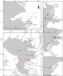
图1
研究区域位置、观测站位及海滩剖面设置图"
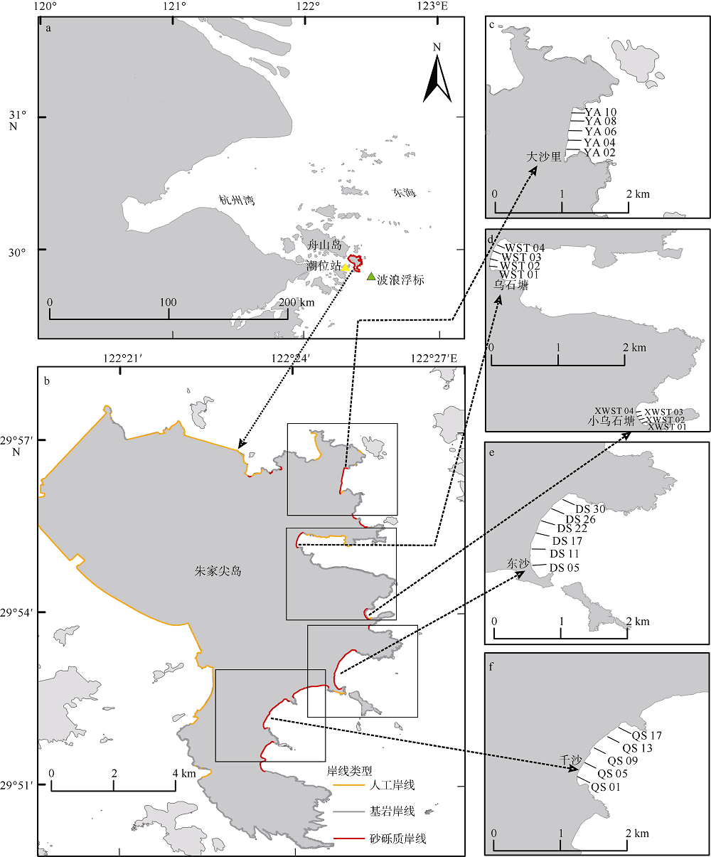
图1
表1
2019年台风季节影响研究区域的台风信息"
| 台风名称 | 最强等级 | 生成时间 | 消亡时间 | 影响研究区域的时间范围 |
|---|---|---|---|---|
| 丹娜丝(Danas) | 强热带风暴 | 7月15日17时 | 7月21日20时 | 7月19日7时—7月19日17时 |
| 利奇马(Lekima) | 超强台风 | 8月4日14时 | 8月13日11时 | 8月9日16时—8月10日1时 |
| 玲玲(Lingling) | 超强台风 | 9月1日20时 | 9月8日10时 | 9月6日13时—9月6日17时 |
| 塔巴(Tapah) | 台风 | 9月18日23时 | 9月23日8时 | 9月21日11时—9月22日5时 |
表1
图2
海滩剖面及沉积物采样站位示意图(以东沙海滩DS11剖面的第二次调查为例)"

图2
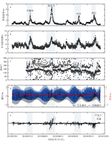
图3
台风季节朱家尖岛近岸海域有效波高(a)、平均波周期(b)、波向(c)、潮位和增水情况(d)以及风速、风向过程(e) 垂直的灰色阴影表示2019年台风季节的4个台风影响研究区域的时间, 图c中2019年7月1日至2019年7月15日的波向因仪器故障而未展示相应数据"

图3
表2
朱家尖岛大沙里、东沙和千沙海滩单宽体积变化统计表"
| 剖面 | 单宽体积变化量/(m3·m-1) | |||
|---|---|---|---|---|
| 台风季节前期 | 台风季节后期 | 整个台风季节 | ||
| 大沙里 | YA02 | -10.72 | 27.29 | 16.58 |
| YA04 | 2.67 | 8.39 | 11.06 | |
| YA06 | 30.98 | 13.30 | 44.28 | |
| YA08 | 2.26 | 11.55 | 13.81 | |
| YA10 | -2.32 | -23.79 | -26.10 | |
| 平均值 | 4.57 | 7.35 | 11.93 | |
| 东沙 | DS05 | 3.49 | -57.03 | -53.54 |
| DS11 | -77.77 | -46.40 | -124.17 | |
| DS17 | -80.73 | -2.65 | -83.39 | |
| DS22 | -9.22 | -32.45 | -41.67 | |
| DS26 | -1.67 | -5.66 | -7.33 | |
| DS30 | -9.03 | -6.95 | -15.97 | |
| 平均值 | -35.68 | -18.82 | -54.51 | |
| 千沙 | QS01 | 5.40 | -13.97 | -8.57 |
| QS05 | 18.82 | -41.74 | -22.92 | |
| QS09 | 27.22 | -9.72 | -9.72 | |
| QS13 | -43.02 | -66.08 | -10.91 | |
| QS17 | -4.91 | -41.73 | -46.63 | |
| 平均值 | 0.70 | -34.65 | -19.75 | |
表2
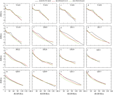
图4
大沙里(a—e)、东沙(f—k)和千沙海滩(l—p)典型剖面在台风季节的变化特征"
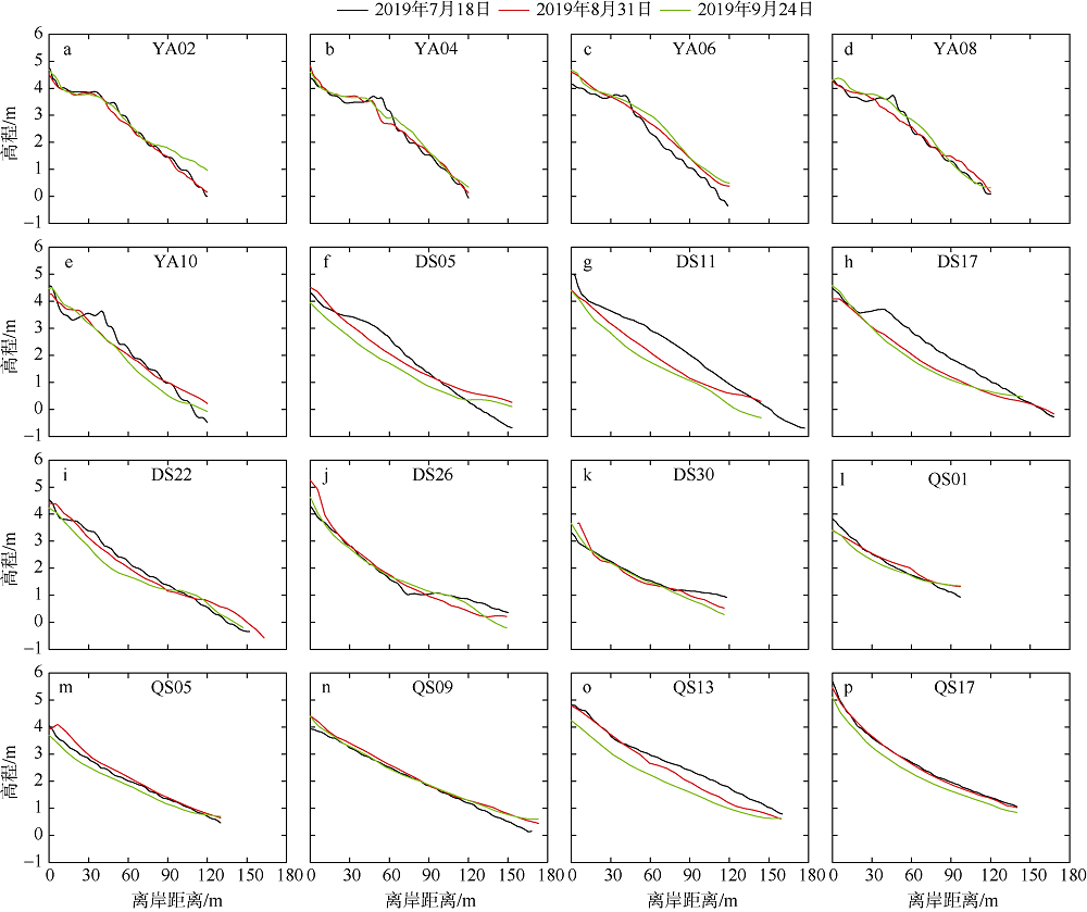
图4
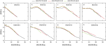
图5
台风季节乌石塘(a—d)、小乌石塘(e—h)海滩的剖面形态变化特征"
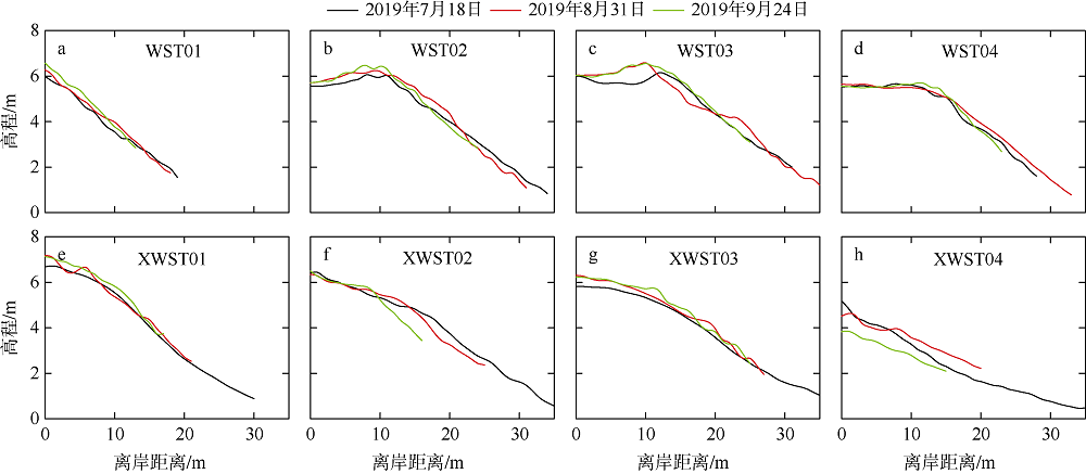
图5
表3
朱家尖岛乌石塘和小乌石塘海滩单宽体积变化统计表"
| 剖面 | 单宽体积变化量/(m3·m-1) | |||
|---|---|---|---|---|
| 台风季节前期 | 台风季节后期 | 整个台风季节 | ||
| 乌石塘 | WST01 | 2.67 | -0.07 | 2.59 |
| WST02 | 5.31 | -3.63 | 1.68 | |
| WST03 | 4.88 | 0.16 | 5.04 | |
| WST04 | 2.32 | -2.90 | -0.58 | |
| 平均值 | 3.80 | -1.61 | 2.18 | |
| 小乌石塘 | XWST01 | 1.80 | 1.16 | 2.96 |
| XWST02 | 0.21 | -6.47 | -6.27 | |
| XWST03 | 6.05 | 0.28 | 6.33 | |
| XWST04 | 2.57 | -13.42 | -10.85 | |
| 平均值 | 2.66 | -4.61 | -1.96 | |
表3
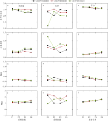
图6
台风季节大沙里(a、d、g、j)、东沙(b、e、h、k)、千沙(c、f、i、l)海滩表层沉积物粒度特征在离岸方向上的变化"
图6
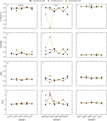
图7
台风季节大沙里(a、d、g、j)、东沙(b、e、h、k)、千沙(c、f、i、l)海滩表层沉积物粒度特征在沿岸方向上的变化"
图7
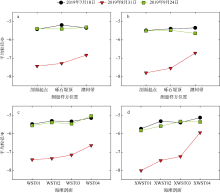
图8
台风季节乌石塘(a、c)、小乌石塘(b、d)海滩表层沉积物的平均粒径变化"
图8
表4
台风季节乌石塘和小乌石塘海滩各剖面表层沉积物的形态参数"
| 剖面 | 2019年7月18日 | 2019年8月31日 | 2019年9月24日 | |||||||||
|---|---|---|---|---|---|---|---|---|---|---|---|---|
| MPS | OPI | DRI | MPS | OPI | DRI | MPS | OPI | DRI | ||||
| 乌石塘 | WST01 | 0.26 | -1.94 | 0.46 | 0.20 | -2.90 | 0.41 | 0.23 | -2.22 | 0.42 | ||
| WST02 | 0.23 | -2.31 | 0.42 | 0.20 | -2.87 | 0.39 | 0.24 | -2.04 | 0.42 | |||
| WST03 | 0.25 | -1.34 | 0.46 | 0.23 | -2.28 | 0.41 | 0.26 | -2.47 | 0.40 | |||
| WST04 | 0.30 | -1.89 | 0.43 | 0.22 | -1.84 | 0.44 | 0.22 | -2.08 | 0.43 | |||
| 平均值 | 0.26 | -1.87 | 0.44 | 0.21 | -2.47 | 0.41 | 0.23 | -2.20 | 0.42 | |||
| 小乌石塘 | XWST01 | 0.23 | -2.43 | 0.41 | 0.23 | -0.12 | 0.50 | 0.22 | -1.82 | 0.44 | ||
| XWST02 | 0.29 | -0.71 | 0.47 | 0.27 | -0.74 | 0.48 | 0.31 | -1.09 | 0.46 | |||
| XWST03 | 0.28 | -1.74 | 0.43 | 0.27 | -0.59 | 0.47 | 0.34 | -0.37 | 0.48 | |||
| XWST04 | 0.37 | -0.03 | 0.51 | 0.21 | -2.07 | 0.43 | 0.33 | 0.06 | 0.51 | |||
| 平均值 | 0.29 | -1.23 | 0.46 | 0.25 | -0.88 | 0.47 | 0.30 | -0.80 | 0.47 | |||
表4
表5
台风季节乌石塘和小乌石塘海滩不同样方位置表层沉积物的形态参数"
| 海滩 | 样方位置 | 2019年7月18日 | 2019年8月31 | 2019年9月24日 | ||||||||
|---|---|---|---|---|---|---|---|---|---|---|---|---|
| MPS | OPI | DRI | MPS | OPI | DRI | MPS | OPI | DRI | ||||
| 乌石塘 | 剖面起点 | 0.25 | -1.82 | 0.45 | 0.21 | -2.87 | 0.41 | 0.22 | -2.59 | 0.40 | ||
| 砾石堤顶 | 0.26 | -2.90 | 0.40 | 0.22 | -2.21 | 0.42 | 0.24 | -2.12 | 0.42 | |||
| 潮间带 | 0.28 | -0.89 | 0.47 | 0.21 | -2.33 | 0.42 | 0.25 | -1.90 | 0.43 | |||
| 小乌石塘 | 剖面起点 | 0.28 | -1.61 | 0.44 | 0.25 | -0.65 | 0.48 | 0.30 | -1.07 | 0.47 | ||
| 砾石堤顶 | 0.28 | -1.61 | 0.44 | 0.22 | -0.58 | 0.48 | 0.28 | -1.10 | 0.46 | |||
| 潮间带 | 0.33 | -0.46 | 0.49 | 0.26 | -1.41 | 0.45 | 0.33 | -0.24 | 0.50 | |||
表5
| [1] | 蔡锋, 苏贤泽, 夏东兴, 2004. 热带气旋前进方向两侧海滩风暴效应差异研究——以海滩对0307号台风“伊布都”的响应为例[J]. 海洋科学进展, 22(4): 436-445. |
| CAI FENG, SU XIANZE, XIA DONGXING, 2004. Study on the difference between storm effects of beaches on two sides of the tropical cyclone track-Taking the responses of beaches to No. 0307 typhoon Imbudo as an example[J]. Advances in Marine Science, 22(4): 436-445 (in Chinese with English abstract) | |
| [2] | 蔡锋, 刘根, 2019. 我国海滩养护修复的发展与技术创新[J]. 应用海洋学学报, 38(4): 452-463. |
| CAI FENG, LIU GEN, 2019. Beach nourishment development and technological innovations in China: An overview[J]. Journal of Applied Oceanography, 38(4): 452-463. (in Chinese with English abstract) | |
| [3] | 陈洪德, 严钦尚, 项立嵩, 1982. 舟山朱家尖岛现代海岸沉积[J]. 华东师范大学学报(自然科学版), (2): 77-91. |
| CHEN HONGDE, YAN QINSHANG, XIANG LISONG, 1982. Recent coastal sediments of Zhujiajian Island, Zhoushan Archipelago[J]. Journal of East China Normal University (Natural Science Edition), (2): 77-91. (in Chinese with English abstract) | |
| [4] | 程林, 时连强, 夏小明, 等, 2014. 浙江朱家尖岛东沙海滩沉积与地貌动态变化[J]. 海洋地质与第四纪地质, 34(1): 37-44. |
| CHENG LIN, SHI LIANQIANG, XIA XIAOMING, et al, 2014. Sedimentation and recent morphological changes at Dongsha beach, Zhujiajian Island, Zhejiang Province[J]. Marine Geology and Quaternary Geology, 34(1): 37-44. (in Chinese with English abstract) | |
| [5] | 程武风, 陈沈良, 胡进, 2017. 海南万宁岬湾海岸海滩稳定性研究[J]. 海洋工程, 35(1): 121-128. |
| CHENG WUFENG, CHEN SHENLIANG, HU JIN, 2017. Stability of headland bay beaches on the east coast of Hainan Island[J]. The Ocean Engineering, 35(1): 121-128. (in Chinese with English abstract) | |
| [6] | 戴志军, 陈子燊, 张清凌, 2001. 波控岬间海滩剖面短期变化过程分析[J]. 热带地理, 21(3): 266-269. |
| DAI ZHIJUN, CHEN ZISHEN, ZHANG QINGLING, 2001. An analysis on temporal variation process of a wave-dominated beach profile between headlands[J]. Tropical Geography, 21(3): 266-269. (in Chinese with English abstract) | |
| [7] | 戴志军, 李春初, 王文介, 等, 2006. 华南弧形海岸的分形和稳定性研究[J]. 海洋学报, 28(1): 176-180. |
| DAI ZHIJUN, LI CHUNCHU, WANG WENJIE, et al, 2006. Research on stability and fractal of arc-shaped coast in South China[J]. Acta Oceanologica Sinica, 28(1): 176-180. (in Chinese with English abstract) | |
| [8] | 高抒, 贾建军, 杨阳, 等, 2019. 陆架海岸台风沉积记录及信息提取[J]. 海洋学报, 41(10): 141-160. |
| GAO SHU, JIA JIANJUN, et al, 2019. Obtaining typhoon information from sedimentary records in coastal-shelf waters[J]. Haiyang Xuebao, 41(10): 141-160. (in Chinese with English abstract) | |
| [9] | 龚昊, 陈沈良, 钟小菁, 等, 2017. 海南岛东北部海滩侵蚀与恢复对连续台风的复杂响应[J]. 海洋学报, 39(5): 68-77. |
| GONG HAO, CHEN SHENLIANG, ZHONG XIAOJING, et al, 2017. Complicated responses of beach erosion and restoration to consecutive typhoons along northeastern Hainan Island, China[J]. Haiyang Xuebao, 39(5): 68-77. (in Chinese with English abstract) | |
| [10] | 郭俊丽, 时连强, 童宵岭, 等, 2018. 浙江朱家尖岛东沙海滩对热带风暴“娜基莉”的响应及风暴后的恢复[J]. 海洋学报, 40(9): 137-147. |
| GUO JUNLI, SHI LIANQIANG, TONG XIAOLING, et al, 2018. The response to tropical storm Nakri and the restoration of Dongsha beach in Zhujiajian Island, Zhejiang province[J]. Haiyang Xuebao, 40(9): 137-147. (in Chinese with English abstract) | |
| [11] | 郭俊丽, 时连强, 陈沈良, 等, 2019. 基于Argus图像的舟山东沙海滩对连续风暴的响应研究[J]. 海洋与湖沼, 50(4): 728-739. |
| GUO JUNLI, SHI LIANQIANG, CHEN SHENLIANG, et al, 2019. Response of Dongsha beach in Zhoushan to continuous storms based on Argus images[J]. Oceanologia et Limnologia Sinica, 50(4): 728-739. (in Chinese with English abstract) | |
| [12] | 李志龙, 陈子燊, 2006. 岬间砂质海岸平衡形态模型及其在华南海岸的应用[J]. 台湾海峡, 25(1): 123-129. |
| LI ZHILONG, CHEN ZISHEN, 2006. Equilibrium shape model of headland-bay and application in South China coasts[J]. Journal of Oceanography in Taiwan Strait, 25(1): 123-129. (in Chinese with English abstract) | |
| [13] | 束芳芳, 蔡锋, 戚洪帅, 等, 2019. 不同沉积物养护海滩对台风响应的差异性研究[J]. 海洋学报, 41(7): 103-115. |
| SHU FANGFANG, CAI FENG, QI HONGSHUAI, et al, 2019. Study on various response to typhoon of nourished beaches with different sediments[J]. Haiyang Xuebao, 41(7): 103-115. (in Chinese with English abstract) | |
| [14] | 童宵岭, 时连强, 夏小明, 等, 2014. 1211号台风对浙江象山皇城海滩剖面的影响分析[J]. 海洋工程, 32(1): 84-90. |
| TONG XIAOLING, SHI LIANQIANG, XIA XIAOMING, et al, 2014. Response of sedimentary and geomorphic characteristics to 1211 typhoon on Zhejiang Huangcheng beach[J]. The Ocean Engineering, 32(1): 84-90. (in Chinese with English abstract) | |
| [15] | 王爱军, 高抒, 杨旸, 2004. 浙江朱家尖岛砾石海滩沉积物分布及形态特征[J]. 南京大学学报(自然科学), 40(6): 747-759. |
| WANG AIJUN, GAO SHU, 2004. Sediment distribution and shape characteristics of gravel beaches, Zhujiajian Island, Zhejiang province[J]. Journal of Nanjing University (Natural Sciences), 40(6): 747-759. (in Chinese with English abstract) | |
| [16] | 夏小明, 2014. 中国海岛志-第2册-浙江卷, 舟山群岛南部[M]. 北京: 海洋出版社. (in Chinese) |
| [17] | 许浩恩, 陈海燕, 赵璐, 2009. 浙江影响热带气旋的几个统计特征[J]. 浙江气象, 30(2): 4-8, 21. (in Chinese) |
| [18] | 曾春华, 朱士兵, 李志强, 等, 2020. 基于高频观测数据的徐闻青安湾海滩对台风“贝碧嘉”的响应研究[J]. 海洋学报, 42(11): 100-111. |
| ZENG CHUNHUA, ZHU SHIBING, LI ZHIQIANG, et al, 2020. Response of the Qing’an Bay beach in Xuwen to Typhoon Bebinca based on high frequency observation data[J]. Haiyang Xuebao, 42(11): 100-111. (in Chinese with English abstract) | |
| [19] | 张国栋, 王益友, 朱静昌, 等, 1987. 现代滨岸风暴沉积——以舟山普陀岛、朱家法岛为例[J]. 沉积学报, 5(2): 17-28. |
| ZHANG GUODONG, WANG YIYOU, ZHU JINGCHANG, et al, 1987. Modern coastal storm deposits of Putuo Island and Zhujiajian Island, Zhoushan[J]. Acta Sedimentologica Sinica, 5(2): 17-28. (in Chinese with English abstract) | |
| [20] | 朱士兵, 李志强, 2019. 雷州半岛南部海滩对1720号台风(卡努)的响应研究[J]. 热带海洋学报, 38(1): 96-104. |
| ZHU SHIBING, LI ZHIQIANG, 2019. Study on beach response to Typhoon Khanun (NO. 1720) along southern Leizhou Peninsula[J]. Journal of Tropical Oceanography, 38(1): 96-104. (in Chinese with English abstract) | |
| [21] | 庄振业, 王永红, 包敏, 等, 2009. 海滩养护过程和工程技术[J]. 中国海洋大学学报(自然科学版), 39(5): 1019-1024. |
| ZHUANG ZHENYE, WANG YONGHONG, BAO MIN, et al, 2009. Beach nourishment process and engineering technology[J]. Periodical of Ocean University of China, 39(5): 1019-1024. (in Chinese with English abstract) | |
| [22] |
ANTHONY E J, 2013. Storms, shoreface morphodynamics, sand supply, and the accretion and erosion of coastal dune barriers in the southern North Sea[J]. Geomorphology, 199: 8-21.
doi: 10.1016/j.geomorph.2012.06.007 |
| [23] |
BENN D I, BALLANTYNE C K, 1993. The description and representation of particle shape[J]. Earth Surface Processes and Landforms, 18(7): 665-672.
doi: 10.1002/esp.3290180709 |
| [24] |
BURVINGT O, MASSELINK G, SCOTT T, et al, 2018. Climate forcing of regionally-coherent extreme storm impact and recovery on embayed beaches[J]. Marine Geology, 401: 112-128.
doi: 10.1016/j.margeo.2018.04.004 |
| [25] | CAI FENG, DEAN R G, LIU JIANHUI, 2011. Beach nourishment in China: Status and prospects[C]// Coastal Engineering Proceedings, Shanghai. |
| [26] | CARVER R E, 1971. Procedures in sedimentary petrology[M]. New York: Wiley-Interscience. |
| [27] |
CASTELLE B, MARIEU V, BUJAN S, et al, 2015. Impact of the winter 2013-2014 series of severe Western Europe storms on a double-barred sandy coast: Beach and dune erosion and megacusp embayments[J]. Geomorphology, 238: 135-148.
doi: 10.1016/j.geomorph.2015.03.006 |
| [28] |
CASTELLE B, TURNER I L, BERTIN X, et al, 2009. Beach nourishments at Coolangatta Bay over the period 1987-2005: Impacts and lessons[J]. Coastal Engineering, 56(9): 940-950.
doi: 10.1016/j.coastaleng.2009.05.005 |
| [29] |
COOPER J A G, MCKENNA J, 2008. Social justice in coastal erosion management: The temporal and spatial dimensions[J]. Geoforum, 39(1): 294-306.
doi: 10.1016/j.geoforum.2007.06.007 |
| [30] |
COSTAS S, ALEJO I, VILA-CONCEJO A, et al, 2005. Persistence of storm-induced morphology on a modal low-energy beach: A case study from NW-Iberian Peninsula[J]. Marine Geology, 224(1-4): 43-56.
doi: 10.1016/j.margeo.2005.08.003 |
| [31] |
DAI ZHIJUN, DU JINZHOU, LI CHUNCHU, et al, 2007. The configuration of equilibrium beach profile in South China[J]. Geomorphology, 86(3-4): 441-454.
doi: 10.1016/j.geomorph.2006.09.016 |
| [32] | DOBKINS J E, FOLK R L, 1970. Shape development on Tahiti-Nui[J]. Journal of Sedimentary Petrology, 40(4): 1167-1203. |
| [33] |
FOLK R L, WARD W C, 1957. Brazos River bar [Texas]: A study in the significance of grain size parameters[J]. Journal of Sedimentary Research, 27(1): 3-26.
doi: 10.1306/74D70646-2B21-11D7-8648000102C1865D |
| [34] |
GE ZHENPENG, DAI ZHIJUN, PANG WENHONG, et al, 2017. LIDAR-based detection of the post-typhoon recovery of a meso-macro-tidal beach in the Beibu Gulf, China[J]. Marine Geology, 391: 127-143.
doi: 10.1016/j.margeo.2017.08.008 |
| [35] |
GUO JUNLI, SHI LIANGQIANG, PAN SHUNQI, et al, 2020. Monitoring and evaluation of sand nourishments on an embayed beach exposed to frequent storms in eastern China[J]. Ocean and Coastal Management, 195: 105284.
doi: 10.1016/j.ocecoaman.2020.105284 |
| [36] |
HAERENS P, BOLLE A, TROUW K, et al, 2012. Definition of storm thresholds for significant morphological change of the sandy beaches along the Belgian coastline[J]. Geomorphology, 143-144: 104-117.
doi: 10.1016/j.geomorph.2011.09.015 |
| [37] |
HAMM L, CAPOBIANCO M, DETTE H H, et al, 2002. A summary of European experience with shore nourishment[J]. Coastal Engineering, 47(2): 237-264.
doi: 10.1016/S0378-3839(02)00127-8 |
| [38] |
HANSON H, BRAMPTON A, CAPOBIANCO M, et al, 2002. Beach nourishment projects, practices, and objectives—a European overview[J]. Coastal Engineering, 47(2): 81-111.
doi: 10.1016/S0378-3839(02)00122-9 |
| [39] |
HARLEY M D, ANDRIOLO U, ARMAROLI C, et al, 2014. Shoreline rotation and response to nourishment of a gravel embayed beach using a low-cost video monitoring technique: San Michele-Sassi Neri, Central Italy[J]. Journal of Coastal Conservation, 18(5): 551-565.
doi: 10.1007/s11852-013-0292-x |
| [40] | KOMAR P D, 1976. Beach processes and sedimentation[M]. Englewood Cliffs: Prentice-Hall. |
| [41] |
KUANG CUIPING, MAO XIAODAN, GU JIE, et al, 2019. Morphological processes of two artificial submerged shore-parallel sandbars for beach nourishment in a nearshore zone[J]. Ocean and Coastal Management, 179: 104870.
doi: 10.1016/j.ocecoaman.2019.104870 |
| [42] |
LOUREIRO C, FERREIRA Ó, COOPER J A G, 2012. Geologically constrained morphological variability and boundary effects on embayed beaches[J]. Marine Geology, 329-331: 1-15.
doi: 10.1016/j.margeo.2012.09.010 |
| [43] |
LUO SHILONG, LIU YUHENG, JIN RUIFANG, et al, 2016. A guide to coastal management: Benefits and lessons learned of beach nourishment practices in China over the past two decades[J]. Ocean and Coastal Management, 134: 207-215.
doi: 10.1016/j.ocecoaman.2016.10.011 |
| [44] |
MASSELINK G, SCOTT T, POATE T, et al, 2016. The extreme 2013/2014 winter storms: hydrodynamic forcing and coastal response along the southwest coast of England[J]. Earth Surface Processes and Landforms, 41(3): 378-391.
doi: 10.1002/esp.3836 |
| [45] |
PETERSON C H, BISHOP M J, JOHNSON G A, et al, 2006. Exploiting beach filling as an unaffordable experiment: Benthic intertidal impacts propagating upwards to shorebirds[J]. Journal of Experimental Marine Biology and Ecology, 338(2): 205-221.
doi: 10.1016/j.jembe.2006.06.021 |
| [46] | POWERS M C, 1953. A new roundness scale for sedimentary particles[J]. Journal of Sedimentary Petrology, 23(2): 117-119. |
| [47] |
PRODGER S, RUSSELL P, DAVIDSON M, et al, 2016. Understanding and predicting the temporal variability of sediment grain size characteristics on high-energy beaches[J]. Marine Geology, 376: 109-117.
doi: 10.1016/j.margeo.2016.04.003 |
| [48] |
QI HONGSHUAI, CAI FENG, LEI GANG, et al, 2010. The response of three main beach types to tropical storms in South China[J]. Marine Geology, 275(1-4): 244-254.
doi: 10.1016/j.margeo.2010.06.005 |
| [49] |
SEYMOUR R, GUZA R T, O’REILLY W, et al, 2005. Rapid erosion of a small southern California beach fill[J]. Coastal Engineering, 52(2): 151-158.
doi: 10.1016/j.coastaleng.2004.10.003 |
| [50] |
SNEED E D, FOLK R L, 1958. Pebbles in the lower Colorado River, Texas a study in particle morphogenesis[J]. The Journal of Geology, 66(2): 114-150.
doi: 10.1086/626490 |
| [1] | 姜迅, 武文, 宋德海. 大亚湾水质对人类活动响应的关键控制指标识别和量化解析[J]. 热带海洋学报, 2023, 42(1): 182-191. |
| [2] | 马玉婷, 蔡华阳, 杨昊, 刘锋, 陈欧, 谢荣耀, 欧素英, 杨清书. 珠江磨刀门河口水位分布演变特征及其对人类活动的响应*[J]. 热带海洋学报, 2022, 41(2): 52-64. |
| [3] | 杨留柱, 杨莉玲, 潘洪州, 刘超群, 喻丰华. 人类活动影响下的钦州湾近期滩槽冲淤演变特征[J]. 热带海洋学报, 2019, 38(6): 41-50. |
|
||