
热带海洋学报 ›› 2021, Vol. 40 ›› Issue (6): 1-13.doi: 10.11978/2020110CSTR: 32234.14.2020110
• 综述 • 下一篇
海草光学遥感监测研究综述
李一琼1,3( ), 白俊武1(), 张丽2,3, 李通2,4
- 1.苏州科技大学地理科学与测绘工程学院, 江苏 苏州 215009
2.中国科学院空天信息创新研究院数字地球重点实验室, 北京 100094
3.海南省地球观测重点实验室, 海南 三亚 572029
4.北京电子工程总体研究所, 北京 100039
-
收稿日期:2020-09-20修回日期:2020-11-22出版日期:2021-11-10发布日期:2020-12-21 -
通讯作者:白俊武 -
作者简介:李一琼(1985—), 女, 陕西省咸阳市人, 博士, 从事生态环境遥感监测及GIS应用研究。email:yiqiongli@mail.usts.edu.cn 。 -
基金资助:中国科学院战略性先导科技专项(A类)(XDA13020506);江苏省自然科学基金(BK20170379);苏州科技大学校科研基金(XKZ2019009)
Review on the research of seagrass optical remote sensing monitoring
LI Yiqiong1,3(), BAI Junwu1(), ZHANG Li2,3, LI Tong2,4
- 1. School of Geographic Sciences & Surveying and Mapping Engineering, Suzhou University of Science and Technology, Suzhou 215009, China
2. Key Laboratory of Digital Earth Science, Aerospace Information Research Institute, Chinese Academy of Sciences, Beijing 100094, China
3. Hainan Key Laboratory of Earth Observation, Sanya 572029, China
4. Beijing Institute of Electronic System Engineering, Beijing 100039, China
-
Received:2020-09-20Revised:2020-11-22Online:2021-11-10Published:2020-12-21 -
Contact:BAI Junwu -
Supported by:Strategic Priority Research Program of the Chinese Academy of Sciences(XDA13020506);Natural Science Foundation of Jiangsu Province(BK20170379);Scientific Research Fund project of Suzhou University of Science and Technology(XKZ2019009)
摘要:
海草生长在热带、亚热带和温带海洋水域, 是全球海洋生态系统中重要的结构和功能组成部分, 具有极高的生态服务价值。由于受到人类活动和自然灾害的强烈影响, 海草正在全球范围内快速衰退, 因此开展海草资源监测与保护具有非常重要的意义。随着传感器技术的发展, 光学遥感在海草监测中表现出卓越优势。本文综述了国内外海草遥感监测研究现状, 重点总结了研究内容、技术和方法, 论证了海草光学遥感监测的可行性, 旨在为我国海草光学遥感监测厘清适宜数据和可靠技术方法, 并指明潜在研究方向。同时也希望能为海草遥感监测提供借鉴, 并拓展海草资源科学管理的思路。
中图分类号:
- Q948.8
引用本文
李一琼, 白俊武, 张丽, 李通. 海草光学遥感监测研究综述[J]. 热带海洋学报, 2021, 40(6): 1-13.
LI Yiqiong, BAI Junwu, ZHANG Li, LI Tong. Review on the research of seagrass optical remote sensing monitoring[J]. Journal of Tropical Oceanography, 2021, 40(6): 1-13.
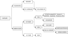
图1
目前海草监测方法"

图1
表1
不同传感器数据开展海草监测任务的适宜性"
| 传感器名称 | 监测任务 | 数据适宜性 | ||||||
|---|---|---|---|---|---|---|---|---|
| 海草底栖生境 | 海草覆盖度变化 | 海草生 物量 | 海草群落结构 | 空间 范围 | 制图 精度 | 获取 成本 | ||
| 较粗划分 | 细致划分 | |||||||
| 高分辨率IKONOS、Quickbird、Wordview-2等 | 可行 | 可行 | 可行 | 较小 | 较高 | 高昂 | ||
| 中低分辨率Landsat TM/ETM+/OLI、Sentinel-2等 | 可行 | 可行 | 可行 | 大 | 偏低 | 低廉 | ||
| 高光谱Hyperion等 | 可行 | 可行 | 较小 | 较高 | 高昂 | |||
| 低空无人机相机 | 可行 | 可行 | 可行 | 可行 | 小 | 高 | 中等 | |
表1
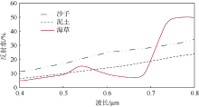
图2
海草的光谱反射率曲线(Lyzenga, 1978)"
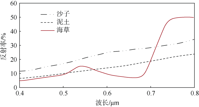
图2
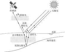
图3
海草遥感辐射传输过程"
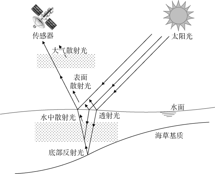
图3
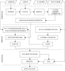
图4
基于光学遥感影像的海草地图绘制流程(Misbari et al, 2016)"

图4
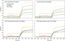
图5
3种海草的光谱特征及波长(曲线值取其平均值±标准差)相关结果引用自Hossain等(2015)和Fyfe(2003)"
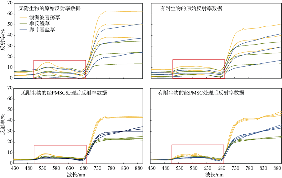
图5
| [1] | 陈石泉, 王道儒, 吴钟解, 等, 2015a. 海南岛东海岸海草床近10A变化趋势探讨[J]. 海洋环境科学, 34(1):48-53. |
| CHEN SHIQUAN, WANG DAORU, WU ZHONGJIE, et al, 2015a. Discussion of the change trend of the seagrass beds in the east coast of Hainan Island in nearly a decade[J]. Marine Environmental Science, 34(1):48-53 (in Chinese with English abstract). | |
| [2] | 陈石泉, 吴钟解, 陈晓慧, 等, 2015b. 海南岛南部海草资源分布现状调查分析[J]. 海洋学报, 37(6):106-113. |
| CHEN SHIQUAN, WU ZHONGJIE, CHEN XIAOHUI, et al, 2015b. Investigation and analysis of the distribution status of seagrass resources in the southern part of Hainan Island[J]. Haiyang Xuebao, 37(6):106-113 (in Chinese with English abstract). | |
| [3] | 黄荣永, 余克服, 王英辉, 等, 2019. 珊瑚礁遥感研究进展[J]. 遥感学报, 23(6):1091-1112. |
| HUANG RONGYONG, YU KEFU, WANG YINGHUI, et al, 2019. Progress of the study on coral reef remote sensing[J]. Journal of Remote Sensing, 23(6):1091-1112 (in Chinese with English abstract). | |
| [4] | 黄小平, 黄良民, 李颖虹, 等, 2006. 华南沿海主要海草床及其生境威胁[J]. 科学通报, 51(S3):114-119. |
| HUANG XIAOPING, HUANG LIANGMIN, LI YINGHONG, et al, 2006. Main seagrass beds and threats to their habitats in the coastal sea of South China[J]. Chinese Science Bulletin, 51:136-142. | |
| [5] | 黄小平, 江志坚, 张景平, 等, 2018. 全球海草的中文命名[J]. 海洋学报, 40(4):127-133. |
| HUANG XIAOPING, JIANG ZHIJIAN, ZHANG JINGPING, et al, 2018. The Chinese nomenclature of the global seagrasses[J]. Haiyang Xuebao, 40(4):127-133 (in Chinese with English abstract). | |
| [6] | 王道儒, 吴钟解, 陈春华, 等, 2012. 海南岛海草资源分布现状及存在威胁[J]. 海洋环境科学, 31(1):34-38. |
| WANG DAORU, WU ZHONGJIE, CHEN CHUNHUA, et al, 2012. Distribution of sea-grass resources and existing threat in Hainan Island[J]. Marine Environmental Science, 31(1):34-38 (in Chinese with English abstract). | |
| [7] | 杨超宇, 杨顶田, 赵俊, 2010. 光学浅水海草高光谱识别[J]. 热带海洋学报, 29(2):74-79. |
| YANG CHAOYU, YANG DINGTIAN, ZHAO JUN, 2010. Hyperspectral recognition of seagrass in optically shallow water[J]. Journal of Tropical Oceanography, 29(2):74-79 (in Chinese with English abstract). | |
| [8] | 杨顶田, 2007. 海草的卫星遥感研究进展[J]. 热带海洋学报, 26(4):82-86. |
| YANG DINGTIAN, 2007. Progress in research of seagrass remote sensing[J]. Journal of Tropical Oceanography, 26(4):82-86 (in Chinese with English abstract). | |
| [9] | 杨顶田, 刘素敏, 单秀娟, 2013. 海草碳通量的卫星遥感检测研究进展[J]. 热带海洋学报, 32(6):108-114. |
| YANG DINGTIAN, LIU SUMIN, SHAN XIUJUAN, 2013. Progress in detecting seagrass carbon flux over optically shallow water using satellite remote sensing[J]. Journal of Tropical Oceanography, 32(6):108-114 (in Chinese with English abstract). | |
| [10] | 杨宗岱, 1979. 中国海草植物地理学的研究[J]. 海洋湖沼通报, (2):41-46. |
| YANG ZONGDAI, 1979. The geographical distribution of sea-grasses[J]. Transaction of Oceanology and Limnology, (2):41-46 (in Chinese with English abstract). | |
| [11] |
郑凤英, 邱广龙, 范航清, 等, 2013. 中国海草的多样性、分布及保护[J]. 生物多样性, 21(5):517-526.
doi: 10.3724/SP.J.1003.2013.10038 |
|
ZHENG FENGYING, QIU GUANGLONG, FAN HANGQING, et al, 2013. Diversity, distribution and conservation of Chinese seagrass species[J]. Biodiversity Science, 21(5):517-526 (in Chinese with English abstract).
doi: 10.3724/SP.J.1003.2013.10038 |
|
| [12] | 周元慧, 胡刚, 张忠华, 等, 2019. 基于Web of Science的国际海草研究文献计量评价[J]. 生态学报, 39(11):4200-4211. |
| ZHOU YUANHUI, HU GANG, ZHANG ZHONGHUA, et al, 2019. Bibliometric assessment of international seagrass research using the web of science database[J]. Acta Ecologica Sinica, 39(11):4200-4211 (in Chinese with English abstract). | |
| [13] |
BAJJOUK T, MOUQUET P, ROPERT M, et al, 2019. Detection of changes in shallow coral reefs status: towards a spatial approach using hyperspectral and multispectral data[J]. Ecological Indicators, 96:174-191.
doi: 10.1016/j.ecolind.2018.08.052 |
| [14] |
BARILLÉ L, ROBIN M, HARIN N, et al, 2010. Increase in seagrass distribution at Bourgneuf Bay (France) detected by spatial remote sensing[J]. Aquatic Botany, 92(3):185-194.
doi: 10.1016/j.aquabot.2009.11.006 |
| [15] |
BAUMSTARK R, DIXON B, CARLSON P, et al, 2013. Alternative spatially enhanced integrative techniques for mapping seagrass in Florida's marine ecosystem[J]. International Journal of Remote Sensing, 34(4):1248-1264.
doi: 10.1080/01431161.2012.721941 |
| [16] |
BAUMSTARK R, DUFFEY R, PU RUILIANG, 2016. Mapping seagrass and colonized hard bottom in Springs Coast, Florida using WorldView-2 satellite imagery[J]. Estuarine, Coastal and Shelf Science, 181:83-92.
doi: 10.1016/j.ecss.2016.08.019 |
| [17] |
BONGIORNO D L, BRYSON M, BRIDGE T C L, et al, 2018. Coregistered hyperspectral and stereo image seafloor mapping from an autonomous underwater vehicle[J]. Journal of Field Robotics, 35(3):312-329.
doi: 10.1002/rob.2018.35.issue-3 |
| [18] |
BORFECCHIA F, CONSALVI N, MICHELI C, et al, 2019. Landsat 8 OLI satellite data for mapping of the Posidonia oceanica and benthic habitats of coastal ecosystems[J]. International Journal of Remote Sensing, 40(4):1548-1575.
doi: 10.1080/01431161.2018.1528020 |
| [19] |
BRAMANTE J F, ALI S M, ZIEGLER A D, et al, 2018. Decadal biomass and area changes in a multi-species meadow in Singapore: Application of multi-resolution satellite imagery[J]. Botanica Marina, 61(3):289-304.
doi: 10.1515/bot-2017-0064 |
| [20] |
CARLSON D F, YARBRO L A, SCOLARO S, et al, 2018. Sea surface temperatures and seagrass mortality in Florida Bay: Spatial and temporal patterns discerned from MODIS and AVHRR data[J]. Remote Sensing of Environment, 208:171-188.
doi: 10.1016/j.rse.2018.02.014 |
| [21] |
CHEN C F, LAU V K, CHANG N B, et al, 2016. Multi-temporal change detection of seagrass beds using integrated Landsat TM/ETM +/OLI imageries in Cam Ranh Bay, Vietnam[J]. Ecological Informatics, 35:43-54.
doi: 10.1016/j.ecoinf.2016.07.005 |
| [22] |
DAVENPORT A E, DAVIS J D, WOO I, et al, 2017. Comparing automated classification and digitization approaches to detect change in eelgrass bed extent during restoration of a large river delta[J]. Northwest Science, 91(3):272-282.
doi: 10.3955/046.091.0307 |
| [23] |
DIERSSEN H M, BOSTROM K J, CHLUS A, et al, 2019. Pushing the limits of seagrass remote sensing in the turbid waters of Elkhorn Slough, California[J]. Remote Sensing, 11(14):1664.
doi: 10.3390/rs11141664 |
| [24] |
DUARTE C M, 2002. The future of seagrass meadows[J]. Environmental Conservation, 29(2):192-206.
doi: 10.1017/S0376892902000127 |
| [25] |
DUFFY J P, PRATT L, ANDERSON K, et al, 2018. Spatial assessment of intertidal seagrass meadows using optical imaging systems and a lightweight drone[J]. Estuarine, Coastal and Shelf Science, 200:169-180.
doi: 10.1016/j.ecss.2017.11.001 |
| [26] |
FOURQUREAN J W, DUARTE C M, KENNEDY H, et al, 2012. Seagrass ecosystems as a globally significant carbon stock[J]. Nature Geoscience, 5:505-509.
doi: 10.1038/ngeo1477 |
| [27] |
FYFE S K, 2003. Spatial and temporal variation in spectral reflectance: are seagrass species spectrally distinct?[J]. Limnology and Oceanography, 48(1):464-479.
doi: 10.4319/lo.2003.48.1_part_2.0464 |
| [28] |
GARCIA R A, HEDLEY J D, TIN H C, et al, 2015. A method to analyze the potential of optical remote sensing for benthic habitat mapping[J]. Remote Sensing, 7(10):13157-13189.
doi: 10.3390/rs71013157 |
| [29] |
HOSSAIN M S, BUJANG J S, ZAKARIA M H, et al, 2015. The application of remote sensing to seagrass ecosystems: an overview and future research prospects[J]. International Journal of Remote Sensing, 36(1):61-114.
doi: 10.1080/01431161.2014.990649 |
| [30] |
HUANG XIAOPING, HUANG LIANGMIN, LI YINGHONG, et al, 2006. Main seagrass beds and threats to their habitats in the coastal sea of South China[J]. Chinese Science Bulletin, 51:136-142.
doi: 10.1007/s11434-006-9136-5 |
| [31] |
IMMORDINO F, BARSANTI M, CANDIGLIOTA E, et al, 2019. Application of Sentinel-2 multispectral data for habitat mapping of Pacific Islands: Palau republic (Micronesia, Pacific Ocean)[J]. Journal of Marine Science and Engineering, 7(9):316.
doi: 10.3390/jmse7090316 |
| [32] |
KIM K, CHOI J K, RYU J H, et al, 2015. Observation of typhoon-induced seagrass die-off using remote sensing[J]. Estuarine, Coastal and Shelf Science, 154:111-121.
doi: 10.1016/j.ecss.2014.12.036 |
| [33] |
KNUDBY A, NEWMAN C, SHAGHUDE Y, et al, 2010. Simple and effective monitoring of historic changes in nearshore environments using the free archive of Landsat imagery[J]. International Journal of Applied Earth Observation and Geoinformation, 12(S1):S116-S122.
doi: 10.1016/j.jag.2009.09.002 |
| [34] | KONAR B, IKEN K, 2018. The use of unmanned aerial vehicle imagery in intertidal monitoring[J]. Deep Sea Research Part Ⅱ: Topical Studies in Oceanography, 147:79-86. |
| [35] |
KOVACS E, ROELFSEMA C, LYONS M, et al, 2018. Seagrass habitat mapping: How do Landsat 8 OLI, Sentinel-2, ZY-3A, and Worldview-3 perform?[J]. Remote Sensing Letters, 9(7):686-695.
doi: 10.1080/2150704X.2018.1468101 |
| [36] | LEVINGS C D, NORTH M S, PIERCEY G E, et al, 1999. Mapping Nearshore and intertidal marine habitats with remote sensing and GPS: The importance of spatial and temporal scales[C]// Oceans '99. MTS/IEEE. Riding the Crest into the 21st Century. Conference and Exhibition. Conference Proceedings. Seattle, WA, USA: IEEE: 1249-1255. |
| [37] |
LYONS M B, PHINN S R, ROELFSEMA C M, 2012. Long term land cover and seagrass mapping using Landsat and object-based image analysis from 1972 to 2010 in the coastal environment of South East Queensland, Australia[J]. ISPRS Journal of Photogrammetry and Remote Sensing, 71:34-46.
doi: 10.1016/j.isprsjprs.2012.05.002 |
| [38] |
LYZENGA D R, 1978. Passive remote sensing techniques for mapping water depth and bottom features[J]. Applied Optics, 17(3):379-383.
doi: 10.1364/AO.17.000379 |
| [39] |
LYZENGA D R, 1981. Remote sensing of bottom reflectance and water attenuation parameters in shallow water using aircraft and Landsat data[J]. International Journal of Remote Sensing, 2(1):71-82.
doi: 10.1080/01431168108948342 |
| [40] |
MISBARI S, HASHIM M, 2016. Change detection of submerged seagrass biomass in shallow coastal water[J]. Remote Sensing, 8(3):200.
doi: 10.3390/rs8030200 |
| [41] |
MUMBY P J, GREEN E P, EDWARDS A J, et al, 1999. The cost-effectiveness of remote sensing for tropical coastal resources assessment and management[J]. Journal of Environmental Management, 55(3):157-166.
doi: 10.1006/jema.1998.0255 |
| [42] |
MUMBY P J, EDWARDS A J, 2002. Mapping marine environments with IKONOS imagery: enhanced spatial resolution can deliver greater thematic accuracy[J]. Remote Sensing of Environment, 82(2-3):248-257.
doi: 10.1016/S0034-4257(02)00041-X |
| [43] |
NAHIRNICK N K, HUNTER P, COSTA M, et al, 2019. Benefits and challenges of UAS imagery for eelgrass (Zostera marina) mapping in small estuaries of the Canadian west coast[J]. Journal of Coastal Research, 35(3):673-683.
doi: 10.2112/JCOASTRES-D-18-00079.1 |
| [44] |
ORTH R J, CARRUTHERS T J B, DENNISON W C, et al, 2006. A global crisis for seagrass ecosystems[J]. BioScience, 56(12):987-996.
doi: 10.1641/0006-3568(2006)56[987:AGCFSE]2.0.CO;2 |
| [45] | PALAFOX-JUÁREZ E B, DE LOS ÁNGELES LICEAGA-CORREA M, 2017. Spatial diversity of a coastal seascape: Characterization, analysis and application for conservation[J]. Ocean & Coastal Management, 136:185-195. |
| [46] |
PASQUALINI V, PERGENT-MARTINI C, PERGENT G, et al, 2005. Use of SPOT 5 for mapping seagrasses: an application to Posidonia oceanica[J]. Remote Sensing of Environment, 94(1):39-45.
doi: 10.1016/j.rse.2004.09.010 |
| [47] |
PHINN S R, KOVACS E M, ROELFSEMA C M, et al, 2018. Assessing the potential for satellite image monitoring of seagrass thermal dynamics: For inter- and shallow sub-tidal seagrasses in the inshore Great Barrier Reef World Heritage Area, Australia[J]. International Journal of Digital Earth, 11(8):803-824.
doi: 10.1080/17538947.2017.1359343 |
| [48] | PU RUILIANG, BELL S, BAGGETT L, et al, 2012. Discrimination of seagrass species and cover classes with in situ hyperspectral data[J]. Journal of Coastal Research, 28(6):1330-1344. |
| [49] |
PU RUILIANG, BELL S, MEYER C, 2014. Mapping and assessing seagrass bed changes in Central Florida's west coast using multitemporal Landsat TM imagery[J]. Estuarine, Coastal and Shelf Science, 149:68-79.
doi: 10.1016/j.ecss.2014.07.014 |
| [50] |
PU RUILIANG, BELL S, 2017. Mapping seagrass coverage and spatial patterns with high spatial resolution IKONOS imagery[J]. International Journal of Applied Earth Observation and Geoinformation, 54:145-158.
doi: 10.1016/j.jag.2016.09.011 |
| [51] | REBEKAH S, INAMDAR A B, 2018. Mapping the distribution of coral reef extent and its temporal variation in Gulf of Mannar-comparison of pixel and object based approach[J]. Indian Journal of Geo-Marine Sciences, 47(3):549-557. |
| [52] |
SAGAWA T, BOISNIER E, KOMATSU T, et al, 2010. Using bottom surface reflectance to map coastal marine areas: A new application method for Lyzenga's model[J]. International Journal of Remote Sensing, 31(12):3051-3064.
doi: 10.1080/01431160903154341 |
| [53] |
SANTOS R O, VARONA G, AVILA C L, et al, 2020. Implications of macroalgae blooms to the spatial structure of seagrass seascapes: The case of the Anadyomene Spp. (Chlorophyta) Bloom in Biscayne Bay, Florida[J]. Marine Pollution Bulletin, 150:110742.
doi: 10.1016/j.marpolbul.2019.110742 |
| [54] |
SHORT F T, POLIDORO B, LIVINGSTONE S R, et al, 2011. Extinction risk assessment of the world's seagrass species[J]. Biological Conservation, 144(7):1961-1971.
doi: 10.1016/j.biocon.2011.04.010 |
| [55] |
SHORT F T, WYLLIE-ECHEVERRIA S, 1996. Natural and human-induced disturbance of seagrasses[J]. Environmental Conservation, 23(1):17-27.
doi: 10.1017/S0376892900038212 |
| [56] |
SOUSA A I, DA SILVA J F, AZEVEDO A, et al, 2019. Blue carbon stock in Zostera noltei meadows at Ria De Aveiro coastal lagoon (Portugal) over a decade[J]. Scientific Reports, 9:14387.
doi: 10.1038/s41598-019-50425-4 |
| [57] |
ST-PIERRE A P, GAGNON P, 2020. Kelp-bed dynamics across scales: Enhancing mapping capability with remote sensing and GIS[J]. Journal of Experimental Marine Biology and Ecology, 522:151246.
doi: 10.1016/j.jembe.2019.151246 |
| [58] |
TOPOUZELIS K, MAKRI D, STOUPAS N, et al, 2018. Seagrass mapping in Greek territorial waters using Landsat-8 satellite images[J]. International Journal of Applied Earth Observation and Geoinformation, 67:98-113.
doi: 10.1016/j.jag.2017.12.013 |
| [59] |
TRAGANOS D, REINARTZ P, 2018a. Interannual change detection of mediterranean seagrasses using RapidEye image time series[J]. Frontiers in Plant Science, 9:96.
doi: 10.3389/fpls.2018.00096 |
| [60] |
TRAGANOS D, REINARTZ P, 2018b. Mapping Mediterranean seagrasses with Sentinel-2 imagery[J]. Marine Pollution Bulletin, 134:197-209.
doi: 10.1016/j.marpolbul.2017.06.075 |
| [61] |
UNSWORTH R K F, MCKENZIE L J, COLLIER C J, et al, 2019. Global challenges for seagrass conservation[J]. Ambio, 48(8):801-815.
doi: 10.1007/s13280-018-1115-y |
| [62] |
WABNITZ C C, ANDRÉFOUËT S, TORRES-PULLIZA D, et al, 2008. Regional-scale seagrass habitat mapping in the Wider Caribbean region using Landsat sensors: Applications to conservation and ecology[J]. Remote Sensing of Environment, 112(8):3455-3467.
doi: 10.1016/j.rse.2008.01.020 |
| [63] | WAYCOTT M, DUARTE C M, CARRUTHERS T J B, et al, 2009. Accelerating loss of seagrasses across the globe threatens coastal ecosystems[J]. Proceedings of the National Academy of Sciences of the United States of America, 106(30):12377-12381. |
| [64] | WICAKSONO P, FAUZAN M A, KUMARA I S W, et al, 2019. Analysis of reflectance spectra of tropical seagrass species and their value for mapping using multispectral satellite images[J]. International Journal of Remote Sensing, 40(23):8955-8978. |
| [65] |
YAMAKITA T, SODEYAMA F, WHANPETCH N, et al, 2019. Application of deep learning techniques for determining the spatial extent and classification of seagrass beds, Trang, Thailand[J]. Botanica Marina, 62(4):291-307.
doi: 10.1515/bot-2018-0017 |
| [66] |
YANG CHAOYU, YANG DINGTIAN, CAO WENXI, et al, 2010. Analysis of seagrass reflectivity by using a water column correction algorithm[J]. International Journal of Remote Sensing, 31(17-18):4595-4608.
doi: 10.1080/01431161.2010.485138 |
| [67] |
YANG DINGTIAN, YANG CHAOYU, 2009. Detection of seagrass distribution changes from 1991 to 2006 in Xincun Bay, Hainan, with satellite remote sensing[J]. Sensors, 9(2):830-844.
doi: 10.3390/s90200830 |
| [68] |
YANG DINGTIAN, HUANG DAOJIAN, 2011. Impacts of Typhoons Tianying and Dawei on seagrass distribution in Xincun Bay, Hainan province, China[J]. Acta Oceanologica Sinica, 30(1):32-39.
doi: 10.1007/s13131-011-0088-5 |
| [69] |
ZOFFOLI M L, FROUIN R, KAMPEL M, 2014. Water column correction for coral reef studies by remote sensing[J]. Sensors, 14(9):16881-16931.
doi: 10.3390/s140916881 |
| [1] | 奚琛, 林宗轩, 萨如拉, 邓玺, 刘强, 倪亮, 罗来才, 马腾, 谢智杰, 陈思若, 陈松泽. 基于双浮标连续监测资料分析大亚湾西南部海域水体环境变化特征及其影响因素[J]. 热带海洋学报, 2024, 43(4): 153-164. |
| [2] | 凌娟, 梁童茵, 岳维忠, 黄小芳, 孙翠慈, 张健, 张煜航, 周卫国, 董俊德. 热带海草泰来草沉积物真菌的群落结构、功能与分子生态网络研究[J]. 热带海洋学报, 2023, 42(5): 64-75. |
| [3] | 韩通, 李晶晶, 刘正一, 刘凯, 张金浩, 秦松, 钟志海. 红纤维虾形草(Phyllospadix iwatensis)种子形态及内部特征[J]. 热带海洋学报, 2022, 41(6): 105-113. |
| [4] | 许占堂, 施震, 谢栢成, 廖健祖, 杨跃忠, 周雯, 李彩, 杨顶田. 海洋透光率仪的设计及其在初级生产力研究中的应用*[J]. 热带海洋学报, 2022, 41(3): 38-45. |
| [5] | 王丽芳, 黄韬, 杜川军, 郭香会. 不同海水营养盐现场连续观测系统的比较研究*[J]. 热带海洋学报, 2021, 40(3): 103-113. |
| [6] | 陈启明, 刘松林, 张弛, 崔黎军, 江志坚, 吴云超, 黄小平. 海南典型热带海草床4种代表性鱼类的生长特征及其对海草资源量变化的响应[J]. 热带海洋学报, 2020, 39(5): 62-70. |
| [7] | 赵聪蛟, 刘希真, 付声景, 姚炜民, 周燕, 马骏. 基于水质浮标在线监测的米氏凯伦藻赤潮过程及环境因子变化特征分析[J]. 热带海洋学报, 2020, 39(2): 88-97. |
| [8] | 于硕, 张景平, 崔黎军, 江志坚, 张凌, 黄小平. 基于种子法的海菖蒲海草床恢复[J]. 热带海洋学报, 2019, 38(1): 49-54. |
| [9] | 庄晓珊, 桓清柳, 彭莹, 王节亮, 庞仁松, 周凯. 深圳东部近岸海域溶解氧的时空分布特征[J]. 热带海洋学报, 2018, 37(5): 98-105. |
| [10] | 陈旭阳, 刘保良. 海洋在线监测浮标在赤潮监测中的应用研究[J]. 热带海洋学报, 2018, 37(5): 20-24. |
| [11] | 孙兆华, 曹文熙, 黄健龙, 周璇, 李晓伟, 邹国旺. 走航式海洋观测平台设计及其初步应用*[J]. 热带海洋学报, 2018, 37(5): 13-19. |
| [12] | 曹文熙, 孙兆华, 李彩, 邹国旺. 水质监测浮标及其传感器的防污染措施[J]. 热带海洋学报, 2018, 37(5): 7-12. |
| [13] | 曹文熙, 孙兆华, 李彩, 邹国旺. 水质监测浮标数据采集和接收系统设计及其应用[J]. 热带海洋学报, 2018, 37(5): 1-6. |
| [14] | 杨顶田, 刘素敏, 单秀娟. 海草碳通量的卫星遥感检测研究进展[J]. 热带海洋学报, 2013, 32(6): 108-114. |
| [15] | 马应生, 黄菲, 黄健, 王宏. 2006年春季珠江口海岸带近地面层热通量收支的观测研究*[J]. 热带海洋学报, 2012, 31(4): 49-57. |
|
||