
Journal of Tropical Oceanography ›› 2026, Vol. 45 ›› Issue (1): 178-187.doi: 10.11978/2025085CSTR: 32234.14.2025085
Previous Articles Next Articles
Research on the assignment mapping method of seabed sediment types based on Folk classification
LIN Mingzhi1,2( ), QIN Maogang1,2(), CHEN Yang1,2, CHEN Bo1,2, WANG Xuemu1,2, LIU Yanrui1,3, SONG Jiawei1,2, SUN Longfei1,2
- 1Hainan Key Laboratory of Marine Geological Resources and Environment, Haikou 570206, China
2Marine Geological Institute of Hainan Province, Haikou 570206, China
3Institute of Deep-Sea Science and Engineering, Chinese Academy of Sciences, Sanya 572000, China
-
Received:2025-06-21Revised:2025-07-08Online:2026-01-10Published:2026-01-30 -
Contact:QIN Maogang. email:275522601@qq.com -
Supported by:Financial Project of Hainan Province, China(46000025T000001444979); Independent Project of Hainan Key Laboratory of Marine Geological Resources and Environment(22-HNHYDZZYHJZZ006); Financial Project of Hainan Province, China(46000021T000000002276); Open Project of Hainan Key Laboratory of Marine Geological Resources and Environment(22-HNHYDZZYHJKF026); Open Project of Hainan Key Laboratory of Marine Geological Resources and Environment(24-HNHYDZZYHJKF044)
CLC Number:
- P717
Cite this article
LIN Mingzhi, QIN Maogang, CHEN Yang, CHEN Bo, WANG Xuemu, LIU Yanrui, SONG Jiawei, SUN Longfei. Research on the assignment mapping method of seabed sediment types based on Folk classification[J].Journal of Tropical Oceanography, 2026, 45(1): 178-187.
share this article
Add to citation manager EndNote|Reference Manager|ProCite|BibTeX|RefWorks
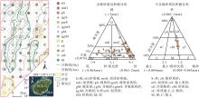
Fig. 1
Location of the study area and sediment types at sampling stations"

Fig. 1
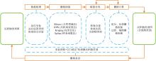
Fig. 2
Workflow for mapping seabed sediment types"
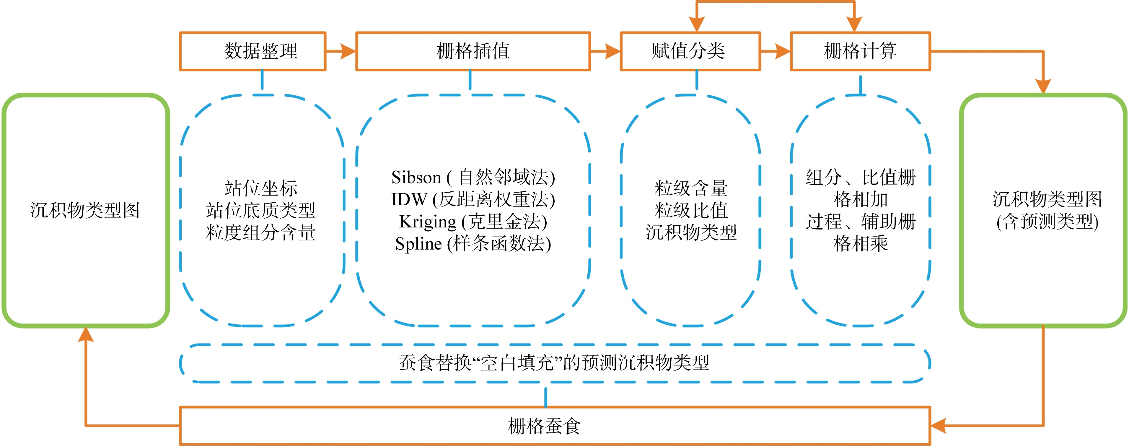
Fig. 2
Tab. 1
Principle and characteristics of interpolation methods for sediment type mapping"
| 插值方法 | 主要原理 | 特点 |
|---|---|---|
| Sibson (自然邻域法) | 取样站位构成邻近原始Voronoi多边形, 插值点周围创建新Voronoi多边形, 基于新的多边形与原始多边形之间的重叠比例作权重进行插值 | a)仅利用插值点周围的取样站位数据; 插值均在局部取样站位数据区间内; 插值表面平滑 b)图件界线合理、圆滑 |
| IDW (反距离权重法) | 以反距离函数为权重, 使用一组站位数据的线性权重组合来确定插值 | a)主要依赖于反距离的幂值, 幂值越高表面越不平滑, 反之表面更加平滑, 最佳幂值不易确定 b)图件界线相对合理, 但容易产生“孤岛” |
| Kriging (克里金法) | 普通克里金是一个线性估计系统, 适用于任何满足各向同性假设的固有平稳随机场 | a)根据地统计分析, 创建变异函数和协方差函数, 估算数据的空间自相关, 最后进行插值 b)插值取决于变量的自相关性强弱, 强相关性插值结果平滑, 弱相关性插值结果有可能呈现“锯齿状” c)绘制沉积物类型图需要兼顾砾含量、砂含量、砂/泥比值、粉砂/黏土比值、含砾界线划分等空间相关性, 难以找到合适的插值参数 |
| Spline (样条函数法) | 利用最小化表面总曲率的数学函数来插值 | a)插值表面平滑、平缓变化 b)插值范围易超出合理范围, 难以找到合适的插值参数 |
Tab. 1
Tab. 2
Reclassification of clastic sediment components and assignment of sediment types"
| 含砾碎屑沉积物分类 | 不含砾碎屑沉积物分类 | ||||||||||
|---|---|---|---|---|---|---|---|---|---|---|---|
| 砾 组分含量/% | 砂/泥 比值 | 砾组分含量 赋值 | 砂/泥比值 赋值 | 沉积物类型 赋值 | 沉积物 类型 | 砂 组分含量/% | 粉砂/黏土 比值 | 砂组分含量 赋值 | 粉砂/黏土比值 赋值 | 沉积物类型 赋值 | 沉积物 类型 |
| 1 | 2 | 3 | 4 | 3+4 | 5 | 6 | 7 | 8 | 9 | 8+9 | 10 |
| ≥80 | 10 | 10 | 砾 | ≥90 | 60 | 60 | 砂 | ||||
| 30~80 | ≥9 | 20 | 1 | 21 | 砂质砾 | 50~90 | ≥2 | 70 | 5 | 75 | 粉砂质砂 |
| 30~80 | 1~9 | 20 | 2 | 22 | 泥质砂质砾 | 50~90 | 0.5~2 | 70 | 6 | 76 | 泥质砂 |
| 30~80 | <1 | 20 | 3 | 23 | 泥质砾 | 50~90 | <0.5 | 70 | 7 | 77 | 黏土质砂 |
| 5~30 | ≥9 | 30 | 1 | 31 | 砾质砂 | 10~50 | ≥2 | 80 | 5 | 85 | 砂质粉砂 |
| 5~30 | 1~9 | 30 | 2 | 32 | 砾质泥质砂 | 10~50 | 0.5~2 | 80 | 6 | 86 | 砂质泥 |
| 5~30 | <1 | 30 | 3 | 33 | 砾质泥 | 10~50 | <0.5 | 80 | 7 | 87 | 砂质黏土 |
| 0.01~5 | ≥9 | 40 | 1 | 41 | 含砾砂 | <10 | ≥2 | 90 | 5 | 95 | 粉砂 |
| 0.01~5 | 1~9 | 40 | 2 | 42 | 含砾泥质砂 | <10 | 0.5~2 | 90 | 6 | 96 | 泥 |
| 0.01~5 | <1 | 40 | 3 | 43 | 含砾泥 | <10 | <0.5 | 90 | 7 | 97 | 黏土 |
| <0.01 | ≥9 | 50 | 1 | 51 | 砂 | ||||||
| <0.01 | 1~9 | 50 | 2 | 52 | 泥质砂 | ||||||
| <0.01 | 1/9~1 | 50 | 3 | 53 | 砂质泥 | ||||||
| <0.01 | <1/9 | 50 | 4 | 54 | 泥 | ||||||
Tab. 2
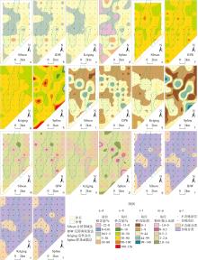
Fig. 3
Comparison of four spatial interpolation methods"
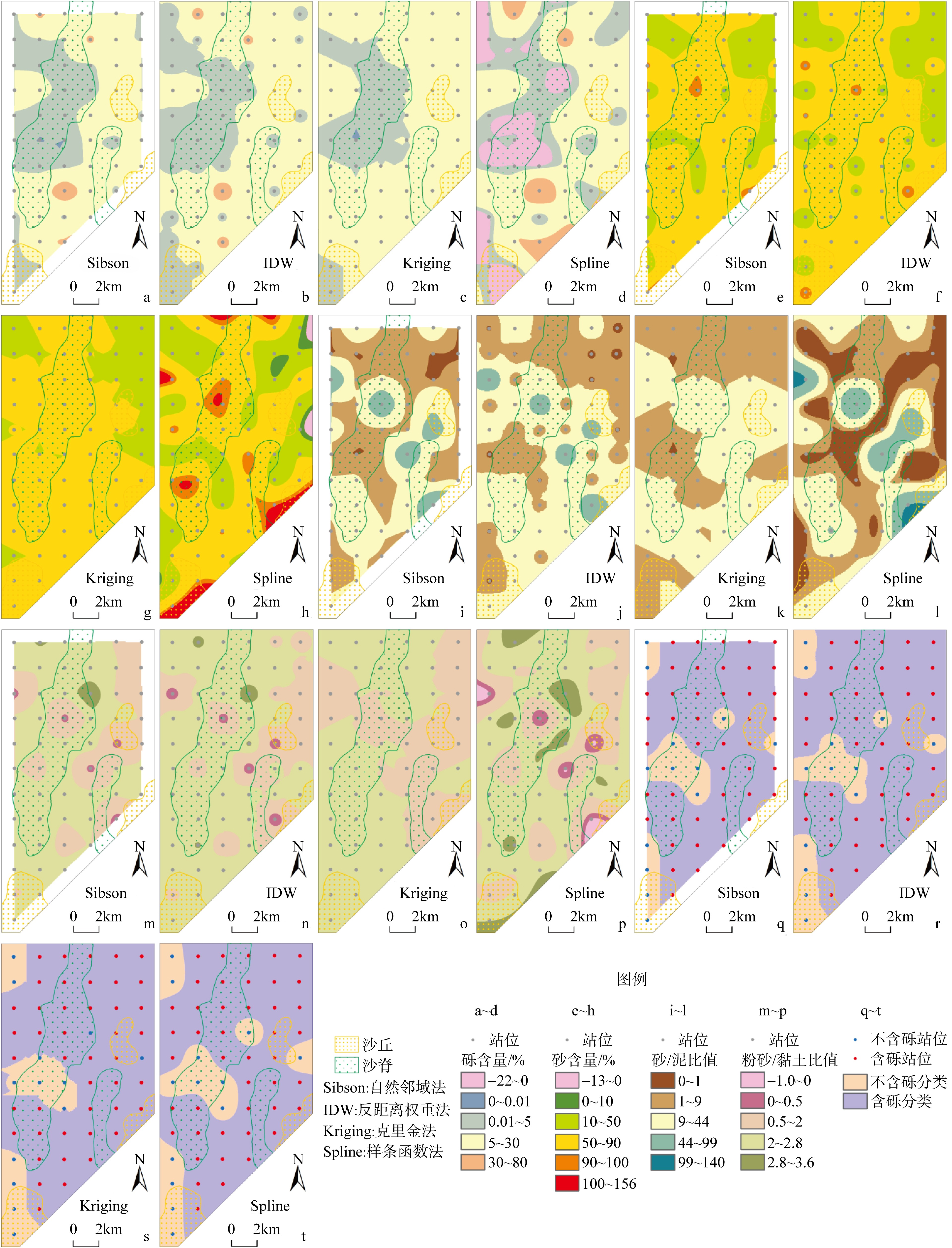
Fig. 3
Tab. 3
Comparison of spatial interpolation results with sampling station data"
| 空间插值方法 | 砾含量/% | 砂含量/% | 砂/泥比值 | 粉砂/黏土比值 |
|---|---|---|---|---|
| 自然邻域法 | 1.03~50.13 | 10.18~98.11 | 0.15~97.58 | 0.02~3.48 |
| 反距离权重法 | 0~50.95 | 9.64~98.31 | 0.12~98.27 | 0~3.51 |
| 克里金法 | 0~26.88 | 23.57~87.04 | 0.84~43.91 | 1.09~2.80 |
| 样条函数法 | −21.64~51.37 | −12.47~155.23 | −35.47~139.47 | −0.94~3.52 |
| 取样站位 | 0~51.00 | 9.60~98.36 | 0.11~45.28 | 1.45~3.51 |
Tab. 3
Fig. 4
Comparison of sediment types drawn using three mapping methods"

Fig. 4
Tab. 4
Comparison of un-eroded and eroded sediment type maps"
| 空间插值方法 | 图斑面积占比/% | 图斑数量/块 | 沉积物类型数量/个 | 未蚕食预测新增沉积物类型 | |||||||||
|---|---|---|---|---|---|---|---|---|---|---|---|---|---|
| 未蚕食 | 蚕食后 | 未蚕食 | 蚕食后 | 未蚕食 | 蚕食后 | ||||||||
| 站位 控制 | 预测 | 站位 控制 | 站位 控制 | 预测 | 合计 | 站位 控制 | 站位 控制 | 预测 | 预测 新增 | 合计 | 站位 控制 | ||
| 自然邻域法 | 85.05 | 14.95 | 100 | 40 | 86 | 126 | 38 | 13 | 12 | 1 | 14 | 13 | 泥质砂 |
| 反距离权重法 | 87.89 | 12.11 | 100 | 47 | 52 | 99 | 46 | 13 | 10 | 1 | 14 | 13 | 泥质砂 |
Tab. 4
Tab. 5
Comparison of Kappa coefficients"
| 图件 | 4a | 4b | 4c | 4d | 4e | 4f | 4g | 4h | 4i | 4j | 4k | 4l |
|---|---|---|---|---|---|---|---|---|---|---|---|---|
| 4a | 1 | |||||||||||
| 4b | 0.81 | 1 | ||||||||||
| 4c | 0.67 | 0.63 | 1 | |||||||||
| 4d | 0.61 | 0.71 | 0.84 | 1 | ||||||||
| 4e | 0.48 | 0.42 | 0.28 | 0.28 | 1 | |||||||
| 4f | 0.44 | 0.51 | 0.3 | 0.33 | 0.83 | 1 | ||||||
| 4g | 0.29 | 0.26 | 0.25 | 0.23 | 0.64 | 0.56 | 1 | |||||
| 4h | 0.27 | 0.29 | 0.22 | 0.26 | 0.58 | 0.62 | 0.87 | 1 | ||||
| 4i | 0.52 | 0.47 | 0.39 | 0.37 | 0.62 | 0.56 | 0.45 | 0.42 | 1 | |||
| 4j | 0.44 | 0.49 | 0.35 | 0.38 | 0.49 | 0.55 | 0.35 | 0.38 | 0.66 | 1 | ||
| 4k | 0.42 | 0.4 | 0.38 | 0.37 | 0.53 | 0.5 | 0.52 | 0.47 | 0.72 | 0.53 | 1 | |
| 4l | 0.45 | 0.49 | 0.42 | 0.45 | 0.53 | 0.58 | 0.48 | 0.48 | 0.65 | 0.64 | 0.83 | 1 |
Tab. 5
Tab. 6
Advantage analysis of mapping methods"
| 制图方法 | 插值变量 | 含砾与不含砾分类 | 图面效果 | 实际采样点对比 | 蚕食 | 制图效率 |
|---|---|---|---|---|---|---|
| 推荐方法—— 自然邻域赋值法 | 组分及比值 (无须对组分进行闭合约束) | 以取样站位等分 | 孤岛少、分区较 圆滑、图面美观 | 一致 | 蚕食 或部分蚕食 | 高 |
| 反距离权重赋值法 | 组分及比值 (无须对组分进行闭合约束) | 以取样站位等分 | 孤岛较多 | 一致 | 蚕食 或部分蚕食 | 高 |
| 闭合组分法 | 组分 (一般需要对组分进行闭合约束) | 以含砾0.01%划分, 弱化不含砾分类 | 孤岛多、尤其是不 含砾分类易呈孤岛 | 一致 | 无 | 高 |
| 勾绘法 | 主观勾绘 | 以取样站位平均划分 或其他方法确定 | 因人而异 | 一致 | 无 | 低 |
Tab. 6
Fig. 5
Sediment type shading map"

Fig. 5
| [1] |
曹兵, 马越, 王长海, 2011. 海洋表层沉积物类型分布图绘制方法研究[J]. 海洋通报, 30(6): 615-618.
|
|
|
|
| [2] |
冯永财, 郝连成, 胡延斌, 等, 2024. 渤海湾曹妃甸海域沉积物粒度分布特征及运移趋势分析[J]. 海洋地质前沿, 40(11): 57-69.
|
|
|
|
| [3] |
郝连成, 远继东, 郑立龙, 等, 2022. 湛江湾海域表层沉积物粒度特征及沉积环境[J]. 海洋地质前沿, 38(8): 1-10.
|
|
|
|
| [4] |
何起祥, 李绍全, 刘健, 2002. 海洋碎屑沉积物的分类[J]. 海洋地质与第四纪地质, 22(1): 115-121.
|
|
|
|
| [5] |
孔祥淮, 徐庆建, 徐刚, 等, 2014. 海底沉积物类型判别及其平面分布图绘制[J]. 海洋地质前沿, 30(5): 9-14.
|
|
|
|
| [6] |
李春轩, 罗毅, 包安明, 等, 2012. 基于对数比转换的成分数据空间插值研究[J]. 中国农业科学, 45(4): 648-655.
doi: 10.3864/j.issn.0578-1752.2012.04.005 |
|
|
|
| [7] |
刘付程, 彭俊, 2015. 基于对数比转换方法的沉积物粒级组分空间预测与底质类型制图[J]. 海洋科学, 39(6): 122-128.
|
|
|
|
| [8] |
刘付程, 彭俊, 张瑞, 等, 2011. 一种近海底质类型图生成的非参数方法[J]. 海洋通报, 30(5): 551-556.
|
|
|
|
| [9] |
梅西, 李学杰, 密蓓蓓, 等, 2020. 中国海域表层沉积物分布规律及沉积分异模式[J]. 中国地质, 47(5): 1447-1462.
|
|
|
|
| [10] |
缪卫东, 李世杰, 冯金顺, 等, 2016. 长江三角洲NB5孔第四纪地层划分及环境变化信息[J]. 中国地质, 43(6): 2022-2035.
|
|
|
|
| [11] |
覃茂刚, 龙根元, 李海云, 等, 2023. 基于K-means聚类层次分析模型的中沙环礁地质环境稳定性定量分析[J]. 热带海洋学报, 42(2): 113-123.
|
|
|
|
| [12] |
孙思佳, 刘付程, 周艺, 等, 2023. 沉积物粒度组分空间预测的地理加权回归残余Kriging方法[J]. 海洋湖沼通报, 45(6): 34-42.
doi: 10.13984/j.cnki.cn37-1141.2023.06.005 |
|
|
|
| [13] |
喜扬洋, 王日明, 冯炳斌, 等, 2022. 北海银滩响应台风作用的动力地貌过程[J]. 热带海洋学报, 41(4): 97-104.
doi: 10.11978/2021097 |
|
doi: 10.11978/2021097 |
|
| [14] |
许冬, 葛倩, 韩喜彬, 等, 2022. 海洋沉积源-汇过程的驱动因素: 以北部湾为例[J]. 海洋学研究, 40(3): 17-32.
|
|
doi: 10.3969-j.issn.1001-909X.2022.03.003 |
|
| [15] |
杨康, 张永战, 2007. 基于栅格叠合的沉积物底质图生成方法[J]. 第四纪研究, 27(5): 889-895.
|
|
|
|
| [16] |
殷志强, 秦小光, 李玉梅, 等, 2008. 源区距离对黄土粒度多组分分布特征的影响[J]. 中国地质, 35(5): 1037-1044.
|
|
|
|
| [17] |
doi: 10.1177/001316446002000104 |
| [18] |
doi: 10.1080/00288306.1970.10418211 |
| [19] |
doi: 10.1016/0898-1221(82)90009-8 |
| [20] |
doi: 10.31035/cg2018062 |
| [21] |
doi: 10.1016/0025-3227(94)90029-9 |
| [22] |
doi: 10.1007/BF01031292 |
| [23] |
|
| [24] |
|
| [25] |
doi: 10.1016/0898-1221(88)90255-6 |
| [26] |
|
| [27] |
|
| [28] |
|
| [29] |
|
| [30] |
doi: 10.1007/BF02850664 |
| [31] |
|
| [32] |
|
| [33] |
|
| [1] | SHAO Changgao, YAN Bin, CHEN Qiu. Clustering algorithm of irregular marine geological sampling data based on spatial interpolation [J]. Journal of Tropical Oceanography, 2024, 43(2): 166-172. |
|
||