
Journal of Tropical Oceanography >
The b-value mapping in the Kyushu subduction zone and its tectonic significance
Received date: 2020-03-17
Request revised date: 2020-04-20
Online published: 2020-04-24
Supported by
Natural Science Foundation of Guangdong Province(2017A030311015)
National Natural Science Foundation of China(U1701641)
National Natural Science Foundation of China(41576046)
Key Special Project for Introduced Talents Team of Southern Marine Science and Engineering Guangdong Laboratory (Guangzhou)(GML2019ZD0204)
Open Fund Project of the Key Laboratory of Ocean and Marginal Sea Geology, Chinese Academy of Sciences(OMG18-03)
Copyright
The Kyushu subduction zone is a unique region on the convergent boundary between the Philippine Sea Plate and Eurasian Plate. The zone is an ideal place to study plate interaction within the subduction zone. To understand the stress state and interaction characteristics between plates in the subduction zone in this region, we use 97251 earthquake events beneath 20-km depth in the region to delineate the upper surface of the subduction plate and the section of the vertical trench direction by detailing b-value. We found that the b-value in this area has significant spatial variation, which gradually increases from the northeast to the southwest along the Nankai Trough and Ryukyu Trench. There is also a significant low b-value zone on the subducted Kyushu-Palau Ridge. It is inferred from the negative correlation between the b-value and stress that the ridge has entered the subduction zone, and that the Shikoku Basin ocean crust on the northeast side of the ridge is strongly coupled with the overlying slab of the subduction zone, while the coupling effect of the convergent plates in the subduction zone on the southwest side of the ridge is relatively weak. We believe that the formation times and convergence rates of subduction ocean crusts on both sides of the Kyushu-Palau Ridge played important roles. For the Kyushu-Palau Ridge, the low b-value zone in the shallow part of the subduction zone is mainly due to enhanced coupling between the towering ridge and overlying plate. With the increase of the subduction depth and the steepening of the inclination of the subducting plate, a plate tear along the ridge may occur, thereby releasing the compression-shear stress between the ridge and overlying plate, and causing the degree of coupling to be greatly weakened.
Key words: Kyushu subduction zone; b-value; plate interaction; ridge subduction
LI Yunjie , ZHOU Pengxiang , XIA Shaohong , WAN Kuiyuan , SUN Jinlong . The b-value mapping in the Kyushu subduction zone and its tectonic significance[J]. Journal of Tropical Oceanography, 2021 , 40(1) : 122 -132 . DOI: 10.11978/2020031
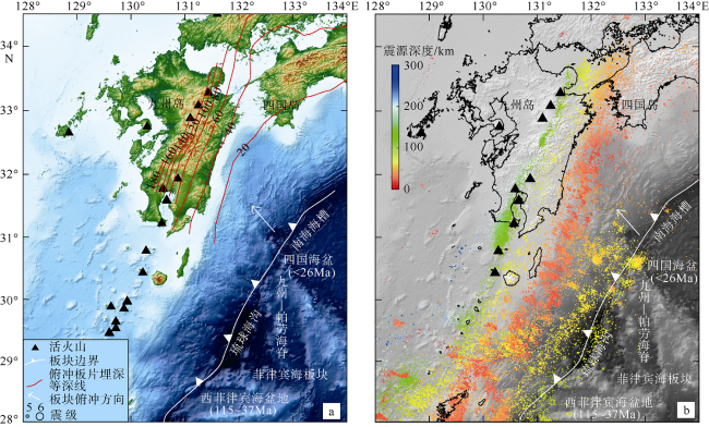
图1 研究区地形与构造概况图(a)和本研究使用的地震震源分布图(b)俯冲的菲律宾海板块上边界埋深等深线在图a中用间隔为20km的红色曲线表示, 数据来源于Wang等(2004); 图b中彩色圆圈/点为地震震源分布, 大小均以震级乘以同个系数成图, 图例中只列出5级和6级作为地震大小参考 Fig. 1 (a) Overview of the tectonic of the study region. (b) Distribution map of seismic source locations (colored circles/dots) used in this study |
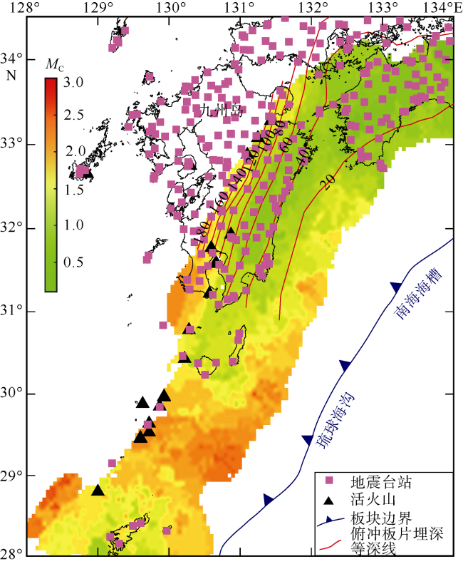
图2 最小完整性震级(MC)的分布特征俯冲的菲律宾海板块上边界埋深等深线用间隔为20km的红色曲线表示, 数据来源于Wang等(2004) Fig. 2 Distribution of Magnitude of Completeness (MC). Depth contours of the upper boundary of the subducting Philippine Sea slab are shown in red with an interval of 20 km (Wang et al, 2004) |
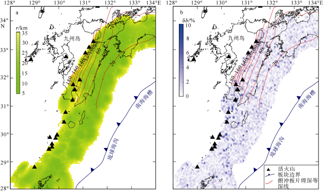
图4 b值成像的扫描半径r(a)和b值的标准误差δb(b)分布特征俯冲的菲律宾海板块上边界埋深等深线用间隔为20km的红色曲线表示, 数据来源于Wang等(2004) Fig. 4 (a) Distribution of sampling radius for mapping b-value. (b) Distribution of standard errors of b-value. Depth contours of the upper boundary of the subducting Philippine Sea slab are shown in red with an interval of 20 km (Wang et al, 2004) |
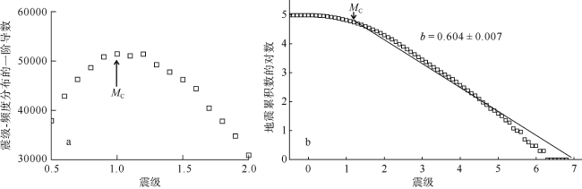
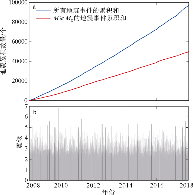
图5 地震随时间累积曲线图(a)和地震(M≥0)的震级-时间分布图(b)Fig. 5 (a) Cumulative curve of earthquakes with time, and (b) distribution of magnitude-time of earthquake(M≥0) |
图6 由包含余震的地震数据(a)和删除余震后的地震数据(b)计算得到的b值分布特征俯冲的菲律宾海板块上边界埋深等深线用间隔为20km的红色曲线表示, 数据来源于Wang等(2004) Fig. 6 (a) Distribution characteristics of b-value calculated from data that contain aftershocks, and (b) distribution characteristics of b-value calculated from data that contain no aftershocks |
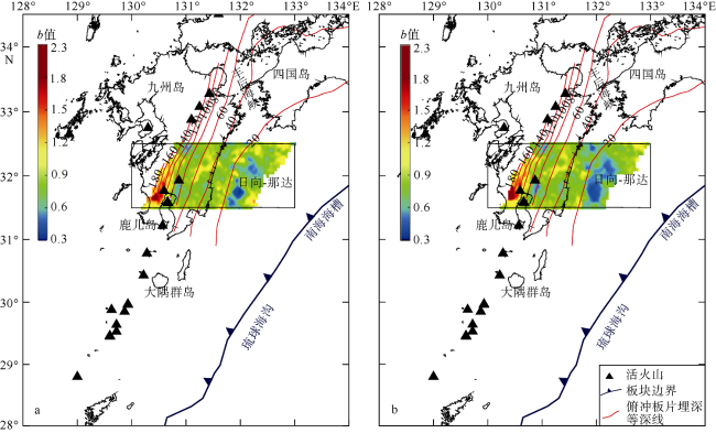
图7 菲律宾海板块上表面b值分布特征俯冲的菲律宾海板块上边界埋深等深线用间隔为20km的红色曲线表示, 数据来源于Wang等(2004) Fig. 7 Distributive characteristics of b-value on both sides of Kyushu-Palau Ridge |
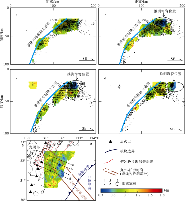
图8 垂直于海沟的剖面b值分布特征(a—d)及剖面位置示意图(e)图a—d中的地震大小均以震级乘以同个系数成图, 图例中只列出4级、5级和6级作为地震大小参考; 图e中俯冲的菲律宾海板块上边界埋深等深线用间隔为20km的红色曲线表示, 数据来源于Wang等(2004) Fig. 8 Distribution of b-value along the cross-sections of a, b, c, and d of the Kyushu-Palau Ridge profile |
表1 九州-帕劳海脊两侧的洋壳特征Tab. 1 Regional characteristics of the north and south sides of the Kyushu subduction zone |
| 海脊东北侧 | 海脊西南侧 | |
|---|---|---|
| 地震b值 | 0.71 | 0.76 |
| 板块年龄 | ≤26Ma | 115~37Ma |
| 板块俯冲倾角 | 较缓 | 较陡 |
| 板块俯冲速度 | 3.8~5.5cm·a-1 | 约2cm·a-1 |
| 板块俯冲方向 | 北西向 | 西向 |
| 板块滑差率 | 5~6cm·a-1 | <5cm·a-1 |
| 海底热流值 | 120~200mW·m-2 | 40~80mW·m-2 |
| 俯冲板间联结程度 | 较强 | 较弱 |
| [1] |
陈凌, 刘杰, 陈颙, 等, 1998. 地震活动性分析中余震的删除[J]. 地球物理学报, 41(S1):244-252.
|
| [2] |
韩立波, 蒋长胜, 李艳娥, 等, 2012. 用于地震可预测性CSEP计划的南北地震带地区地震最小完整性震级MC研究[J]. 地震, 32(1):17-27.
|
| [3] |
李付成, 孙珍, 张江阳, 2016. 海山俯冲过程中的变形特征——物理模拟和数值模拟证据[J]. 热带海洋学报, 35(1):31-37.
|
| [4] |
刘雁冰, 裴顺平, 2017. 汶川地震前后b值的时空变化及构造意义[J]. 地球物理学报, 60(6):2104-2112.
|
| [5] |
刘再峰, 詹文欢, 张志强, 2007. 台湾-吕宋岛双火山弧的构造意义[J]. 大地构造与成矿学, 31(2):145-150.
|
| [6] |
盛菊琴, 马禾青, 任学梅, 等, 2007. 基于区域地震活动频次对比的余震删除方法[J]. 地震, 27(1):85-94.
|
| [7] |
徐纪人, 赵志新, 河野芳辉, 等, 2003. 日本南海海槽地震区域应力场及其板块构造动力学特征[J]. 地球物理学报, 46(4):488-494.
|
| [8] |
徐伟进, 吴健, 2017. 余震时空丛集对概率地震危险性分析的影响[J]. 地球物理学报, 60(8):3110-3118.
|
| [9] |
张建中, 宋良玉, 1981. 地震b值的估计方法及其标准误差——应用蒙特卡罗方法估计b值精度[J]. 地震学报, 3(3):292-301.
|
| [10] |
|
| [11] |
|
| [12] |
|
| [13] |
|
| [14] |
|
| [15] |
|
| [16] |
|
| [17] |
|
| [18] |
|
| [19] |
|
| [20] |
|
| [21] |
|
| [22] |
|
| [23] |
|
| [24] |
|
| [25] |
|
| [26] |
|
| [27] |
|
| [28] |
|
| [29] |
|
| [30] |
|
| [31] |
|
| [32] |
|
| [33] |
|
| [34] |
|
| [35] |
|
| [36] |
|
| [37] |
|
| [38] |
|
| [39] |
|
| [40] |
|
| [41] |
|
| [42] |
|
| [43] |
|
| [44] |
|
| [45] |
|
| [46] |
|
/
| 〈 |
|
〉 |

