Marine Geophysics

Characteristics of gravity anomaly and crustal thickness of three largest oceanic plateaus

  • LUO Yiming , 1, 2, 3, 4, 6 ,
  • ZHANG Jinchang 1, 2, 3 ,
  • LIN Jian , 1, 2, 3, 5, 6
Expand
  • 1.Key Laboratory of Ocean and Marginal Sea Geology, South China Sea Institute of Oceanology, Innovation Academy of South China Sea Ecology and Environmental Engineering, Chinese Academy of Sciences, Guangzhou 510301, China
  • 2.China-Pakistan Joint Research Center on Earth Sciences, Guangzhou 510301, China
  • 3.Southern Marine Science and Engineering Guangdong Laboratory (Guangzhou), Guangzhou 511458, China
  • 4.University of Chinese Academy of Sciences, Beijing 100049, China
  • 5.Department of Geology and Geophysics, Woods Hole Oceanographic Institution, Woods Hole, MA 02543, USA
  • 6.Department of Ocean Science and Engineering, Southern University of Science and Technology, Shenzhen 518055, China
LIN Jian. E-mail:

Received date: 2019-11-13

  Request revised date: 2019-12-25

  Online published: 2020-07-27

Supported by

Foundation item: National Key Research and Development Program of China(2018YFC0309800)

Key Special Project for Introduced Talents Team of Southern Marine Science and Engineering Guangdong Laboratory(Guangzhou)(GML2019ZD0205)

National Natural Science Foundation of China(41776058)

National Natural Science Foundation of China(41890813)

National Natural Science Foundation of China(91628301)

National Natural Science Foundation of China(U1606401)

National Natural Science Foundation of China(41706056)

National Natural Science Foundation of China(41976066)

Natural Science Foundation of Guangdong Province(2017A030313243)

Chinese Academy of Sciences Project(QYZDY-SSW-DQC005)

Chinese Academy of Sciences Project(133244KYSB20180029)

Chinese Academy of Sciences Project(Y4SL021001)

Copyright

Copyright reserved © 2020. Office of Acta Agronomica Sinica All articles published represent the opinions of the authors, and do not reflect the official policy of the Chinese Medical Association or the Editorial Board, unless this is clearly specified.

Abstract

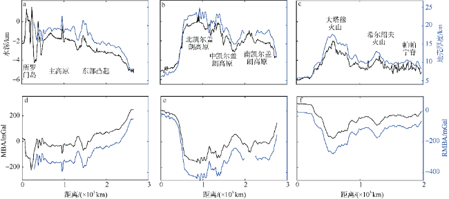
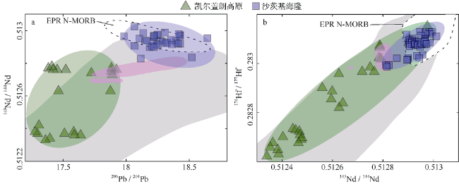
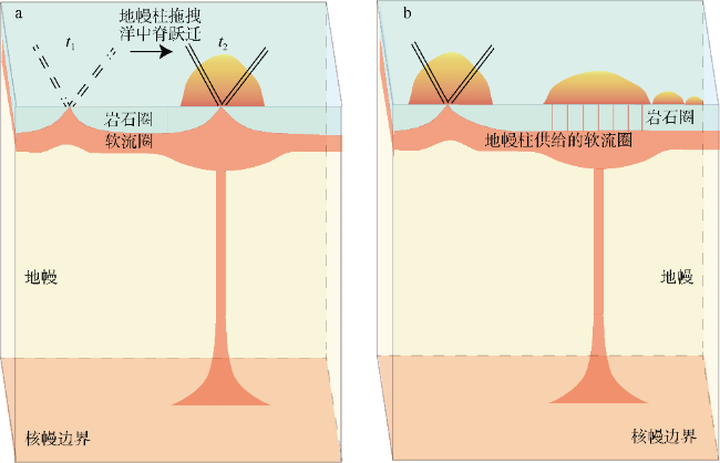
The Ontong Java Plateau, Kerguelen Plateau, and Shatsky Rise are the three largest oceanic plateaus on Earth, exhibiting voluminous magmatism with areas of 1.90×10⁶, 1.25×10⁶, and 0.53×10⁶ km2, respectively. In this study, we conducted a detailed comparative analysis of bathymetry, residual mantle Bouguer anomaly (RMBA), and gravity-derived relative crustal thickness of the three plateaus, correlating results with geological and geochemical constraints. Relative to adjacent normal seafloors, the Ontong Java Plateau is elevated by 4.3 km; the Kerguelen Plateau, by 5 km; and the Shatsky Rise, by 4 km. The corresponding peak-to-trough amplitudes in RMBA are about 250, 330, and 200 mGal, while the relative crustal thickness variations are of 11, 13, and 9 km, respectively, implying that the magma output forming these three oceanic plateaus is far more than that generated by a normal mid-ocean ridge. Moreover, all three plateaus were formed near mid-ocean ridge or ridge triple junction settings. Isotopic analyses of Nd, Pb, and Hf reveal that the Ontong Java Plateau is characterized by ocean island basalts (OIB); most of the Kerguelen Plateau is predominantly OIB, but is mixed with some mid-ocean ridge basalts (MORB); and most of the Shatsky Rise volcanism shows East Pacific Rise-type MORB, with a few exceptions of OIB-like components. These features imply that these oceanic plateaus were probably formed by “plume-ridge interaction”. Two models are proposed herein: (1) the peripheral mid-ocean ridge is dragged onto the top of the mantle plume, and/or (2) the asthenosphere is fed by plume material nearby, resulting in melting anomalies and the resultant thickened crust along the mid-ocean ridge.

Cite this article

LUO Yiming , ZHANG Jinchang , LIN Jian . Characteristics of gravity anomaly and crustal thickness of three largest oceanic plateaus[J]. Journal of Tropical Oceanography, 2020 , 39(4) : 100 -115 . DOI: 10.11978/2019116

*感谢“中国-巴基斯坦地球科学研究中心项目”对本项研究工作的支持; 感谢朱健博士、王婷婷博士以及中国科学院南海海洋研究所深海地球动力学学科组成员对本文的讨论与帮助; 感谢审稿专家提出的修改意见。
火山作用将地球内部的岩浆输送到岩石圈, 塑造了地表的构造形态。地球上的火山作用主要分布在离散型板块边界(裂谷与大洋中脊)、汇聚型板块边界(岛弧与弧后)以及与热点有关的地区。强烈的热点火山作用喷出大量岩浆到地表, 形成面积超过105km2、地壳异常厚的大火成岩省(Large Igneous Province, LIP; 图1)(Coffin et al, 1994)。洋底高原(oceanic plateau)位于深海盆地, 一般高几千米, 呈宽广的穹顶状, 与大陆溢流玄武岩(continental flood basalts)、火山型被动陆缘(volcanic passive continental margin)同属于大火成岩省。早期对大火成岩省的研究主要是大陆溢流玄武岩(Macdougall, 1988), 因其位于陆地而便于调查和获取岩石样品, 如哥伦比亚河溢流玄武岩省(Columbia River flood basalt province)(Carlson, 1984)和德干玄武岩(Deccan Traps)(Cox et al, 1985; 徐义刚, 2002)等(图1)。随着现代海洋科技的发展, 国际科学家开始研究位于海底的大火成岩省, 包括: 1) 火山型被动陆缘(Mahoney et al, 1997; Geoffroy, 2005), 如红海火山型陆缘(Red Sea volcanic margin)(Wolfenden et al, 2005)、东印度火山型张裂边缘(eastern India volcanic rifted margin) (Subrahmanyam et al, 2006)等; 2) 洋底高原, 如翁通爪哇高原(Ontong Java)(Korenaga, 2005)、凯尔盖朗高原(Kerguelen Plateau)(Mahoney et al, 1995)和沙茨基海隆(Shatsky Rise)(Sager et al, 2013)等。目前对大火成岩省的研究已取得了一系列进展, 包括地质学、地质年代学、地球物理与地球化学等多学科研究。大火成岩省代表着长期大规模的火山活动, 是地幔异常熔融的结果, 然而其具体的形成机制至今依然存在争议。
图1 全球地形图

地形数据来自于Sandwell等(2014)。黄线圈定区为全球三大洋底高原及热点成因的其他火山体, 红线圈定区为2个大陆溢流玄武岩的例子

Fig. 1 Map of global topography.

Topography data are from Sandwell et al (2014). Yellow lines outline the three largest oceanic plateaus and other volcanic edifices associated with hotspot volcanism. Red contours and lines delineate examples of continental flood basalts

洋底高原作为海洋中最显著的大火成岩省, 其综合研究对解决大火成岩省的形成机制问题具有关键启示意义。目前有两种主流的形成机制假说: 一种认为大火成岩省起源于深部地幔上涌, 即“地幔柱”假说(Richards et al, 1989; Coffin et al, 1994; 陆鹿 等, 2016; 宋晓晓 等, 2016); 另一种为“板块”假说, 提出大火成岩省并非起源于深部地幔, 而是与板块构造有关的浅部地幔过程所导致(Anderson, 2005; Foulger, 2010)。这两种假说各自具有强有力的证据支持, 包括地形隆起、壳幔地震成像、岩浆作用的时空分布、火山岩的地球化学特征及其揭示的地幔源岩温度、岩浆量等(Foulger, 2010)。
本文主要研究地球上最大的三个洋底高原——翁通爪哇高原、凯尔盖朗高原与沙茨基海隆。通过定量计算全球三大洋底高原的地幔布格重力异常(mantle Bouguer anomaly, MBA)、剩余地幔布格重力异常(residual mantle Bouguer anomaly, RMBA)与重力反演的相对地壳厚度, 结合海洋地质与地球化学等特征, 详细对比分析了三大洋底高原的共性与差异, 试图验证洋底高原的形成机制假说, 从而有助于进一步了解从地幔至岩石圈大规模岩浆作用的地球动力学过程。

1 地质背景

1.1 翁通爪哇高原

翁通爪哇高原位于西南太平洋赤道附近(图1), 北侧为东马里亚纳盆地(East Mariana Basin), 西侧为莱拉盆地(Lyra Basin), 东侧为瑙鲁盆地(Nauru Basin), 东南部夹一个斯图尔特盆地(Stewart Basin), 西南侧与所罗门岛(Solomon Islands)相连。翁通爪哇高原由主高原(Main Plateau)与东部凸起(Eastern Salient)组成(图2), 是全球最大的洋底高原, 面积约1.90×10⁶km2, 水深约1~3km, 平均地壳厚约30km, 地壳最厚可达38km(Neal et al, 1997; Ridley et al, 2010)。来自大洋钻探计划(Ocean Drilling Program, ODP)、深海钻探计划(Deep Sea Drilling Project, DSDP)以及位于高原南缘的马莱塔岛(Malaita Island)基底的玄武岩40Ar/39Ar定年得出, 约在122Ma时期, 大规模火山短期内快速喷发形成翁通爪哇高原, 随后在90Ma发生一个较小的后期火山作用(Mahoney et al, 1993)。翁通爪哇高原的基底岩石成分为拉斑玄武岩, 部分熔融程度很高, 与冰岛玄武岩相似(Mahoney et al, 1993)。Taylor(2006)根据年龄与岩石组分, 提出翁通爪哇、马尼希基(Manihiki)、希古朗基(Hikurangi)这3个高原曾为一体, 随后由于海底扩张, 三者逐渐被分离至现今位置。
图2 翁通爪哇高原的地质概况

a. 水深; b. 自由空气重力异常; c. 地壳年龄; d. 沉积物厚度。图c、d中白色区域为数据空白区

Fig. 2 Geological setting of the Ontong Java Plateau:

(a) bathymetry, (b) free-air gravity anomaly, (c) crustal age, and (d) sediment thickness. White areas in (c) and (d) denote areas lacking data

1.2 凯尔盖朗高原

凯尔盖朗高原位于印度洋南部的南极洲板块上(图1), 距离东南印度洋脊(Southeastern Indian Ridge)约1000km, 其东侧是澳大利亚-南极洲盆地(Australia-Antarctica Basin)与拉布湾盆地(Labuan Basin), 西侧为恩德比盆地(Enderby Basin), 由南、中、北凯尔盖朗高原(Southern, Central, Northern Kerguelen Plateau)和埃朗浅滩(Elan Bank)组成(图3)。作为全球第二大洋底高原, 凯尔盖朗高原水深1~3km, 呈西北—东南向, 长约2300km, 宽约500km, 面积约1.25×10⁶km2。凯尔盖朗热点是全球岩浆活动时间最长的热点之一, 岩浆喷发持续了约120Ma(Coffin et al, 2002)。自120—100Ma以来, 大量岩浆喷发形成了南凯尔盖朗高原、埃朗浅滩以及中凯尔盖朗高原(Coffin et al, 2002)。随后, 减弱的岩浆作用沿着印度板块与澳大利亚板块边界形成了热点轨迹——东经九十度海岭(Ninetyeast Ridge) (Bredow and Steinberger, 2018)。板块重构结果表明, 布罗肯海岭(Broken Ridge)与中凯尔盖朗高原是同一整体, 自40Ma以来东南印度洋脊的扩张将布罗肯海岭从凯尔盖朗高原分裂出来(Frey et al, 2000)。同一时期, 热点岩浆作用形成了北凯尔盖朗高原。其中, 北凯尔盖朗高原的凯尔盖朗群岛(Kerguelen Archipelago)、中凯尔盖朗高原的赫德岛(Heard Island)与麦当劳岛(McDonald Island)是高原上露出水面的岛屿, 至今仍存在火山活动。
图3 凯尔盖朗高原的地质概况

a. 水深; b. 自由空气重力异常; c. 地壳年龄; d. 沉积物厚度。图c、d中白色区域为数据空白区

Fig. 3 Same as Fig. 2, except for the Kerguelen Plateau

1.3 沙茨基海隆

沙茨基海隆位于西北太平洋, 日本以东1500km(图1), 东侧为墨卡托盆地(Mercator Basin), 西侧为西北太平洋盆地(Northwest Pacific Basin), 水深约3~4km, 面积约0.53×10⁶km2(Zhang et al, 2016), 是全球第三大洋底高原。由自西南向北东方向排列的大塔穆火山(Tamu Massif)、奥里火山(Ori Massif)、希尔绍夫火山(Shirshov Massif)与帕帕宁脊(Papanin Ridge)组成(图4), 年龄逐渐变年轻(Nakanishi et al, 1999), 其中大塔穆火山是全球最大的单体火山, 面积约0.32×10⁶km2(Sager et al, 2013)。沙茨基海隆形成于晚侏罗—早白垩纪(147—121Ma), 在沙茨基海隆上钻取的玄武岩样品年龄与周围地壳古地磁年龄一致, 表明沙茨基海隆在洋中脊三联点(由太平洋、伊泽奈崎与法拉龙板块构成)附近形成(Nakanishi et al, 1999; Mahoney et al, 2005)。此外, 最新地磁研究在大塔穆火山发现了线性的磁异常(磁异常条带), 揭示了沙茨基海隆形成于海底扩张(Huang et al, 2018; Sager et al, 2019)。由于沙茨基海隆随着伊泽奈崎板块(Izanagi Plate)与法拉龙板块(Farallon Plate)运动俯冲到地幔, 目前只残留了位于太平洋板块(Pacific Plate)的部分, 因此沙茨基海隆形成时的实际大小比现今观测到的更大(Sager et al, 2016)。
图4 沙茨基海隆的地质概况

a. 水深; b. 自由空气重力异常; c. 地壳年龄; d. 沉积物厚度。图c、d中白色区域为数据空白区

Fig. 4 Same as Fig. 2, except for the Shatsky Rise

2 数据和方法

2.1 数据来源

本文使用了全球地形数据(图2a、3a、4a; 精度15″; SRTM15_PLUSV1, http://topex.ucsd.edu/WWW_ html/mar_topo.html)(Sandwell et al, 2014)、自由空气重力异常(free-air gravity anomaly, FAA)数据(图2b、3b、4b; 精度1′; http://topex.ucsd.edu/marine_grav/ mar_grav.html)(Sandwell et al, 2014)、全球海洋地壳年龄数据(图2c、3c、4c; 精度2′)(Müller et al, 2008)以及全球沉积物数据(图2d、3d、4d; 精度5′)(Straume et al, 2019), 定量计算了全球三大洋底高原的MBA、RMBA与重力反演的相对地壳厚度模型。

2.2 重力异常与相对地壳厚度的计算方法

重力异常可以反映地球内部的密度变化。FAA是对在海平面实测的重力值进行校正后的重力异常(Sandwell et al, 2014)。MBA是从FAA中校正了地形、沉积物以及参考地壳厚度(6km)影响后的重力异常(Parker, 1973), 反映了地壳厚度与地幔温度的异常。一般情况下, 随着洋中脊向两侧扩张, 岩石圈逐渐冷却, 地幔密度变大(Stein and Stein, 1992)。RMBA正是对MBA进一步去除了岩石圈冷却的效应而获得的重力异常, 反映了地壳厚度或壳幔密度结构的异常(Kuo et al, 1988; Lin et al, 1990; Canales et al, 2002)。
1) MBA校正。假定参考地壳厚度为6km, 按照公式(1), 从FAA(gFAA)中去除水-沉积物(Δgw/s)、沉积物-地壳(Δgs/c)、地壳-地幔(Δgc/m)界面的重力效应, 即可获得MBA(Parker, 1973; Kuo et al, 1988; Lin et al, 1990)。其中水、地壳、地幔的密度分别假设为1.03×10³、2.7×10³、3.3×10³kg·m-3; 同时假设沉积物随深度分层, 且每层的平均密度随深度呈指数增加(Wang et al, 2011)。
gMBA=gFAA-Δgw/s-Δgs/c-Δgc/m
2) 热校正。在计算三维地幔温度场时, 我们采用一维垂向的板块冷却模型(Turcotte et al., 2014)和地壳年龄数据(Müller et al, 2008)(图2c、3c、4c), 同时假设岩石圈板块厚度为100km, 岩石圈表面(0km深度处)温度为0℃, 以及岩石圈底部(100km深度处)温度为1350℃(Kuo et al, 1988; Georgen et al, 2001)。然后将热结构转化成三维密度网格, 公式如下:
Δρ=(Tm-T)αρm
式中, Δρ为密度异常, Tmρm分别为参考地幔温度与密度, α为体积热膨胀系数(α=3×10⁻⁵-1)。然而, 一维板块冷却模型只考虑在垂直方向的热传导, 却忽略了在水平方向的热传导。这一简化对小尺度异常(如洋中脊与转换断层交接处)计算造成的误差较大(Morgan et al, 1988), 但对较大尺度异常(如海底高原)的影响较小。
3) RMBA校正。从MBA中去除一维岩石圈冷却的重力效应(Δgtherm)即可获得, 公式如下:
gRMBA=gMBA-Δgtherm
4) 地壳厚度模型。假设平均地壳厚度为6km, 采用Kuo等(1988)的方法, 向下延拓RMBA至一个参考深度, 可以反演得到地壳厚度模型。该模型假设RMBA异常完全是由地壳厚度变化引起的, 因此是一个端元模型(Parker, 1973; Kuo et al, 1988; Lin et al, 1990; Lin et al, 2015)。

3 全球三大洋底高原的特征与对比结果

3.1 重力异常与相对地壳厚度模型结果

由于翁通爪哇高原南部所罗门岛(Solomon Islands)-新不列颠海沟(New Britain Trench)-马努斯海沟(Manus Trench)以南区域(图2), 以及凯尔盖朗高原南部与埃朗浅滩部分区域(图3)缺失地壳年龄数据, 因此本文计算的RMBA与相对地壳厚度模型结果也在相应的地区缺失(图56)。
图5 地幔布格重力异常(a、d、g)、剩余地幔布格重力异常(b、e、h)与相对地壳厚度(c、f、i)模型结果

a—c. 翁通爪哇高原; d—f. 凯尔盖朗高原; g—i. 沙茨基海隆。图b、c、e、f中的空白为数据缺失的区域; 图a、c、g中的黑线为图6三大高原剖面所在位置

Fig. 5 Results of MBA (a, d, g), RMBA (b, e, h), and relative crustal thickness (c, f, i) models:

(a~c) Ontong Java Plateau, (d~f) Kerguelen Plateau, and (g~i) Shatsky Rise. Blanks in (b, c, e, f) denote the regions without data. Black lines in (a, c, g) show the position of sections in Fig. 6

图6 水深、相对地壳厚度、地幔布格重力异常(MBA)与剩余地幔布格重力异常(RMBA)剖面

a、d: 翁通爪哇高原; b、e: 凯尔盖朗高原; c、f: 沙茨基海隆。各高原剖面位置见图5

Fig. 6 Profiles of bathymetry, relative crustal thickness, MBA, and RMBA:

(a, d) Ontong Java plateau, (b, e) Kerguelen Plateau, and (c, f) Shatsky Rise. Profile locations are shown in Fig. 5

翁通爪哇高原的MBA约为-100~150mGal(因此最大ΔMBA约为250mGal), RMBA约为-410~ -160mGal(最大ΔRMBA约为250mGal), 重力反演的相对地壳厚度约为12~23km(最大地壳厚度变化值约为11km)。其中, 主高原最负的MBA、RMBA与最厚的地壳位于南部, 故南部比北部异常更大, 而西部比东部也具有更负的MBA、RMBA以及更厚的地壳(图5a—c)。
凯尔盖朗高原的MBA为-180~150mGal(最大ΔMBA为330mGal), RMBA为-450~-120mGal(最大ΔRMBA约为330mGal), 重力反演的相对地壳厚度为12~25km(最大地壳厚度变化值为13km)。其中, 最负的重力异常与最厚的地壳位于北凯尔盖朗高原的凯尔盖朗群岛附近, 因此相比南凯尔盖朗高原, 北、中凯尔盖朗高原具有更负的MBA和RMBA, 以及更厚的地壳(图5d—f)。
沙茨基海隆的MBA约为20~220mGal(最大ΔMBA约为200mGal), RMBA为-280~-80mGal(最大ΔRMBA约为200mGal), 重力反演的相对地壳厚度为9~18km(最大地壳厚度变化值约为9km)。其中, 最负的MBA、RMBA以及最厚的地壳位于大塔穆火山, 奥里火山与希尔绍夫火山次之, 而东北部的帕帕宁脊重力异常变化值最小, 地壳厚度也相对最薄(图5g—i)。
正常洋中脊的ΔMBA主要介于10~45mGal, 其中快速扩张的东太平洋海隆(East Pacific Rise)的ΔMBA约为10mGal; 中速扩张的科科斯-纳兹卡脊(Cocos-Nazca Ridge)的ΔMBA约为20mGal; 而慢速扩张的大西洋中脊(Mid-Atlantic Ridge)的ΔMBA约为45mGal(Lin et al, 1992)。此外, Chen(1992)Dick等(2003)根据地震观测资料分析得到的洋壳平均厚度为6km(远离洋底高原), 在不同扩张速率下洋壳厚度变化在1~3km以内。因此, 相对于正常洋中脊形成的洋壳, 全球三大洋底高原具有异常负的MBA与RMBA(最大变化值均达200~330mGal), 以及异常厚的地壳(相对地壳厚度值达9~25km)。这表明形成该三大洋底高原的岩浆量远远大于正常洋中脊的岩浆量。然而, 对于如此巨量的岩浆, 有关其起源依然争论不休: 是形成于洋中脊的异常熔融, 还是起源于深部地幔柱?这两种起源模式相互矛盾还是可以共存?本文将结合三大洋底高原的地质与地球化学对比分析, 对这个问题进行详细讨论, 以获得三大洋底高原重力与地壳厚度异常成因(即巨量岩浆的起源)的综合认识。

3.2 全球三大洋底高原的对比

3.2.1 地形、重力异常与地壳厚度对比
从地形上看, 除了沙茨基海隆整体深埋水下(图4), 翁通爪哇高原与凯尔盖朗高原上都有出露水面的岛屿(图23)。总体上, 凯尔盖朗高原的地形最高, 高出周围海底最高达5km; 翁通爪哇高原次之, 高出周围海底最高达4.3km; 沙茨基海隆的地形变化最小, 最高处高出周围海底4km(表1)。从形态上看, 凯尔盖朗高原与沙茨基海隆呈条带状(图34), 而翁通爪哇高原则呈穹隆状(图2)。
表1 全球三大洋底高原对比

Tab. 1 Comparison of the three globally largest oceanic plateaus

翁通爪哇高原 凯尔盖朗高原 沙茨基海隆
形态 穹隆状 条带状 条带状
面积/(×106km2) 1.90 1.25 0.53
最大地形隆起高度/km 4.3 5.0 4.0
ΔMBA/mGal 250 330 200
ΔRMBA/mGal 250 330 200
相对地壳厚度/km 12~23 12~25 9~18
地壳厚度变化值/km 11 13 9
地震地壳厚度 平均30km, 北部最厚38km, 南部最厚33km 南部21~25km, 埃朗浅滩至少16km, 中部19~21km, 北部15~21km 9~30km, 大塔穆火山最厚达30km
喷发环境 水下 水上 水下
火山喷发时间/Ma 122; 90 120—0 147—121
火山年龄变化 无连续变化 由东南向西北变年轻 由西南向东北变年轻
热点的火山活动 短期内喷发大量岩浆, 出现两期活动 初始规模小且分散, 随后岩浆作用变强, 最后再减弱 初期喷发大量岩浆, 后期减弱
地磁异常 主要形成于白垩纪正超时 南、中部形成于白垩纪正超时 洋中脊三联点磁异常条带特征
与洋中脊的关系 形成于洋中脊附近 形成于洋中脊三联点附近 形成于洋中脊三联点
玄武岩类型 OIB 主要为OIB, 存在少量MORB 主要为MORB, 存在少量OIB
在重力异常(MBA与RMBA)与重力反演的相对地壳厚度方面, 三者的情况与在地形上的表现相似: 相对于沙茨基海隆, 凯尔盖朗高原与翁通爪哇高原的MBA、RMBA较负, 地壳更厚(图246, 表1)。此外, 就MBA、RMBA与地壳厚度的变化而言, 凯尔盖朗高原比翁通爪哇高原和沙茨基海隆具有更大的变化(图6, 表1)。
地形、重力异常与相对地壳厚度的变化大小与众多因素有关, 例如岩浆作用强度、岩浆成分与粘度、板块运动速度等。相对于沙茨基海隆, 翁通爪哇与凯尔盖朗高原累积的岩浆作用更强, 在地形、重力异常与地壳厚度上显示出更大的变化; 而沙茨基海隆形成于洋中脊三联点的环境(Nakanishi et al, 1999), 其岩浆喷出后随着洋中脊扩张而向脊轴两侧分散开来, 因此可能导致地形、重力及地壳厚度的变化均较小。
地震数据表明, 翁通爪哇高原的平均地壳厚度超过30km, 最厚达38km(Miura et al, 2004), 沙茨基海隆的地壳厚度最厚可达30km(Zhang et al, 2016), 比本文重力反演计算获到的相对地壳厚度更厚; 而凯尔盖朗高原地震地壳厚度与本文重力反演得到的相对地壳厚度则较为吻合(表1)。这反映了翁通爪哇高原和沙茨基海隆底下的真实密度结构与本文假定的密度结构可能存在差异。
3.2.2 喷发环境
根据在翁通爪哇高原钻取的玄武岩玻璃中的溶解H2O与CO2显示, 翁通爪哇高原属于水下喷发(Korenaga, 2005; Roberge et al, 2005)。此外, 沙茨基海隆在形成过程中也一直为水下喷发, 并未露出水面: IODP站位U1347沉积物中的有孔虫指示了浅水环境(Sager et al, 2016; Zhang et al, 2017); 多道地震剖面也未发现火山顶峰曾有出露水面而被风化侵蚀的证据(Zhang et al, 2015)。
从凯尔盖朗高原上获取的玄武岩与沉积物证据表明, 凯尔盖朗高原大部分地区形成时为陆上环境(Coffin, 1993; Frey et al, 2000): 在南、中凯尔盖朗高原玄武岩基底的上覆沉积物中发现有树木碎片、花粉、孢子和种子等; 在北凯尔盖朗高原发现的一系列氧化的火山岩和火山碎屑岩, 反映了凯尔盖朗高原形成于陆地或浅水滨海环境。凯尔盖朗高原水上环境的地质背景与其地形最高、地形变化最大的研究结果相一致(图56)。
3.2.3 火山作用
沙茨基海隆形成于晚侏罗纪—早白垩纪(147—121Ma), 地壳记录了比较完整的磁异常条带(Sager et al, 1988; Nakanishi et al, 1999; Huang et al, 2018; Sager et al, 2019); 而翁通爪哇高原与凯尔盖朗高原的火山活动大部分活跃于白垩纪正超时(Cretaceous Normal Superchron, 118—83Ma), 期间地磁停止倒转, 没有地磁条带的记录, 故只能通过玄武岩定年结果来约束其年龄。根据表1可知, 全球三大洋底高原火山作用的时间为: 1) 沙茨基海隆最早形成, 早期大量火山在洋中脊三联点喷发形成了大塔穆火山(Sager et al, 2013, 2016), 随后火山作用减弱形成奥里火山、希尔绍夫火山与帕帕宁脊, 火山作用持续了26Ma; 2) 约122Ma时, 在短期内(数个百万年)强烈的火山作用形成了翁通爪哇高原, 此时距离洋中脊系统仅数百公里(Korenaga, 2005), 随后在90Ma再次发生了一次规模较小的岩浆喷发事件(Mahoney et al, 1993; Taylor, 2006); 3) 凯尔盖朗高原的火山作用时间最长, 凯尔盖朗热点自120Ma至今陆续喷发岩浆的时间超过100Ma, 热点长期接近洋中脊三联点(Whittaker et al, 2013; Bredow et al, 2018), 形成了凯尔盖朗高原、布罗肯海岭与东经九十度海岭(Coffin et al, 2002)。与前两者不同, 凯尔盖朗热点的初始岩浆作用规模较小, 在印度、澳大利亚与南极洲陆缘处形成共轭的小规模火成岩省(Frey et al, 2000)。
3.2.4 玄武岩同位素地球化学特征
从三大高原上钻取的玄武岩样品同位素地球化学分析显示, 沙茨基海隆玄武岩的143Nd/144Nd与206Pb/204Pb比值、176Hf/177Hf与143Nd/144Nd比值绝大多数位于东太平洋海隆正常洋中脊玄武岩(normal mid-ocean ridge basalt, N-MORB)的范围内(图7), 表明沙茨基海隆的玄武岩具有洋中脊玄武岩的特征(Heydolph et al, 2014; Sager et al, 2016)。翁通爪哇高原与凯尔盖朗高原玄武岩的143Nd/144Nd与206Pb/204Pb比值、176Hf/177Hf与143Nd/144Nd比值范围则均位于全球洋岛玄武岩(ocean island basalt, OIB)范围内, 其中凯尔盖朗高原的同位素比值变化范围大, 翁通爪哇高原同位素比值变化范围较小(Mahoney et al, 1993; Frey et al, 2002)。凯尔盖朗高原的176Hf/177Hf与143Nd/144Nd比值有小部分落在N-MORB范围内(图7b), 可能反映了凯尔盖朗高原与热点距离较近时有洋中脊岩浆的混入(Ingle et al, 2003; Doucet et al, 2005)。另外, 沙茨基海隆奥里火山的样品中含有高Nd型与低Ti型玄武岩, 其 176Hf/177Hf与143Nd/144Nd比值位于全球OIB的范围内(图7b), 表明沙茨基海隆的玄武岩并非全都类似于东太平洋海隆的N-MORB, 其岩浆成分具有非均匀性(Sager et al, 2016)。
图7 全球三大洋底高原玄武岩同位素地球化学特征[改自Zhang等(2019)]

灰色、粉色、绿色和蓝色阴影分别表示全球OIB、翁通爪哇高原、凯尔盖朗高原和沙茨基海隆的同位素比值变化范围。EPR N-MORB为东太平洋海隆正常洋中脊玄武岩

Fig. 7 Isotopic geochemistry characteristic of the three largest oceanic plateaus, modified from Zhang et al (2019).

EPR N-MORB: East Pacific Rise Normal Mid-Ocean Ridge Basalt; OIB: ocean island basalt

4 讨论

通过对比全球三大洋底高原的地质、地球物理及地球化学特征(表1), 结果显示三大洋底高原的差异与共性并存。不同证据分别支持洋底高原形成机制的“地幔柱”假说与“板块”假说, 甚至同一洋底高原的不同观测数据同时支持着两种假说。尽管如此, 全球三大洋底高原的对比研究对进一步修正现有的两种主流假说或提出能够解释主要观测结果的新假说均具有重要的启示意义。

4.1 全球三大洋底高原的共性及对其形成机制的启示

翁通爪哇高原、凯尔盖朗高原与沙茨基海隆主要的共性在于它们都具有显著的地形隆起、负重力异常与异常厚的地壳, 这些特征均表明洋底高原之下存在地幔熔融异常, 可在较短期间内(数至数十个
百万年)提供大量岩浆。如此巨量的岩浆通常被解释为“地幔柱”来源(Richards et al, 1989; Coffin et al., 1994), 而简单的“板块”模型很难独自产生如此大量的岩浆(Foulger et al, 2007)。目前, 地震层析成像研究表明许多热点地区之下具有慢速异常的地幔柱结构, 例如亚速尔(Azores)、加那利(Canary)、埃菲尔火山域(Eifel volcanic fields)、夏威夷(Hawaii)、冰岛(Iceland)、凯尔盖朗高原、东非等(Bijwaard et al, 1999; Zhao, 2001; Ritter et al, 2001; Montelli et al, 2004; Ribe et al, 2007; Ribe and Romanowicz, 2015)。然而, 在翁通爪哇高原、沙茨基海隆之下却无法直接地观测与验证地幔柱的存在, 因为两者随板块运动的时间长达约100Ma, 它们很可能已经远离了其形成时的地幔柱。
全球三大洋底高原另一个重要的共性是形成于洋中脊附近(表1)。全球板块重构、地球物理和地球化学观测等研究表明, 其他洋底高原在形成过程中大多数都位于洋中脊(或洋中脊三联点)之上或者附近, 洋中脊与地幔柱发生相互作用, 例如冰岛(Iceland)(Ito et al, 1996; Zhang et al, 2020)、亚速尔(Azores)(Cannat et al, 1999; Escartín et al, 2001)、加拉帕格斯(Galapagos)(Ito et al, 1995a)、特里斯坦(Tristan)(Ito et al, 1995b)、复活节岛(Easter)(Ito et al, 1995b)、马里昂(Marion)(Georgen et al, 2001; Zhang et al, 2011)、布韦(Bouvet)(Georgen et al, 2001, 2003)、阿姆斯特丹-圣保罗(Amsterdam-St. Paul) (Janin et al, 2012)等, 这反映了洋中脊过程与洋底高原的形成可能存在着某种联系。目前的“地幔柱”模型与“板块”模型都是相对独立的系统, 然而实际观测表明洋底高原的形成与地幔柱和洋中脊都有关系(Dyment et al, 2007; 庞洁红 等, 2011), 因此本文将地幔柱与洋中脊过程结合起来对模型进行修正, 并提出以下两种“地幔柱-洋中脊相互作用”的新解释 (罗怡鸣等, 2019)(图8)。
图8 “地幔柱-洋中脊”相互作用模型示意图

a. 第一种解释: 洋中脊受到地幔柱拖拽, 跃迁至地幔柱上方, 洋中脊与地幔柱共同提供大量岩浆, 形成洋底高原。b. 第二种解释: 洋中脊之下的软流圈受到地幔柱物质的供给, 从而产生熔融异常, 形成沿洋中脊的地形隆起; 另外, 地幔柱物质上涌至岩石圈底部, 并喷发至地表形成年龄逐渐变化的火山链

Fig. 8 Two plume-ridge interaction models.

(a) First model: A peripheral mid-ocean ridge is dragged onto the top of the mantle plume. Ridge and plume together provide a great amount of magma, forming the oceanic plateau. (b) Second model: The asthenosphere is fed by nearby plume material, resulting in melting anomalies along the mid-ocean ridge. In addition, plume material rises to lithosphere and then erupts to surface, creating age-progressive volcanic chain

第一种解释: 假定洋底高原之下为地幔柱, t1时刻洋中脊位于地幔柱附近(图8a)。由于地幔柱造成了岩石圈的局部异常薄弱区, 容易诱导地幔柱周边的洋中脊跃迁到这个薄弱区内, 然后继续进行海底扩张, 这就产生了地幔柱吸引洋中脊到其上面的动力学过程(Mittelstaedt et al, 2008), 或者说是地幔柱对洋中脊的拖拽作用。由于地幔柱的拖拽作用, t2时刻洋中脊跳跃至地幔柱之上, 洋中脊岩浆携带着地幔柱来源的岩浆一起喷出至地表, 因此喷出的岩浆兼具洋中脊(MORB)和地幔柱(OIB)的特性, 本文研究的沙茨基海隆即属于这种情况。在沙茨基海隆形成前, 洋中脊三联点至少经过9次跳跃(约800km)才到达大塔穆火山的位置, 随后开始大规模岩浆喷发(Sager et al, 1988; Nakanishi et al, 1999; 李三忠 等, 2018)。当板块运动不能解释这种洋中脊三联点跳跃现象时, 表明可能存在某种因素(如地幔柱)的拖拽作用驱使了洋中脊三联点的跳跃。
第二种解释: 地幔柱位于洋中脊附近, 并不对洋中脊产生拖拽作用, 但地幔柱可以持续通过软流圈向洋中脊供给大量岩浆(图8b)。洋中脊下面的软流圈由于地幔柱物质的供给, 变成富集地幔的特征。洋中脊火山活动由于受到邻近地幔柱的影响, 在脊轴处产出更多的岩浆, 形成沿洋中脊走向拉长的大规模地形隆起, 且岩浆成分可能同时兼有洋中脊(MORB)和地幔柱(OIB)的特性(Ito et al, 2003; Doucet et al, 2005), 凯尔盖朗高原的形成即符合这种解释。另外, 地幔柱的岩浆也可以直接在其上覆板块喷出至地表形成大火成岩省, 甚至随着板块的运动形成一系列体量逐渐减小的火山链(Richards et al, 1989), 并且玄武岩主要表现为地幔柱(OIB)的特性, 翁通爪哇高原即属于这种情况。

4.2 全球三大洋底高原的差异及对其形成机制的启示

翁通爪哇高原、凯尔盖朗高原与沙茨基海隆的对比研究显示, 三者除了存在共性外, 同时也存在许多不同的特征(表1), 这些不同特征各自符合“地幔柱”或“洋中脊”模式。本文通过综合分析后认为, 差异特征进一步支持了“地幔柱-洋中脊相互作用”的模式。
1) 喷发环境: 传统的“地幔柱”模型预测的显著地形隆起足以将洋底高原浮出海面(Coffin et al, 1994), 然而除了凯尔盖朗高原为水上喷发外, 翁通爪哇高原、沙茨基海隆均为水下喷发。Korenaga (2005)提出快速扩张的洋中脊中含有重的富集地幔物质, 以此来解释翁通爪哇高原的水下喷发。这些重的物质中含有俯冲形成的再循环地壳, 其中的榴辉岩(eclogite)可以降低源岩的固相线, 从而解释洋中脊环境下大量岩浆的来源。
2) 热点作用: 地幔柱顶冠的岩浆作用通常以短期内喷发大量岩浆为特征, 翁通爪哇高原与沙茨基海隆是典型的例子。然而凯尔盖朗热点最初的火山活动规模小且分散在东冈瓦纳大陆边缘, 随后才开始在洋壳上喷发大量岩浆并形成凯尔盖朗高原。Bredow等(2018)根据地幔流模型结果提出, 凯尔盖朗热点岩浆通量随时间的变化可直接由地幔柱与洋中脊的相互作用导致, 不需要其他假设来解释, 例如分割的地幔柱、多个地幔柱等。
此外, 凯尔盖朗高原与沙茨基海隆具有年龄逐渐变化的火山链, 与地幔柱尾柱减弱的火山作用相一致(Richards et al, 1989; Van Ark et al, 2004; 徐义刚 等, 2007)。然而翁通爪哇高原没有发现火山链的存在, 可能是由于翁通爪哇高原形成后期海底扩张将翁通爪哇、马尼希基、希古朗基高原分裂开来, 使得翁通爪哇高原成为一个孤立的火山体(Taylor, 2006)。
3) 玄武岩类型: 翁通爪哇高原与凯尔盖朗高原的玄武岩主要为OIB型, 可能反映了高温高压条件下的地幔熔融, 这与地幔柱成因相符(图8b)。沙茨基海隆喷发的岩浆主要为MORB型玄武岩(图7), 反映了洋中脊低温低压的地幔熔融, 可以解释为由于其位于洋中脊三联点的构造环境而主要受控于洋中脊(图8a)。然而, 凯尔盖朗高原主体的OIB基底火山岩中也存在MORB的混入, 沙茨基海隆除了大多数玄武岩成分类似于东太平洋海隆N-MORB外, 还存在少量的玄武岩成分类似于OIB。因此, “地幔柱-洋中脊相互作用”模型可以很好地解释洋底高原同时存在MORB型与OIB型两种岩浆的现象。

5 结论

全球三大洋底高原——翁通爪哇高原、凯尔盖朗高原与沙茨基海隆的地质、地球物理与地球化学特征的对比研究, 对洋底高原的形成机制具有重要的验证作用与启示意义。对比结果显示三大洋底高原在地形、重力与地壳厚度上都具有明显的异常: 翁通爪哇高原、凯尔盖朗高原与沙茨基海隆在地形上分别高出周围海底4.3km、5km与4km; RMBA最大变化值分别为230mGal、330mGal与200mGal; 相对地壳厚度最大变化值分别为11km、13km与9km。这些异常表明洋底高原具有大量岩浆喷发的特征, 喷发岩浆量远远超过正常洋中脊的岩浆量, 从而在地形上形成4~5km的高差, 在重力上形成200~ 330mGal的变化, 在相对地壳厚度上形成9~13km的差异。此外, 三者都形成于洋中脊附近, 结合地质与地球化学特征约束, 对比结果揭示了形成洋底高原的大量岩浆可能来源于地幔柱-洋中脊相互作用。综合洋底高原的这些特征, 本文提出了两种模型: 一种是洋中脊受地幔柱的拖拽, 跳跃至地幔柱之上, 随后洋中脊在地幔柱之上扩张; 另一种是洋中脊之下的软流圈受到地幔柱物质的供给, 导致熔融异常。
[1]
李三忠, 索艳慧, 刘博, 等, 2018. 微板块构造理论: 全球洋内与陆缘微地块研究的启示[J]. 地学前缘, 25(5):323-356.

LI SANZHONG, SUO YANHUI, LIU BO, et al, 2018. Microplate tectonics theory: Insights from microblocks in the global oceans and continental margins[J]. Earth Science Frontiers, 25(5):323-356 (in Chinese with English abstract).

[2]
陆鹿, 严立龙, 李秋环, 等, 2016. 洋底高原及其对地球系统意义研究综述[J]. 岩石学报, 32(6):1851-1876.

LU LU, YAN LILONG, LI QIUHUAN, et al, 2016. Oceanic plateau and its significances on the Earth system: A review[J]. Acta Petrologica Sinica, 32(6):1851-1876 (in Chinese with English abstract).

[3]
罗怡鸣, 张锦昌, 林间, 2019. 太平洋大塔穆火山研究进展及对巨型洋底火山成因的启示[J]. 地球物理学进展, 34(2):781-795.

LUO YIMING, ZHANG JINCHANG, LIN JIAN, 2019. Recent research advances on the Tamu Massif in the Pacific Ocean and implications for the formation of large oceanic volcanoes[J]. Progress in Geophysics, 34(2):781-795 (in Chinese with English abstract).

[4]
庞洁红, 李三忠, 戴黎明, 等, 2011. 太平洋洋底高原和海山成因——重点以Shatsky海隆成因为例[J]. 海洋地质与第四纪地质, 31(2):1-10.

PANG JIEHONG, LI SANZHONG, DAI LIMING, et al, 2011. Genesis of oceanic plateaus and seamounts in the Pacific Ocean-A case study of Shatsky Rise[J]. Marine Geology & Quaternary Geology, 31(2):1-10 (in Chinese with English abstract).

[5]
宋晓晓, 李春峰, 2016. 西太平洋科学大洋钻探的地球动力学成果[J]. 热带海洋学报, 35(1):17-30

DOI

SONG XIAOXIAO LI CHUNFENG, 2016. Geodynamic results of scientific ocean drilling in the western Pacific[J]. Journal of Tropical Oceanography, 35(1):17-30 (in Chinese with English abstract).

[6]
徐义刚, 2002. 地幔柱构造、大火成岩省及其地质效应[J]. 地学前缘, 9(4):341-353.

XU YIGANG, 2002. Mantle plumes, large igneous provinces and their geologic consequences[J]. Earth Science Frontiers, 9(4):341-353 (in Chinese with English abstract).

[7]
徐义刚, 何斌, 黄小龙, 等, 2007. 地幔柱大辩论及如何验证地幔柱假说[J]. 地学前缘, 14(2):1-9.

XU YIGANG, HE BIN, HUANG XIAOLONG, et al, 2007. The debate over mantle plumes and how to test the plume hypojournal[J]. Earth Science Frontiers, 14(2):1-9 (in Chinese with English abstract).

[8]
ANDERSON D L, 2005. Large igneous provinces, delamination, and fertile mantle[J]. Elements, 1(5):271-275.

DOI

[9]
BIJWAARD H, SPAKMAN W, 1999. Tomographic evidence for a narrow whole mantle plume below Iceland[J]. Earth and Planetary Science Letters, 166(3-4):121-126.

DOI

[10]
BORISSOVA I, COFFIN M F, CHARVIS P, et al, 2003. Structure and development of a microcontinent: Elan Bank in the southern Indian Ocean[J]. Geochemistry, Geophysics, Geosystems, 4(9):1071.

[11]
BREDOW E, STEINBERGER B, 2018. Variable melt production rate of the Kerguelen hotspot due to long-term plume-ridge interaction[J]. Geophysical Research Letters, 45(1):126-136.

DOI

[12]
CANALES J P, ITO G, DETRICK R S, et al, 2002. Crustal thickness along the western Galápagos Spreading Center and the compensation of the Galápagos hotspot swell[J]. Earth and Planetary Science Letters, 203(1):311-327.

DOI

[13]
CANNAT M, BRIAIS A, DEPLUS C, et al, 1999. Mid-Atlantic Ridge-Azores hotspot interactions: along-axis migration of a hotspot-derived event of enhanced magmatism 10 to 4 Ma ago[J]. Earth and Planetary Science Letters, 173(3):257-269.

DOI

[14]
CARLSON R W, 1984. Isotopic constraints on Columbia River flood basalt genesis and the nature of the subcontinental mantle[J]. Geochimica et Cosmochimica Acta, 48(11):2357-2372.

DOI

[15]
CHEN Y J, 1992. Oceanic crustal thickness versus spreading rate[J]. Geophysical Research Letters, 19(8):753-756.

DOI

[16]
COFFIN M F, 1993. Emplacement and subsidence of Indian Ocean plateaus and submarine ridges[M]//DUNCAN R A, REA D K, KIDD R B, et al. Synbook of Results from Scientific Drilling in the Indian Ocean. Washington, D.C.: Geophysical Monograph Series, 70:115.

[17]
COFFIN M F, ELDHOLM O, 1994. Large igneous provinces: crustal structure, dimensions, and external consequences[J]. Reviews of Geophysics, 32(1):1-36.

DOI

[18]
COFFIN M F, PRINGLE M S, DUNCAN R A, et al, 2002. Kerguelen hotspot magma output since 130 Ma[J]. Journal of Petrology, 43(7):1121-1137.

DOI

[19]
COX K G, HAWKESWORTH C J, 1985. Geochemical stratigraphy of the Deccan traps at Mahabaleshwar, western Ghats, India, with implications for open system magmatic processes[J]. Journal of Petrology, 26(2):355-377.

DOI

[20]
DICK H J B, LIN JIAN, SCHOUTEN H, 2003. An ultraslow-spreading class of ocean ridge[J]. Nature, 426(6965):405-412.

DOI PMID

[21]
DOUCET S, SCOATES J S, WEIS D, et al, 2005. Constraining the components of the Kerguelen mantle plume: A Hf-Pb-Sr-Nd isotopic study of picrites and high-MgO basalts from the Kerguelen Archipelago[J]. Geochemistry, Geophysics, Geosystems, 6(4):Q04007.

[22]
DYMENT J, LIN J, BAKER E T, 2007. Ridge-hotspot interactions: what mid-ocean ridges tell us about deep Earth processes[J]. Oceanography, 20(1):102-115.

DOI

[23]
ESCARTÍN J, CANNAT M, POULIQUEN G, et al, 2001. Crustal thickness of V-shaped ridges south of the Azores: interaction of the Mid-Atlantic Ridge (36°-39°N) and the Azores hot spot[J]. Journal of Geophysical Research: Solid Earth, 106(B10):21719-21735.

[24]
FOULGER G R, 2010. Plates vs plumes: a geological controversy[M]. Marblehead: Wiley-Blackwell.

[25]
FOULGER G R, JURDY D M, 2007. Plates, plumes and planetary processes[M]. Boulder: Geological Society of America: 430.

[26]
FRENCH S W, ROMANOWICZ B, 2015. Broad plumes rooted at the base of the Earth's mantle beneath major hotspots[J]. Nature, 525(7567):95-99.

DOI PMID

[27]
FREY F A, COFFIN M F, WALLACE P J, et al, 2000. Origin and evolution of a submarine large igneous province: the Kerguelen Plateau and Broken Ridge, southern Indian Ocean[J]. Earth and Planetary Science Letters, 176(1):73-89.

DOI

[28]
FREY F A, WEIS D, BORISOVA A Y U, et al, 2002. Involvement of continental crust in the formation of the Cretaceous Kerguelen Plateau: new perspectives from ODP Leg 120 sites[J]. Journal of Petrology, 43(7):1207-1239.

DOI

[29]
GEOFFROY L, 2005. Volcanic passive margins[J]. Comptes Rendus Geoscience, 337(16):1395-1408.

DOI

[30]
GEORGEN J E, LIN JIAN, DICK H J B, 2001. Evidence from gravity anomalies for interactions of the Marion and Bouvet hotspots with the Southwest Indian Ridge: Effects of transform offsets[J]. Earth and Planetary Science Letters, 187(3-4):283-300.

DOI

[31]
GEORGEN J E, KURZ M D, DICK H J B, et al, 2003. Low3He/4He ratios in basalt glasses from the western Southwest Indian Ridge (10°-24°E)[J]. Earth and Planetary Science Letters, 206(3-4):509-528.

DOI

[32]
HEYDOLPH K, MURPHY D T, GELDMACHER J, et al, 2014. Plume versus plate origin for the Shatsky Rise oceanic plateau (NW Pacific): Insights from Nd, Pb and Hf isotopes[J]. Lithos, 200- 201:49-63.

[33]
HUANG YANMING, SAGER W W, TOMINAGA M, et al, 2018. Magnetic anomaly map of Ori Massif and its implications for oceanic plateau formation[J]. Earth and Planetary Science Letters, 501:46-55.

DOI

[34]
INGLE S, WEIS D, DOUCET S, et al, 2003. Hf isotope constraints on mantle sources and shallow-level contaminants during Kerguelen hot spot activity since∼ 120 Ma[J]. Geochemistry, Geophysics, Geosystems, 4(8):1068.

[35]
ITO G, LIN JIAN, 1995a. Mantle temperature anomalies along the past and paleoaxes of the Galápagos spreading center as inferred from gravity analyses[J]. Journal of Geophysical Research: Solid Earth, 100(B3):3733-3745.

[36]
ITO G, LIN JIAN, 1995b. Oceanic spreading center-hotspot interactions: constraints from along-isochron bathymetric and gravity anomalies[J]. Geology, 23(7):657-660.

DOI

[37]
ITO G, LIN JIAN, GABLE C W, 1996. Dynamics of mantle flow and melting at a ridge-centered hotspot: Iceland and the Mid-Atlantic Ridge[J]. Earth and Planetary Science Letters, 144(1-2):53-74.

DOI

[38]
ITO G, LIN JIAN, GRAHAM D, 2003. Observational and theoretical studies of the dynamics of mantle plume-mid-ocean ridge interaction[J]. Reviews of Geophysics, 41(4):1017.

DOI

[39]
JANIN M, HÉMOND C, MAIA M, et al, 2012. The Amsterdam-St. Paul Plateau: A complex hot spot/DUPAL‐flavored MORB interaction[J]. Geochemistry, Geophysics, Geosystems, 13(9):Q09016.

[40]
KORENAGA J, 2005. Why did not the Ontong Java Plateau form subaerially?[J]. Earth and Planetary Science Letters, 234(3-4):385-399.

DOI

[41]
KORENAGA J, SAGER W W, 2012. Seismic tomography of Shatsky Rise by adaptive importance sampling[J]. Journal of Geophysical Research: Solid Earth, 117(B8):B08102.

[42]
KUO BANYUAN, FORSYTH D W, 1988. Gravity anomalies of the ridge-transform system in the South Atlantic between 31 and 34.5 S: Upwelling centers and variations in crustal thickness[J]. Marine Geophysical Researches, 10(3-4):205-232.

DOI

[43]
LIN J, MORGAN J P, 1992. The spreading rate dependence of three-dimensional mid-ocean ridge gravity structure[J]. Geophysical Research Letters, 19(1):13-16.

DOI

[44]
LIN J, PURDY G M, SCHOUTEN H, et al, 1990. Evidence from gravity data for focused magmatic accretion along the Mid‐Atlantic Ridge[J]. Nature, 344(6267):627-632.

DOI

[45]
LIN JIAN, ZHU JIAN, 2015. Global variations in gravity-derived oceanic crustal thickness and implications on oceanic crustal accretion processes[C]// AGU Fall Meeting Abstract, V14A-07.

[46]
MÜLLER R D, SDROLIAS M, GAINA C, et al, 2008. Age, spreading rates, and spreading asymmetry of the world's ocean crust[J]. Geochemistry, Geophysics, Geosystems, 9(4):Q04006.

[47]
MACDOUGALL J D, 1988. Continental flood basalts[M]. Dordrecht: Springer Science & Business Media: 1-341.

[48]
MAHONEY J J, COFFIN M F, 1997. Large igneous provinces: continental, oceanic, and planetary flood volcanism[M]. Washington D C: American Geophysical Union.

[49]
MAHONEY J J, DUNCAN R A, TEJADA M L G, et al, 2005. Jurassic-Cretaceous boundary age and mid-ocean-ridge-type mantle source for Shatsky Rise[J]. Geology, 33(3):185-188.

DOI

[50]
MAHONEY J J, JONES W B, FREY F A, et al, 1995. Geochemical characteristics of lavas from Broken Ridge, the Naturaliste Plateau and southernmost Kerguelen Plateau: Cretaceous plateau volcanism in the southeast Indian Ocean[J]. Chemical Geology, 120(3-4):315-345.

DOI

[51]
MAHONEY J J, STOREY M, DUNCAN R A, et al, 1993. Geochemistry and age of the Ontong Java Plateau[M]//PRINGLE M S, SAGER W W, SLITER W V, et al. The Mesozoic Pacific: Geology, Tectonics, and Volcanism. Washington DC: Geophysical Monograph Series, 77:233-261.

[52]
MITTELSTAEDT E, ITO G T, BEHN M D, 2008. Mid-ocean ridge jumps associated with hotspot magmatism[J]. Earth and Planetary Science Letters, 266(3-4):256-270.

DOI

[53]
MIURA S, SUYEHIRO K, SHINOHARA M, et al, 2004. Seismological structure and implications of collision between the Ontong Java Plateau and Solomon Island Arc from ocean bottom seismometer-airgun data[J]. Tectonophysics, 389(3-4):191-220.

DOI

[54]
MONTELLI R, NOLET G, DAHLEN F A, et al, 2004. Finite-frequency tomography reveals a variety of plumes in the mantle[J]. Science, 303(5656):338-343.

DOI PMID

[55]
MORGAN J P, FORSYTH D W, 1988. Three‐dimensional flow and temperature perturbations due to a transform offset: Effects on oceanic crustal and upper mantle structure[J]. Journal of Geophysical Research: Solid Earth, 93(B4):2955-2966.

[56]
NAKANISHI M, SAGER W W, KLAUS A, 1999. Magnetic lineations within Shatsky Rise, northwest Pacific Ocean: Implications for hot spot‐triple junction interaction and oceanic plateau formation[J]. Journal of Geophysical Research: Solid Earth, 104(B4):7539-7556.

[57]
NEAL C R, MAHONEY J J, KROENKE L W, et al, 1997. The Ontong Java Plateau[M]//MAHONEY J J, COFFIN M F. Large Igneous Provinces: Continental, Oceanic, and Planetary Flood Volcanism. Washington D. C.: Geophysical Monograph Series, 100:183-216.

[58]
OPERTO S, CHARVIS P, 1995. Kerguelen Plateau: A volcanic passive margin fragment?[J]. Geology, 23(2):137-140.

DOI

[59]
OPERTO S, CHARVIS P, 1996. Deep structure of the southern Kerguelen Plateau (southern Indian Ocean) from ocean bottom seismometer wide‐angle seismic data[J]. Journal of Geophysical Research: Solid Earth, 101(B11):25077-25103.

[60]
PARKER R L, 1973. The rapid calculation of potential anomalies[J]. Geophysical Journal International, 31(4):447-455.

DOI

[61]
RIBE N, DAVAILLE A, CHRISTENSEN U, 2007. Fluid dynamics of mantle plumes[M]//RITTER J R R, CHRISTENSEN U R. Mantle Plumes. Berlin, Heidelberg: Springer:1-48.

[62]
RICHARDS M A, DUNCAN R A, COURTILLOT V E, 1989. Flood basalts and hot-spot tracks: plume heads and tails[J]. Science, 246(4926):103-107.

DOI PMID

[63]
RIDLEY V A, RICHARDS M A, 2010. Deep crustal structure beneath large igneous provinces and the petrologic evolution of flood basalts[J]. Geochemistry, Geophysics, Geosystems, 11(9):Q09006.

[64]
RITTER J R R, JORDAN M, CHRISTENSEN U R, et al, 2001. A mantle plume below the Eifel volcanic fields, Germany[J]. Earth and Planetary Science Letters, 186(1):7-14.

DOI

[65]
ROBERGE J, WALLACE P J, WHITE R V, et al, 2005. Anomalous uplift and subsidence of the Ontong Java Plateau inferred from CO2 contents of submarine basaltic glasses[J]. Geology, 33(6):501-504.

DOI

[66]
SAGER W W, HANDSCHUMACHER D W, HILDE T W C, et al, 1988. Tectonic evolution of the northern Pacific plate and Pacific-Farallon Izanagi triple junction in the Late Jurassic and Early Cretaceous (M21-M10)[J]. Tectonophysics, 155(1-4):345-364.

DOI

[67]
SAGER W W, HUANG YANMING, TOMINAGA M, et al, 2019. Oceanic plateau formation by seafloor spreading implied by Tamu Massif magnetic anomalies[J]. Nature Geoscience, 12(8):661-666.

DOI

[68]
SAGER W W, SANO T, GELDMACHER J, 2016. Formation and evolution of Shatsky Rise oceanic plateau: Insights from IODP Expedition 324 and recent geophysical cruises[J]. Earth-Science Reviews, 159:306-336.

DOI

[69]
SAGER W W, ZHANG JINCHANG, KORENAGA J, et al, 2013. An immense shield volcano within the Shatsky Rise oceanic plateau, northwest Pacific Ocean[J]. Nature Geoscience, 6(11):976-981.

DOI

[70]
SANDWELL D T, MÜLLER R D, SMITH W H F, et al, 2014. New global marine gravity model from CryoSat-2 and Jason-1 reveals buried tectonic structure[J]. Science, 346(6205):65-67.

DOI PMID

[71]
STEIN C A, STEIN S, 1992. A model for the global variation in oceanic depth and heat flow with lithospheric age[J]. Nature, 359(6391):123-129.

DOI

[72]
STRAUME E O, GAINA C, MEDVEDEV S, et al, 2019. GlobSed: Updated total sediment thickness in the world's oceans[J]. Geochemistry, Geophysics, Geosystems, 20(4):1756-1772.

DOI

[73]
SUBRAHMANYAM C, CHAND S, 2006. Evolution of the passive continental margins of India—a geophysical appraisal[J]. Gondwana Research, 10(1-2):167-178.

DOI

[74]
TAYLOR B, 2006. The single largest oceanic plateau: Ontong Java-Manihiki-Hikurangi[J]. Earth and Planetary Science Letters, 241(3-4):372-380.

DOI

[75]
TURCOTTE D, SCHUBERT G, 2014. Geodynamics[M]. Cambridge: Cambridge University Press.

[76]
VAN ARK E, LIN JIAN, 2004. Time variation in igneous volume flux of the Hawaii-Emperor hot spot seamount chain[J]. Journal Geophysical Research: Solid Earth, 109(B11):B11401.

[77]
WANG TINGTING, LIN JIAN, TUCHOLKE B, et al, 2011. Crustal thickness anomalies in the North Atlantic Ocean basin from gravity analysis[J]. Geochemistry, Geophysics, Geosystems, 12(3): Q0AE02.

[78]
WHITTAKER J M, WILLIAMS S E, MÜLLER R D, 2013. Revised tectonic evolution of the Eastern Indian Ocean[J]. Geochemistry, Geophysics, Geosystems, 14(6):1891-1909.

DOI

[79]
WOLFENDEN E, EBINGER C, YIRGU G, et al, 2005. Evolution of a volcanic rifted margin: Southern Red Sea, Ethiopia[J]. GSA Bulletin, 117(7-8):846-864.

DOI

[80]
ZHANG JINCHANG, CHEN JIE, 2017. Geophysical implications for the formation of the Tamu Massif-the Earth’s largest single volcano-within the Shatsky Rise in the northwest Pacific Ocean[J]. Science Bulletin, 62(1):69-80.

DOI

[81]
ZHANG JINCHANG, LUO YIMING, CHEN JIE, 2019. Oceanic plateau formation implied by ontong java plateau, kerguelen plateau and shatsky rise[J]. Journal of Ocean University of China, 19(2):351-360.

DOI

[82]
ZHANG JINCHANG, SAGER W W, KORENAGA J, 2015. The Shatsky Rise oceanic plateau structure from two-dimensional multichannel seismic reflection profiles and implications for oceanic plateau formation[M]//NEAL C R, SAGER W W, SANO T, et al. The Origin, Evolution, and Environmental Impact of Oceanic Large Igneous Provinces. London: Geophysical Society of America, 511:103-126.

[83]
ZHANG JINCHANG, SAGER W W, KORENAGA J, 2016. The seismic Moho structure of Shatsky Rise oceanic plateau, northwest Pacific Ocean[J]. Earth and Planetary Science Letters, 441:143-154.

DOI

[84]
ZHANG TAO, JIAN LIN, GAO JINYAO, 2020. Asymmetric crustal structure of the ultraslow-spreading Mohns Ridge[J]. International Geology Review, 62(5):568-584.

DOI

[85]
ZHANG TAO, LIN JIAN, GAO JINYAO, 2011. Interactions between hotspots and the Southwest Indian Ridge during the last 90 Ma: implications on the formation of oceanic plateaus and intra-plate seamounts[J]. Science China Earth Sciences, 54(8):1177-1188.

DOI

[86]
ZHAO DAPENG, 2001. Seismic structure and origin of hotspots and mantle plumes[J]. Earth and Planetary Science Letters, 192(3):251-265.

DOI

Outlines

/