
Journal of Tropical Oceanography >
Characteristics and formation mechanisms of faults on the Jurassic oceanic crust in the western Pacific Ocean*
Copy editor: LIN Qiang
Received date: 2021-09-26
Revised date: 2021-12-10
Online published: 2021-12-14
Supported by
National Key Research and Development Program of China(2018YFC0309800)
Natural Science Foundation for Distinguished Young Scholars of Guangdong Province(2021B1515020098)
Key Special Project for Introduced Talents Team of Southern Marine Science and Engineering Guangdong Laboratory (Guangzhou)(GML2019ZD0205)
National Natural Science Foundation of China(41776058)
National Natural Science Foundation of China(41890813)
Chinese Academy of Sciences Project(133244KYSB20180029)
Chinese Academy of Sciences Project(131551KYSB20200021)
Chinese Academy of Sciences Project(Y4SL021001)
Chinese Academy of Sciences Project(QYZDY-SSW-DQC005)
Chinese Academy of Sciences Project(ISEE2021PY03)
Chinese Academy of Sciences Project(E1SL3C02)
Guangdong Provincial Research and Development Program in Key Areas(2020B1111520001)
The Jurassic crust is thought to be the oldest existing oceanic crust, with a very sparse distribution on Earth. The fault characteristics and structural deformation of the Jurassic crust remain poorly understood. In this study, we took full advantage of high-resolution reflective seismic profiles to examine the basement of Jurassic oceanic crust, sedimentary stratigraphy, and fault structures in the western Pacific. Our new results revealed three types of faults in the Jurassic crust, namely, basement fault, sedimentary fault, and collapsing fault. Geometric parameters and deformational characteristics of these faults were quantitatively studied in unprecedented detail, such as strike, dip, and displacement. Basement fault is formed by the bending and extending of oceanic crust, which continues to evolve to cut off the overlying sedimentary units and break through the seafloor to form distinct fault scarps during subsequent submarine sedimentation. Sedimentary fault is resulted from the gravity loading of sediment itself, with effect from the material properties of sedimentary layer. Collapsing fault is caused by the lateral movement of sediment above the intrusive magmatic body. The intrusion of magmatic body uplifts the existing oceanic crust and its overlying sediment, causing the existing basement fault and sedimentary fault to reactivate. Inferred strikes of active faults that cut through the basement and sediment are basically in agreement with the orientations of the Jurassic basement undulation, gravity anomaly abrupt-change boundaries, and magnetic lineations, implying that these faults were formed during the seafloor spreading at the Jurassic mid-ocean ridges and had been active till now. These faults developed on such old oceanic crust allow water to enter the lithosphere for a long time and enhance water cycling through plate subduction. Despite being absent of great earthquakes on these normal faults, they have the potential to evolve into giant seismogenic faults on the subducting plate. Here, we call for attention to tectonic evolution and geologic risk of these faults when they approach subduction zone.
Key words: oceanic crust; Jurassic; faulting; water cycling; earthquake
ZHANG Jinchang , YANG Xiaodong , LIN Jingxue , QU Meng , LUO Yiming . Characteristics and formation mechanisms of faults on the Jurassic oceanic crust in the western Pacific Ocean*[J]. Journal of Tropical Oceanography, 2022 , 41(3) : 1 -15 . DOI: 10.11978/2021130
图1 研究区的位置a.西太平洋板块向菲律宾板块俯冲, 黑色箭头表示相对板块运动矢量, 即37.8mm·a-1, 白色圆圈为大洋钻探站位, 307、198、46、800、801、802是站位号码, 红白色圆球表示5级以上地震的震源机制(https://www.globalcmt.org); b. 研究区的多道地震剖面位置, TN272为多道地震剖面的名称。该图基于国家测绘地理信息局标准地图服务网站下载的审图号为GS(2016)2937号的标准地图制作。海底地形数据来自GEBCO (https://www.gebco.net), 黑色线段是M系列地磁异常条带, 数据来自Stadler 等(2015), Tominaga等 (2015) 和Tominaga等(2021); 黄色线是海洋地壳推测年龄, 数据来自 https://ngdc.noaa.gov/mgg/ocean_age/ocean_age_2008.html Fig. 1 Location of the study area. (a) The oceanic subduction of the western Pacific plate beneath the Philippines plate. Black arrow denotes relative plate motion vector. White circles mark the ocean drilling sites. Red-white balls represent focal mechanisms of earthquake with magnitude ≥5 (from https://www.globalcmt.org). (b) The locations of multichannel seismic profile from cruise TN272 on the Jurassic oceanic crust. Seafloor topography data are from GEBCO (https://www.gebco.net). Magnetic lineations drawn in black are from Stadler et al (2015), Tominaga et al (2015), and Tominaga et al (2021). The ages of oceanic crust with yellow lines are obtained from https://ngdc.noaa.gov/mgg/ocean_age/ocean_age_2008.html |
表1 多道地震数据采集参数Tab. 1 Acquisition parameters of the multichannel seismic data |
| 参数名称 | 数值 |
|---|---|
| GI 空气枪数量 | 2支 |
| 空气枪容量 | 约1.8L |
| 空气枪拖曳水深 | 4m |
| 放炮间距 | 25m |
| 接收电缆长度 | 870m |
| 接收电缆道数 | 48道 |
| 道间距 | 12.5m |
| 电缆拖曳水深 | 4m |
| 采样间隔 | 1ms |
| 记录长度 | 11.5s |
| 主频范围 | 50~200Hz |
| 水平叠加次数 | 12次 |
| 共深度点炮集间距 | 6.25m |
| 水平分辨率 | 6.25m |
| 垂直分辨率 | 约2~5m |
| 总测线长度 | 794.434km |
| 测线方位角 | 205°~213° |
| 测线起点坐标 | 22°34′50″N, 166°38′38″E |
| 测线终点坐标 | 17°13′10″N, 161°36′19″E |
注: 垂直分辨率来源于Greene 等(2020) |
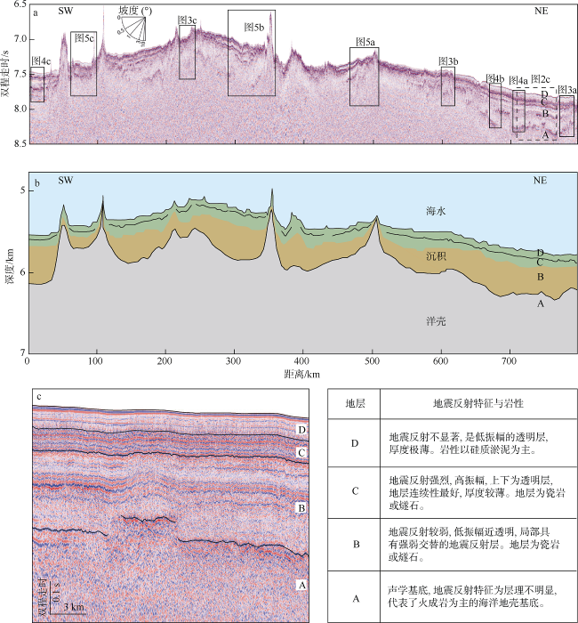
图2 横跨西太平洋侏罗纪洋壳的多道地震剖面(a)、地壳结构模型(b)与地层分类(c)长方形框显示具体的断层位置( Fig. 2 The 2D multichannel seismic profile across the west Pacific Jurassic oceanic crust (a), crustal structure model (b), and seismic stratigraphy (c). Rectangles indicate the enlarged segments, showing active faults in Figs. 3-5. Labels A, B, C, and D mark the interpreted stratigraphic units in the text. Crustal structure model is a result jointly constrained with the refraction velocity model from Feng (2016) and multichannel seismic reflection data interpretation in the text. Location of seismic profile is shown in |
图3 基底断层的地震剖面(上)、构造解释(中)和断层位移分析(下)A、B、C、D为解释的地层单元, 红色细线为解释的断层。F1、F2、F3为切穿基底和海底的活动断层。地震剖面位置见 Fig. 3 The enlarged seismic section of basement faults (top), structural interpretation (middle), and fault displacement analysis (bottom). Labels A, B, C, and D mark the mapped stratigraphic units. Red lines are interpreted faults. F1, F2, and F3 denote active faults that cut through the basement and seafloor. Locations of seismic segments are shown in |
图4 沉积断层的地震剖面(上)与构造解释(下)A, B, C, D为解释的地层单元, 红色细线为解释的断层。地震剖面位置见 Fig. 4 The enlarged seismic profile of sedimentary faults (top) and interpretation (bottom). Labels A, B, C, and D mark the interpreted stratigraphic units. Red lines are faults. Locations of seismic segments are shown in |
图5 垮塌断层的地震剖面(上) 、构造解释(中)和断层位移分析(下)A、B、C、D为解释的地层单元, 红色细线为解释的断层。F4、F5为切穿基底和海底的活动断层。地震剖面位置见 Fig. 5 The enlarged seismic section of sedimentary faults (top), structural interpretation (middle), and fault displacement analysis (bottom). Labels A, B, C, and D mark the interpreted stratigraphic units. Red lines are faults. F4 and F5 denote active faults that cut through the basement and seafloor. Locations of seismic segments are shown in |
表2 三类断层的性质Tab. 2 Properties of three mapped types of active faults |
| 断层类型 | 推测走向 | 倾向 | 倾角 | 最大垂直位移/s | 断层最大长度/s | 地表形变 | 错断基底 |
|---|---|---|---|---|---|---|---|
| 基底断层 | 99°~147° | 南西 | 80°~90° | 0.3 | 0.6 | 是 | 是 |
| 沉积断层 | / | / | 90° | / | 0.2 | 否 | 否 |
| 垮塌断层 | 115°~133° | 南西 | 85°~90° | 0.1 | 0.6 | 部分是 | 部分是 |
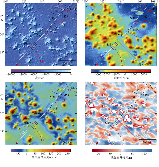
图6 研究区活动断层在海底地形(a)、剩余水深(b)、自由空间重力异常(c)以及地磁异常(d)的空间分布红色实线为文中解释的活动断层。黑色实线为已知的M系列地磁异常条带, 橙黄色虚线为磁条带相关的断裂带, 数据来自(Tominaga et al (2015)。红白色圆球表示5级及以上地震的震源机制(https://www.globalcmt.org)。白色地震测线TN272位置见 Fig. 6 Spatial distribution of interpreted active faults on the seafloor bathymetry (a), residual bathymetry (b), free-air gravity anomaly (c), and magnetic anomaly (d). Red lines are interpreted active faults in the text. Black lines denote M-series magnetic lineations, and dashed orange lines represent fracture zones. Data are from Tominaga et al (2015). Red-white balls represent focal mechanisms of earthquake with magnitude ≥5 (from https://www.globalcmt.org). Location of seismic profile TN272 in white line is shown in |
| [1] |
陈双双, 刘嘉麒, 2018. 中太平洋山脉白垩纪响岩质碱玄岩的地球化学特征及地质意义[J]. 中国科学 D辑: 地球科学, 48(5): 595-616.
|
| [2] |
陆鹿, 严立龙, 李秋环, 等, 2016. 洋底高原及其对地球系统意义研究综述[J]. 岩石学报, 32(6): 1851-1876.
|
| [3] |
罗怡鸣, 张锦昌, 林间, 2019. 太平洋大塔穆火山研究进展及对巨型洋底火山成因的启示[J]. 地球物理学进展, 34(2): 781-795.
|
| [4] |
庞洁红, 李三忠, 戴黎明, 等, 2011. 太平洋洋底高原和海山成因--重点以Shatsky海隆成因为例[J]. 海洋地质与第四纪地质, 31(2): 1-10.
|
| [5] |
且钟禹, 1996. 普通地质学[M]. 青岛: 青岛海洋大学出版社: 87-100.
|
| [6] |
宋晓晓, 李春峰, 2016. 西太平洋科学大洋钻探的地球动力学成果[J]. 热带海洋学报, 35(1): 17-30.
|
| [7] |
徐斐, 周祖翼, 2003. 洋底高原: 了解地球内部的窗口[J]. 地球科学进展, 18(5): 745-752.
|
| [8] |
徐义刚, 2002. 地幔柱构造、大火成岩省及其地质效应[J]. 地学前缘, 9(4): 341-353.
|
| [9] |
|
| [10] |
|
| [11] |
|
| [12] |
|
| [13] |
|
| [14] |
|
| [15] |
|
| [16] |
|
| [17] |
|
| [18] |
|
| [19] |
|
| [20] |
|
| [21] |
|
| [22] |
|
| [23] |
|
| [24] |
|
| [25] |
|
| [26] |
|
| [27] |
|
| [28] |
|
| [29] |
|
| [30] |
|
| [31] |
|
| [32] |
|
| [33] |
|
| [34] |
|
| [35] |
|
| [36] |
|
| [37] |
|
| [38] |
|
| [39] |
|
| [40] |
|
| [41] |
|
| [42] |
|
| [43] |
|
| [44] |
|
| [45] |
|
| [46] |
|
| [47] |
|
| [48] |
|
| [49] |
|
| [50] |
|
| [51] |
|
| [52] |
|
| [53] |
|
| [54] |
|
| [55] |
|
| [56] |
|
| [57] |
|
| [58] |
|
| [59] |
SHIPBOARD SCIENTIFIC PARTY, 1990a. Site 800[C]// LANCELOT Y, LARSON R. Proceedings of the ocean drilling program, initial reports (vol. 129) of the ocean drilling program. College Station: 33-89.
|
| [60] |
SHIPBOARD SCIENTIFIC PARTY 1990b. Site 801[C]// LANCELOT Y, LARSON R. Proceedings of the ocean drilling program, initial reports (vol. 129) of the ocean drilling program. College Station: 91-170.
|
| [61] |
|
| [62] |
|
| [63] |
|
| [64] |
|
| [65] |
|
| [66] |
|
| [67] |
|
| [68] |
|
| [69] |
|
| [70] |
|
/
| 〈 |
|
〉 |


