
Journal of Tropical Oceanography >
Morphodynamic processes of the Yintan Beach in response to typhoon
Copy editor: YAO Yantao
Received date: 2021-07-28
Revised date: 2022-01-08
Online published: 2022-01-19
Supported by
National Natural Science Foundation of China(41930537)
Fundamental Research Project of Guangxi Academy of Sciences(2020YBJ704)
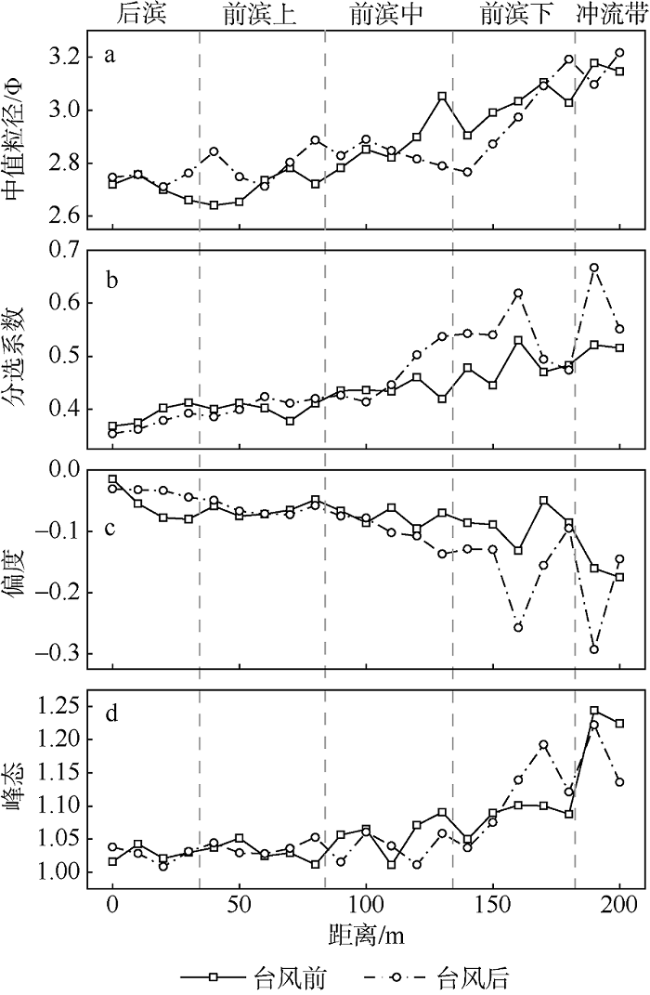
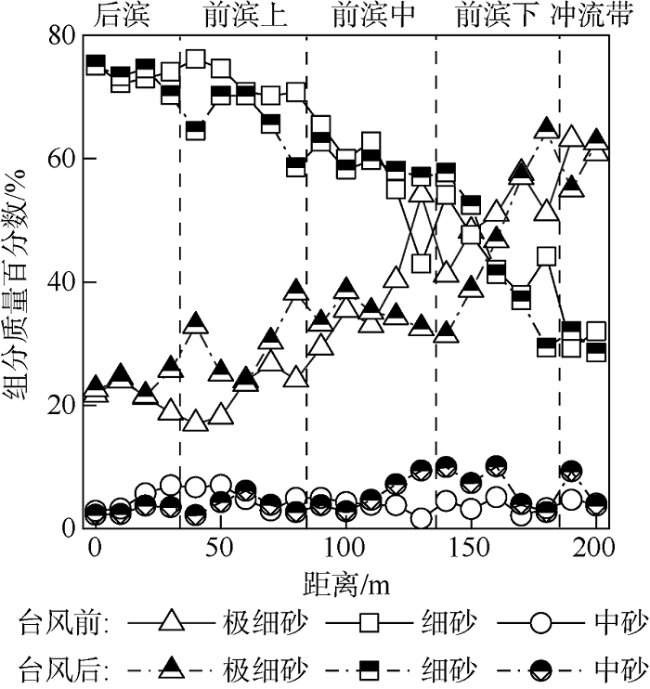
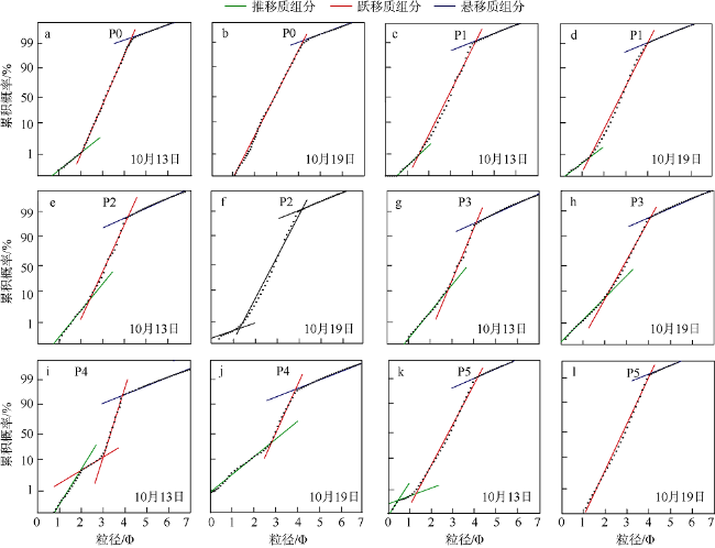
The beach morphodynamic process under the influence of extreme high-energy events is directly related to coastal stability and seawalls safety. Based on the profile elevation and surface sediments of the Yintan Beach collected before and after the 2020 16th typhoon “Nangka”, this paper explores the mechanism of morphological changes of a meso-tidal beach in response to typhoon actions. The results show that: (1) In post-typhoon period, the beach morphological changes are manifested by the disappearance of a large sand bar and the flattening of the bar-trough system, leading to a more gentle beach slope; (2) Sediment in Yintan Beach is mainly medium sand, fine sand and very fine sand, which account for more than 95%; The sediment grains become finer in the high tide zone and coarser in the low tide zone, while both increase and decrease in sediment grain size can occur near the sand bar; The morphodynamic process of mid-to-high tide zone of the Yintan Beach in response to a typhoon is similar to that of a macro-tidal beach, which is characterized by dissipative condition. However, the morphodynamic process of low tide zone of the Yintan Beach behaves like a micro-tidal beach due to the existence of a large sand bar; (3) During the typhoon, wave is the main dynamic factor affecting the beach, and the topography affects the manifestation of nearshore hydrodynamics, thereby changing the grain size distribution of sediment.
XI Yangyang , WANG Riming , FENG Bingbin , CHEN Bo . Morphodynamic processes of the Yintan Beach in response to typhoon[J]. Journal of Tropical Oceanography, 2022 , 41(4) : 97 -104 . DOI: 10.11978/2021097
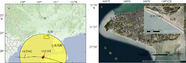
图1 台风“浪卡”路径(a)和采样剖面地理位置(b)图a基于国家测绘地理信息局标准地图服务网站下载的审图号为GS(2021)1487的标准地图制作。图b基于ESRI卫星影像绘制, 其中放大图中的黑线表示银滩的观测剖面 Fig. 1 Path of typhoon “Nangka” (a) and geographical location of the sampling profiles (b). The black line in the figure (b) represents the observation profile of the Yintan Beach |
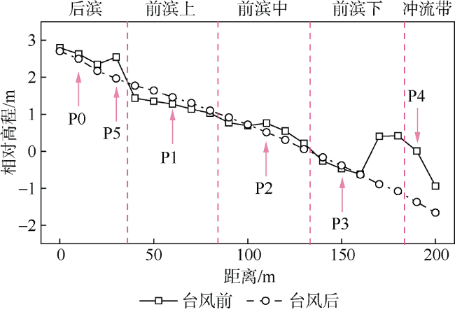
图2 台风前后剖面的相对高程变化图中方点和圆点分别代表台风前(2020年10月13日)和台风后(2020年10月19日)的采样位置; 垂直虚线将剖面分成后滨、前滨上、前滨中、前滨下和冲流带; 箭头指向点(P0—P5)为绘制沉积物粒度累积概率曲线的代表点 Fig. 2 Relative elevation changes of the profile before and after the typhoon. The square and circle points in the figure represent the sampling positions before the typhoon on October 13th, 2020 and after the typhoon October 19th, 2020, respectively; The dashed line divides the profile into backshore, foreshore and other parts; The red arrow points represent the cumulative frequency curves of sediments |
| [1] |
蔡锋, 苏贤泽, 夏东兴, 2004. 热带气旋前进方向两侧海滩风暴效应差异研究——以海滩对0307号台风“伊布都”的响应为例[J]. 海洋科学进展, 22(4): 436-445.
|
| [2] |
陈波, 董德信, 陈宪云, 等, 2017. 南海北部台风引起的广西近岸增减水研究[J]. 海洋湖沼通报, (2): 1-11.
|
| [3] |
陈宪云, 刘晖, 董德信, 等, 2013. 广西主要海洋灾害风险分析[J]. 广西科学, 20(3): 248-253.
|
| [4] |
陈子燊, 1995. 弧形海岸海滩地貌对台风大浪的响应特征[J]. 科学通报, 40(23): 2168-2170. (in Chinese)
|
| [5] |
戴志军, 李春初, 2008. 华南弧形海岸动力地貌过程[M]. 上海: 华东师范大学出版社. (in Chinese)
|
| [6] |
龚昊, 陈沈良, 钟小菁, 等, 2017. 海南岛东北部海滩侵蚀与恢复对连续台风的复杂响应[J]. 海洋学报, 39(5): 68-77.
|
| [7] |
黄鹄, 戴志军, 施伟勇, 等, 2011. 强潮环境下的海滩剖面沉积特征----以春季广西北海银滩为例[J]. 热带海洋学报, 30(4): 71-76.
|
| [8] |
黄祖明, 戴志军, 黎树式, 等, 2021. 中强潮海滩剖面冲淤过程研究——以北海银滩为例[J]. 海洋地质与第四纪地质, 41(4): 36-47.
|
| [9] |
吉学宽, 林振良, 闫有喜, 等, 2019. 海岸侵蚀、防护与修复研究综述[J]. 广西科学, 26(6): 604-613.
|
| [10] |
雷刚, 蔡锋, 2005. 福建江田下沙沙滩沉积地貌组合对台风的响应模式[J]. 台湾海峡, 24(3): 395-403.
|
| [11] |
黎树式, 戴志军, 葛振鹏, 等, 2017. 强潮海滩响应威马逊台风作用动力沉积过程研究——以北海银滩为例[J]. 海洋工程, 35(3): 89-98.
|
| [12] |
刘涛, 王增军, 张建兵, 2020. 广西北海银滩侵蚀动力研究[J]. 海洋学报, 42(7): 147-154.
|
| [13] |
|
| [14] |
|
| [15] |
|
| [16] |
|
| [17] |
|
| [18] |
|
| [19] |
|
| [20] |
|
| [21] |
|
| [22] |
|
| [23] |
|
| [24] |
|
| [25] |
|
| [26] |
|
| [27] |
|
| [28] |
|
| [29] |
|
/
| 〈 |
|
〉 |
