Review

New development on crustal structures of the Manila subduction in the eastern South China Sea

  • ZHAO Minghui , 1, 2, 6 ,
  • CHENG Jinhui 1, 2, 6 ,
  • GAO Jinwei 3 ,
  • SUN Longtao 1, 2 ,
  • XU Ya 4 ,
  • ZHANG Jiazheng 1, 2 ,
  • DU Feng 5
Expand
  • 1. Key Laboratory of Ocean and Marginal Sea Geology, South China Sea Institute of Oceanology, Chinese Academy of Sciences, Guangzhou 511458, China
  • 2. Guangdong Laboratory of Marine Science and Engineering, Guangzhou 511458, China
  • 3. Institute of Deep-sea Science and Engineering, Chinese Academy of Sciences, Sanya 572000, China
  • 4. Key Laboratory of Petroleum Resources Research, Institute of Geology and Geophysics, Chinese Academy of Sciences, Beijing 100029, China
  • 5. Hubei Key Laboratory of Earthquake Early Warning, Hubei Earthquake Agency, Wuhan 430071, China
  • 6. University of Chinese Academy of Sciences, Beijing 100049, China
ZHAO Minghui. email:

Copy editor: LIN Qiang

Received date: 2020-12-29

  Request revised date: 2021-01-20

  Online published: 2021-01-20

Supported by

Natural Science Foundation of China(91958212)

Natural Science Foundation of China(41730532)

Natural Science Foundation of China(91428204)

Natural Science Foundation of China(91858212)

Key Special Project for Introduced Talents Team of Southern Marine Science and Engineering Guangdong Laboratory (Guangzhou)(GML2019ZD0204)

Guangdong Natural Science Foundation research team project(2017A030312002)

Copyright

Copyright reserved © 2021. Office of Acta Agronomica Sinica All articles published represent the opinions of the authors, and do not reflect the official policy of the Chinese Medical Association or the Editorial Board, unless this is clearly specified.

Abstract

The key project of "Deep Structure survey and study on the Manila subduction zone in the eastern South China Sea (SCS)" was funded from the major research program "Deep Sea Processes and Evolution of the SCS" of the National Natural Science Foundation of China (NSFC) during 2015-2018. This project focuses on the Manila subduction zone to resolve the formation and evolution of the SCS using geological and geophysical methods. Five comprehensive geophysical surveys were successively carried out during the project period with the help of NSFC open cruises. A total of 73 Ocean Bottom Seismometer (OBS) stations and five Ocean Bottom ElectroMagnetometers (OBEM) have been deployed; and 13,872 airgun shots were fired. Totally 60 OBSs and five OBEMs have been recovered, and a large amount of data have been acquired. At the same time, a series of innovative results have been obtained. (1) The crust of the northeastern SCS has been determined as a 12-15 km thinned continental crust affected by volcanic activities after post-rifting phase based on the results of active seismic and earthquake tomography; and its continent-ocean boundary (COB) was also determined. (2) According to the multi-channel seismic reflection profile, the detailed structure of the accretionary wedge front of the northern Manila subduction zone was delineated. (3) The SCS oceanic crust domain when the seafloor spreading stopped has been outlined. (4) The tectonic evolution model of the SCS and the Philippine Sea Plate (PSP) was constructed. This project not only contributes substantially to the key scientific question (age and process of seafloor spreading) of the major research program "Deep Sea Processes and Evolution of the SCS," but also provides important basic data for the "skeleton" of the tectonic evolution and life history of the SCS from seafloor spreading to plate subduction, which has a far-reaching scientific significance.

Cite this article

ZHAO Minghui , CHENG Jinhui , GAO Jinwei , SUN Longtao , XU Ya , ZHANG Jiazheng , DU Feng . New development on crustal structures of the Manila subduction in the eastern South China Sea[J]. Journal of Tropical Oceanography, 2021 , 40(3) : 25 -33 . DOI: 10.11978/YG2020011
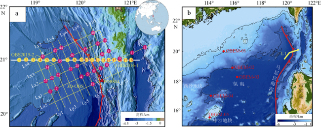
*感谢国家基金委员会共享航次计划(航次编号NORC2015-08、NORC2016-08)和“实验2”号科考船及全体出海人员在海上采集数据,在此一并致谢
南海作为西太平洋最大的边缘海之一, 是我国挺进深海大洋的根据地, 也是我国系统开展深海基础科学研究的首选(汪品先, 2009)。国家基金委“南海深海过程演变”重大研究计划力争通过“解剖一只麻雀”, 揭示边缘海的演变规律及其对海底资源和宏观环境的影响。在众多科学家大力推动下, 我国成功在南海实施的国际大洋发现计划IODP349/367/ 368/368X航次, 为探讨南海深部地壳结构、大陆岩石圈破裂机制和南海扩张演化生命史提供了更多的数据支撑(Larsen et al, 2018; Sun et al, 2019; Ding et al, 2020), 也为边缘海的演变历史树立起系统研究的典范(汪品先, 2012, 2020), 使南海成为国际海洋地球科学研究的天然实验室。
南海东部马尼拉俯冲带是新生代以来才逐步形成、正在活动的年轻俯冲带, 地震与火山活动极为活跃, 代表着南海从陆缘张裂、洋脊扩张、俯冲消亡的完整威尔逊旋回的顶点 (Ludwig et al, 1979; 李家彪 等, 2004; 尚继宏, 2008); 作为南海形成以来惟一的俯冲汇聚边界, 对于完整解剖南海这只“麻雀”的演化过程, 马尼拉俯冲带是至关重要的不可回避的环节, 是解决南海的形成与构造演化科学问题的关键之一(吴时国 等, 2004; 赵明辉 等, 2016)。2014年, 国家基金委重大研究计划“南海深海演变过程”重点支持项目“南海东部马尼拉俯冲带深部结构探测与研究”获得资助, 执行期间(2014—2018年)在马尼拉俯冲带开展了多次综合地球物理探测, 采集了宝贵的第一手海上数据, 取得创新性进展。本文介绍了该项目在海上取得的实验数据, 以方便更多的科学家申请与使用; 并总结了项目执行期间取得的4项重要研究成果, 为重大研究计划所提出的“从海底扩张到洋壳俯冲的南海生命史的骨架”科学问题提供重要支撑。

1 重要科学实验与关键数据

在国家基金委共享航次的资助下, 先后开展了5次综合地球物理探测, 投放海底地震仪(Ocean Bottom Seismometer, OBS)台站73台次, 海底电磁仪(Ocean Bottom ElectroMagnetometers, OBEM)5台次, 累积放炮达13,872炮, 成功获得了60台OBS和5台OBEM台站的宝贵数据(图1)。包括: 2015年二维主动源地震测线OBS2015-2; 2015年7—8月部署了7台长期宽频带OBS天然地震观测; 2016年4—6月完成的三维OBS地震探测; 2016年7—8月完成的二维主动源地震测线OBS2016-2; 及2015—2017年间三次共5个OBEM台次的海上实验。
主动源二维地震测线OBS2015-2(图1a), 以20km间隔共投放了9台OBS, 回收9台, 回收率100%, 剖面长度200km, 共激发有效炮1994炮, 放炮期间同步进行了近水面单道电缆接收, 获得单道反射地震剖面200km(刘思青 等, 2017); 主动源二维地震测线OBS2016-2, 是沿着OBS2015-2测线东西向延长(图1a), 共投放9台OBS, 回收9台, 回收率100%, 共放炮1078炮, 长130km; 以及沿着OBS测线的多道反射地震调查, 圆满完成了横跨马尼拉俯冲带主剖面的深地震调查任务。在巴士海峡区域(图1a)实施三维主动源OBS地震探测; 此次实验共投放48台国产便携式OBS, 回收41台, 放炮测线长2300km, 有效放炮10800次, 其中5 条北东—南西向测线(Lx), 11条北西—南东向测线(Ly)(Du et al, 2018; 张佳政 等, 2018)。
图1 项目实施的重要科学实验与关键数据

a中圆圈与三角形分别代表主动源和被动源OBS台站; b中红色圆点为OBEM台站, L1测线对应于图4中多道反射剖面的位置

Fig. 1 Significant scientific experiments and key data acquired during this project.

Circles and a triangle represent Ocean Bottom Seismometers (OBS) stations recording signals caused by active airgun-shooting and passive earthquakes, respectively, in (a). Circles in (b) indicate the Ocean Bottom ElectroMagnetometers (OBEM) stations; and the seismic line L1 corresponds to the multichannel reflection profile in Fig. 4

2015年7—8月, 通过搭载国家基金委共享航次, 在研究区部署了7台长期宽频带OBS, 于2016年2月仅回收1台(POBS04)(图1a), 有效记录时段为6个月, 记录了马尼拉海沟附近的天然地震数据, 有效约束了马尼拉俯冲板片形态(任昱 等, 2020)。
2015年7—8月和2017年5—6月通过基金委共享航次, 进行了3次OBEM测试和采集工作。第1次海试选择在南海北部进行海上采集实验, 主要检验OBEM在深水环境工作情况, 验证OBEM样机的工作状态及对深水环境探测能力, 为OBEM投入实际应用积累实践经验。第2次海试重点验证了OBEM投放与回收操作性能。由于OBEM电极臂较长, 投放与回收比较困难。经过在实验2号的两次投放与回收实验对比, 采用尾部投放、侧位回收的方案较为理想。第3次海试, 共获得5个OBEM站位的有效数据(图1b)。其中OBEM-01和OBEM-02站点位于陆坡处, 海底地形起伏较大, OBEM-03站点位于海盆边缘, OBEM-04、OBEM-05站点位于中沙群岛附近, 进一步数据处理与分析正在进行之中(Xu et al, 2017)。
在项目成员与基金委南海北部地球物理共享航次通力合作和共同努力, 完成了各项地球物理数据的采集任务。为了更好地利用新采集的数据资料, 充分发挥共享航次的作用, 下船后主导科学家和有数据需求的科学家共同签署《数据共享协议》, 保证主导科学家项目的完成和数据优先使用权, 同时实现数据资料共享, 所有数据交给国家基金委资料共享中心, 共同推进南海深地震探测研究快速发展。

2 南海东北部地壳属性及洋陆边界的确定

2015年7—8月期间采集的广角反射/折射深地震测线OBS2015-2位于马尼拉俯冲带前缘(图1a)。基于2015年采集的多道地震剖面建立初始正演模型, 通过时深转换, 获取海底、沉积层、基底深度信息, 模型长189.6km。9台OBS记录的地震数据, 震相清晰。通过走时拟合与射线追踪, 发现来自深部的P波震相信息, 包括PsP、Pg、PmP和Pn, 并发现了下地壳高速层折射震相(PhP)与反射震相(Ph); 8个台站共拾取到7977个走时(OBS02台站无有效数据)(刘思青 等, 2017)。接着采用二维射线追踪程序RayInvr(Zelt et al, 1992)与走时层析成像方法Tomo2D(Korenaga et al, 2000)获取OBS2015-2测线下方的速度结构(图2)。速度结构模型及OBS台站下方一维速度结构揭示南海东北部地壳厚度为12~15km, 发育有下地壳底侵高速层, 前人认为这是东西向海底扩张形成的磁异常条带(C15—C17)(Hsu et al, 2004), 最新的研究认为是岩浆活动形成的具有高磁特征的火山岩脊; 在本质上, 南海东北部的地壳属于受到张裂期后岩浆活动影响的减薄陆壳(Liu et al, 2018; Zhao et al, 2018)。基于最新的IODP349和IODP367/368航次数据, 确定了南海北部陆缘的洋陆边界COB(图3)(Liu et al, 2018), 为南海停止扩张时洋壳范围的推断提供了证据。
图2 OBS2015-2测线下方的速度结构

a、b分别为正演和反演速度结构模型; c、d是分别从a和b速度模型中提取的OBS台站下方一维速度结构

Fig. 2 Velocity structure along the profile OBS2015-2.

(a) and (b) showing the forward and inverted velocity structures, respectively. (c) and (d) are one-dimensional velocity structures beneath each OBS station, which was extracted from the forward (a) and inverse velocity structures (b), respectively
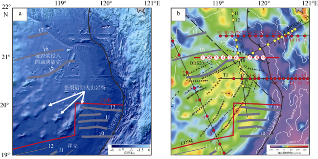
图3 南海东北部陆缘洋陆边界图

a为南海东北部地形水深图; b为自由空间重力异常图; 其中图中灰色线段为磁异常条带, 黑色交叉线条为张裂期后火山岩脊形成的构造高地(Briais et al, 1993; Hsu et al, 2004; Sibuet et al, 2016)

Fig. 3 Continent-Ocean Boundaries in the northeastern continental margin of the South China Sea.

(a) The bathymetry map in the northeastern SCS. (b) The free-air gravity map in the northeastern SCS. Grey lines indicate magnetic anomalies, and black lines with crosses in (b) indicate structural highs (elongated volcanic intrusions) referenced by Briais et al (1993), Hsu et al (2004), and Sibuet et al (2016)

3 马尼拉俯冲带增生楔前缘的精细结构

基于高分辨率多道地震反射剖面, 对马尼拉俯冲带增生楔前缘的构造变形、岩浆活动和深部反射等特征进行了分析和刻画(高金尉 等, 2018)。增生楔下陆坡部分由盲冲断层、构造楔和叠瓦逆冲断层构成, 逆冲断层归并于一条位于下中新统的滑脱面上, 滑脱面向海方向的展布明显受到增生楔之下埋藏海山和基底隆起的影响; 靠近海沟的海盆区域以及增生楔前缘岩浆活动开始于晚中新世末期并持续至第四纪。重震联合模拟结果表明, 俯冲带北段19°N—21°N区域是南海东北部陆缘向海盆的延伸, 是陆壳高度减薄的区域, 并受到岩浆活动的强烈改造, 从而导致其浮力较大, 产生的平缓俯冲作用造成海沟北段的几何形态明显地向东凹进(图4)。
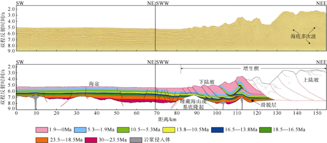
图4 马尼拉俯冲带北段增生楔多道地震反射剖面和解释[据高金尉等 (2018)修改]

剖面位置见图1b

Fig. 4 Multi-channel seismic reflection profile (upper) and interpretation (lower) of accretionary prism of northern Manila subduction (after Gao et al, 2018).

The location of this profile is shown in
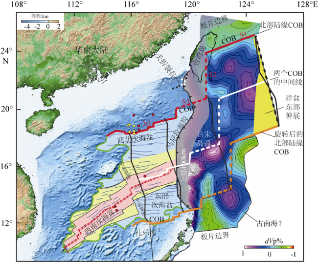
 Fig. 1b

4 南海在停止扩张时(约15Ma)洋壳范围

南海在约15Ma停止扩张时具有多大洋壳范围?马尼拉海沟何时开始俯冲?将沿着马尼拉海沟已经俯冲下去的南海板片恢复出来是解决南海形成演化动力学的关键。基于天然地震层析成像方法生成的P波速度波动(dVP)图, 展示了南海俯冲板片已经向东俯冲到达海沟以下450km深度(Wu et al, 2016)。将南海东边已经俯冲到马尼拉海沟之下的洋壳范围展平到地球表面上, 俯冲板片沿海沟向东恢复到400~500km, 板片南北两侧dVP负值区域对应着陆壳, dVP正值区域通常对应着洋壳, 较小的负值区(-0.1%dVP)对应着减薄陆壳; 根据dVP正负差异, COB在恢复的俯冲板片上向北延伸至400km, 位于西琉球俯冲带以下, 在南北向上欧亚板块与碰撞前的吕宋岛弧平行(图5), 锆石裂变径迹研究(Lee et al, 2015)显示, 在5—6Ma, 吕宋岛弧在约400km长的欧亚板块边界上同时碰撞。上述研究结果很好地为南海地球动力学机制提供了新的约束。
图5 南海在停止扩张时(15Ma)洋壳范围

Zhao等(2019)修改。将俯冲下去的南海板片(速度波动图)展平到地球表面上, 沿海沟向东伸展了400~500km。绿色实线圈闭的是现今南海洋壳范围(Sibuet et al, 2016), 东部为已俯冲下去的洋壳范围。灰色阴影区域(宽度<100km)为具有边界效应的不确实区域。粉色、黄色和浅蓝色分别代表南海不同扩张时期产生的洋壳, 扩张方向分别为N055°、N075°、N085°。洋壳内部的红色双虚线代表南海残余扩张脊(He et al, 2016)。红色粗线为COB边界, 实心圆为IODP钻探井位

Fig. 5 The whole oceanic crust domain when the SCS seafloor spreading stopped (15Ma); after Zhao et al (2019).

The subducted SCS plate (dVP) is unfolded and restored on the surface of the Earth, and the plate extends 400-500 km east along the Manila trench. The green line is the current SCS domain (Sibuet et al, 2016), and the east part is the domain of subducted SCS oceanic crust. The grey shaded area (<100 km width) is probable artifacts. The SCS oceanic domain, characterized by N055°, N075° and N085° seafloor spreading directions, is delimited by pink, yellow and light blue areas, respectively. The red double dashed line indicates the extinct spreading ridge of the SCS (He et al, 2016), the red line indicates COB, and the circles indicate the location of IODP drilling sites

5 建立南海与菲律宾海板块的构造演化模式

南海与菲律宾海板块在构造演化上关系密切。南海陆缘张裂主要分为两期; 第一次裂谷发生在始新世早期(56—40Ma), 以多裂谷盆地呈30°~45°排列为特征(Zhou et al, 1995; Lei et al, 2019); 第二次裂谷发生在始新世晚期(40—33Ma), 以新的45°~70°张裂方向, 形成的裂谷盆地中充满了黑色页岩, 夹砂岩层(Zhou et al, 1995; Lei et al, 2019)。第一次裂谷阶段仅发生在陆缘上部, IODP钻孔U1501的北部, 其南部没有发生(Larsen et al, 2018; Lei et al, 2019)。而在菲律宾海域, 从磁异常分布可以分为两个主要扩张阶段(Doo et al, 2015): 扩张第一阶段始于Chron 24(53.2Ma), 可能更早于Chron 25(56.9Ma)或 26(58.6Ma); 由于Oki Daito洋脊的后期形成过程中, 破坏了原来的构造, 导致这两个时间得不到很好的确定。第一阶段扩张结束发生在Chron 20(42.5Ma)(Wu et al, 2016); 第二阶段开启始于Chron 19(40.4Ma), 止于Chron 13(33.7Ma)。
南海陆缘张裂的第一阶段(56—40Ma)刚好对应菲律宾海扩张的第一阶段, 从53.2Ma(可能在Chrons 25或26之前几Ma)到42.5Ma(可能在Chrons 20和19之间)。南海陆缘张裂的第二阶段(40—33Ma)刚好对应于菲律宾海扩张的第二阶段(42.5—33.7Ma)。因此, 在始新世, 南海大陆边缘和菲律宾海板块(Philippine sea plate, PSP)均处于张性构造阶段(Zhao et al, 2019)。由于PSP最初位于南海南侧约2200km处, 有一个由南向北的运动形态, 在南海大陆边缘有伸展过程和海底扩张时, 这两个区域由左旋剪切板块边界连接。在15Ma(图6a), 将加瓜海脊和早白垩纪花东海盆外推到琉球海沟的当前位置(Hall, 2002)。截面AA′(图6c)显示了从南海东部盆地到加瓜海脊西部的PSP。随着PSP不断向北移动, 马尼拉俯冲带开始呈现左旋剪切运动, 大部分剪切运动持续到今天(Zhao et al, 2019)。吕宋弧在约12Ma时开始形成, 大约6Ma吕宋弧的北部开始沿南北走向、长400km的部分, 与欧亚板块发生碰撞(图6b), 对应的截面BB’(图6c)展示了这一运动过程。
图6 15Ma以来南海与菲律宾海板块演化过程示意图

Zhao等(2019)修改。a. 约15Ma时, 南海洋壳沿着左侧剪切边界开始俯冲, 至菲律宾海板块下面; b. 菲律宾断裂带、花东海盆的增生部分和吕宋岛弧西部的当前位置; c. 截面AA′和BB′简化示意图, 截面位置在a和b中黑线。深绿色: 早白垩世花东海盆; 浅绿色: 现今的菲律宾海板块; 中绿色: 浅灰色的菲律宾海板块部分在花东海盆的延伸, 随后俯冲消亡; 黄色: 海底扩张结束时南海的东部延伸; 橙色: Wu等(2016)定义的东亚板块的一部分; 浅粉色: 苏禄海东北延伸

Fig. 6 The kinematic evolution of the SCS and PSP since 15 Ma (after Zhao et al, 2019).

(a) About 15 Ma, the oceanic crust of the SCS started to subduct along the left shear plate boundary to the bottom of the PSP. (b)The current location of the emplacement of the Philippine belt, the accretion of the western part of the Huatung Basin and the western Luzon arc. (c) A simplified diagram of profile AA’ and BB’ located in (a) and (b), respectively. Dark green: early Cretaceous HB; light green: current PSP; extension of the HB within the portion of PSP in light grey, which will subduct to be disappeared; yellow area: eastern extension of the SCS at the end of seafloor spreading; orange domain: part of East Asian Plate defined by Wu et al (2016); and pink domain: the northeastern extension of the Sulu Sea

6 结论与展望

为期8年的南海深部计划研究积累了丰富的探索深海的基础资料, 取得了一系列创新研究成果(汪品先, 2020)。其中 “南海东部马尼拉海沟俯冲带深部结构探测与研究”是重点支持项目之一, 基于人工地震探测及天然地震层析成像结果, 确定了南海东北部地壳属于受到张裂后期岩浆活动影响的减薄陆壳, 同时联合国际大洋钻探成果, 划分了南海北部陆缘洋陆边界COB位置, 刻画了马尼拉俯冲带北段增生楔前缘的精细结构, 进而圈定了南海停止扩张时的洋壳范围, 并初步构建了南海与菲律宾海板块的构造演化模型。该项目对于揭示南海形成演化及其动力学过程具有重要意义, 而南海也逐步成为深海科学研究的天然实验室及边缘海系统研究的典范。
随着基础数据的不断充实, 以及新技术新手段的不断引入, 南海研究也不断涌现新的科学问题, 例如: 南海扩张后期岩浆活动的特征与机制; 马尼拉俯冲带地貌、构造和南海俯冲板块形态由北向南的变化及其空间耦合关系; 南海张裂-破裂机制与西太平洋边缘海系统的成因联系; 南海由东向西打开的动力来源; 此外, 位于欧亚板块与菲律宾海板块交汇处的花东海盆, 是现今西太平洋俯冲体系中唯一遗留的早白垩纪洋盆, 也成为研究西太平洋整体构造演化与动力学机制的关键区域(李春峰 等, 2007; 黄奇瑜, 2017; 林间 等, 2017)。国家基金委“西太平洋地球系统多圈层相互作用”重大研究计划(2018—2025)立足科学前沿和国家需求, 其重点支持项目“花东海盆及其东/西部板块边界的跨圈层综合地震探测(2020—2023)”旨在加强花东海盆多学科的构造属性及形成演化研究, 为构建西太平洋俯冲构造体系跨圈层的构造演化模式提供重要的地质和地球物理证据(赵明辉 等, 2020), 推动板块构造理论发展与完善; 同时, 该项目也将为中国未来在花东海盆的大洋钻探计划(黄奇瑜, 2017)提供重要的基础数据, 引领科学前沿。
[1]
高金尉, 吴时国, 姚永坚, 等, 2018. 马尼拉俯冲带北段增生楔前缘构造变形和精细结构[J]. 地球物理学报, 61(7):2845-2858.

GAO JINWEI, WU SHIGUO, YAO YONGJIAN, et al, 2018. Tectonic deformation and fine structure of the frontal accretionary wedge, northern Manila subduction zone[J]. Chinese Journal of Geophysics, 61(7):2845-2858 (in Chinese with English abstract).

[2]
黄奇瑜, 2017. 台湾岛的年龄[J]. 中国科学: 地球科学, 47(4):394-405.

HUANG QIYU, 2017. Geological ages of Taiwan stratigraphy and tectonic events[J]. Scientia Sinica Terrae, 47(4):394-405 (in Chinese with English abstract).

[3]
李春峰, 周祖翼, 李家彪, 等, 2007. 台湾岛南部海域的前碰撞构造地球物理特征[J]. 中国科学(D辑: 地球科学), 37(5):649-659.

[4]
李家彪, 金翔龙, 阮爱国, 等, 2004. 马尼拉海沟增生楔中段的挤入构造[J]. 科学通报, 49(10):1000-1008.

[5]
林间, 徐敏, 周志远, 等, 2017. 全球俯冲带大洋钻探进展与启示[J]. 地球科学进展, 32(12):1253-1266.

LIN JIAN, XU MIN, ZHOU ZHIYUAN, et al, 2017. Ocean drilling investigation of the global subduction processes[J]. Advances in Earth Science, 32(12):1253-1266 (in Chinese with English abstract).

[6]
刘思青, 赵明辉, 张佳政, 等, 2017. 马尼拉海沟俯冲带前缘(21°N)海底地震仪数据处理初步成果[J]. 热带海洋学报, 36(2):60-69.

LIU SIQING, ZHAO MINGHUI, ZHANG JIAZHENG, et al, 2017. OBS seismic data processing of the Manila Trench subduction zone (21°N) and some preliminary results[J]. Journal of Tropical Oceanography, 36(2):60-69 (in Chinese with English abstract).

[7]
任昱, 赵明辉, 张佳政, 等, 2020. 宽频带海底地震仪的地震重定位对马尼拉俯冲板片形态的约束[J]. 地球物理学报, 63(5):1927-1937.

REN YU, ZHAO MINGHUI, ZHANG JIAZHENG, et al, 2020. Constraint on the shape of the Manila subduction slab from earthquake relocation using long-term ocean bottom seismometer data[J]. Chinese Journal of Geophysics, 63(5):1927-1937 (in Chinese with English abstract).

[8]
尚继宏, 2008. 马尼拉海沟中北段俯冲带特征对比及区域构造动力学研究[D]. 青岛: 中国科学院研究生院(海洋研究所).

SHANG JIHONG, 2008. Tectonic dynamics research and subducting characteristics comparison between middle and northern part of Manila subducting belt[D]. Qingdao: Graduate University of Chinese Academy of Science (The Institute of Oceanology)(in Chinese with English abstract).

[9]
汪品先, 2009. 南海——我国深海研究的突破口[J]. 热带海洋学报, 28(3):1-4.

WANG PINXIAN, 2009. Toward scientific breakthrough in the South China Sea[J]. Journal of Tropical Oceanography, 28(3):1-4 (in Chinese with English abstract).

[10]
汪品先, 2012. 追踪边缘海的生命史: “南海深部计划”的科学目标[J]. 科学通报, 57(20):1807-1826.

WANG PINXIAN, 2012. Tracing the life history of a marginal Sea——On the “South China Sea Deep” research program[J]. Chinese Science Bulletin, 57(24):3093-3114.

[11]
汪品先, 2020. 南海深部过程的探索[J]. 科技导报, 38(18):6-20.

WANG PINXIAN, 2020. Exploring the deep sea processes in the South China Sea[J]. Science & Technology Review, 38(18):6-20 (in Chinese with English abstract).

[12]
吴时国, 刘文灿, 2004. 东亚大陆边缘的俯冲带构造[J]. 地学前缘, 11(3):15-22.

WU SHIGUO, LIU WENCAN, 2004. Tectonics of subduction zone in the East Asia continental margin[J]. Earth Science Frontiers, 11(3):15-22 (in Chinese with English abstract).

[13]
张佳政, 丘学林, 赵明辉, 等, 2018. 南海巴士海峡三维OBS探测的异常数据恢复[J]. 地球物理学报, 61(4):1529-1538.

ZHANG JIAZHENG, QIU XUELIN, ZHAO MINGHUI, et al, 2018. Abnormal data retrieval of three-dimensional OBS survey at the Bashi Channel area of the South China Sea[J]. Chinese Journal of Geophysics, 61(4):1529-1538 (in Chinese with English abstract).

[14]
赵明辉, 贺恩远, 孙龙涛, 等, 2016. 马里亚纳海沟俯冲带深地震现状对马尼拉海沟俯冲带的研究启示[J]. 热带海洋学报, 35(1):48-60.

ZHAO MINGHUI, HE ENYUAN, SUN LONGTAO, et al, 2016. Research on deep seismic structures of Mariana Trench subduction zone and its inspiration for Manila Trench subduction zone[J]. Journal of Tropical Oceanography, 35(1):48-60 (in Chinese with English abstract).

[15]
赵明辉, 王强, 杨富东, 等, 2021. 花东海盆综合地震探测及其重要的构造意义[J]. 地球科学, 46(1):359-368.

ZHAO MINGHUI, WANG QIANG, YANG FUDONG, et al, 2021. Seismic survey in Huatung basin and its tectonic significance[J]. Earth Science, 46(1):359-368 (in Chinese with English abstract).

[16]
BRIAIS A, PATRIAT P, TAPPONNIER P, 1993. Updated interpretation of magnetic anomalies and seafloor spreading stages in the south China Sea: Implications for the Tertiary tectonics of Southeast Asia[J]. Journal of Geophysical Research: Solid Earth, 98(B4):6299-6328.

[17]
DING WEIWEI, SUN ZHEN, MOHN G, et al, 2020. Lateral evolution of the rift-to-drift transition in the South China Sea: Evidence from multi-channel seismic data and IODP Expeditions 367&368 drilling results[J]. Earth and Planetary Science Letters, 531:115932.

DOI

[18]
DOO W B, HSU S K, LO C L, et al, 2015. Gravity anomalies of the active mud diapirs off southwest Taiwan[J]. Geophysical Journal International, 203(3):2089-2098.

DOI

[19]
DU FENG, ZHANG JIAZHENG, YANG FUDONG, et al, 2018. Combination of Least Square and Monte Carlo Methods for OBS Relocation in 3D Seismic Survey Near Bashi Channel[J]. Marine Geodesy, 41(5):494-515.

DOI

[20]
HALL R, 2002. Cenozoic geological and plate tectonic evolution of SE Asia and the SW Pacific: Computer-based reconstructions, model and animations[J]. Journal of Asian Earth Sciences, 20(4):353-431.

DOI

[21]
HE ENYUAN, ZHAO MINGHUI, QIU XUELIN, et al, 2016. Crustal structure across the post-spreading magmatic ridge of the East Sub-basin in the South China Sea: Tectonic significance[J]. Journal of Asian Earth Sciences, 121:139-152.

DOI

[22]
HSU S K, YEH Y C, DOO W B, et al, 2004. New bathymetry and magnetic lineations identifications in the northernmost South China Sea and their tectonic implications[J]. Marine Geophysical Research, 25(1-2):29-44.

DOI

[23]
KORENAGA J, HOLBROOK W S, KENT G M, et al, 2000. Crustal structure of the southeast Greenland margin from joint refraction and reflection seismic tomography[J]. Journal of Geophysical Research: Solid Earth, 105(B9):21591-21614.

[24]
LARSEN H C, MOHN G, NIRRENGARTEN M, et al, 2018. Rapid transition from continental breakup to igneous oceanic crust in the South China Sea[J]. Nature Geoscience, 11(10):782-789.

DOI

[25]
LEE Y H, BYRNE T, WANG W H, et al, 2015. Simultaneous mountain building in the Taiwan orogenic belt[J]. Geology, 43(5):451-454.

DOI

[26]
LEI CHAO, REN JIANYE, PANG XIONG, 2019. Rift structures and its related unconformities on and adjacent the Dongsha Rise: insights into the nature of the high-velocity layer in the northern South China Sea[J]. Marine Geophysical Research, 40(2):99-110.

DOI

[27]
LIU SIQING, ZHAO MINGHUI, SIBUET J C, et al, 2018. Geophysical constraints on the lithospheric structure in the northeastern South China Sea and its implications for the South China Sea geodynamics[J]. Tectonophysics, 742-743:101-119.

DOI

[28]
LUDWIG W J, KUMAR N, HOUTZ R E, 1979. Profiler-sonobuoy measurements in the South China Sea Basin[J]. Journal of Geophysical Research: Solid Earth, 84(B7):3505-3518.

[29]
SIBUET J C, YEH Y C, LEE C S, 2016. Geodynamics of the South China Sea[J]. Tectonophysics, 692:98-119.

DOI

[30]
SUN ZHEN, LIN JIAN, QIU NING, et al, 2019. The role of magmatism in the thinning and breakup of the South China Sea continental margin[J]. National Science Review, 6(5):871-876.

DOI

[31]
WU J, SUPPE J, LU RENQI, et al, 2016. Philippine Sea and East Asian plate tectonics since 52 Ma constrained by new subducted slab reconstruction methods[J]. Journal of Geophysical Research: Solid Earth, 121(6):4670-4741.

DOI

[32]
XU YA, YOU QINGYU, HUANG SONG, et al, 2017. Marine electromagnetic experiments in the South China Sea[C]// International Geophysical Conference. Qingdao, China: SEG: 917-919.

[33]
ZELT C A, SMITH R B, 1992. Seismic traveltime inversion for 2-D crustal velocity structure[J]. Geophysical Journal International, 108(1):16-34.

DOI

[34]
ZHAO MINGHUI, HE ENYUAN, SIBUET J C, et al, 2018. Postseafloor spreading volcanism in the Central East South China Sea and its formation through an extremely thin oceanic crust[J]. Geochemistry, Geophysics, Geosystems, 19(3):621-641.

DOI

[35]
ZHAO MINGHUI, SIBUET J C, WU J, 2019. Intermingled fates of the South China Sea and Philippine Sea plate[J]. National Science Review, 6(5):886-890.

DOI

[36]
ZHOU DI, RU KE, CHEN HANZONG, 1995. Kinematics of Cenozoic extension on the South China Sea continental margin and its implications for the tectonic evolution of the region[J]. Tectonophysics, 251(1-4):161-177.

DOI

Outlines

/