
Journal of Tropical Oceanography >
Reconstruction of the tropical cyclones activity in the Nansha Islands since the Little Ice Age from the atoll lagoon sediments
Copy editor: LIN Qiang
Received date: 2022-01-27
Revised date: 2022-04-14
Online published: 2022-04-18
Supported by
Key Special Project for Introduced Talents Team of Southern Marine Science and Engineering Guangdong Laboratory (Guangzhou)(GML2019ZD0206)
Innovation Academy of South China Sea Ecology and Environmental Engineering, Chinese Academy of Sciences(ISEE2018PY01)
Strategic Priority Research Program of the Chinese Academy of Sciences(XDA13010103)
Tropical cyclones (TCs) and the resultant storm surges and heavy rainfall have posed huge socio-economic threats to the coastal areas of the South China Sea (SCS) and its surrounding areas. Holocene TCs studies before instrumental record help to accurately predict trends in TCs activity in the context of global warming. Here, we presented a new sub-annually resolved paleostorm record from the Anle reef lagoon sediments of the Nansha Islands in the southern SCS since the relative cold Little Ice Age (LIA) and a total of 28 storm event layers were identified. The new reconstruction indicates that the site has witnessed frequent TCs variations on a decadal to centennial-scale since the LIA, and two main storm active periods have been developed. The most intense storm activity period occurred in the early LIA (AD 1471~1620), and the other relatively active period was witnessed in the Current Warm Period (CWP) of AD 1930~1960. Although the storm activity in CWP was strengthened, it was significantly lower than that in the early LIA. Regional comparison with the storm reconstruction record of the Yongshu Reef during the same period reveals distinct spatio-temporal heterogeneity in the southern SCS. More high-resolution storm records from similar or adjacent regions could effectively reduce the uncertainty of storm reconstructions and increase the accuracy of reconstructed records.
YANG Hongqiang , TAN Fei , XU Huilong , ZHANG Xiyang , SHI Qi , TAO Shichen . Reconstruction of the tropical cyclones activity in the Nansha Islands since the Little Ice Age from the atoll lagoon sediments[J]. Journal of Tropical Oceanography, 2022 , 41(6) : 171 -182 . DOI: 10.11978/2022016
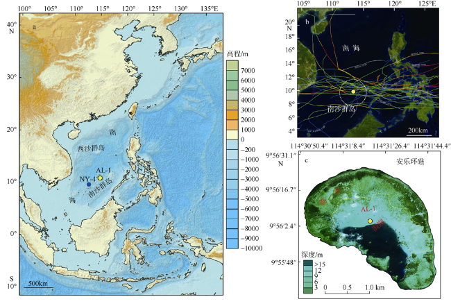
图1 研究区位置及气象和地貌学特征a. 南海和西北太平洋地理位置及热带气旋历史记录, 该图依据审图号GS(2016)2937号底图制作, 黄色圆圈标注为本研究中的采样位置安乐礁潟湖, 永暑礁NY-4风暴记录以蓝色圆圈表示; b. IBTrACS Hurricane Datase数据库中提供的南沙群岛附近历史热带气旋移动路径(该图来源于 https://coast.noaa.gov/hurricanes/, 图中为热带风暴强度及以上级别热带气旋路径, 白色虚线圆圈代表以安乐礁为中心半径为300km范围内的热带气旋活动路径); c. 安乐礁位置和地貌分区(该图根据google卫星遥感图像制作, 黄色圆圈代表岩心AL-1采集地点, 黄色虚线表示礁坪和潟湖之间的边界) Fig. 1 Study location and the regional atmosphere-geomorphology context |
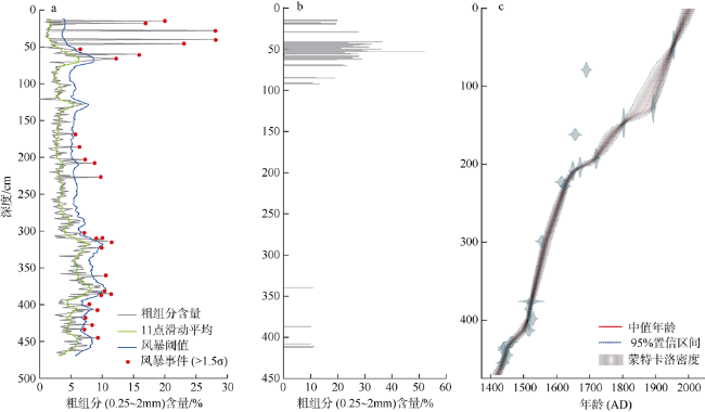
图3 AL-1岩心粗组分异常和风暴事件层数百年滑动窗口红线代表粗组分含量的11点滑动平均值(去掉>10%的异常值), 绿线代 Fig. 3 The Coarse sediment anomalies and 100-year sliding window on the number of storm event layers recorded by core AL-1 |
表1 1945—2020年登陆南沙群岛安乐礁和永暑礁不同半径范围内的不同强度热带气旋的频率Tab. 1 The historical tropical cyclones passing within different distances from the Anle Reef and the Yongshu Reef in the Nansha Islands, southern SCS between 1945~2020 |
| 珊瑚礁区 | 半径范围 | 热带风暴及以上级别热带气旋 | 每百年频率 | ≥cat 1级别热带气旋 | 每百年 频率 | ≥cat 2级别热带气旋 | 每百年 频率 | ≥cat 3级别热带气旋 | 每百年 频率 |
|---|---|---|---|---|---|---|---|---|---|
| 安乐礁 | r<300km | 75.0 | 100.0 | 17.0 | 22.7 | 9.0 | 12.0 | 3.0 | 4.0 |
| r=115km | 16.0 | 21.3 | 5.0 | 6.7 | 3.0 | 4.0 | 1.0 | 1.3 | |
| r=60km | 10.0 | 13.3 | 2.0 | 2.7 | 1.0 | 1.3 | 1.0 | 1.3 | |
| 永暑礁 | r<300km | 67.0 | 89.3 | 15.0 | 20.0 | 8.0 | 10.7 | 1.0 | 1.3 |
| r=115km | 18.0 | 24.0 | 6.0 | 8.0 | 2.0 | 2.7 | 1.0 | 1.3 | |
| r=60km | 6.0 | 8.0 | 2.0 | 2.7 | 1.0 | 1.3 | 1.0 | 1.3 |
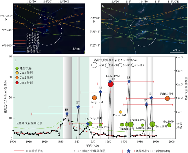
图4 安乐礁现代器测热带气旋移动路径和沉积物记录敏感性校准a. 经过南海南部安乐礁115km半径范围内的热带气旋活动历史路径; b. 60km范围内近距离影响安乐礁的热带气旋活动路径; c. 岩心顶部1900—2001 AD的粗组分含量百分比与现代热带气旋观测记录的校准和敏感性评估。蓝色五角星代表超过事件阈值的粗粒沉积峰, 其中事件层E8为附近几个小峰的合并; 不同颜色和大小的圆分别代表了某一热带气旋过境安乐礁附近115km范围内的强度和距离安乐礁的最短直线距离, 圆半径越大代表距离安乐礁越近。每个事件层标注了基于贝叶斯模型的2σ年龄误差。现代热带气旋移动路径观测记录来源于 https://coast.noaa.gov/hurricanes/在线数据库网站, 统计时间区间为1945—2020年 Fig. 4 Sensitivity calibration of the sediment records to the modern instrumented tropical cyclone tracks passed near the Anle Reef |
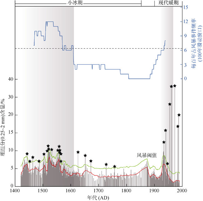
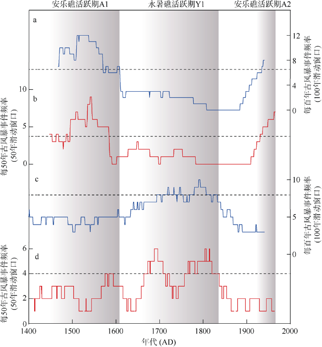
图5 小冰期以来南海南部安乐礁和永暑礁潟湖的古风暴事件频率对比a. 安乐礁古风暴事件数量100年滑动窗口; b. 安乐礁古风暴事件数量50年滑动窗口; c. 永暑礁古风暴事件100年滑动窗口数; d. 永暑礁古风暴事件50年滑动窗口数(Yu et al, 2009)。滑动窗口数中的黑色虚线代表该经过该区域115km范围内的局地热带气旋估计频率。50年滑动窗口中的估计频率按照100年滑动窗口频率的50%计算 Fig. 5 Comparison of the paleostorms events recorded in the Anle and Yongshu Reef Lagoon, southern South China Sea since the LIA |
| [1] |
高抒, 贾建军, 杨阳, 等, 2019. 陆架海岸台风沉积记录及信息提取[J]. 海洋学报, 41(10): 141-160.
|
| [2] |
廖菲, 李文婷, 张子然, 等, 2019. 1949-2017年南海海域热带气旋强度和路径快速变化统计特征[J]. 海洋学报, 41(9): 126-135.
|
| [3] |
陶丽, 张艺帆, 王学兵, 2020. 南海与西北太平洋地区夏季热带气旋潜在生成指数的改进[J]. 大气科学学报, 43(4): 603-616.
|
| [4] |
徐笑梅, 高抒, 周亮, 等, 2019. 海南岛东北部海岸极端波浪事件沉积记录[J]. 海洋学报, 41(6): 48-63.
|
| [5] |
张敏, 罗军, 胡金磊, 等, 2019. 雷州市沿海风暴潮淹没危险性评估[J]. 热带海洋学报, 38(2): 1-12.
|
| [6] |
周亮, 高抒, 杨阳, 等, 2015. 海南岛东南部海湾350年古风暴事件沉积与历史文献记录对比[J]. 海洋学报, 37(9): 84-94.
|
| [7] |
|
| [8] |
|
| [9] |
|
| [10] |
|
| [11] |
|
| [12] |
|
| [13] |
|
| [14] |
|
| [15] |
|
| [16] |
|
| [17] |
|
| [18] |
|
| [19] |
|
| [20] |
|
| [21] |
|
| [22] |
|
| [23] |
|
| [24] |
|
| [25] |
|
| [26] |
|
| [27] |
|
| [28] |
|
| [29] |
|
| [30] |
|
| [31] |
|
| [32] |
|
| [33] |
|
| [34] |
|
| [35] |
|
| [36] |
|
| [37] |
|
| [38] |
|
| [39] |
|
| [40] |
|
| [41] |
|
| [42] |
|
| [43] |
|
/
| 〈 |
|
〉 |
