
Journal of Tropical Oceanography >
Numerical simulation of oil film drift and diffusion after oil spill accident at the Baosteel wharf in the Changjiang Estuary
Copy editor: LIN Qiang
Received date: 2022-04-03
Revised date: 2022-05-05
Online published: 2022-05-07
Supported by
Science and Technology Commission of Shanghai Municipality(21JC1402500)
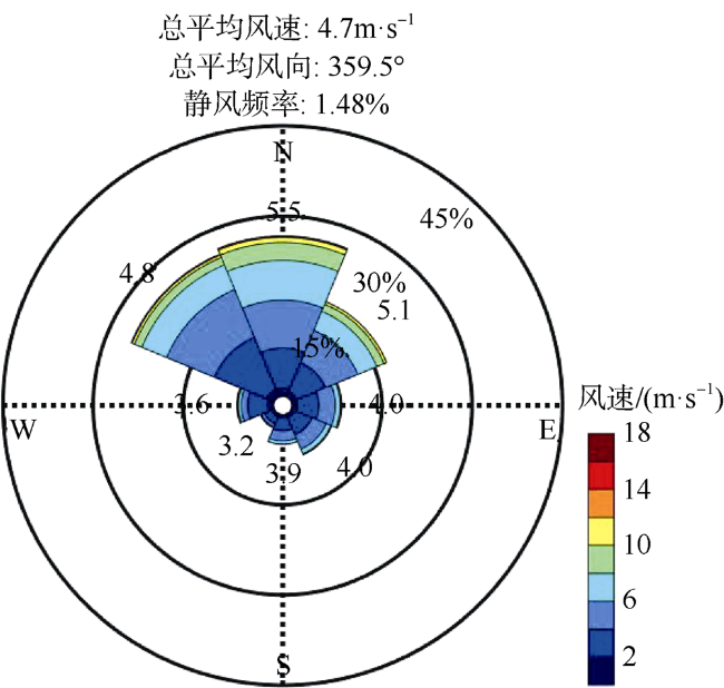
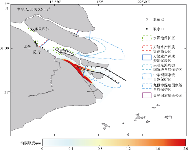
The drift and diffusion of oil film after the oil spill accident will pollute the surrounding waters, and environmental sensitive protection targets. The study of oil film drift and diffusion after oil spill accident can provide theoretical guidance for the treatment of oil spill accident. Coupling the oil spill drift and diffusion module, the estuarine and coastal three-dimensional hydrodynamic model ECOM-si (semi-implicit estuarine, costal and ocean Model) was used to simulate and analyzed the drift and diffusion of oil film after the oil spill accident at the Baosteel wharf in the Changjiang Estuary, and its impact on the environmental sensitive protection targets in this paper. Based on the measured wind speed and direction data at weather station on the Chongming eastern shola in the Changjiang Estuary, the prevailing wind and unfavorable wind affecting the oil spill drift are given. Forced by the monthly mean river discharge of 11700 m³·s-1, prevailing wind, three unfavorable winds and tide in January, the horizontal distribution of oil film, time of the oil film reaching and leaving the water intakes of four reservoirs and drinking water source protection areas, and other environmental sensitive protection targets, duration and maximum oil film thickness of oil film after the oil spill accident at the Baosteel wharf was numerically simulated and analyzed in detail. After the oil spill accident, the oil film oscillates upstream and downstream with the flood and ebb current, meanwhile the runoff transports the oil film to the sea, and the wind makes the oil film drift towards the wind direction. Under the action of the prevailing wind, northerly wind of 5.6 m³·s-1, the oil film drifts and diffuses downstream along the south coast of the Changjiang Estuary, and a small part enters the south side of the North Passage. Under the unfavorable wind, southeasterly wind of 4.0 m³·s-1, the oil film drifts in the northwest and accumulates on the north coast of the South Branch. Forced by the runoff, it is transported downstream on the middle and north side of the South Branch and the North Channel. Under the unfavorable wind, northwesterly wind of 4.8 m³·s-1, it weakens the impact on the sensitive targets upstream of the oil spill accident site and the ones in the North Channel, outside Chongming eastern shoal, and aggravates the impact on the environmental sensitive protection targets in the North Channel and South Passage. Under the unfavorable wind, southwesterly wind of 3.2 m³·s-1, most of the oil film drifts and diffuses downstream on the middle and north side of the North Channel, and a small part of the oil film is on the middle and north side of the North Passage. It weakens the impact on environmental sensitive targets upstream of the oil spill accident site and the downstream ones in the South Channel and South Passage, and aggravates the impact on the sensitive targets in the North Channel and outside Chongming eastern shoal. The distribution of oil film and its impact on the environmental sensitive protection targets are significantly different under the force of different wind directions, indicating that wind plays a very important role in oil film drift and diffusion.
GU Jinghua , ZHU Jianrong , JIN Zhi . Numerical simulation of oil film drift and diffusion after oil spill accident at the Baosteel wharf in the Changjiang Estuary[J]. Journal of Tropical Oceanography, 2022 , 41(6) : 159 -170 . DOI: 10.11978/2022065
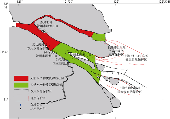
表1 长江口环境敏感保护目标Tab. 1 Environmental sensitive protection targets in the Changjiang Estuary |
| 序号 | 保护目标名称 | 保护目标级别 |
|---|---|---|
| 1 | 长江刀鲚国家级水产种质资源保护区 | 国家级 |
| 2 | 青草沙饮用水水源保护区 | 一级保护区、二级保护区 |
| 3 | 陈行饮用水水源保护区 | 一级保护区、二级保护区 |
| 4 | 长江太仓浏河饮用水水源保护区 | 一级保护区、二级保护区 |
| 5 | 东风西沙饮用水水源保护区 | 一级保护区、二级保护区 |
| 6 | 上海吴淞炮台湾国家湿地公园 | 国家级 |
| 7 | 上海崇明东滩鸟类国家级自然保护区 | 国家级 |
| 8 | 上海九段沙湿地国家级自然保护区 | 国家级 |
| 9 | 上海市长江口中华鲟省级自然保护区 | 省级 |
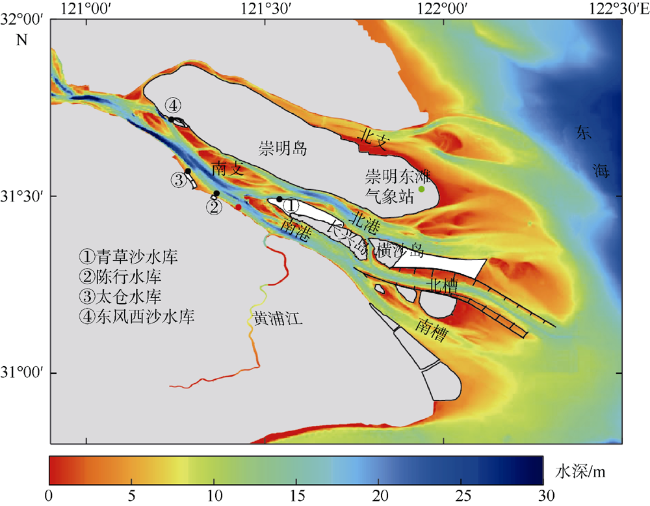
图1 长江口形-势图及上海港宝钢原料区域码头溢油事故泄漏点基于国家测绘地理信息局标准地图服务网站下载审图号为GS(2016)2556 标准地图制作。图中绿点为崇明东滩气象站; 红点为泄漏点; 黑点为水库取水口 Fig. 1 Sketch map of the Changjiang Estuary, and the site of oil leakage accident at the Baosteel raw material regional wharf of the Shanghai Port. The green dot marks the weather station at the Chongming eastern shoal; the red dot represents the oil leakage point, black dots stand for the water intakes of the reservoirs |
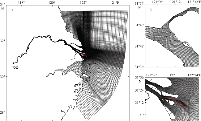
图3 模型计算范围和网格(a)以及局部放大的南北支分汊口附近网格(b)和南支口门附近网格(c)红线为深水航道导堤和丁坝。基于国家测绘地理信息局标准地图服务网站下载审图号为GS(2016)2556标准地图制作 Fig. 3 Model calculation domain and grids (a), and the enlarged view of grids near the bifurcation between the South Branch and North Branch (b) and near the mouth of the South Branch. The red lines are the guide dikes and groins of the Deepwater Channel |
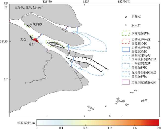
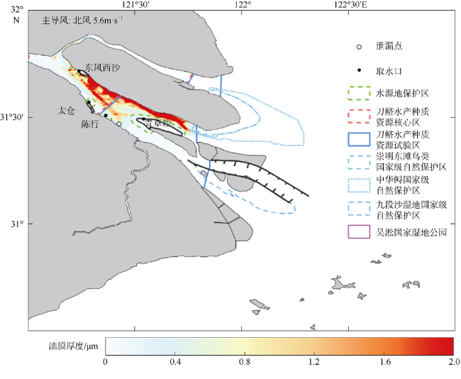
图5 溢油事故后3小时油膜分布基于国家测绘地理信息局标准地图服务网站下载审图号为GS(2016)2556 标准地图制作 Fig. 5 Distribution of oil film thickness after 3 hours of the oil spill accident |
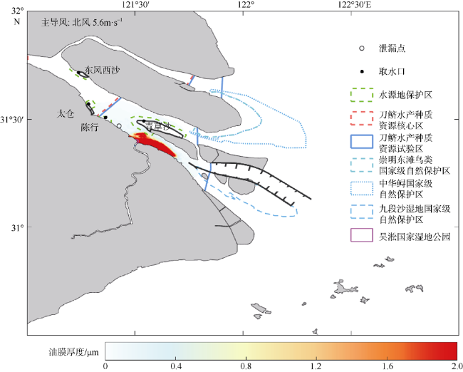
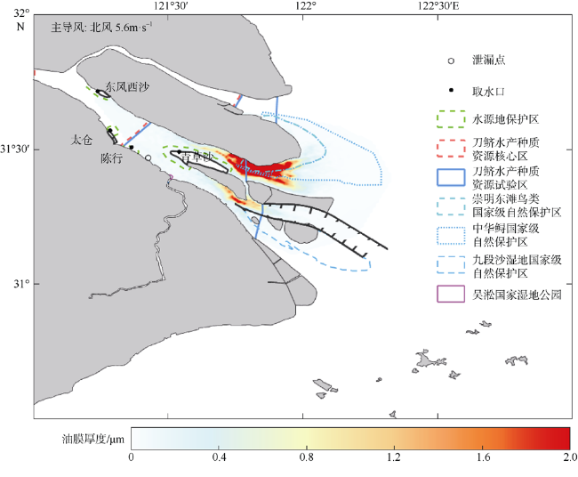
图6 溢油事故后24小时油膜分布基于国家测绘地理信息局标准地图服务网站下载审图号为GS(2016)2556 标准地图制作 Fig. 6 Distribution of oil film thickness after 24 hours of the oil spill accident |
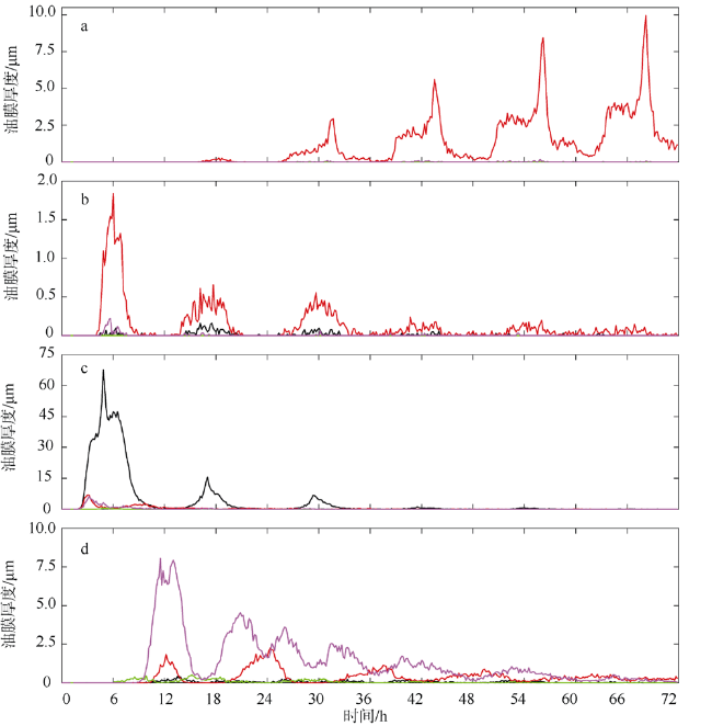
图8 油膜厚度在东风西沙水库取水口(a)、太仓水库取水口(b)、陈行水库取水口(c)和青草沙水库取水口(d)随时间变化情况黑线: 主导风(北风); 红线: 不利风向(东南风); 绿线: 不利风向(西北风); 紫线: 不利风向(西南风) Fig. 8 Temporal variation of oil film thickness at the water intakes of the Dongfengxisha reservoir (a), Taicang reservoir (b), Chenhang reservoir (c) and Qingcaosha reservoir. Black line: prevailing wind (northerly wind); red line: unfavorable wind direction (southeasterly wind); green line: unfavorable wind direction (northwesterly wind); purple line: unfavorable wind direction (southwesterly wind) |
| [1] |
陈士谦, 朱建荣, 2012. 鸭绿江公路大桥溢油漂移扩散三维数值模拟[J]. 华东师范大学学报(自然科学版), (6): 46-56.
|
| [2] |
陈义中, 朱建荣, 陈昞睿, 等, 2006. 渤海原油码头溢油漂移扩散的数值模拟[J]. 华东师范大学学报(自然科学版), (6): 25-33.
|
| [3] |
傅利辉, 朱建荣, 陈昞睿, 等, 2008. 崇启大桥建成后流场变化及溢油的数值模拟. 华东师范大学学报(自然科学版), (4): 114-123.
|
| [4] |
郭运武, 刘栋, 钟宝昌, 等, 2008. 风对河道溢油扩展、漂移影响的实验研究[J]. 水动力学研究与进展, 23(4): 446-452.
|
| [5] |
李大鸣, 陈海舟, 付庆军, 2008. 海上溢油数学模型的研究与应用[J]. 哈尔滨工程大学学报, 29(12): 1291-1297.
|
| [6] |
刘栋, 林卫青, 钟宝昌, 等, 2006. 感潮河道溢油扩展、漂移特性实验[J]. 水动力学研究与进展, 21(6): 744-751.
|
| [7] |
娄安刚, 王学昌, 孙长青, 等, 2001. 胶州湾海面溢油轨迹的数值模拟[J]. 黄渤海海洋, 19(1): 1-8.
|
| [8] |
娄厦, 刘曙光, 2008. 溢油模型理论及研究综述[J]. 环境科学与管理, 33(10): 33-37, 61.
|
| [9] |
孙宝楠, 杨永增, 于顺, 等, 2010. 基于分析法经典溢油蒸发模型的改进[J]. 海洋科学进展, 28(3): 364-371.
|
| [10] |
孙长青, 赵可胜, 郭耀同, 2003. 渤海湾海面溢油数值计算[J]. 海洋科学, 27(11): 63-67.
|
| [11] |
张和庆, 李福娇, 2001. 近海海面油类漂流扩散的研究和预测实践[J]. 热带气象学报, 17(1): 83-89.
|
| [12] |
|
| [13] |
|
| [14] |
|
| [15] |
|
| [16] |
|
| [17] |
|
| [18] |
|
| [19] |
|
| [20] |
|
/
| 〈 |
|
〉 |
