
Journal of Tropical Oceanography >
Quantitative analysis of geological environment stability of the Zhongsha Atoll based on K-means clustering AHP model
Copy editor: YIN Bo
Received date: 2022-04-08
Revised date: 2022-05-31
Online published: 2022-06-16
Supported by
Open Project of Hainan Key Laboratory of Marine Geological Resources and Environment(HNHYDZZYHJKF003)
Geological Tectonic research of South China sea(T100731)
Natural Science Foundation of China(42176081)
Natural Science Foundation of China(42174110)
Key Special Project for Introduced Talents Team of Southern Marine Science and Engineering Guangdong Laboratory (Guangzhou)(GML2019ZD0204)
Hainan Provincial Natural Science Foundation of China(2021JJLH0047)
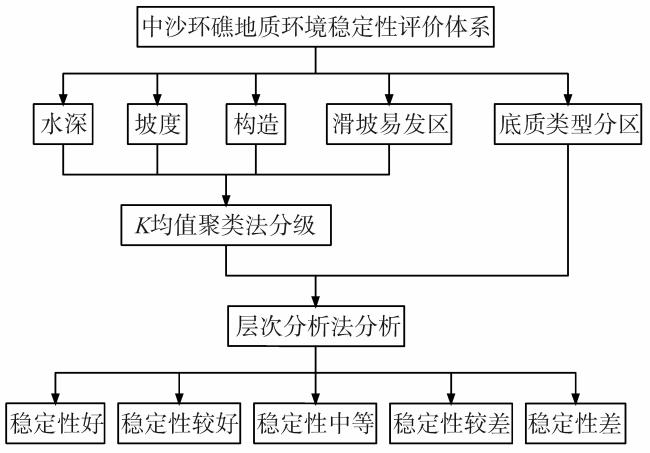
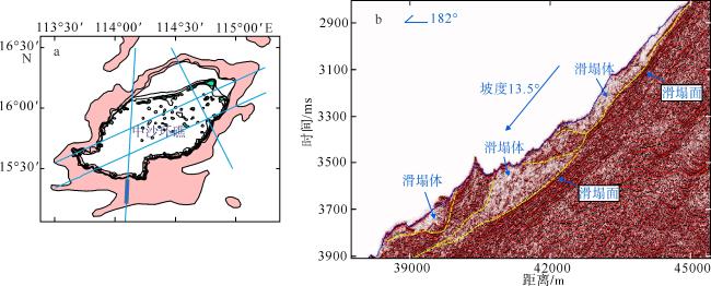
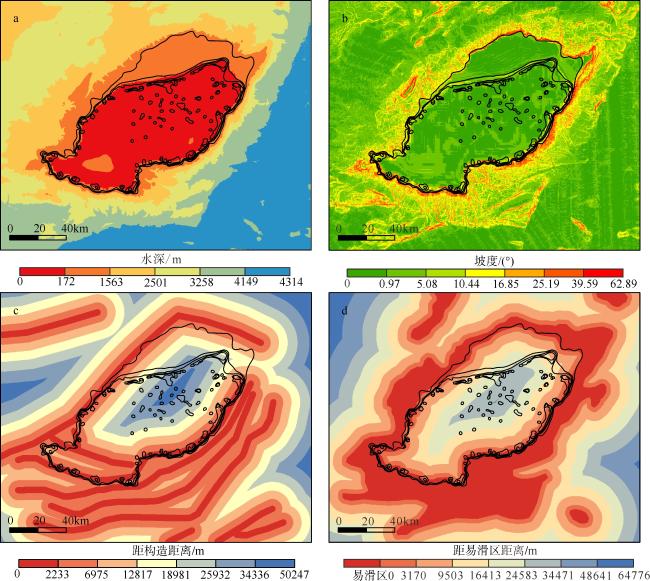
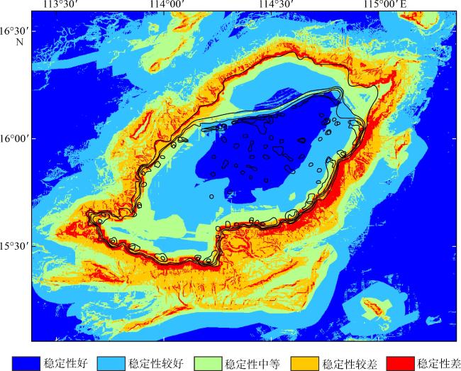
The Zhongsha Atoll is in the center of the South China Sea, and is a key location that connects the Dongsha, Xisha and Nansha Islands. This paper is based on the survey data of the Zhongsha Atoll topography, geological sampling, and multi-channel seismic profiles. We selected five influencing factors of water depth, sediment type, structural distance, landslide-prone area, and slope, and used the K-means clustering algorithm and analytic hierarchy process method to quantitatively analyze the stability of the Zhongsha Atoll. The study area was divided into five grades of stability: good, fair, medium, poor, and worse. We discussed the influence of different factors affecting the stability of Zhongsha Atoll. The deposition type, slope, and water depth are the main factors that affect the stability of the platform. The slope’s stability around the platform is mainly controlled by the factors such as slope, structure, and landslide-prone areas. However, the slope factor in the deep-water area outside the slope around the platform has the largest contribution. Overall, the stability of the north and west of the atoll is better than the east and south, in addition, the stability of the platform and the deep-water area outside the slope around the platform is the best. The evaluation results can provide basic geological services for development and planning, submarine pipeline engineering, disaster prevention and mitigation in the study area.
QIN Maogang , LONG Genyuan , LI Haiyun , HUANG Haibo , CHEN Wanli , CHEN Wen . Quantitative analysis of geological environment stability of the Zhongsha Atoll based on K-means clustering AHP model[J]. Journal of Tropical Oceanography, 2023 , 42(2) : 113 -123 . DOI: 10.11978/2022072
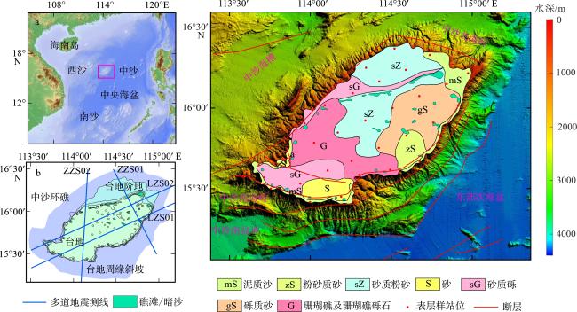
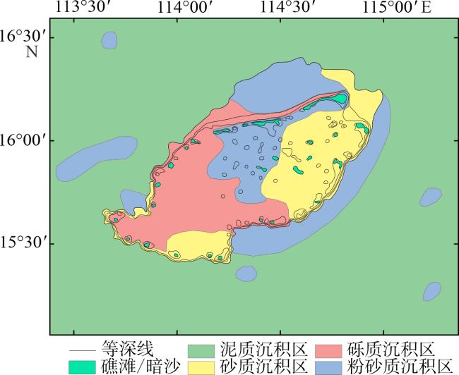
图1 研究区地理位置及底质类型图a. 区域背景图。该图基于标准地图服务网站下载的审图号为GS(2021)5447的标准地图制作, 底图无修改。图中红色方框为研究区范围; b. 多道地震测线位置; c. 中沙环礁底质类型图, 改自陈俊锦等(2022) Fig. 1 Geographic map and substrate type. (a) regional background of the South China Sea; (b) multi-channel seismic profiles location; (c) substrate type map of the Zhongsha Atoll, from Chen et al (2022) |
表1 评价因子相关系数统计表Tab. 1 Statistics table of evaluation factor correlation coefficient |
| 水深 | 坡度 | 构造缓冲区 | 滑坡易发区缓冲区 | 底质类型分区 | |
|---|---|---|---|---|---|
| 水深 | / | / | / | / | / |
| 坡度 | 0.079 | / | / | / | / |
| 构造缓冲区 | 0.236 | 0.074 | / | / | / |
| 滑坡易发区缓冲区 | 0.009 | 0.000 | 0.071 | / | / |
| 底质类型分区 | -0.063 | -0.062 | -0.031 | -0.046 | / |
注: / 表示无数据 |
表2 标度及其含义Tab. 2 Scale and its implications |
| 标度值 | 含义 |
|---|---|
| 1 | B2与B1同等重要 |
| 3 | B2比B1稍微重要 |
| 5 | B2比B1明显重要 |
| 7 | B2比B1强烈重要 |
| 9 | B2比B1极端重要 |
| 2, 4, 6, 8 | 分别表示相邻数字判断的中值 |
表3 各评价因子组合权重Tab. 3 The weight of each evaluation factor combination |
| 影响因子 | 因子权重 | 级别 | 级别权重 | 组合权重 | 影响因子 | 因子权重 | 级别 | 级别权重 | 组合权重 |
|---|---|---|---|---|---|---|---|---|---|
| 3 | 0.0775 | 0~172 | 0.0699 | 0.0054 | 滑坡易发区 | 0.2459 | 易滑区 | 0.3267 | 0.0803 |
| 172~1563 | 0.2905 | 0.0225 | 0~3170 | 0.2273 | 0.0559 | ||||
| 1563~2501 | 0.2596 | 0.0201 | 3170~9503 | 0.1568 | 0.0386 | ||||
| 2501~3258 | 0.2150 | 0.0167 | 9503~16413 | 0.1077 | 0.0265 | ||||
| 3258~4149 | 0.1030 | 0.0080 | 16413~24583 | 0.0734 | 0.0180 | ||||
| 4149~4314 | 0.0620 | 0.0048 | 24583~34471 | 0.0498 | 0.0122 | ||||
| 沉积物类型 | 0.0675 | 砾质沉积 | 0.4889 | 0.0330 | 34471~48641 | 0.0340 | 0.0084 | ||
| 砂质沉积 | 0.3079 | 0.0208 | 48641~64776 | 0.0243 | 0.0060 | ||||
| 粉砂沉积 | 0.1531 | 0.0103 | 坡度 | 0.5142 | 0~0.97 | 0.0318 | 0.0164 | ||
| 泥质沉积 | 0.0501 | 0.0034 | 0.97~5.08 | 0.0462 | 0.0238 | ||||
| 构造 | 0.0949 | 0~2233 | 0.3503 | 0.0332 | 5.08~10.44 | 0.0697 | 0.0358 | ||
| 2233~6975 | 0.2375 | 0.0225 | 10.44~16.85 | 0.1056 | 0.0543 | ||||
| 6975~12817 | 0.1590 | 0.0151 | 16.85~25.19 | 0.1589 | 0.0817 | ||||
| 12817~18981 | 0.1056 | 0.0100 | 25.19~39.59 | 0.2375 | 0.1221 | ||||
| 18981~25932 | 0.0697 | 0.0066 | 39.59~62.89 | 0.3503 | 0.1801 | ||||
| 25932~34336 | 0.0462 | 0.0044 | |||||||
| 34336~50247 | 0.0317 | 0.0030 |
| [1] |
陈俊锦, 张经纬, 刘时桥, 等, 2022. 南海中沙群岛海域表层沉积物粒度特征及其输运趋势[J]. 海洋地质与第四纪地质, 42(2): 15-27.
|
| [2] |
陈梅, 夏真, 刘文涛, 等, 2022. 南海宣德环礁东南海域地质灾害特征[J]. 热带海洋学报, 41(2): 103-111.
|
| [3] |
海南省地方志办公室, 2010. 海南省志. 自然地理志[M]. 海南出版社. (in Chinese)
|
| [4] |
胡进军, 徐长琦, 谢礼立, 等, 2018. 南海岛礁场地地震稳定性研究中的关键问题探讨[J]. 地震工程学报, 40(2): 279-287.
|
| [5] |
金宗川, 2018. 钙质砂的休止角研究与工程应用[J]. 岩土力学, 39(7): 2583-2590.
|
| [6] |
李军, 周成虎, 2003. 基于栅格GIS滑坡风险评价方法中格网大小选取分析[J]. 遥感学报, (2): 86-92.
|
| [7] |
李学杰, 王大伟, 吴时国, 等, 2017. 三沙海底峡谷识别与地貌特征分析[J]. 海洋地质与第四纪地质, 37(3): 28-36.
|
| [8] |
黎雨晗, 黄海波, 丘学林, 等, 2020. 中沙海域的广角与多道地震探测[J]. 地球物理学报, 63(4): 1523-1537.
|
| [9] |
刘韶, 1987. 中沙群岛礁湖沉积特征的探讨—兼论礁湖的地貌单元[J]. 海洋学报(中文版), 9(6): 794-797. (in Chinese)
|
| [10] |
任恒妮, 2019. 大数据K-means聚类算法的研究与应用[J]. 信息技术, 43(11): 20-23.
|
| [11] |
王千, 王成, 冯振元, 等, 2012. K-means聚类算法研究综述[J]. 电子设计工程, 20(7): 21-24.
|
| [12] |
吴夙慧, 成颖, 郑彦宁, 等, 2011. K-means算法研究综述[J]. 现代图书情报技术, 27(5): 28-35.
|
| [13] |
徐建华, 2002. 现代地理学中的数学方法[M]. 北京: 高等教育出版社:229-230.
|
| [14] |
徐子英, 汪俊, 高红芳, 等, 2020. 中沙地块南部断裂发育特征及其成因机制[J]. 中国地质, 47(5): 1438-1446.
|
| [15] |
杨马陵, 魏柏林, 2020. 南海海域地震海啸潜在危险的探析[J]. 灾害学, 20(3): 41-47.
|
| [16] |
余克服, 蒋明星, 程志强, 等, 2004. 涠洲岛42年来海面温度变化及其对珊瑚礁的影响[J]. 应用生态学报, 15(3): 506-510.
|
| [17] |
詹文欢, 詹美珍, 孙宗勋, 等, 2010. 雷州半岛西南部珊瑚礁礁体结构与场地稳定性分析[J]. 热带海洋学报, 29(3): 151-154.
|
| [18] |
赵焕庭, 王丽荣, 宋朝景, 2014. 南海珊瑚礁地貌模型研究[J]. 海洋学报, 36(9): 112-120.
|
| [19] |
周天伦, 曾超, 范晨, 等, 2021. 基于快速聚类-信息量模型的汶川及周边两县滑坡易发性评价[J]. 中国地质灾害与防治学报, 32(5): 137-150.
|
| [20] |
|
| [21] |
|
| [22] |
|
| [23] |
|
| [24] |
|
| [25] |
|
| [26] |
|
| [27] |
|
/
| 〈 |
|
〉 |
