
Journal of Tropical Oceanography >
Analysis of shallow surface fine geological characteristics and hazard factors of the seabed in the northern part of Dongsha, South China Sea based on AUV data
Copy editor: YAO Yantao
Received date: 2022-02-14
Revised date: 2022-06-14
Online published: 2022-06-17
Supported by
National Natural Science Foundation of China(42176083)
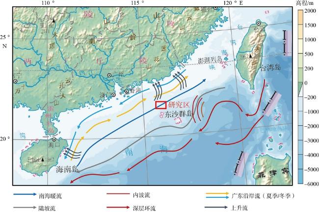
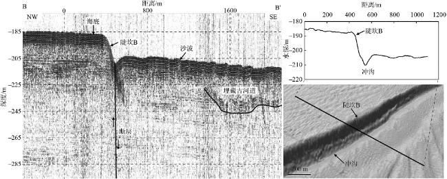
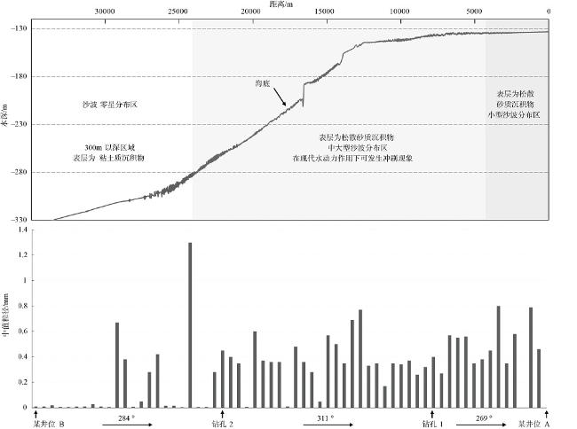
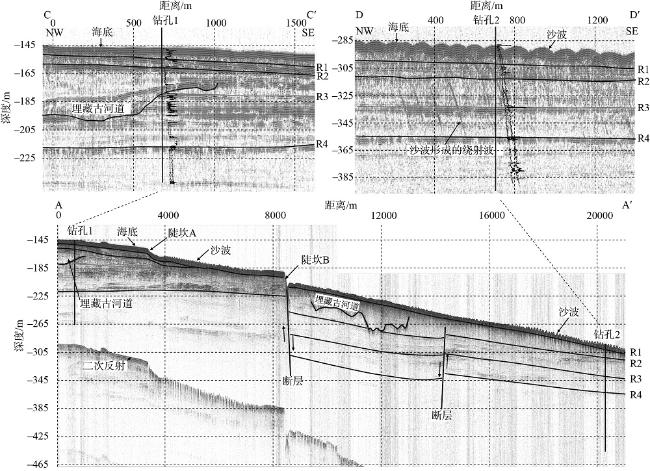
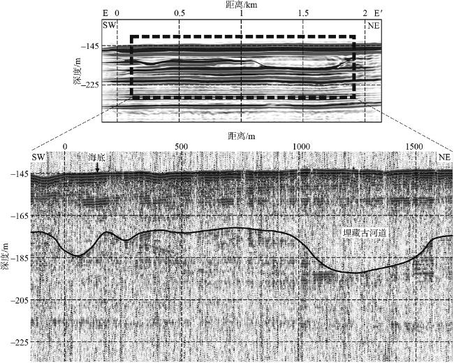
A comprehensive understanding of the geological characteristics of shallow strata of seabed is the basis for identifying and evaluating shallow marine geological hazards, which is of great significance to the development of marine resources and marine engineering construction. Multiple oil and gas fields are being explored and developed in northern Dongsha, South China Sea. However, there is a lack of systematic analysis of the fine geological characteristics of the shallow strata in this place. Based on the diverse data of AUV (autonomous underwater vehicle), multi-beam, AUV shallow stratum profile, 2D seismic data and sediment test, the factors of shallow strata geological hazards were identified and their risks were evaluated in the area of 100~400m water depth in northern Dongsha, South China Sea. The survey found that the seabed surface sediments in the study area were generally relatively stable, and several micro-geomorphologies of the seabed, such as sand waves, steep steps and gullies developed. Shallow gas below the seabed was not observed, and numerous paleovalleys are developed. Significant spatial differences are featured in the shape and distribution characteristics of seabed sand waves. The sand waves with wave height greater than 1m are mainly distributed in the depths of 134~143m, 168~187m and 205m, they can move positions under modern dynamic conditions. The observation results show that the development of seabed sand waves is related to the process of internal waves. The steep steps are more than 20°, which is considered to be related to the faults running through the shallow strata.
Key words: AUV; geological characteristics; geohazard factors; South China Sea; sand waves
LI Yanjie , ZHU Yousheng , CHEN Guanjun , WANG Shu , WANG Weiwei . Analysis of shallow surface fine geological characteristics and hazard factors of the seabed in the northern part of Dongsha, South China Sea based on AUV data[J]. Journal of Tropical Oceanography, 2023 , 42(1) : 114 -123 . DOI: 10.11978/2022025
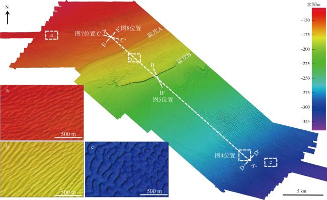
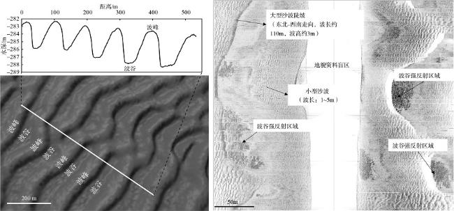
图3 研究区地形及海底沙波的分布Fig. 3 Topography and distribution of seabed sand waves in the study area |
表1 海底沙波随水深分布的规律Tab. 1 Distribution rule of seabed sand waves with water depth |
| 深度范围/m | 280~292 | 230~280 | 205~220 | 187~190 | 168~187 | 151~155 | 143~146 | 134~143 | 131~134 |
|---|---|---|---|---|---|---|---|---|---|
| 波长/m | 50~150 | 65~220 | 50~60 | <10 | 50~110 | <10 | <10 | 40~130 | <10 |
| 波高/m | 2.3~5.1 | 1.3~5.1 | 1.3~1.5 | <0.5 | 1.3~3.0 | <0.5 | <0.5 | 1~2.8 | <0.4 |
| [1] |
陈俊仁, 李廷桓, 1993. 南海地质灾害类型与分布规律[J]. 地质学报, 67(1): 76-85.
|
| [2] |
陈业伟, 宋海斌, 关永贤, 等, 2018. 南海东沙海域网状沙丘的发现及其成因探讨[J]. 地球物理学报, 61(3): 1013-1024.
|
| [3] |
冯文科, 黎维峰, 1994. 南海北部海底沙波地貌[J]. 热带海洋, 13(3): 39-46.
|
| [4] |
冯湘子, 朱友生, 2020. 南海北部陵水陆坡重力流沉积调查与分析[J]. 海洋地质与第四纪地质, 40(5): 25-35.
|
| [5] |
冯志强, 刘宗惠, 柯胜边, 1994. 南海北部地质灾害类型及分布规律[J]. 中国地质灾害与防治学报, 5(S1): 171-180.
|
| [6] |
冯志强, 冯文科, 薛万俊, 等, 1996. 南海北部地质灾害及海底工程地质条件评价[M]. 南京: 河海大学出版社.
|
| [7] |
耿明会, 宋海斌, 关永贤, 等, 2017. 南海北部东沙海域巨型水下沙丘的分布及特征[J]. 地球物理学报, 60(2): 628-638.
|
| [8] |
何健, 梁前勇, 马云, 等, 2018. 南海北部陆坡天然气水合物区地质灾害类型及其分布特征[J]. 中国地质, 45(1): 15-28.
|
| [9] |
寇养琦, 杜德莉, 1994. 南海北部陆架第四纪古河道的沉积特征[J]. 地质学报, 68(3): 268-277.
|
| [10] |
李亮, 陈忠, 刘建国, 等, 2014. 南海北部表层沉积物类型及沉积环境区划[J]. 热带海洋学报, 33(1): 54-61.
|
| [11] |
李振, 彭华, 马秀敏, 等, 2018. 琼州海峡古河道及其工程地质评价[J]. 工程地质学报, 26(4): 1017-1024.
|
| [12] |
刘丛舒, 丁巍伟, 殷绍如, 等, 2019. 南海北部陆坡区海底峡谷地貌、沉积特征及控制因素[J]. 海洋学研究, 37(2): 28-43.
|
| [13] |
刘乐军, 傅命佐, 李家钢, 等, 2014. 荔湾3-1 气田海底管道深水段地质灾害特征[J]. 海洋科学进展, 32(2): 162-174.
|
| [14] |
刘鑫, 石要红, 马胜中, 2013. 南海北部海域1∶100万灾害地质因素分布图编制[J]. 地理空间信息, 11(3): 151-153, 162.
|
| [15] |
刘铮, 陈端新, 朱友生, 等, 2021. 基于水下自主航行器(AUV)的神狐峡谷谷底块体搬运沉积特征及其对深水峡谷物质输运过程的指示[J]. 海洋地质与第四纪地质, 41(2): 13-21.
|
| [16] |
栾锡武, 彭学超, 王英民, 等, 2010. 南海北部陆架海底沙波基本特征及属性[J]. 地质学报, 84(2): 233-245.
|
| [17] |
栾锡武, 张亮, 彭学超, 2011. 南海北部东沙海底冲蚀河谷及其成因探讨[J]. 中国科学 D辑: 地球科学, 41(11): 1636-1646.
|
| [18] |
栾锡武, 孙钿奇, 彭学超, 2012. 南海北部陆架南北卫浅滩的成因及油气地质意义[J]. 地质学报, 86(4): 626-640.
|
| [19] |
罗进华, 朱培民, 2019. 琼东南盆地陆坡区重力流沉积体系超高精度解析[J]. 地质科技情报, 38(6): 42-50.
|
| [20] |
马云, 孔亮, 梁前勇, 等, 2017. 南海北部东沙陆坡主要灾害地质因素特征[J]. 地学前缘, 24(4): 102-111.
|
| [21] |
彭学超, 吴庐山, 崔兆国, 等, 2006. 南海东沙群岛以北海底沙波稳定性分析[J]. 热带海洋学报, 25(3): 21-27.
|
| [22] |
舒业强, 王强, 俎婷婷, 2018. 南海北部陆架陆坡流系研究进展[J]. 中国科学 D辑: 地球科学, 48(3): 276-287.
|
| [23] |
王大伟, 曾凡长, 王微微, 等, 2022. 海底冲沟——深水沉积输运系统的“毛细血管”[J]. 地球科学进展, 37(4): 331-343.
|
| [24] |
王尚毅, 李大鸣, 1994. 南海珠江口盆地陆架斜坡及大陆坡海底沙波动态分析[J]. 海洋学报, 16(6): 122-132. (in Chinese)
|
| [25] |
王星星, 蔡峰, 孙治雷, 等, 2021. 南海北部东沙海底峡谷沉积演化过程及其地质意义[J]. 地球科学, 46(3): 1023-1037.
|
| [26] |
夏真, 郑涛, 庞高存, 1999. 南海北部海底地质灾害因素[J]. 热带海洋, 18(4): 91-95.
|
| [27] |
叶银灿, 2011. 海洋灾害地质学发展的历史回顾及前景展望[J]. 海洋学研究, 29(4): 1-7.
|
| [28] |
周川, 范奉鑫, 栾振东, 等, 2013. 南海北部陆架主要地貌特征及灾害地质因素[J]. 海洋地质前沿, 29(1): 51-60.
|
| [29] |
朱友生, 2017. 南海北部陆架边缘区域地质灾害类型特征及分布规律[J]. 中国海上油气, 29(3): 107-115.
|
| [30] |
|
| [31] |
|
| [32] |
|
/
| 〈 |
|
〉 |
