
Journal of Tropical Oceanography >
A study of the effect of shore platform morphology on coastal erosion of rocky cliffs in the Wucaiwan Bay, E’man, Hainan Island
Received date: 2023-11-08
Revised date: 2023-12-04
Online published: 2023-12-26
Supported by
National Natural Science Foundation of China(42206216)
Hainan Provincial Natural Science Foundation of China(421QN0978)
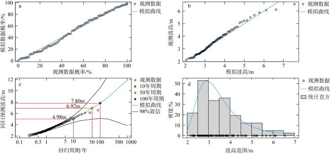
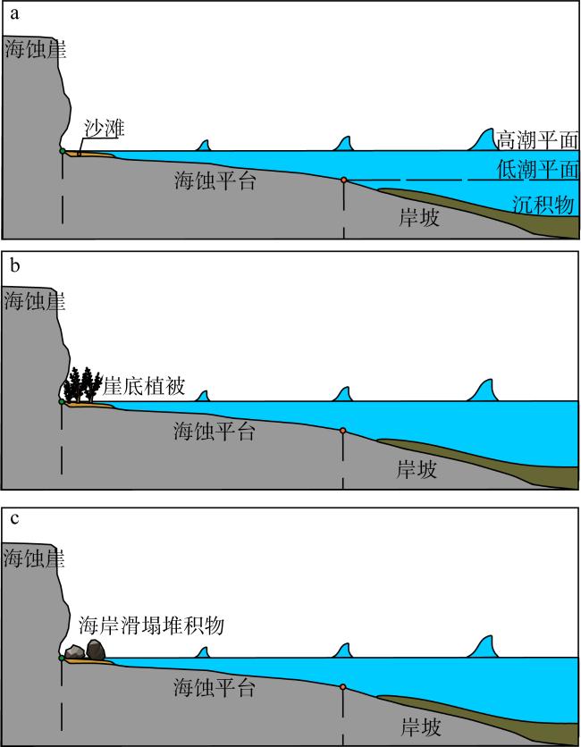
The intensification of extreme wave marine hazard induced by global ocean change is very likely to accelerate the geo-hazard risk of cliff erosion in Hainan Island. Shore platforms are expected to effectively attenuate wave energy approaching the shore and consequently reduce the erosive impact of extreme waves on cliff. Shore platforms are commonly observed in volcanic rocky coasts on NW Hainan Island, providing an ideal natural laboratory to evaluate the effect of shore platform morphology on cliff erosion. This study employs the Wucaiwan Bay rocky coastline in the E’man Town, Danzhou City, Hainan Island as the study area. Time-lapsed marine remote sensing images revealed the cliff erosion rate is about 0.26 m·a-1 in the last decade in the area. Physical oceanography analysis suggested a maximum significant wave height of 7.8 m could be expected visiting the area in a 100-years return level. The geomorphological characteristics of the sloping shore platform and the rock strength of cliffs were further surveyed via coastal geomorphological approaches. Numerical computation outputs suggest the shore platforms is capable of reducing the wave erosional forces on cliff by over 80% under future extreme wave conditions. This study further discusses the natural coastal protection from sediment beaches, vegetations and in situ deposition of eroded boulders at rock cliff foot.
Key words: shore platform; cliff erosion; basalt coast; numerical computation; Hainan Island
ZHAO Zhongwei , WU Lingyun , GAO Weijian , LI Wei . A study of the effect of shore platform morphology on coastal erosion of rocky cliffs in the Wucaiwan Bay, E’man, Hainan Island[J]. Journal of Tropical Oceanography, 2024 , 43(5) : 106 -115 . DOI: 10.11978/2023169
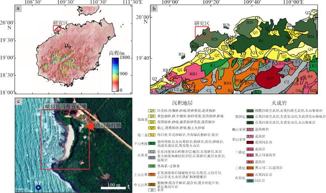
图1 研究区域位置及地质图a. 海南岛数字高程模型渲染图, 数据源自先进陆地观测卫星获取的海南岛12.5m数字高程模型, 审图号为GS(2019)3266; b. 海南岛西北部区域地质图, 该图基于海南省标准地图服务网站下载的审图号为琼S(2021)007标准地图制作; c. 五彩湾海岸卫星遥感图, 数据源自谷歌地球(Google Earth), 图中红色方框是研究区范围示意; 蓝圈WP1标记 Fig. 1 The location and geological map of the study area. (a) DEM map of the Hainan Island, data sourced from ALOS with a spatial resolution of 12.5 m; (b) the geological map of the NW Hainan Island; (c) Google Earth satellite image of the Wucaiwan Bay, blue dot marks the position of wave analysis point in |
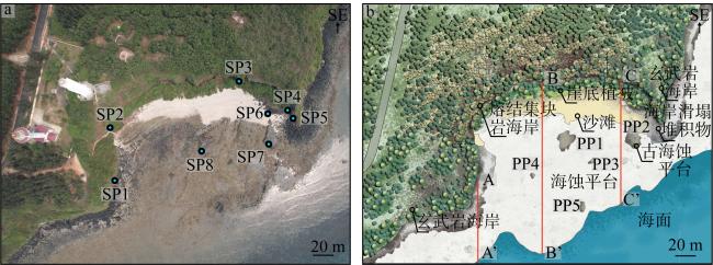
图2 五彩湾基岩海岸无人机航拍图及海岸地貌解释图a. SP1~SP8标记海岸岩石施密特锤测试点位置; b. PP1~PP5标记古海蚀平台发育位置, 3条红色直线为 Fig. 2 The aerial image of the Wucaiwan Bay rocky coast taken by UAV (unmanned aerial vehicle) and the interpreted coastal geomorphological map. (a) Sites SP1-SP8 locate where the Schmidt hammer tests were conducted; (b) sites PP1-PP5 mark positions where paleo-shore platform occurred, red lines are the transects represented in the wave height attenuation modelling in |
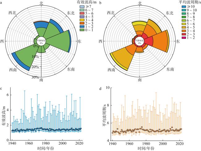
图3 五彩湾基岩海岸近岸历史波浪特征分析图a. 有效波高玫瑰花图; b. 平均波周期玫瑰花图; c. 前10%有效波高随年度变化图, 蓝色方块对应各年度第95百分位数所对应的有效波高数值; d. 前10%平均波周期随年度变化图, 橙色圆点对应各年度第95百分位数所对应的平均波周期数值 Fig. 3 Wave analysis plots of the nearshore historical wave properties in Wucaiwan Bay area. (a) Wave rose diagram of significant wave height; (b) wave rose diagram of mean wave period; (c) annual variation of upper 10 percentile significant wave height, blue squares represent the 95 percentile significant wave height of each year; (d) annual variation of upper 10 percentile mean wave period, orange circles represent the 95 percentile mean wave period of each year |
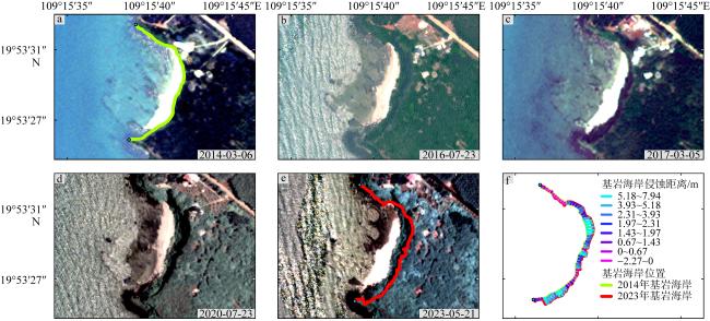
图5 五彩湾基岩海岸历史卫星图a~e分别采集自2014年3月6日和2023年5月21日之间; f. 海蚀崖侵蚀距离, 测算自图a (绿线)和图e (红线)中标记的海蚀崖位置 Fig. 5 Historical satellite images of the Wucaiwan Bay rocky coast. (a)-(e) were collected between 06/Mar/2014 and 21/May/2023; (f) cliff retreat distance calculated between rocky cliff positions interpreted in (a) and (e), marked in green and red, respectively |
表1 五彩湾基岩海岸野外施密特锤反弹测量平均值(RL)及其对应岩石单轴抗压强度(Sc)Tab. 1 Average Schmidt hammer rebound test values of the Wucaiwan Bay rocky coasts and their associated compressive strength Sc |
| 测试点编号 | 施密特锤平均反弹参数/mm | 海岸岩石的单轴抗压强度/Mpa | 测试点位置 |
|---|---|---|---|
| SP1 | 12 | 3.36 | 海蚀崖表面 |
| SP2 | 11 | 3.13 | 海蚀崖表面 |
| SP3 | 15 | 4.14 | 海蚀崖表面 |
| SP4 | 33 | 14.61 | 海蚀崖表面 |
| SP5 | 43 | 29.42 | 海蚀崖表面 |
| SP6 | 46 | 36.29 | 海蚀崖底部侵蚀滑塌堆积物 |
| SP7 | 14 | 3.86 | 古海蚀平台迎浪面 |
| SP8 | 46 | 36.29 | 古海蚀平台迎浪面 |
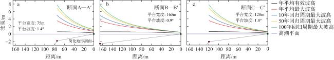
图6 海蚀平台发育影响下的波浪衰减模拟a. 断面A—A′ ; b. 断面B—B′; c. 断面C—C′。断面位置标记在 Fig. 6 Simulations of wave height attenuation travelling across shore platforms along transects A—A′ (a), B—B′ (b) and C—C′ (c), transects are located in |
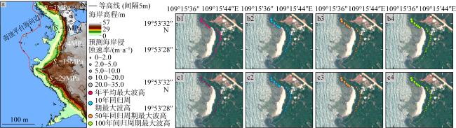
图7 五彩湾海蚀崖在未来极端波浪作用下的侵蚀后退速率预测a. 无人机测量 DEM, 图中Sc表示不同区域海岸岩石的单轴抗压强度; b1~b4为年平均最大波高、10年回归周期、50年回归周期和100年回归周期在近破波浪条件下的海岸侵蚀速率; c1~c4为在已破波浪条件下的海岸侵蚀速率 Fig. 7 Predicted cliff erosion rates of the Wucaiwan Bay rocky cliff under future extreme wave conditions. (a) DEM created by UAV, Sc values indicate rock cliff resistance strength at different coastal sectors; (b1) - (b4) predicted erosion rates induced by breaking waves using maximum wave heights of annual average, 10 years return level, 50 years return level and 100 years return level; (c1) - (c4) induced by broken waves |
表2 五彩湾海蚀崖在未来极端海洋条件下的侵蚀速率Tab. 2 Predicted cliff erosion rates of the Wucaiwan Bay rocky cliffs under future extreme waves |
| 波高工况 | 输入波 高/m | 海蚀平台衰减 后最大波高/m | 海蚀平台衰减后最小波高/m | 海蚀平台衰减后平均波高/m | 最大海蚀崖侵蚀速率/(m·a-1) | 最小海蚀崖侵蚀速率/(m·a-1) | 平均海蚀崖侵 蚀速率/(m·a-1) | 海蚀平台平均衰减效果/% | |
|---|---|---|---|---|---|---|---|---|---|
| 近破波浪 | |||||||||
| 年平均有效 | 0.61 | 0.37 | 0.24 | 0.26 | 0 | 0 | 0 | 57.38 | |
| 年平均最大 | 3.56 | 1.95 | 0.34 | 0.70 | 14.49 | 0.26 | 3.60 | 80.33 | |
| 10年回归周期最大 | 4.98 | 2.71 | 0.37 | 0.90 | 20.10 | 0.30 | 4.64 | 81.92 | |
| 50年回归周期最大 | 6.92 | 3.74 | 0.40 | 1.16 | 27.77 | 0.35 | 6.04 | 83.23 | |
| 100年回归周期最大 | 7.80 | 4.21 | 0.42 | 1.27 | 31.25 | 0.37 | 6.67 | 83.72 | |
| 已破波浪 | |||||||||
| 年平均有效 | 0.61 | 0.37 | 0.24 | 0.26 | 0 | 0 | 0 | 57.38 | |
| 年平均最大 | 3.56 | 1.95 | 0.34 | 0.70 | 5.24 | 0.10 | 1.30 | 80.33 | |
| 10年回归周期最大 | 4.98 | 2.71 | 0.37 | 0.90 | 19.39 | 0.29 | 4.47 | 81.92 | |
| 50年回归周期最大 | 6.92 | 3.74 | 1.16 | 0.40 | 26.79 | 0.34 | 5.83 | 83.23 | |
| 100年回归周期最大 | 7.80 | 4.21 | 0.41 | 1.27 | 30.15 | 0.36 | 6.44 | 83.72 | |
| [1] |
邸有鹏, 王全勇, 孙乐川, 2019. 海南岛邦塘湾海岸侵蚀演变及原因分析[J]. 工程与建设, 33(2): 155-156, 172.
|
| [2] |
樊祺诚, 孙谦, 李霓, 等, 2004. 琼北火山活动分期与全新世岩浆演化[J]. 岩石学报, 20(3): 533-544.
|
| [3] |
冯兴如, 李近元, 尹宝树, 等, 2018. 海南东方近岸海域海浪观测特征研究[J]. 热带海洋学报, 37(3): 1-8.
|
| [4] |
符启基, 沈金羽, 林才, 2012. 海南省笔架岭火山口及峨蔓湾地质遗迹景观开发初探[J]. 资源环境与工程, 26(6): 641-644.
|
| [5] |
韩孝辉, 吕剑泉, 陈文, 2018. 海南岛峨蔓火山海岸地质遗迹评价[J]. 华东地质, 39(2): 151-160.
|
| [6] |
黄心裕, 唐军, 王晓宇, 2022. 基于Prophet算法的海南近海波浪长时段时序分析与预测[J]. 海洋学报, 44(4): 114-121.
|
| [7] |
季荣耀, 罗宪林, 陆永军, 等, 2007. 海南岛海岸侵蚀特征及主因分析[C]// 第十三届中国海洋(岸)工程学术讨论会论文集. 北京: 海洋出版社: 374-377 (in Chinese).
|
| [8] |
李丽, 武兴, 郭雅, 2019. 海南岛西北部海岸线时空变化分析[J]. 中国地质调查, 6(2): 87-93.
|
| [9] |
石海莹, 2013. 海南岛沿岸海洋灾害特征及防御对策[J]. 海洋开发与管理, 30(12): 70-75 (in Chinese).
|
| [10] |
石海莹, 吕宇波, 冯朝材, 2018. 海南岛典型岸段侵蚀现状及特征分析[J]. 海洋环境科学, 37(3): 383-388.
|
| [11] |
侍茂崇, 高劲松, 陈波, 等, 2011. 洋浦港附近冬季潮、余流特征分析[J]. 海洋湖沼通报, (2): 1-6.
|
| [12] |
王颖, 周旅复, 1990. 海南岛西北部火山海岸的研究[J]. 地理学报, 45(3): 321-330.
|
| [13] |
文世勇, 王紫竹, 王涛, 等, 2020. 基于遥感技术的海南省海岸侵蚀现状与趋势评估[J]. 灾害学, 35(1): 138-143.
|
| [14] |
徐笑梅, 高抒, 周亮, 等, 2019. 海南岛东北部海岸极端波浪事件沉积记录[J]. 海洋学报, 41(6): 48-63.
|
| [15] |
杨文健, 赵波, 于红梅, 等, 2022. 琼北峨蔓地区火山地质与喷发历史[J]. 地震地质, 44(4): 859-875.
|
| [16] |
曾其爽, 1985. 海南岛西北部玄武岩海岸地貌研究[J]. 热带地貌, 6(2): 19-61.
|
| [17] |
赵勇伟, 李霓, 陈正全, 等, 2022. 海南峨蔓兵马角海岸火山地质特征与喷发灾害类型[J]. 地震地质, 44(2): 281-296.
|
| [18] |
庄克琳, 李广雪, 1999. 基岩海岸侵蚀数值研究进展[J]. 海洋地质动态, (11): 1-2 (in Chinese).
|
| [19] |
|
| [20] |
|
| [21] |
|
| [22] |
|
| [23] |
|
| [24] |
|
| [25] |
|
| [26] |
|
| [27] |
|
| [28] |
|
| [29] |
|
| [30] |
|
| [31] |
|
| [32] |
|
| [33] |
|
| [34] |
|
| [35] |
|
| [36] |
|
| [37] |
|
| [38] |
|
| [39] |
|
/
| 〈 |
|
〉 |
