
Journal of Tropical Oceanography >
Challenges and case analysis of deepwater engineering investigation in the South China Sea
Copy editor: SUN Cuici
Received date: 2024-03-14
Revised date: 2024-04-27
Online published: 2024-05-08
Supported by
National Key Research and Development Program Project(2022YFC2805503)
China National Offshore Oil and Gas Corporation Project (Detailed Survey of Lingshui 17-2 Gas Field Group Development Project Site)
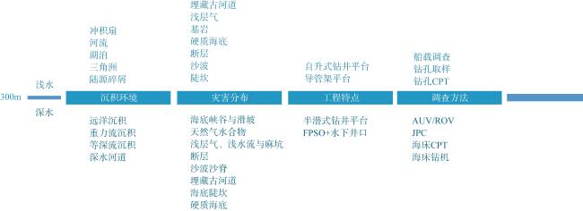
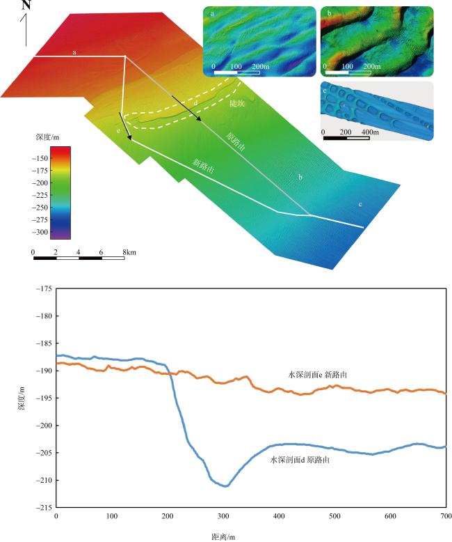
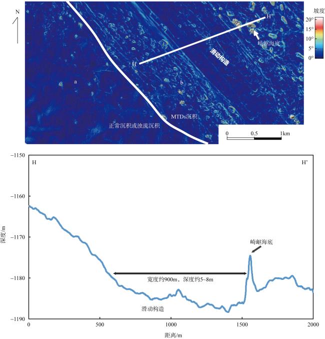
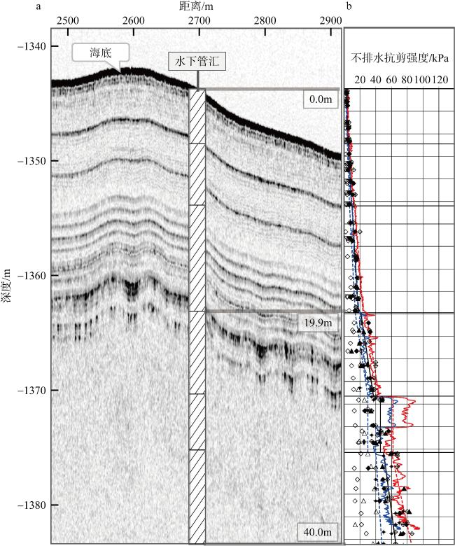
The marine engineering survey focuses on the geological hazards that threaten the marine engineering. In the process of moving towards the deep water, it has also been found that several unique geological phenomena, distinct from shallow water areas, have a certain impact on the positioning of drilling platforms, the design of jacket platforms and floating platforms, and the optimization of submarine pipeline and cable routes. Based on the results of many deepwater well site surveys and deep-water oil and gas field development project surveys, this paper expounds the characteristics of deep-water geological hazards, the methods of research and evaluation and the impact on marine engineering through the results of engineering geophysical survey, engineering geological survey and marine environmental survey, and provides a better idea for the investigation and design of deep-water marine engineering. The researches show that the deep water is widely developed with sand waves, scarps, hard seabed, faults, submarine canyons, mass transport deposits and other geological disaster phenomena. When conducting engineering geophysical survey, the use of autonomous underwater vehicle (AUV) and other survey methods to obtain centimeter resolution survey results can effectively reduce the observation period of seabed sand wave movement rate, and obtain more accurate water depth topographic data to support the marine engineering design. Combined with the shallow soil sample results and shallow profile results of the engineering geological survey, the seabed strata can be effectively divided and the slope stability analysis can be carried out, providing the design basis for the offshore engineering construction.
FENG Xiangzi , Li Yufei , Wang Weiwei , Wang Dawei . Challenges and case analysis of deepwater engineering investigation in the South China Sea[J]. Journal of Tropical Oceanography, 2025 , 44(1) : 200 -210 . DOI: 10.11978/2024058
表1 深水油气田工程勘察阶段划分(李家钢 等, 2013)Tab. 1 Basic process of deep-water oil-gas field engineering investigation (Li et al, 2013) |
| 勘察阶段 | 勘察工作内容与重点 | 勘察平台与技术手段 | 勘探比例尺 |
|---|---|---|---|
| 可研勘察 | 了解区域地形地貌与地质构造, 识别地质灾害 类型和特征, 评价构筑物地基的适宜性 | 收集历史资料, 辅以已有的地形地貌图, 补充 船载多波束、浅地层探测和表层/柱状取样 | 1:100 000 |
| ODP 勘察 | 初步查明水下井场、管道路由区的地形地貌、 工程地质条件, 提供设计所需的岩土参数及评价 地质灾害危害性。 | 深拖/AUV/ROV(remotely operated vehicle) 平台的多波束、侧扫声呐和浅地层 剖面为主, 辅以船载地震探测, 结合 部分钻探、原位测试和室内试验 | 1:2 000~1:10 000 |
| 基本设计勘察 | 查明浮式生产储油船 (floating production storage and offloading, FPSO)锚位、水下井口等的精细地形地貌、海底构筑物影响范围内岩土分布及其物理力学性质, 评价地质灾害风险 | 深拖/AUV/ROV 平台的多波束、侧扫声呐 和浅地层探测, 结合钻探、原位测试和室 内试验; 以及现场监测 | 1:500~1:2 000 |
| 施工勘察(包括施工勘察、运营期间在位检测勘察及废弃勘察) | 对施工、运行和废弃等阶段的工程地质问题, 如冲蚀、沉陷和土质软化蠕变进行勘察与监测 | AUV/ROV 的周期检测和原位现场监测 | 根据工程 |
表2 研究区块概位Tab. 2 Research block location |
| 区块 | 区块概位 | 经度 | 纬度 |
|---|---|---|---|
| A | 东沙群岛西北 | 116.4°E | 21.5°N |
| B | 琼东南盆地 | 110.6°E | 17.4°N |
| C | 琼东南盆地宝岛凹陷 | 110.4°E | 18.4°N |
| [1] |
冯文科, 黎维峰, 1994. 南海北部海底沙波地貌[J]. 热带海洋, 13(3): 39-46.
|
| [2] |
冯湘子, 朱友生, 2020. 南海北部陵水陆坡重力流沉积调查与分析[J]. 海洋地质与第四纪地质, 40(5): 25-35.
|
| [3] |
李家钢, 翟毓彬, 李强, 等, 2013. 中国深水油气田工程勘察的阶段划分初探[J]. 天然气与石油, 31(5): 71-74, 9.
|
| [4] |
李彦杰, 朱友生, 陈冠军, 等, 2023. 基于AUV观测数据的南海东沙北部浅表层精细地质特征及其灾害因素分析[J]. 热带海洋学报, 42(1): 114-123.
|
| [5] |
刘乐军, 傅命佐, 李家钢, 等, 2014. 荔湾3-1气田海底管道深水段地质灾害特征[J]. 海洋科学进展, 32(2): 162-174.
|
| [6] |
栾锡武, 彭学超, 王英民, 等, 2010. 南海北部陆架海底沙波基本特征及属性[J]. 地质学报, 84(2): 233-245.
|
| [7] |
马云, 孔亮, 梁前勇, 等, 2017. 南海北部东沙陆坡主要灾害地质因素特征[J]. 地学前缘, 24(4): 102-111.
|
| [8] |
舒业强, 王强, 俎婷婷, 2018. 南海北部陆架陆坡流系研究进展[J]. 中国科学: 地球科学, 48(3): 276-287.
|
| [9] |
孙运宝, 2011. 南海北部陆坡深水区地质灾害机理与钻前预测[D]. 青岛: 中国科学院海洋研究所.
|
| [10] |
王大伟, 吴时国, 董冬冬, 等, 2009a. 琼东南盆地第四纪块体搬运体系的地震特征[J]. 海洋地质与第四纪地质, 29(3): 69-74.
|
| [11] |
王大伟, 吴时国, 秦志亮, 等, 2009b. 南海陆坡大型块体搬运体系的结构与识别特征[J]. 海洋地质与第四纪地质, 29(5): 65-72.
|
| [12] |
谢仁军, 李中, 刘书杰, 等, 2022. 南海陵水17-2深水气田开发钻完井工程方案研究与实践[J]. 中国海上油气, 34(2):116-124.
|
| [13] |
吴时国, 孙运宝, 王秀娟, 等, 2010. 南海北部深水盆地浅水流的地球物理特性及识别[J]. 地球物理学报, 53(7): 1681-1690.
|
| [14] |
谢杨冰, 2017. 南海北部深水盆地浅水流的地球物理识别特征及成因机制[D]. 中国科学院海洋研究所.
|
| [15] |
杨立, 张喜验, 张涛, 等, 2004. 海洋内波测量技术研究[J]. 气象水文海洋仪器, (2): 7-10.
|
| [16] |
曾小明, 潘燕, 于佳, 等, 2015. 陵水凹陷北坡低密度浊流海底扇沉积特征[J]. 科学技术与工程, 15(33): 48-53, 78.
|
| [17] |
|
| [18] |
|
| [19] |
|
| [20] |
|
/
| 〈 |
|
〉 |

