
Journal of Tropical Oceanography >
Construction and research prospect of an integrated geological hazards monitoring platform in southern coastal cities of Sri Lanka*
Received date: 2024-11-14
Revised date: 2024-12-20
Online published: 2025-01-17
Supported by
National Natural Science Foundation of China(42476059)
International Partnership Program of Chinese Academy of Sciences(059GJHZ2023104MI)
Sri Lanka, an island nation, holds strategic importance as a key node in the Indian Ocean shipping routes. This paper delves into the unique geological structure of Sri Lanka, characterized by steep terrain and frequent geological hazards, against a backdrop of limited preventive capabilities. Commencing with an analysis of these geological structure, we highlight the pressing livelihood and welfare challenges caused by recurrent geological hazards. Subsequently, we underscore the urgency and feasibility of establishing a comprehensive geological monitoring platform in coastal cities to address these challenges. We then elaborate on a three-phase deployment strategy for this early geological hazard monitoring platform, demonstrating its practical application. Furthermore, we identify two critical scientific issues requiring immediate attention: (1) the tectonic evolution mechanism of Sri Lanka, and (2) the stability of shallow geological structures in coastal cities. To this end, we emphasize the necessity of utilizing the latest seismic data to focus on studies of geological and velocity structures in Sri Lanka's coastal areas. Establishing standards for geological stability assessment and analyzing the temporal and spatial variation characteristics of geological hazards will provide scientific evidence for effective hazard prevention. More importantly, a more comprehensive model of geological structure evolution will be built through multidisciplinary approaches, integrating petrology, geochemistry, geophysics, and geological dating. This research aligns with the Belt and Road Initiative by prioritizing geological hazard prevention and advancing fundamental research on geological structures, carrying profound scientific and strategic implications.
ZHAO Minghui , SENANAYAKA Dasun , CHENG Jinhui , ZHOU Yong , CAO Lingmin , ZHAO Lei , LUO Yao , ZHANG Zhenqiu , PAN Gang , THALDENA Nilmini , ZHANG Jiazheng , ZHANG Yayun , XU Min . Construction and research prospect of an integrated geological hazards monitoring platform in southern coastal cities of Sri Lanka*[J]. Journal of Tropical Oceanography, 2025 , 44(5) : 12 -21 . DOI: 10.11978/YG2024002
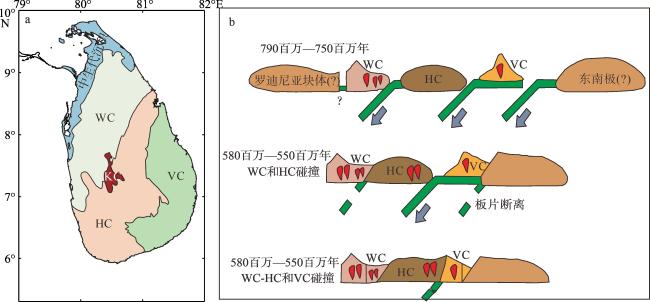
图2 斯里兰卡4个主要构造单元(a)和斯里兰卡多地体增生的构造演化模式图(b)[根据Kehelpannala (2004)修改]图a 基于审图号为GS(2016)1665号的标准世界地图制作, 底图无修改。图b中的绿色实线表示俯冲板片; 绿色虚线表示俯冲残留板片; 灰色箭头表示俯冲方向; 红色楔形表示岩浆活动。WC表示万宁杂岩, KC表示卡杜甘纳沃杂岩, HC表示高地杂岩, VC表示维贾延杂岩 Fig. 2 The four major tectonic units of Sri Lanka (a) and the tectonic evolution model of multi-complex accretion in Sri Lanka (b). [modified from Kehelpannala (2004)] |
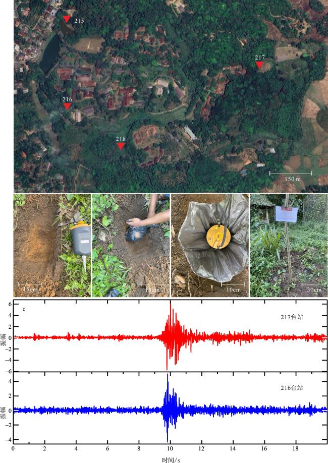
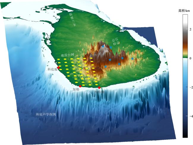
图3 综合地质灾害监测平台第一次布台试验及台站记录的背景噪声信号a. 卢胡纳大学农学院校区卫星图与4个台站(215—218)位置; b. 台站布设现场; c. 216、217台站记录的同一噪声源波形 Fig. 3 The first deployment experiment of the integrated geological hazards monitoring platform and the background noise signals recorded by the stations. (a) Satellite image of the Faculty of Agriculture campus, University of Ruhuna, with the locations of the four stations (215—218); (b) on-site station deployment; (c) waveforms of the same noise source recorded by stations 216 and 217 |
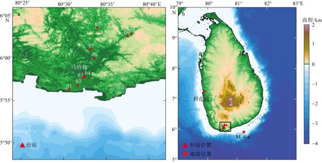
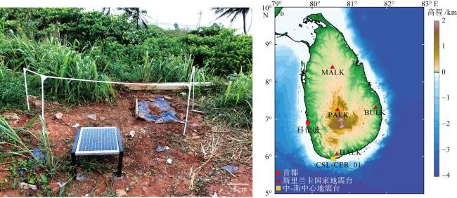
图4 沿海城市马特勒附近二维地震台站观测阵列(a)和地震位置与观测阵列位置(b)该图基于审图号为GS(2016)1665号的标准世界地图制作, 底图无修改。图b中的黑色方框表示图a范围 Fig. 4 The two-dimensional seismic observation array near the coastal city of Matara (a); locations of the earthquake and observation array (b) |
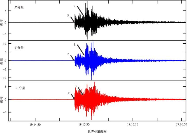
图5 04台站记录的地震(ML=4.4)三分量波形信号该地震发生在2023年4月24日19:15 (世界标准时间), 震中位于汉班托特南部海域。04台站位置及地震位置见图4。S表示地震横波到时; P表示地震纵波到时 Fig. 5 Three-component waveform signals of the earthquake (ML=4.4) recorded at station 04. The earthquake occurred on April 24, 2023, at 19:15 (UTC), with its epicenter located in the sea south of Hambantota. The locations of station 04 and the earthquake are shown in Fig. 4 |
| [1] |
刘宁, 莫利, 2015. “一带一路” 科技链: 斯里兰卡篇[J]. 科学新闻, 17(8): 94-96.
|
| [2] |
彭朝勇, 杨建思, 薛兵, 等, 2014. 一体化低功耗宽频带数字地震仪研制[J]. 地震学报, 36(1): 146-155, 159.
|
| [3] |
吴良士, 秦思婷, 2014. 斯里兰卡地质构造与区域成矿基本特征[J]. 矿床地质, 33(1): 233-236.
|
| [4] |
杨冬冬, 邱海军, 胡胜, 等, 2020. “一带一路”地区地质灾害时空分布特征及防治对策[J]. 科技导报, 38(16): 45-52.
|
| [5] |
赵磊, 张艳斌,
|
| [6] |
宗健业, 孙新蕾, 张鹏, 2020. 利用HVSR方法研究广州地区的场地效应及估算地震灾害特征[J]. 地震地质, 42(3): 628-639.
|
| [7] |
|
| [8] |
ATHAUDA A M M G I U B,
|
| [9] |
|
| [10] |
|
| [11] |
|
| [12] |
|
| [13] |
|
| [14] |
|
| [15] |
|
| [16] |
|
| [17] |
|
| [18] |
|
| [19] |
|
| [20] |
|
| [21] |
|
| [22] |
|
| [23] |
|
| [24] |
|
| [25] |
|
| [26] |
|
| [27] |
|
| [28] |
|
| [29] |
|
| [30] |
|
| [31] |
|
| [32] |
|
| [33] |
|
/
| 〈 |
|
〉 |
