
Journal of Tropical Oceanography >
An SST dependent geophysical model function for HY-2A scatterometer
Received date: 2021-03-30
Revised date: 2021-06-05
Online published: 2021-06-05
Supported by
National Natural Science Foundation of China(41876204)
National Natural Science Foundation of China(41476152)
Guangdong Province Science and Technology Innovation Strategy Special Fund(pdjh2020b0929)
Scientific Project of Guangdong Polytechnic of Industry and Commerce(2021-ZK-10)
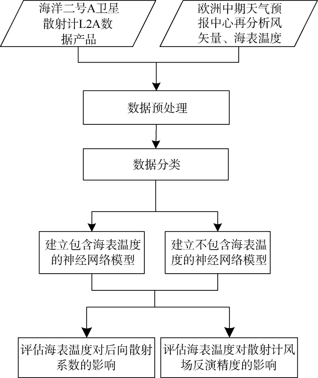
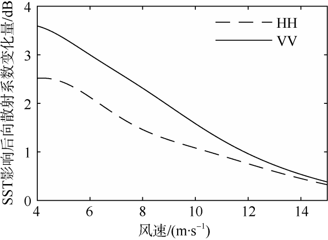
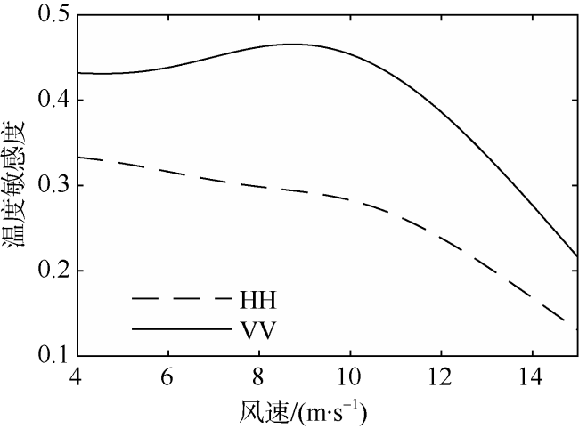
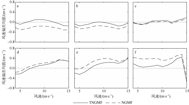
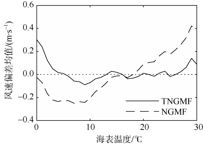
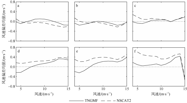
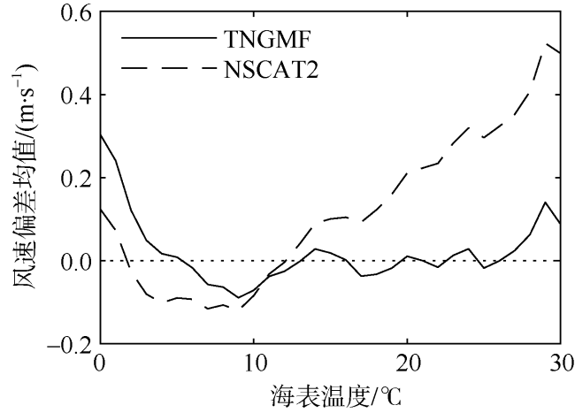
Scatterometers measure the normalized radar cross-section (NRCS) from the sea surface, which is then used to retrieve the wind vector over the sea surface using the geophysical model function (GMF). The GMFs adopted by the wind retrieval of scatterometers generally consider the influence of the radar polarization, radar incident angle, wind speed, and relative direction, but research showed that sea-surface temperature (SST) has a non negligible impact on the wind retrieval of scatterometers in the Ku band. In this study, we use Haiyang-2A scatterometer (HY2A-SCAT) L2A data, European Center for Medium-Range Weather Forecasts (ECMWF) reanalysis wind and SST data to build an SST-dependent GMF (TNGMF) using the artificial neural network. Using the TNGMF, we find that the NRCS increases with SST, and its range affected by SST is related to radar polarization and wind speed. In contrast, we use the same dataset and the same method to build another GMF without considering SST (NGMF); we then use NSCAT2 (NASA scatterometer-2) GMF, NGMF and TNGMF in the wind retrieval of HY2A-SCAT and find that NSCAT2 and NGMF wind speeds are systemically lower at low SST, and systemically higher at high SST. However, the TNGMF can well adjust the wind speed deviation affected by SST to improve the quality of retrieved wind.
CHEN Kehai , XIE Xuetong , ZHANG Jinlan , ZHENG Yan . An SST dependent geophysical model function for HY-2A scatterometer[J]. Journal of Tropical Oceanography, 2022 , 41(2) : 90 -102 . DOI: 10.11978/2021038
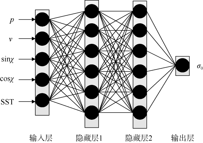
图3 包含海表温度的神经网络模型拓扑结构输入部分: p表示极化方式, v表示风速, sinχ和cosχ表示相对风向χ的正弦值和余弦值 SST表示海表温度; 输出σ0表示后向散射系数 Fig. 3 Topological architecture of neural network geophysical model with SST input. The input: p represents polarization, v represents wind speed, sinχ and cosχ respectively represent the sine and cosine of relative wind direction, and SST represents sea surface temperature. The output of σ0 represents the normalized radar cross-section (NRCS) from the sea surface |
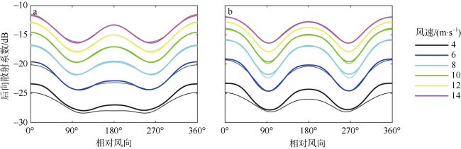
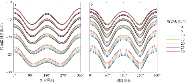
图5 HY-2A散射计包含海表温度的地球物理模型函数a. HH极化; b. VV极化。图中各曲线簇对应同一风速, 从下到上各曲线簇对应于4, 6, 8, 10, 12, 14 m·s-1 Fig. 5 SST-dependent GMF for HY-2A scatterometer. (a) HH polarization, and (b) VV polarization. Each cluster of curves in the figure is correspondent to a certain speed, from 4 to 14 m·s-1 by an interval of 2 m·s-1 |
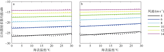
图6 后向散射系数均值随海表温度的变化曲线a. HH极化; b. VV极化。图中散点和实线分别为评估数据集计算和TNGMF计算得到的后向散射系数均值 Fig. 6 Mean of normalized radar cross-section varying with SST. (a) HH polarization, and (b) VV polarization. Dots and lines represent the mean of normalized radar cross-section from estimated data and TNGMF, respectively |
| [1] |
陈坤堂, 董晓龙, 徐星欧, 等, 2017. 微波散射计反演海面风场的神经网络方法研究[J]. 遥感技术与应用, 32(4): 683-690.
|
| [2] |
李燕初, 孙瀛, 林明森, 等, 1999. 用圆中数滤波器排除卫星散射计风场反演中的风向模糊[J]. 台湾海峡, 18(1): 42-48.
|
| [3] |
林明森, 宋新改, 彭海龙, 等, 2006. 散射计资料的风场神经网络反演算法研究[J]. 国土资源遥感, (2): 8-11.
|
| [4] |
王婷, 江文辉, 肖南峰, 2011. 基于改进BP神经网络的数字识别[J]. 电子设计工程, 19(3): 108-112.
|
| [5] |
解学通, 方裕, 陈晓翔, 等, 2005. 基于最大似然估计的海面风场反演算法研究[J]. 地理与地理信息科学, 21(1): 30-33.
|
| [6] |
解学通, 陈克海, 郭丽青, 等, 2007. 包含温度因子的海水地球物理模型函数建模研究[J]. 热带海洋学报, 26(6): 14-20.
|
| [7] |
|
| [8] |
|
| [9] |
|
| [10] |
|
| [11] |
|
| [12] |
|
| [13] |
|
| [14] |
|
| [15] |
|
| [16] |
|
| [17] |
|
| [18] |
|
| [19] |
|
| [20] |
|
| [21] |
|
| [22] |
|
| [23] |
|
| [24] |
|
| [25] |
|
| [26] |
|
| [27] |
|
/
| 〈 |
|
〉 |
