
Journal of Tropical Oceanography >
Green sea dykes: an overview of their principles of sediment, geomorphology and ecosystem dynamics
Copy editor: YAO Yantao
Received date: 2021-08-03
Revised date: 2021-09-11
Online published: 2021-10-11
Supported by
Key Project of National Natural Science Foundation of China(41530962)
Key Consultancy Study of the Shanghai Decision Making Advisory Committee(2020-5)
Green sea dyke represents a new concept of coastal defense, which combines traditional engineering structure with coastal ecosystem, to cope with the future trend of sea level rise and storm intensification. Before its application, however, the feasibility of such a system must be tested for low-lying coastal areas, where the risk of storm surge, storm-induced waves and shoreline erosion is greatest. The major issue is associated with the process of wave attenuation by the ecosystem and the way of using the ecosystem within the sea dyke system. For many years, wave energy dissipation has been an important research field for tidal flats, a typical environment of low-lying coasts, as well as beaches and rocky coast environments. Theoretical analysis, field observation and physical-mathematical modelling show that the coastal ecosystem indeed plays a significant role in wave energy dissipation: (1) resuspension and fluid mud movement dominate over bed friction in the mud area, in terms of wave height reduction; (2) wave attenuation occurs due to bed friction and bedload transport on the silt-sand flat at the lower part of the tidal flat, while on the upper mudflat it is caused mainly by re-suspension and suspended, fine-grained sediment transport; (3) in the vegetated ecosystems such as salt marsh, mangrove and seagrass beds, the efficiency of plants in reducing flow velocity and dissipating wave energy is higher than that of bare flats, due to plant morphological resistance and stem movement; and (4) wave attenuation is high when passing through biological reefs (e.g., coral and oyster reefs), especially during storms, with bed surface friction and wave breaking being the major mechanisms. Although the wave attenuation theory has been established, the optimization of the way the ecosystem is used within the sea dyke system requires further investigations, especially the techniques of ecological niche reconstruction on eroding coasts and the design of the sea dyke to improve structure safety. The relevant scientific problems include: adaptive biology for salt marsh plants and oysters in conjunction with hard engineering; stability of ecosystem in response to future environmental change; spatial configuration of ecosystem in the green sea dyke and the match between the ecosystem life cycle and the temporal scales of storm events; and the optimization of the sea dyke configuration, on the basis of the equilibrium coastal profile theory.
GAO Shu , JIA Jianjun , YU Qian . Green sea dykes: an overview of their principles of sediment, geomorphology and ecosystem dynamics[J]. Journal of Tropical Oceanography, 2022 , 41(4) : 1 -19 . DOI: 10.11978/YG2021002
图1 绿色海堤构成的示意图[改绘自高抒(2020)]硬质结构由挡水堤和抗浪堤组成, 盐沼、红树林、生物礁分布于海堤系统中, 用以耗散波能、保护海堤结构、促进生态修复 Fig. 1 Schematic diagram of the green sea dyke: the hard structure consists of the dykes against flooding and wave attack, respectively; salt marshes or mangroves and reefs are allocated within the system to dissipate wave energy and protect the hard structure (modified from Gao, 2020) |
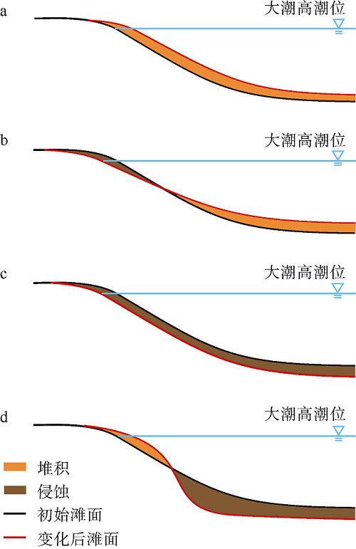
图2 岸线动态的4种可能情形a. 沉积物收支为正, 岸线向海推进; b. 沉积物收支为正, 岸线向陆退缩; c. 沉积物收支为负, 岸线向陆退缩; d. 沉积物收支为负, 岸线向海推进 Fig. 2 Four possible scenarios of shoreline dynamics: (a) positive sediment budget, with shoreline advancing to seaward; (b) positive sediment budget, with shoreline retreating to landward; (c) negative sediment budget, with shoreline retreatment; and (d) negative sediment budget, with shoreline advancement. The solid line represents the initial state, and the dotted line denotes the changing state |
图3 江苏潮滩牡蛎的生长环境照片(作者拍摄)a. 半固结状态泥底(江苏如东潮滩, 2007年4月25日); b. 地貌较稳定的潮水沟(江苏王港潮滩, 2003年7月4日); c. 互花米草植株主干(江苏王港潮滩, 2006年4月13日); d. 潮间带外缘(江苏海门潮滩, 2004年3月7日) Fig. 3 Photographs (taken by the authors) showing the growing environment of oyster over the Jiangsu tidal flats: (a) loosely consolidated mud bed (Rudong, 25th April, 2007); (b) tidal creeks with relatively stable morphology (Wanggang, 4th July, 2003); (c) lower parts of the Spartina alterniflora stems (Wanggang, 13th April, 2006); and (d) the outer edge of the intertidal zone (Haimen, 7th March, 2004) |
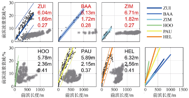
图4 荷兰海岸盐沼(光滩)消浪功能与盐沼(光滩)宽度的关系黑色点代表盐沼, 回归直线代表了盐沼的消浪比例和盐沼宽度的线性关系; 灰色星代表光滩; 各图中的数字自上而下为最高水位、最大波高和波高-水位比率; ZUI等英文缩写名称代表不同研究地点[据Willemsen等(2020)] Fig. 4 Linear relationship between wave energy dissipation and the width of salt marshes on the Dutch coast. Black dots denote salt marshes, and the regression lines denote the linear relationship between the wave energy dissipation ration and marsh width; gray stars denote bare flat; the three numbers in each panel denote, from top to bottom, the extreme water level, extreme wave height and the wave height/water level ratio; “ZUI” and the other abbreviations denote the name of different observation locations (after Willemsen et al, 2020) |
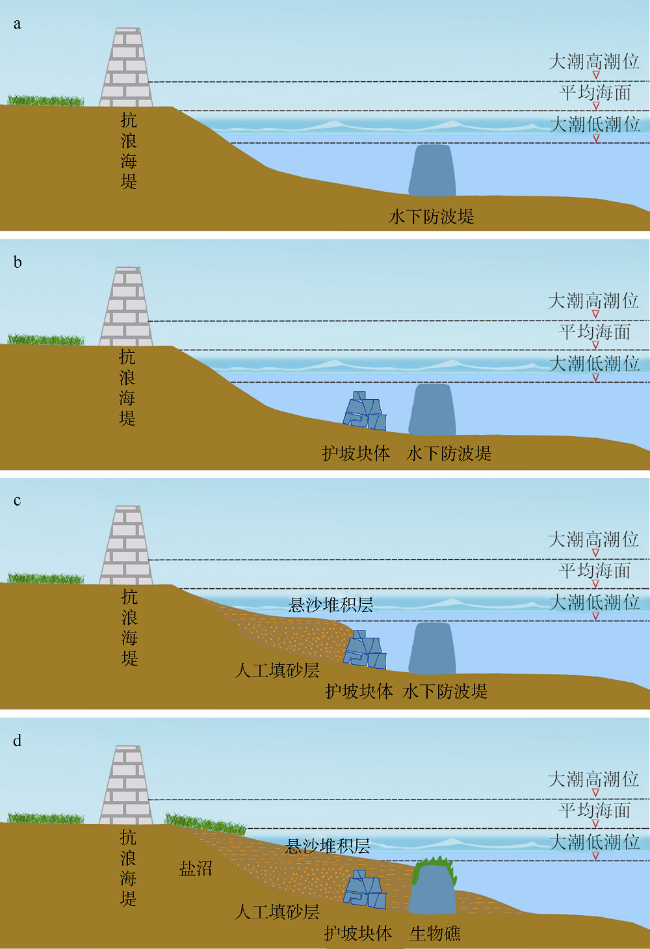
图5 侵蚀海岸修复潮滩生态的流程a. 海堤前设置透水式水下防波堤; b. 待修复潮滩前缘布设护坡块体; c. 人工填砂、悬沙天然堆积; d. 盐沼和牡蛎礁生态位形成 Fig. 5 A proposed procedure of restoring tidal flats on an eroding coast: (a) the installation of underwater breakwater; (b) slope protection measures in the front of the tidal flat to be restored; (c) artificial sand replenishment, together with tidally induced accumulation of suspended sediment; and (d) the formation of salt marsh and oyster reef niches |
| [1] |
陈才俊, 1991. 江苏沿海特大风暴潮灾研究[J]. 海洋通报, 10(6): 19-24.
|
| [2] |
陈吉余, 2010. 中国海岸侵蚀概要[M]. 北京: 海洋出版社.
|
| [3] |
陈蕴真, 高抒, 2010. 江苏南部海岸牡蛎礁演化的几何模型[J]. 海洋与湖沼, 41(1): 1-11.
|
| [4] |
高抒, 朱大奎, 1988. 江苏淤泥质海岸剖面的初步研究[J]. 南京大学学报, 24(1): 75-84.
|
| [5] |
高抒, 2020. 防范未来风暴潮灾害的绿色海堤蓝图[J]. 科学, 72(4): 12-16.
|
| [6] |
李润祥, 高抒, 王丹丹, 等, 2014. 2012年秋季白脊管藤壶在江苏如东互花米草盐沼的附着及分布[J]. 海洋学研究, 32(3): 26-35.
|
| [7] |
林鹏, 2001. 中国红树林研究进展[J]. 厦门大学学报(自然科学版), 40(2): 592-603.
|
| [8] |
刘桢峤, 周亮, 高抒, 2019. 基于地面3D激光扫描技术的海南岛南部海岸巨砾沉积研究[J]. 海洋学报, 41(11): 127-141.
|
| [9] |
全为民, 沈新强, 罗民波, 等, 2006. 河口地区牡蛎礁的生态功能及恢复措施[J]. 生态学杂志, 25(10): 1234-1239.
|
| [10] |
任美锷, 1986. 江苏省海岸带和海涂资源综合调查[M]. 北京: 海洋出版社: 517
|
| [11] |
任美锷, 2006. 黄河的输沙量: 过去、现在和将来——距今15万年以来的黄河泥沙收支表[J]. 地球科学进展, 21(6): 551-563.
|
| [12] |
王爱军, 高抒, 陈坚, 等, 2008. 福建泉州湾盐沼对台风“格美”的沉积动力响应[J]. 科学通报, 53(22): 2814-2823.
|
| [13] |
王宏, 陈永胜, 田立柱, 等, 2011. 渤海湾全新世贝壳堤与牡蛎礁: 古气候与海面变化[J]. 地质通报, 30(9): 1405-1411.
|
| [14] |
夏东兴, 王文海, 武桂秋, 等, 1993. 中国海岸侵蚀述要[J]. 地理学报, 48(5): 468-476.
|
| [15] |
张华, 韩广轩, 王德, 等, 2015. 基于生态工程的海岸带全球变化适应性防护策略[J]. 地球科学进展, 30(9): 996-1005.
|
| [16] |
张忍顺, 2004. 江苏小庙洪牡蛎礁的地貌-沉积特征[J]. 海洋与湖沼, 35(1): 1-7.
|
| [17] |
张忍顺, 沈永明, 陆丽云, 等, 2005. 江苏沿海互花米草(Spartina alterniflora)盐沼的形成过程[J]. 海洋与湖沼, 36(4): 358-366.
|
| [18] |
张玺, 楼子康, 1959. 牡蛎[M]. 北京: 科学出版社.
|
| [19] |
赵秧秧, 高抒, 2015. 台风风暴潮影响下潮滩沉积动力模拟初探——以江苏如东海岸为例[J]. 沉积学报, 33(1): 79-90.
|
| [20] |
朱爱意, 吴常文, 赵向炯, 2006. 舟山近海紫贻贝生物学性状初步研究[J]. 浙江海洋学院学报(自然科学版), 25(1): 1-4.
|
| [21] |
|
| [22] |
|
| [23] |
|
| [24] |
|
| [25] |
|
| [26] |
|
| [27] |
|
| [28] |
|
| [29] |
|
| [30] |
|
| [31] |
|
| [32] |
|
| [33] |
|
| [34] |
|
| [35] |
|
| [36] |
|
| [37] |
|
| [38] |
|
| [39] |
|
| [40] |
|
| [41] |
|
| [42] |
|
| [43] |
|
| [44] |
|
| [45] |
|
| [46] |
|
| [47] |
|
| [48] |
|
| [49] |
|
| [50] |
|
| [51] |
|
| [52] |
|
| [53] |
|
| [54] |
|
| [55] |
|
| [56] |
|
| [57] |
|
| [58] |
|
| [59] |
|
| [60] |
|
| [61] |
|
| [62] |
|
| [63] |
|
| [64] |
|
| [65] |
|
| [66] |
|
| [67] |
|
| [68] |
|
| [69] |
|
| [70] |
|
| [71] |
|
| [72] |
|
| [73] |
|
| [74] |
|
| [75] |
|
| [76] |
|
| [77] |
|
| [78] |
|
| [79] |
|
| [80] |
|
| [81] |
|
| [82] |
|
| [83] |
|
| [84] |
|
| [85] |
|
| [86] |
|
| [87] |
|
| [88] |
|
| [89] |
|
| [90] |
|
| [91] |
|
| [92] |
|
| [93] |
|
| [94] |
|
| [95] |
|
| [96] |
|
| [97] |
|
| [98] |
|
| [99] |
|
| [100] |
|
| [101] |
|
| [102] |
|
| [103] |
|
| [104] |
|
| [105] |
|
| [106] |
|
| [107] |
|
| [108] |
|
| [109] |
|
| [110] |
|
| [111] |
|
| [112] |
|
| [113] |
|
| [114] |
|
| [115] |
|
| [116] |
|
| [117] |
|
| [118] |
|
| [119] |
|
| [120] |
|
| [121] |
|
| [122] |
|
| [123] |
|
| [124] |
|
| [125] |
|
| [126] |
|
| [127] |
|
| [128] |
|
| [129] |
|
| [130] |
|
| [131] |
|
| [132] |
|
| [133] |
|
| [134] |
|
| [135] |
|
/
| 〈 |
|
〉 |


