
Journal of Tropical Oceanography >
Study on the tidal dynamics in Daya Bay, China — Part Ⅱ. The generation of double high waters and double-peak flood-current flows
Received date: 2016-08-23
Request revised date: 2016-09-22
Online published: 2017-06-01
Supported by
Major State Basic Research Development Program (2015CB452905)
China Postdoctoral Science Foundation (2015T80742)
Copyright
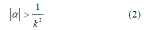
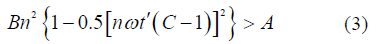
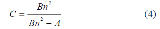
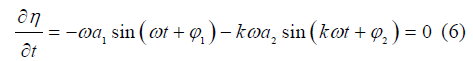
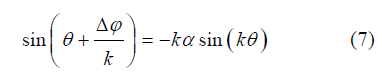
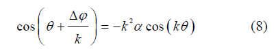
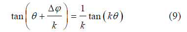
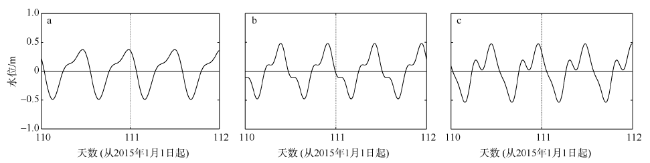
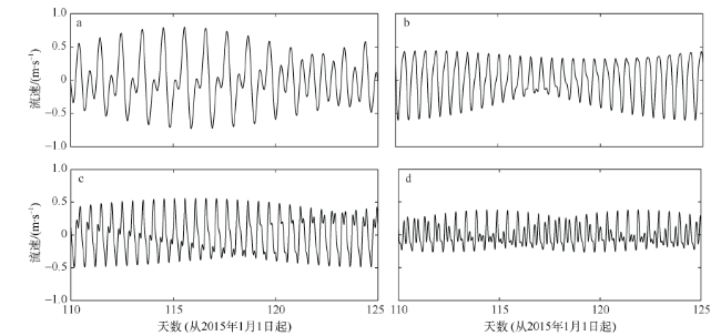
This paper is the second part of our studies on tidal dynamics in Daya Bay (DYB), China. It illustrates the generation mechanism of double high waters and double-peak flood-current flows. Double high waters resulted from a subtle interaction between a semi-diurnal tide (M2) and higher harmonics (M4 and M6) in DYB. Based on previous studies, the conditions to produce double high waters and double-peak flood-current flows were found in this study by using an analytical method. The double high waters could be generated by combinations of M2/M6 tides (limited in the Fanhe Harbor) or M2/M4/M6 tides; however, the combination of M2/M4 tides failed to produce this unique phenomenon in DYB. Besides, the water falling range between two high waters generated by the combination of M2/M4/M6 tides was larger than that of M2/M6 tides, both in extension and in magnitude. The combinations of M2/M4, M2/M6 and M2/M4/M6 were all able to produce double-peak flood-current flows, but the magnitude of M2/M4/M6 triplet was larger than the other two pairs in DYB.
YAN Yuhan , WU Wen , SONG Dehai , BAO Xianwen . Study on the tidal dynamics in Daya Bay, China — Part Ⅱ. The generation of double high waters and double-peak flood-current flows[J]. Journal of Tropical Oceanography, 2017 , 36(3) : 46 -54 . DOI: 10.11978/2016079
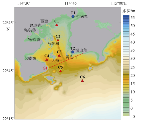
Fig. 1 Bathymetry map of Daya Bay, with T1-T2 indicating tidal elevation stations and C1-C6 indicating tidal current stations图1 大亚湾地形图^图中T1和T2为水位站, C1~C6为海流站 |
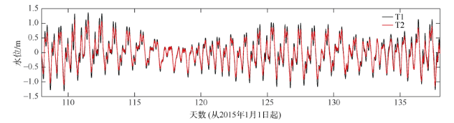
Fig. 2 Observed water levels at Station T1 (black) and Station T2 (red)图2 T1(黑色)和T2(红色)站实测水位时间序列^ |
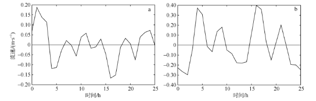
Fig. 3 Observed current velocity at Station C3 for (a) u with eastward positive and (b) v with northward positive图3 C3站的实测流速时间序列^a. 东西向流速(东为正); b. 为南北向流速(北为正) |
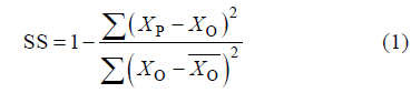
Fig. 4 The reproduced tidal-elevation curves at Station T1 by using combination of M2 tide and its overtides for (a) M2/M4, (b) M2/M6 and (c) M2/M4/M6图4 T1站M2分潮与其倍潮的水位重构图^a. M2/M4; b. M2/M6; c. M2/M4/M6 |
Fig. 5 The reproduced tidal-elevation curves at station T1 by using combination of individual constituents for (a) O1/K1/M2, (b) M2/S2/MS4, (c) M2/MS4/2MS6 , and (d) S2/M4/2MS6图5 T1站不同分潮组合的水位重构图^a. O1/K1/M2; b. M2/S2/MS4; c. M2/MS4/2MS6; d. S2/M4/2MS6 |

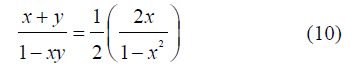
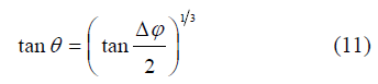
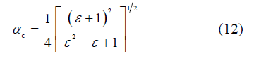
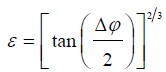 ; αc为临界状态下M2分潮与其谐波倍潮的振幅的比值。

Fig. 6 Two condition to produce double high waters (a) Conditions to produce double high waters by the combination of M2 and M4 tides. Color indicates water falling range (shown in meters), assuming |
Fig. 7 The distribution of water falling range (units: m) in Daya Bay by using combination of individual constituents for (a) M2/M6 and (b) M2/M4/M6图 7 大亚湾内M2/M6(a)和M2/M4/M6(b)所产生水位落差的分布图 |
Fig. 8 (a) Difference between |
Fig. 9 The distribution of Current Difference Range (units: m·s-1) in Daya Bay by using combination of individual constituents for (a) M2/M4, (b) M2/M6 and (c) M2/M4/M6图 9 大亚湾M2/M4 (a)、M2/M6 (b)和M2/M4/M6 (c)所产生的流速落差分布图 |
The authors have declared that no competing interests exist.
| [1] |
|
| [2] |
|
| [3] |
|
| [4] |
|
| [5] |
|
| [6] |
|
| [7] |
|
| [8] |
|
| [9] |
|
/
| 〈 |
|
〉 |

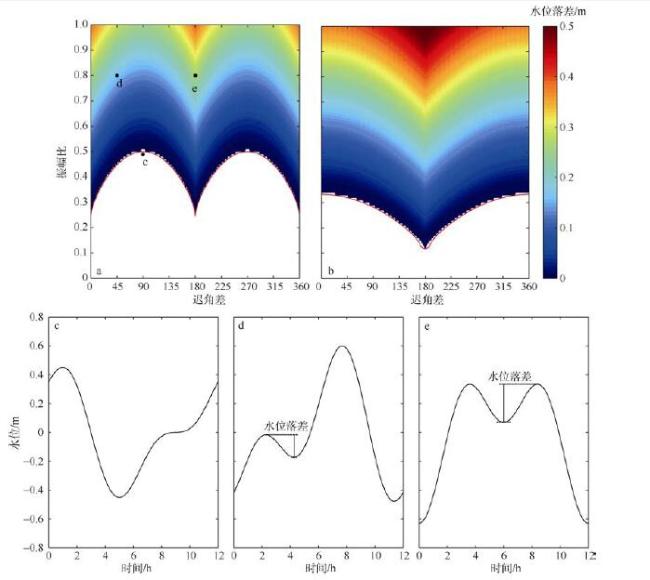
 = 0.35 m and
  = 0°. The red solid line gives the analytical critical solution. (b) is the same as (a), except for M2 and M6. (c) The tidal-elevation curve for
  /
/ = 0.49 and
  -
- = 90°. (d) The tidal-elevation curve for
  /
/ = 0.80 and
  -
- = 45°. (e) The tidal-elevation curve for
  /
/ = 0.80 and
  -
- = 180°. The relationships between amplitude ratio and phase lag shown in (c), (d) and (e) corresponding to the black dots c, d and e in (a)
 = 0.35m、
 = 0°, 红线代表的是临界条件的解析解; 图中黑点c、d、e分别对应图c、d、e中的振幅比和迟角差关系。b. 由M2/M6分潮造成的双峰水位的形成条件。c. 当
 /
/ = 0.49、
 -
- = 90°时的水位序列图; d. 当
 /
/ = 0.80、
 -
- = 45°时的水位序列图; e. 当
 /
/ = 0.80、
 -
- = 180°时的水位序列图
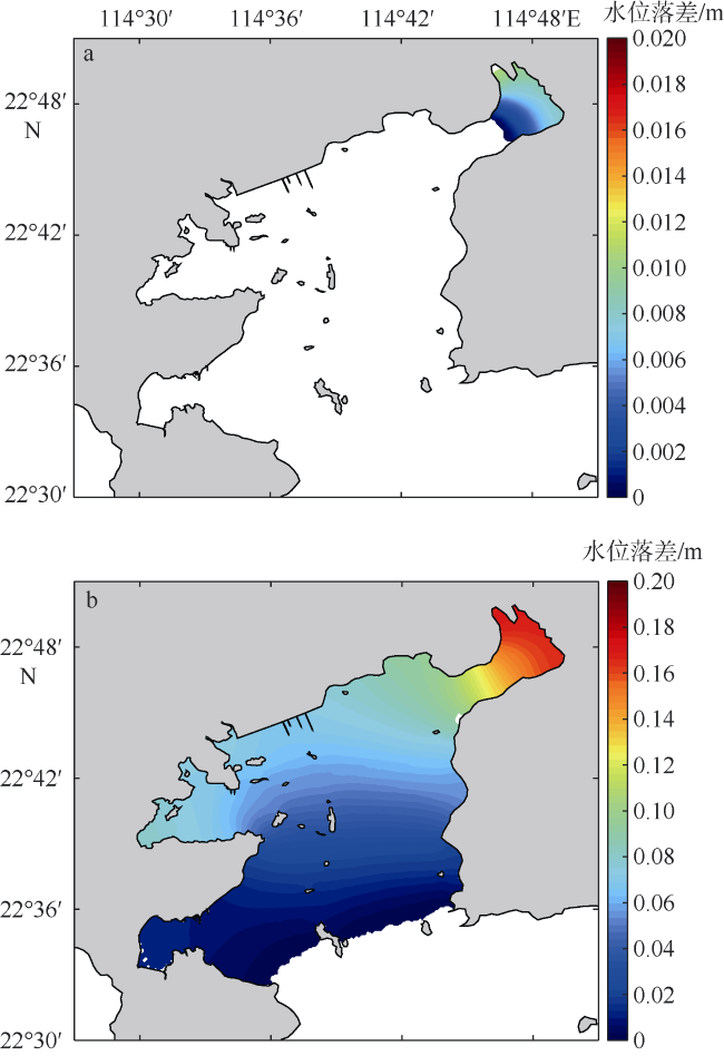
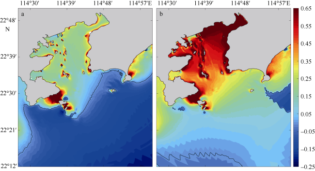
 /
/ and critical
  /
/ to produce double-peak flood-current flow (positive indicates the capability to produce double-peak flood- current flow). (b) Same as (a), except for M2 and M6
 /
/ 和临界
和临界 /
/ 的差(a)和利用模式结果计算
 /
/ 和临界
和临界 /
/ 的差(b)^数值为正代表可以产生涨潮流速双峰; 图中黑色实线是数值为0的等值线
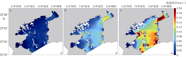