
Journal of Tropical Oceanography >
Relationship of tidal level and different tidal species in complex river networks
Received date: 2018-04-18
Request revised date: 2018-06-29
Online published: 2019-01-16
Supported by
National Key Research Program of China (2017YFC0405900)
National Natural Science Foundation of China (41676078)
Copyright
The surface level variation greatly depends on semidiurnal and diurnal tidal species in the estuaries of irregularly semidiurnal tides. However, fortnightly tidal species have a great impact on the mean water surface topography upriver due to substantial difference in damping of the main different tidal species. Therefore, the effect of different tidal species on tidal level distribution has obviously regional characteristics when tides propagate into deltaic river networks. In this paper, a one-dimensional flow model of the Pearl River networks was used to obtain a series of high-frequency and long-period tidal levels. Then, spatial distributions of the four main tidal species in the study area were obtained for further study by continuous wavelet transformation (CWT) and reconstruction. Finally, a new pixel affinity for spectral image segmentation was employed to compare the similarity between two figures, which implied a spatial correlation of tidal species and tidal level distribution in the complex river network. The results showed that surface level variation is influenced by semi-diurnal and diurnal tidal species near the outlets, while mean water surface topography is influenced by fortnightly tidal species in the complex river network.
QIN Lizhen , ZHANG Wei , GUAN Mingkai , ZHAO Sheng , CHENG Liangqiu . Relationship of tidal level and different tidal species in complex river networks[J]. Journal of Tropical Oceanography, 2019 , 38(1) : 27 -34 . DOI: 10.11978/2018044
Tab. 1 Four main tidal species and principal tidal constituents表1 潮汐分潮簇及主要分潮 |
| 分潮簇 | 分潮种类 | 周期 | 频率/cph |
|---|---|---|---|
| 全日分潮簇(D1) | Q1 | 26.87太阳时 | 0.0372 |
| O1 | 25.82太阳时 | 0.0387 | |
| P1 | 24.07太阳时 | 0.0415 | |
| K1 | 23.93太阳时 | 0.0418 | |
| 半日分潮簇(D2) | N2 | 12.66太阳时 | 0.0790 |
| M2 | 12.42太阳时 | 0.0805 | |
| S2 | 12.00太阳时 | 0.0833 | |
| K2 | 11.97太阳时 | 0.0835 | |
| 四分之一日 分潮簇(D4) | MN4 | 6.27太阳时 | 0.1595 |
| M4 | 6.21太阳时 | 0.1610 | |
| MS4 | 6.10太阳时 | 0.1639 | |
| 半月分潮簇(D1/14) | MSf | 14.77太阳日 | 0.0028 |
注:“cph”即cycle per hour (次/小时), 常用于表示天文潮汐学中的频率。 |
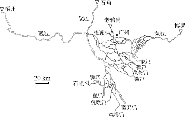
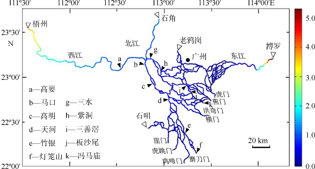
Fig. 1 Model domain图1 模型范围示意图 |
Tab.2 Frequency range of main tidal species used in CWT表2 CWT方法中分潮簇的频率范围 |
| 分潮簇 | 频率范围 |
|---|---|
| D4 | 2-3~2-1.5 |
| D2 | 2-1.5~2-0.5 |
| D1 | 2-0.5~20.5 |
| D1/14 | 23.4~24.5 |
Fig. 2 Spatial distribution of the mean tidal level. Units: m图2 平均潮位(单位: m)空间分布图 |
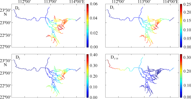
Fig. 3 Spatial distributions of contributions of four main tidal species (D4, D2, D1, and D1/14, respectively). Units: m图3 D4、D2、D1和D1/14振幅(单位: m)空间分布图 |
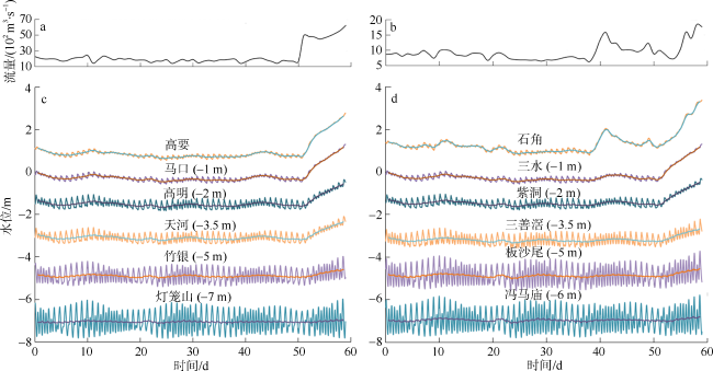
Fig. 4 River discharges and tidal levels along the main streams of the West River and the North River in dry seasons of 2005, respectively. a) River discharge at Gaoyao; b) river discharge at Shijiao; c) tidal levels at six hydrologic stations of the West River; and d) tidal levels at six hydrologic stations of the North River图4 2015年枯季西江干流、北江干流流量及12个测站的潮位时间序列 |
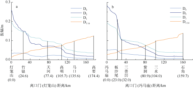
Fig. 5 Amplitudes of four main tidal species along the main streams of the West River and the North River, respectively. a) The main streams of the West River, and b) the main streams of the North River图5 西江干流、北江干流主要分潮簇振幅的沿程变化 |
The authors have declared that no competing interests exist.
| [1] |
|
| [2] |
|
| [3] |
|
| [4] |
珠江水利科学研究院, 水利部珠江河口海岸工程技术研究中心,2013. 珠江河口治理开发研究[M]. 北京: 中国水利水电出版社 (in Chinese).
|
| [5] |
|
| [6] |
|
| [7] |
|
| [8] |
|
| [9] |
|
| [10] |
|
| [11] |
|
| [12] |
|
| [13] |
|
| [14] |
|
| [15] |
|
| [16] |
|
| [17] |
|
/
| 〈 |
|
〉 |
