Marine Geology

Research progress on the Zhongnan-Liyue Fault Zone in the South China Sea Basin*

  • XU Ziying ,
  • WANG Jun ,
  • GAO Hongfang ,
  • SUN Guihua ,
  • SUN Meijing ,
  • NIE Xin ,
  • ZHU Rongwei
Expand
  • Key Laboratory of Marine Mineral Resources, Ministry of Natural Resources, Guangzhou Marine Geological Survey, Guangzhou 510075, China
Corresponding author: XU Ziying. E-mail:

Received date: 2018-04-27

  Request revised date: 2018-11-27

  Online published: 2019-04-15

Supported by

National Natural Science Foundation of China (41606080, 41576068)

Natural Science Foundation of Guangdong Province, China (2017A030312002)

China Geological Survey Program (GZH201400202, 1212011220117, DD20160138, GZH201400203, 121201002000150002, DD20160140, and DD20189642)

Key Laboratory of Marine Mineral Resources, Ministry of Land and Resources (KLMMR-2013-A-10)

Copyright

热带海洋学报编辑部

Abstract

In this paper, we review latest research on the Zhongnan-Liyue Fault Zone (ZLFZ), and then analyze the spatial distribution and tectonic deformation feature of the ZLFZ based on the geophysical data including topographic, seismic, gravity, and magnetic data. The results show that the ZLFZ in the South China Sea Basin has obvious north-south segmentation characteristics. The north section, which is between northwest sub-basin and east sub-basin, is a NNW trend narrow zone with a width of ~16 km from (18°00'N, 115°30'E) to (17°30'N, 116°30'E). The south section, which is between southwest sub-basin and east sub-basin, is a NNW trend wide zone with a width of 60~80 km from the east of the Zhongsha Bank to the west of the Liyue Bank. The main fault of the ZLFZ is NNW trend along the seamounts’ ridge of Zhongnan. The ZLFZ of transition region is NNE trend from the north section to the south section. On the eastern and western sides of the ZLFZ, the sub-basin’s sedimentary thickness and oceanic crust thickness are obviously different. We speculate that the ZLFZ plays an important role in the geological structure of sub-basin. According to the change of crustal structure, we suspect that the ZLFZ is at least a crustal fracture zone.

Cite this article

XU Ziying , WANG Jun , GAO Hongfang , SUN Guihua , SUN Meijing , NIE Xin , ZHU Rongwei . Research progress on the Zhongnan-Liyue Fault Zone in the South China Sea Basin*[J]. Journal of Tropical Oceanography, 2019 , 38(2) : 86 -94 . DOI: 10.11978/2018048

南海经历了新生代大陆边缘裂谷和随后的海底扩张, 其海盆总体呈菱形, 向西南收敛, 海盆洋壳东宽西窄。据地质与地球物理等方面特征, 南海海盆可划分为西北次海盆、东部次海盆和西南次海盆(图1)。
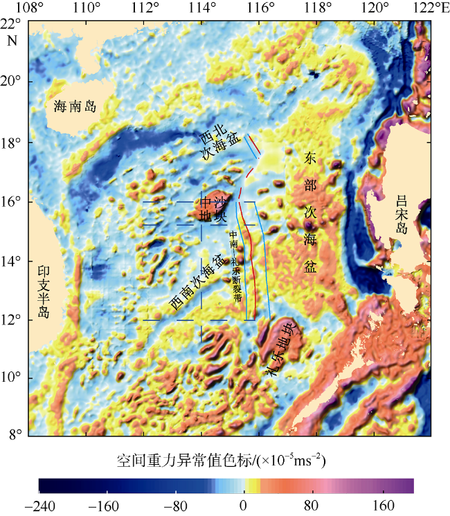
Fig. 1 The bathymetric map of the South China Sea and the location of the Zhongnan-Liyue Fault Zone

图1 南海地形图(杨胜雄 等, 2015)及中南—礼乐断裂在南海海盆中的位置分布图
黄色实线是姚伯初(1995)的研究结果; 红色虚线是Ruan等(2016)的研究结果; 橙色虚线是Sibuet等(2016)的研究结果; 紫色实线是Frank (Frank, 2013; Frank et al, 2014)和Barckhausen等(2014)的研究结果。白色和红色实线为本文研究结果: 白色实线为断裂带的宽度范围; 红色实线为断裂带的主控断裂位置; 红色圆点为IODP349航次U1431钻井站位; L1、L2、L3为地震剖面编号

中南—礼乐断裂带位于南海海盆中, 前人虽然通过重力、磁力、地震等资料对该断裂带的存在、走向和性质等进行过研究(Briais et al, 1993; 姚伯初, 1995; 阎贫 等, 2008; Li et al, 2014; Barckhausen et al, 2014; Frank et al, 2014; Ruan et al, 2016; Sibuet et al, 2016), 但研究比较零星和局限, 该断裂带的具体位置、走向、延伸长度、宽度等都不清晰, 断裂性质(转换断裂或走滑断裂?)也存在分歧。也鲜少有人对该断裂带的内部变形特征进行详细刻画, 对其形成机制研究更少。
本文首先综述了中南—礼乐断裂带的国内外研究现状, 然后基于重力、磁力、地震剖面和地形等地球物理资料, 系统分析中南—礼乐断裂带在海盆中的空间展布特征, 刻画该断裂带内部构造形变特征, 探讨其深部结构特征及其对东西两侧次级海盆的地质构造的影响。

1 国内外研究现状

前人通过构造-地层、重磁异常特征、地震剖面、海底地形及海底地震仪(OBS)探测等手段与方法对中南—礼乐断裂带的空间分布及断裂带性质进行了研究与探讨。针对中南—礼乐断裂带的空间位置分布的研究, 主要存在两种观点: 一种是该断裂带呈NS向发育(姚伯初 等, 1994; 姚伯初, 1995; Schlüter et al, 1996; Li et al, 2008, 2014; 黎雨晗 等, 2017)。其中姚伯初(1995)认为中南—礼乐断裂带北起珠江海谷, 中经西南次海盆与东部次海盆过渡区, 南至加里曼丹的沙巴地区, 是一条规模巨大的断裂(图1)。另一种观点是该断裂带呈NNW向展布(Barckhausen et al, 2004, 2014; 阎贫 等, 2008; Frank, 2013; Frank et al, 2014; Ruan et al, 2016; Sibuet et al, 2016)。同时许多学者对中南—礼乐断裂带的断裂性质进行了探讨, 主要存在三种观点, 部分学者认为中南—礼乐断裂带为走滑断裂(姚伯初, 1995; 阎贫 等, 2008)。还有少部分学者认为中南—礼乐断裂带不是转换断层就是平移断层(Briais et al, 1993; 李家彪 等, 2011)。大部分学者认为中南—礼乐断裂带为转换断裂, 如Taylor等(1980, 1983)通过对磁条带的识别, 认为东部次海盆在早渐新世至早中新世扩张, 西南次海盆可能为早中新世扩张, 并推测两海盆之间存在一条转换断裂。Tongkul (1993, 1994)通过构造-地层分析来研究加里曼丹沙巴地区的地质构造时, 将中南—礼乐断裂带延至沙巴地区, 作为东北沙巴的东西向与西南沙巴的北东向的分界线, 并认为是一条转换断裂。Barckhausen等(2004, 2014)根据磁异常分析, 认为在西南次海盆和东部次海盆之间存在一条转换断裂从中沙地块东侧(115°E)向东南延伸到礼乐滩西部(117°E)(图1)。Sibuet等(2016)通过重磁分析认为在南海扩张过程中, 在西南次海盆与东部次海盆之间存在一条重要转换断裂带——中南断裂带, 从中沙地块的东侧延伸到礼乐滩的东侧(图1)。Li等(2008, 2012, 2014)通过海盆磁异常走向分析, 认为在西北次海盆与东部次海盆北部之间存在一条协调转换断裂, 该转换断裂可以与南部东部次海盆与西南次海盆之间的转换断裂相连, 构成一个区域转换断裂。Ruan等(2016)通过OBS测线研究认为在东部次海盆和西南次海盆之间存在40~80km宽的弧形破碎带, 并认为该破碎带是东部次海盆NS向扩张转为西南次海盆NW-SE向扩张的转换断层, 是中沙块体与礼乐滩破裂分离过程中形成的(图1)。

2 中南—礼乐断裂带的地球物理特征

近年来, 笔者根据近年新采集的高精度地震剖面, 重力、磁力及地形等资料研究中南—礼乐断裂带时, 发现中南—礼乐断裂带由北至南在宽度、走向和内部形变等构造特征都存在明显变化, 具有明显的分段性。

2.1 中南—礼乐断裂带北段地球物理特征

北段分布在西北次海盆及东部次海盆北部之间(16°N以北), 地震剖面上(图2b), 中南—礼乐断裂带位于凹陷区, 宽约15km, 主控断裂控制了早期沉积物发育, 断裂断穿基底深达0.5s (双程走时, 下同), 根据地震剖面反射特征和Ding等(2018)对上下地壳反射界面的分析, 认为该主控断裂断穿了上地壳反射界面。在该断裂带基底以下存在厚约0.25~0.5s的破碎混杂体, 根据IODP349航次U1431井钻遇的基底是玄武岩中夹有沉积泥岩(Li et al, 2015), 推测该区域基底及其以下的混杂体为玄武岩与沉积层的混杂体。内部构造变形上, 断裂带内基底起伏相对平缓, 小断裂发育少, 主控断裂倾角相对平缓。moho面反射在断裂两侧表现不同, 但总体较清晰, 东部次海盆moho面反射出现在8.6~8.7s, 西北次海盆moho面反射出现在8.3~8.6s区间。进入中南—礼乐断裂带, moho面反射向下倾斜至9s左右。断裂带两侧海盆的沉积物厚度发育也不同, 西北次海盆沉积物总厚度薄, 约1s; 东部次海盆沉积物厚度总体较厚, 约1.6s; 而进入中南—礼乐断裂带, 沉积物明显变厚, 约2s。磁力异常平面图上(图3), 中南—礼乐断裂带两侧的磁异常强度及走向明显不同, 东部次海盆北部磁异常强度表现为高值正负异常相间, 磁异常条带狭长, 呈明显的近EW走向。西北次海盆磁强度为低值正负异常, 磁异常条带宽缓短小, 该断裂带由(18°00'N, 115°30'E)向(17°30'N, 116°00'E)呈NNW向分布。自由空间重力异常图上(图4), 该断裂带两侧表现为东部次海盆重力为正值异常, 西北次海盆重力为负值异常, 断裂带由(18°00'N, 115°30'E)向(17°30'N, 116°00'E)呈NNW向分布。海底地形上该断裂带反映不明显。根据上述地震剖面、重力、磁力和地形等地球物理资料综合分析, 认为北段(西北次海盆与东部次海盆北部之间)存在宽约15km的狭条带, 即中南—礼乐断裂带, 由(18°00'N, 115°30'E)向(17°30'N, 116°00'E)呈NNW向分布。
Fig. 2 Seismic profile characteristics of the Zhongnan-Liyue Fault Zone along the survey line L1

图2 中南—礼乐断裂带在测线L1地震剖面反射特征
红色粗线为中南—礼乐断裂带主控断裂; 黑色实线表示基底; 黑色虚线表示moho面; UCR: 上地壳反射界面。图b中虚线方框表示图c位置

Fig. 3 Location of the Zhongnan-Liyue Fault Zone according to magnetic anomalies

图3 中南—礼乐断裂带在南海海盆磁异常图上的分布位置
黑色实线为断裂带的宽度范围; 红色实线为断裂带的主控断裂位置; 红色虚线为推测断裂带的位置。南海磁异常图引自杨胜雄等(2015)

Fig. 4 Location of the Zhongnan-Liyue Fault Zone according to the free-air gravity anomalies

图4 中南—礼乐断裂带在南海海盆空间重力异常图上的分布位置
蓝色实线为断裂带的宽度范围; 红色实线为断裂带的主控断裂位置; 红色虚线为推测断裂带的位置。南海空间重力异常图引自杨胜雄等(2015)

2.2 中南—礼乐断裂带南段地球物理特征

南段分布在西南次海盆及东部次海盆之间(12°N—16°N)。地震剖面上(图5图6), 中南—礼乐断裂带的主控断裂发育深且陡, 控制了早期沉积的发育, 海山沿主控断裂发育, 在断裂带的凹部存在窄且深的垂直沉积楔, 推测为早期玄武岩基底断块间的沉积充填。靠近东部次海盆侧发育密集的次级正断层, 倾角近于垂直, 断穿基底, 为早期发育的正断层, 基底之下存在厚约0.5s的明显破碎的混杂体, 地震特性上表现为强振幅, 连续性差, 呈杂乱反射结构。根据U1431井钻遇的基底岩性认识, 推测该区域基底及其以下的破碎体也是玄武岩与沉积层的混杂体。Jones (2009)认为在大型断裂带内有异常低的地壳速度值, 这恰好与Ruan等(2016)认为中南断裂破碎区域存在40~80km上地壳低速异常体(图1)相互佐证, 故认为该断裂破碎区为中南—礼乐 断裂带。内部构造变形上, 该段地质现象丰富, 主控断裂发育深且陡, 控制了早期沉积, 沉积物呈楔状发育, 早期陡直的正断裂非常发育, 断穿基底, 基底起伏较大。地震剖面上该断裂带宽约60km, 平面上由中沙海台东侧(16°00'N, 115°30')向礼乐地块西侧(12°00'N, 116°30'E)呈NNW向展布。
Fig. 5 Seismic profile characteristics of the Zhongnan-Liyue Fault Zone along the survey line L2

图5 中南—礼乐断裂带在测线L2上的地震剖面反射特征
红色粗线为中南—礼乐断裂带主控断裂; 黑色实线表示基底; 黑色虚线表示moho面; 图b中虚线方框表示图c位置

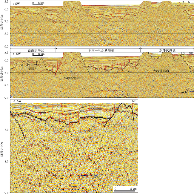
Fig. 6 Seismic profile characteristics of the Zhongnan-Liyue Fault Zone along the survey line L3

图6 中南—礼乐断裂带在测线L3上的地震剖面反射特征
红色粗线为中南—礼乐断裂带主控断裂; 黑色实线表示基底; 黑色虚线表示moho面; 图b中虚线方框表示图c位置

断裂带两侧的海盆在沉积物总厚度、海底水深及moho面深度都存在差异。沉积物总厚度上, 西南次海盆沉积物总厚度薄, 约0.4~0.6s, 东部次海盆沉积物总厚度相对较厚, 约1.0~1.1s, 断裂带内沉积厚度最大, 达1.0~1.8s。海底水深上, 靠近海盆南侧, 西南次海盆海底水深最深, 其次是中南—礼乐断裂带, 东部次海盆的海底水深相对浅(图6)。moho面在南段特征表现为断续出现, 断裂带下的moho面也不清晰, 推测与大规模岩浆活动发育有关, moho面深度上, 中沙地块东南侧地震剖面显示(图5b、5c), 东部次海盆Moho面反射出现在8.2s左右, 西南次海盆moho面反射出现在7.6s左右, 进入中南—礼乐断裂带, moho面反射向下掉至9.3s左右。礼乐地块西北侧地震剖面显示(图6b、6c), 东部次海盆moho面反射出现在8.4s左右, 西南次海盆moho面反射出现在7.6s左右, 中南—礼乐断裂带内moho面反射为8.5s左右。
磁异常平面图上(图3), 两侧海盆的磁异常值和走向明显不一, 西南次海盆磁异常为正负交替变化, 表现为密集的高值正异常为主, 磁异常主体走向呈NE向。东部次海盆磁异常表现为密集的高值正负异常相间, 磁异常主体呈近EW向。在两次海盆之间存在宽约80km的磁异常过渡区。该过渡区磁异常弱且磁条带不连续, 表现为宽缓的低值正负异常, 推测为中南—礼乐断裂带破碎区。自由空间重力异常图上(图4), 东部次海盆自由空间重力异常为明显的高值正异常区, 西南次海盆的自由空间重力异常总体表现为低值正负异常区。进入中南—礼乐断裂带, 为重力异常过渡区, 重力异常总体表现为低值, 中南海岭为相对高值区, 重力异常等值线呈明显的NNW向展布。地形上, 中南海岭延伸方向对应着中南—礼乐断裂带的主控断裂平面展布方向, 呈NNW向展布, 该断裂带切割了东部次海盆和西部次海盆走向不同的扩张脊。根据上述地震剖面、重力、磁力和地形等地球物理资料综合分析, 认为在南段(西南次海盆与东部次海盆之间)存在宽约60~ 80km的断裂破碎带, 即中南—礼乐断裂带, 由中沙海台东侧(16°00'N, 115°30')向礼乐地块西侧(12°00'N, 116°30'E)呈NNW向展布。

3 讨论

3.1 中南—礼乐断裂带对两侧海盆沉积的影响

中南—礼乐断裂带两侧的各次海盆的沉积厚度存在明显差异, 北段地震剖面显示, 中南—礼乐断裂带内沉积物厚度最厚, 西侧的西北次海盆沉积物总厚度小于东侧的东部次海盆沉积物总厚度(图2)。进入南段, 西南次海盆沉积物总厚度明显小于东部次海盆沉积物总厚度, 断裂带内沉积物最厚(图5图6)。由此可见, 断裂带内的沉积物厚度比两侧次海盆的沉积物厚, 根据该断裂带两侧次海盆沉积厚度的明显差异, 推测该断裂带对其东西两侧次海盆的沉积厚度具有控制作用。

3.2 中南—礼乐断裂带深部结构特征

深部结构上, 中南—礼乐断裂带两侧次海盆的洋壳结构明显不同。北段地震剖面显示(图2b、2c), 东部次海盆洋壳厚约1.7~1.8s, 西北次海盆洋壳厚约1.9~2.2s, 进入中南—礼乐断裂带, 洋壳厚约1.75s左右, 西北次海盆洋壳厚度大于东部次海盆。中南—礼乐主控断裂断穿基底深达0.5s, 断穿了上地壳反射界面。姚伯初(1995)通过分析海盆地壳结构特征, 发现西北次海盆与东部次海盆北部之间地壳结构厚度相差2km, 推测在这两海盆之间存在一条地壳级(可能为岩石圈级)的断裂。
南段位于中沙地块东南侧地震剖面显示(图5b、5c), 西南次海盆洋壳厚约1.6s, 东部次海盆靠近珍贝海山处洋壳厚约1.4s, 在中南—礼乐断裂带西北内洋壳厚约1.8s。靠近礼乐地块西北侧地震剖面显示(图6b、6c), 西南次海盆洋壳厚约1.0s, 东部次海盆洋壳厚约1.8s, 中南—礼乐断裂带内洋壳厚约1.7s。东部次海盆在珍贝海山北侧洋壳比较薄, 推测与古扩张脊下洋壳减薄有关。根据东部次海盆在南北两侧的洋壳厚约1.8s, 可认为总体上东部次海盆洋壳厚度大于西南次海盆。中南—礼乐主控断裂断穿基底深达7.5s, 沿断裂发育的海山规模巨大, 这些海山是来自深部的岩浆沿中南—礼乐深大断裂多期次侵入, 最后喷发出海底形成的。沿中南—礼乐断裂带发育的海山与同处中央海盆的珍贝—黄岩海山都为扩张期后岩浆喷出海底形成, 而珍贝—黄岩海山被认为是来自软流圈地幔的岩浆喷出海底形成的(王叶剑 等, 2009)。推测沿中南—礼乐断裂带发育的海山的深部岩浆有可能来自软流圈地幔, 故推测中南—礼乐断裂带至少断穿地壳, 甚至可能断穿岩石圈。
磁异常平面图上, 显示东部次海盆与西南次的磁异常在幅值、变化频度方面有明显差异, 前者磁异常明显大于后者, 磁异常值正负变化更为剧烈(图3)。磁异常的解析信号模结果显示(图7), 东部次海盆的磁强场源的磁性明显较西南次海盆更强。根据海盆洋壳的海底扩张成因, 海底扩张过程中, 洋壳结晶时受地球磁场磁化作用记录的“剩磁”是洋壳磁异常的主要磁源, 因此可推断东部次海盆洋壳的剩余磁化强度明显大于西南次海盆洋壳, 两者之间存在一条磁性由强转弱的过渡带, 推测该过渡带应是西南次海盆与东部次海盆的洋壳分界, 与中南—礼乐断裂带在位置上吻合。而且Ruan等(2016)通过OBS探测, 发现在西南次海盆与东部次海盆之间的上地壳存在低速异常区。
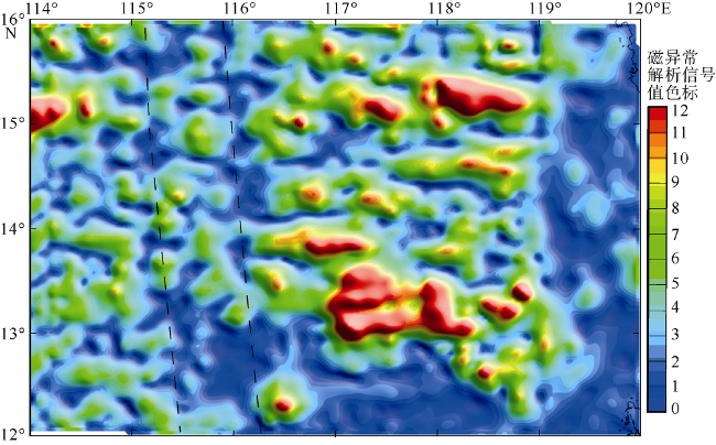
Fig. 7 Analytical signal module calculated from magnetic anomalies of the South China Sea Basin

图7 南海海盆磁异常解析信号模
黑色虚线为磁异常解析信号模过渡区

综上分析认为中南—礼乐断裂带是西北次海盆和东部次海盆北部, 西南次海盆与东部次海盆的边界, 推测该断裂带至少是一条地壳级断裂, 并可能对其东西两侧次海盆的洋壳厚度具有影响。

3.3 中南—礼乐断裂带的南北段连接

前期工作中, 姚伯初(1995)和Li等(2012, 2014)讨论了中南—礼乐断裂带的南北连接问题。姚伯初(1995)根据地壳厚度不同, 认为在西北次海盆和东部次海盆北部交界处存在一条大断裂; 在西南次海盆与东部次海盆交界处, 根据中南海山链反映断裂的走向, 认为该处存在一条南北向断裂; 在南沙群岛的礼乐海槽上, 根据地震剖面发现存在一条深大走滑断裂, 故其认为该断裂北起珠江海谷, 中经西南次海盆与东部次海盆交界, 南至南沙海槽, 是一条NS向的规模巨大的右旋走滑断裂(图1)。Li等(2012, 2014)根据海盆重磁异常特征, 认为在西北次海盆与东部次海盆北部、西南次海盆与东部次海盆之间存在一条NS向的协调大断裂。大部分学者(Barckhausen et al, 2004, 2014; 阎贫 等, 2008; Frank, 2013; Frank et al, 2014; Ruan et al, 2016; Sibuet et al, 2016)只讨论了该断裂带在西南次海盆和东部次海盆的分布特征。
本文根据最新地震剖面资料, 并结合重力、磁力、地形等地球物理资料, 分别讨论了该断裂在西北次海盆和东部次海盆北部及西南次海盆和东部次海盆的展布特征。对于该断裂带南北两段过渡区如何连接, 由于资料的有限, 目前只根据磁力和重力异常资料对断裂展布特征进行分析。磁异常平面图上(图3), 东侧磁异常呈近EW向, 表现为高值正负异常相间, 磁异常条带狭长, 西侧磁异常为低值正异常, 磁异常条带宽缓, 推测在东西两侧磁异常变换处存在一条断裂呈NNE向的展布。空间重力异常图上, 东侧表现为低值正异常, 西侧为低值负异常(图4), 推测在东西两侧重力异常变换处存在一条断裂呈NNE向的展布。结合重磁异常分析结果, 推测该断裂带在过渡区总体呈NNE向的展布特征。该断裂带在过渡区的内部形变特征及深部结构特征如何, 还有待更多翔实的资料以进行进一步深入研究。

4 结论

通过对穿越南海海盆中南—礼乐断裂带的最新地震剖面的剖析, 并结合重力、磁力与地形等地球物理资料, 厘定了南海海盆的内部边界(即中南—礼乐断裂带)的空间展布特征, 刻画了该断裂带内部构造形变特征, 并对该断裂带的深部结构, 断裂带对东西两侧海盆地质构造的影响及南北两段连接进行了探讨, 取得以下认识:
1) 中南—礼乐断裂带在南海海盆中由北至南无论在宽度、走向和内部变形特征上都差异明显。北段(西北次海盆与东部次海盆北部之间)断裂带宽约15km, 为一窄条带, 由(18°00'N, 115°30'E)向(17°30'N, 116°00'E)呈NNW向分布, 内部构造变形相对简单, 基底起伏平缓, 早期正断裂发育少。南段(西南次海盆与东部次海盆之间)断裂带宽约60~80km, 由中沙海台东侧(16°00'N, 115°30')向礼乐地块西侧(12°00'N, 116°30'E)呈NNW向展布, 内部构造变形丰富, 基底起伏较大, 早期小断裂非常发育。中南—礼乐断裂带南段的主控断裂主要沿中南海岭呈NNW向分布。该断裂带在南北两段的过渡区总体呈NNE向展布。
2) 中南—礼乐断裂带内的沉积物厚度比两侧次海盆的沉积物厚, 根据该断裂带两侧次海盆沉积厚度和洋壳厚度的明显差异, 推测中南—礼乐断裂带对其东西两侧的次级海盆的沉积厚度和洋壳都具有控制作用。
3) 深部结构上, 该断裂带在北段地震剖面上断穿沉积基底至上地壳反射面, 结合南段西南次海盆与东部次海盆磁异常的解析信号模结果和沿主控断裂发育的海山的岩浆来源分析, 推测中南—礼乐断裂带至少是一条地壳级断裂, 甚至可能断穿岩石圈。
*非常感谢姚伯初教授、姚永坚教授、孙珍研究员和杨小秋博士的有益讨论和帮助, 三位审稿专家的建设性修改意见及编辑部老师耐心指导修改。

The authors have declared that no competing interests exist.

[1]
JONES E J W, 2009. 海洋地球物理[M]. 金翔龙, 赵俐红, 孙鹏,等, 译. 北京:海洋出版社: 446-450.

JONES E J W, 2009. Marine geophysics[M]. JIN XIANGLONG, ZHAO LIHONG, SUNPENG, et al. Beijing: Ocean Press: 446-450 (in Chinese).

[2]
李家彪, 丁巍伟, 高金耀, 等, 2011. 南海新生代海底扩张的构造演化模式: 来自高分辨率地球物理数据的新认识[J]. 地球物理学报, 54(12): 3004-3015.根据高分辨率重、磁测网数据的分析,结合多波束海底地貌的构造解释,南海海盆新生代经历了两期不同动力特征的海底扩张,25 Ma的沉积-构造事件是其重要分界.早期扩张从约33.5 Ma开始至25 Ma停止,在东部海盆南、北两侧和西北海盆形成了具有近E-W向或NEE向磁条带的老洋壳,是近NNW-SSE向扩张的产物;晚期扩张从25 Ma开始至16.5 Ma结束,在东部海盆中央区和西南海盆形成了具有NE向磁条带的新洋壳,是NW-SE向扩张的产物.南海海盆分区特点明显,南北分区,东西分段.从南到北可进一步分为3个亚区,南、北亚区由早期扩张产生,而晚期扩张的中央亚区从东到西又可进一步分为6个洋段,中间均由NNW或NW向断裂分割,是扩张中脊分段性的表现.南海晚期扩张具有渐进式扩张的特点,虽然它们均于磁条带异常C5c停止扩张,但开始扩张的时间从东部的C6c(23.5 Ma),到中部的C6b(22.8 Ma),一直变新到西部的C5e(18.5 Ma).东部海盆与西南海盆之间的NNW向断裂是分割两海盆的边界断裂,不仅切割了磁条带异常,控制了两海盆不同的地球物理场特征,而且还使扩张中脊左行平移约95km,造成扩张中心和磁条带不连续.南海海盆扩张期间,其东部没有菲律宾群岛封闭,当时是一个面向大洋的港湾,与亚丁湾洋盆可以对比,是洋中脊向大陆边缘入侵的产物.

DOI

LI JIABIAO, DING WEIWEI, GAO JINYAO, et al, 2011. Cenozoic evolution model of the sea-floor spreading in South China Sea: new constraints from high resolution geophysical data[J]. Chinese Journal of Geophysics, 54(12): 3004-3015 (in Chinese with English abstract).

[3]
黎雨晗, 刘海龄, 朱荣伟, 等, 2017. 南海中南—司令断裂带的延伸特征及其与南海扩张演化的关系[J]. 海洋地质与第四纪, 37(2): 82-98.为了确定中南—司令断裂带在南海海盆及其在南部陆缘的延伸位置,并探讨其与南海扩张的关系,本文利用重磁异常、地震、莫霍面深度、P波速度特征、钻井拖网资料,对中南—司令断裂带的延伸位置进行了综合地质和地球物理研究,厘定了中南—司令断裂带在东部次海盆与西南、西北次海盆之间呈NS向延伸,并南延至南海南部陆缘之上,深度上切割至莫霍面。根据南海海盆中磁异常条带走向的变化,及磁异常条带、走滑/转换断裂、扩张方向的印证关系,结合前人对古南海"剪刀状"碰撞闭合、南海扩张演化、构造应力场的研究,提出在32~25 Ma,伴随着南海东部次海盆的NNW向扩张,南海海盆及南沙地块整体发生顺时针旋转,使中南—司令断裂走向由形成初期的NNW向转变为N—S向;23.5 Ma之后,顺时针旋转停止,南海东部次海盆继续NNW向扩张,西南次海盆呈NW—SE向渐进式扩张。作为一条切穿地壳的深大断裂,中南—司令断裂与红河-越东断裂、马尼拉海沟断裂三条深大断裂一起组成区域"滑线场",制约南海海盆的扩张与南沙地块的南移。

LI YUHAN, LIU HAILING, ZHU RONGWEI, et al, 2017. Extension of the Zhongnan-siling fault zone in South China Sea and its bearing on seafloor spreading[J]. Marine Geology & Quaternary Geology, 37(2): 82-98 (in Chinese with English abstract).

[4]
王叶剑, 韩喜球, 罗照华, 等, 2009. 晚中新世南海珍贝—黄岩海山岩浆活动及其演化: 岩石地球化学和年代学证据[J]. 海洋学报, 31(4): 93-102.南海海盆15°N附近呈东西向展布的珍贝-黄岩海山被认为是32-17 Ma前南海海盆的残留扩张中心。对采自黄岩海山的两个火山岩样品(9DG,9DG-2)进行了岩石学、地球化学和年代学研究。两个样品的SiO2含量分别为60.3%和63.6%,Al2O3含量分别为17.56%和17.55%,TiO2含量分别为0.48%和0.31%,碱度率分别为3.88和3.62。根据岩石学和岩石化学分类,样品属碱性系列的粗面岩。对稀土元素和微量元素分析表明岩石具有洋岛玄武岩(OIB)型配分型式,轻重稀土总量比(∑c(LREE)/∑c(HREE))和球粒陨石标准化镧镱比((La/Yb)N)分别高达17.22和27.23,并具有铕负异常和锶、磷、钛亏损的特点。样品9DG的锶-钕-铅同位素分析结果为锶-87的含量与锶-86的含量之比值为0.704 183,钕-143的含量与钕-144的含量之比值为0.512 827,铅-206的含量与铅-207的含量之比值为18.686 68,铅-207的含量与铅-204的含量之值为15.679 62,铅-208的含量与铅-204的含量之比值为39.002 61,表明初始岩浆来自软流圈地幔,具有与珍贝海山玄武岩相似的同位素组成。经钾-氩法测年,粗面岩的年龄为(7.77±0.49)Ma,略晚于珍贝海山玄武岩的年龄[(9.1±1.29)-(10.0±1.80)Ma],属于南海扩张期后晚中新世火山活动的产物。对比珍贝海山玄武岩的地球化学和同位素特征,认为两者有相同的岩浆源区,但是它们经历了不同程度的结晶分异过程,在晚中新世期间珍贝-黄岩海山可能有地幔柱活动。

DOI

WANG YEJIAN, HAN XIQIU, LUO ZHAOHUA, et al, 2009. Late Miocene magmatism and evolution of Zhenbei-Huangyan Seamount in the South China Sea: evidence from petrochemistry and chronology[J]. Acta Oceanologica Sinica, 31(4): 93-102 (in Chinese with English abstract).

[5]
阎贫, 王彦林, 刘海龄, 2008. 南海海盆地形与NW向断裂[J]. 热带海洋学报, 27(3): 30-37.新的2'×2'卫星测高获得的水深数据表明,除了在南海中央海盆 扩张脊附近分布有高耸、断续的近东西向海山链外,在南海深海平原上还存在一些北西向的连续线状凸起特征.这些线状特征高约500m,宽10-30km,绵 延数百至近千公里.反射地震数据则显示,这些海底线状隆起实际上是宽50-100km的走滑断裂带,在该断裂带内还有一些低幅和隐伏褶皱,它们代表了海盆 内部的压性走滑断裂带,反映了海盆扩张停止后台湾-吕宋岛弧向西的构造挤压应力对南海海盆的持续作用.其中一条穿过116°E的北北西向断裂带构成了中央 海盆与西南海盆的边界断裂.

DOI

YAN PIN, WANG YANLIN, LIU HAILING, 2008. Topography of oceanic basin in South China Sea and NW-directed faults[J]. Journal of Tropical Oceanography, 27(3): 30-37 (in Chinese with English abstract).

[6]
杨胜雄, 邱燕, 朱本铎, 2015. 南海地质地球物理图系[M]. 天津: 中国航海图书出版社.

YANG SHENGXIONG, QIU YAN, ZHU BENDUO, 2015. Atlas of geology and geophysics of the South China Sea[M]. Tianjin: China Navigation Publications (in Chinese).

[7]
姚伯初, 曾维军, HAYES D E, 等, 1994. 中美合作调研南海地质专报[M]. 武汉: 中国地质大学出版社.

YAO BOCHU, ZENG WEIJUN, HAYES D E, et al, 1994. The geological memoir of South China Sea surveyed jointly by China & USA[M]. Wuhan: China University of Geosciences Press (in Chinese).

[8]
姚伯初, 1995. 中南—礼乐断裂的特征及其构造意义[J]. 南海地质研究, (7): 1-14.据中南-礼乐断裂的地形地貌、地球物理场、地壳结构及剖面特征,作者认为它是一条右旋走滑断层。它北起珠江海谷之出口处,经南海中央海盆西缘、中南链状海山、礼乐海槽,直至加里曼丹的沙巴地区,全长1700km。它是在南海中央海盆于32-17Ma以前的海底扩张中,礼乐-东北巴拉望地块南移时的边界走滑断层,其规模宏大,在南海新生代构造运动中具有十分重要的意义。

YAO BOCHU, 1995. Characteristics and tectonic meaning of Zhongnan-Liyue fault[J]. Geological Research of South China Sea, (7): 1-14 (in Chinese).

[9]
BARCKHAUSEN U, ENGELS M, FRANKE D, et al, 2014. Evolution of the South China Sea: revised ages for breakup and seafloor spreading[J]. Marine and Petroleum Geology, 58: 599-611.The continental breakup which gave way to the formation of the oceanic South China Sea (SCS) basin began in the latest Cretaceous in the northeastern SCS and propagated in southern and western direction over a long period of time, possibly more than 40 m.y. The seafloor spreading history of the South China Sea has been interpreted in different ways in the past and the debate over the correct timing of the major tectonic events continues. We review the different models that have been published and present a revised interpretation of seafloor spreading anomalies based on three datasets with documented high quality which cover all of the SCS but the northernmost and southernmost parts. We can precisely date the onset of seafloor spreading in the central part of the SCS at 32 Ma. After a ridge jump at 25 Ma spreading also began in the southwestern sub-basin and spreading ended at 20.5 Ma in the entire basin, followed by a phase of magmatic seamount formation mainly along the abandoned spreading ridge. Spreading rates vary from 56 mm/yr in the early stages to 72 mm/yr after the ridge jump to 80 mm/yr in the southwestern sub-basin. We find indications for a stepwise propagation of the seafloor spreading from northeast to southwest in segments bounded by major fracture zones. Seafloor spreading ended abruptly probably because the subduction zone along the eastern and southern boundary of the SCS (of which today the Manila Trench remains) was blocked by collision with a continental fragment, possibly the northern part of Palawan or a part of the Dangerous Grounds. (C) 2014 Elsevier Ltd. All rights reserved.

DOI

[10]
BARCKHAUSEN U, ROESER H A, 2004. Seafloor spreading anomalies in the South China Sea revisited[M]//CLIFT P, KUHNT W, WANG P, et al. Continent‐Ocean Interactions Within East Asian Marginal Seas. Washington: American Geophysical Union, 149: 121-125.

[11]
BRIAIS A, PATRIAT P, TAPPONNIER P, 1993. Updated interpretation of magnetic anomalies and seafloor spreading stages in the South China Sea: implications for the tertiary tectonics of Southeast Asia[J]. Journal of Geophysical Research: Solid Earth, 98(B4): 6299-6328.We present the interpretation of a new set of closely spaced marine magnetic profiles that complements previous data in the northeastern and southwestern parts of the South China Sea (Nan Hai). This interpretation shows that seafloor spreading was asymmetric and confirms that it included at least one ridge jump. Discontinuities in the seafloor fabric, characterized by large differences in basement depth and roughness, appear to be related to variations in spreading rate. Between anomalies 11 and 7 (32 to 27 Ma), spreading at an intermediate, average full rate of 09090850 mm/yr created relatively smooth basement, now thickly blanketed by sediments. The ridge then jumped to the south and created rough basement, now much shallower and covered with thinner sediments than in the north. This episode lasted from anomaly 6b to anomaly 5c (27 to 09090816 Ma) and the average spreading rate was slower, 09090835 mm/yr. After 27 Ma, spreading appears to have developed first in the eastern part of the basin and to have propagated towards the southwest in two major steps, at the time of anomalies 6b-7, and at the time of anomaly 6. Each step correlates with a variation of the ridge orientation, from nearly E-W to NE-SW, and with a variation in the spreading rate. Spreading appears to have stopped synchronously along the ridge, at about 15.5 Ma. From computed fits of magnetic isochrons, we calculate 10 poles of finite rotation between the times of magnetic anomalies 11 and 5c. The poles permit reconstruction of the Oligo-Miocene movements of Southeast Asian blocks north and south of the South China Sea. Using such reconstructions, we test quantitatively a simple scenario for the opening of the sea in which seafloor spreading results from the extrusion of Indochina relative to South China, in response to the penetration of India into Asia. This alone yields between 500 and 600 km of left-lateral motion on the Red River-Ailao Shan shear zone, with crustal shortening in the San Jiang region and crustal extension in Tonkin. The offset derived from the fit of magnetic isochrons on the South China Sea floor is compatible with the offset of geological markers north and south of the Red River Zone. The first phases of extension of the continental margins of the basin are probably related to motion on the Wang Chao and Three Pagodas Faults, in addition to the Red River Fault. That Indochina rotated at least 1200° relative to South China implies that large-scale 090008domino090009 models are inadequate to describe the Cenozoic tectonics of Southeast Asia. The cessation of spreading after 16 Ma appears to be roughly synchronous with the final increments of left-lateral shear and normal uplift in the Ailao Shan (18 Ma), as well as with incipient collisions between the Australian and the Eurasian plates. Hence no other causes than the activation of new fault zones within the India-Asia collision zone, north and east of the Red River Fault, and perhaps increased resistance to extrusion along the SE edge of Sundaland, appear to be required to terminate seafloor spreading in the largest marginal basin of the western Pacific and to change the sense of motion on the largest strike-slip fault of SE Asia.

DOI

[12]
DING WEIWEI, SUN ZHEN, DADD K, et al, 2018. Structures within the oceanic crust of the central South China Sea basin and their implications for oceanic accretionary processes[J]. Earth and Planetary Science Letters, 488: 115-125.Internal structures in mature oceanic crust can elucidate understanding of the processes and mechanism of crustal accretion. In this study, we present two multi-channel seismic (MCS) transects across the northern flank of the South China Sea basin to reveal the internal structures related to Cenozoic tectono-magmatic processes during seafloor spreading. Bright reflectors within the oceanic crust, including the Moho, upper crustal reflectors, and lower crustal reflectors, are clearly imaged in these two transects. The Moho reflection displays varied character in continuity, shape and amplitude from the continental slope area to the abyssal basin, and becomes absent in the central part of the basin where abundant seamounts and seamount chains formed after the cessation of seafloor spreading. Dipping reflectors are distinct in most parts of the MCS data but generally confined to the lower crust above the Moho reflection. These lower crustal reflectors merge downward into the Moho without offsetting it, probably arising from shear zones between the crust and mantle characterized by interstitial melt, although we cannot exclude other possibilities such as brittle faulting or magmatic layering in the local area. A notable feature of these lower crustal reflector events is their opposite inclinations. We suggest the two groups of conjugate lower crustal reflector events observed between magnetic anomalies C11 and C8 were associated with two unusual accretionary processes arising from plate reorganizations with southward ridge jumps.

DOI

[13]
FRANKE D, 2013. Rifting, lithosphere breakup and volcanism: Comparison of magma-poor and volcanic rifted margins[J]. Marine and Petroleum Geology, 43: 63-87.

DOI

[14]
FRANKE D, SAVVA D, PUBELLIER M, et al, 2014. The final rifting evolution in the South China Sea[J]. Marine and Petroleum Geology, 58: 704-720.61Moho uplifts are distinct beneath major rift basins.61Post-rift shallow-water platform carbonates indicate a subsidence deficit during rifting.61Symmetric initial rifting becomes asymmetric at the future COT.61Along-margin variations are suggested resulting in alternating “upper and lower plate” margins.

DOI

[15]
LI CHUNFENG, LIN JIAN, KULHANEK D K, et al, 2015. Expedition 349 summary[C]//Proceedings of the International Ocean Discovery Program. doi: 10.14379/iodp.proc.349.101. 2015.

[16]
LI CHUNFENG, SONG TAORAN, 2012. Magnetic recording of the Cenozoic oceanic crustal accretion and evolution of the South China Sea basin[J]. Chinese Science Bulletin, 57(24): 3165-3181.We review and discuss some of the recent scientific findings made on magnetic data in the South China Sea (SCS). Magnetic anomalies bear extremely rich information on Mesozoic and Cenozoic tectonic evolution. 3D analytical signal amplitudes computed from magnetic anomalies reveal very precisely relict distributions of Mesozoic sedimentary sequences on the two conjugate continental margins, and they are also found very effective in depicting later-stage magmatism and tectonic transitions and zonation within the SCS oceanic crust. Through integrated analyses of magnetic, gravity and reflection seismic data, we define the continent-ocean boundary (COB) around the South China Sea continental margin, and find that the COB coincides very well with a transition zone from mostly positive to negative free-air gravity anomalies. This accurate outlining of the COB is critical for better tracing magnetic anomalies induced by the oceanic crust. The geometrically complex COB and inner magnetic zonation require the introduction of an episodic opening model, as well as a transform fault (here coined as Zhongnan Fault) between the East and Southwest Sub-basins, while within the East and Southwest Sub-basins, magnetic anomalies are rather continuous laterally, indicating nonexistence of large transform faults within these sub-basins. We enhance magnetic anomalies caused by the shallow basaltic layer via a band-pass filter, and recognize that the likely oldest magnetic anomaly near the northern continental margin is C12 according to the magnetic time scale CK95. Near the southern continental margin, magnetic anomalies are less recognizable and the anomaly C12 appears to be missing. These differences show an asymmetrical opening style with respect to the relict spreading center, and the northern part appears to have slightly faster spreading rates than to the south. The magnetic anomalies C8 (M1 and M2, ~26 Ma) represent important magnetic boundaries within the oceanic basin, and are possibly related to changes in spreading rates and magmatic intensities. The magnetic evidence for a previously proposed ridge jump after the anomaly C7 is not clear. The age of the Southwest Sub-basin has yet to be further examined, most favorably with deep-tow magnetic surveys and ocean drilling. Our magnetic spectral study shows that the shallowest Curie points are located around the eastern part of the Southwestern Sub-basin, whereas within the East Sub-basin Curie depths are smaller to the north of the relict spreading center than to the south. This pattern of Curie depths is consistent to regional heat flow measurements and later-stage volcanic seamount distributions, and we therefore reason that Curie-depth variations are closely associated with later-stage magmatism, rather than with crustal ages. Although magnetic anomalies located around the northern continent-ocean transition zone (COT) are relatively quiet, this area is not a typical magnetic quiet zone since conceptually it differs markedly from an oceanic magnetic quiet zone. The relatively quiet magnetic anomalies are seemingly associated with a shallowing in Curie isotherm and thinning in magnetic layer, but our comprehensive observations suggest that the well-preserved thick Mesozoic sedimentary rocks are major causes for the magnetically quiet zone. The high similarities between various low-pass filtered marine and air-borne magnetic anomalies and satellite magnetic anomalies clearly confirm that deeper magnetic sources (in the lower crust and the uppermost mantle) have contributions to long-wavelength surface magnetic anomalies in the area, as already inferred from magnetically inversed Curie depths. The offshore south China magnetic anomaly (SCMA) becomes more prominent on low-pass filtered marine and air-borne magnetic anomalies and satellite magnetic anomalies, indicating very deeply-buried magnetic sources beneath it.

DOI

[17]
LI CHUNFENG, XU XING, LIN JIAN, et al, 2014. Ages and magnetic structures of the South China Sea constrained by deep tow magnetic surveys and IODP Expedition 349[J]. Geochemistry, Geophysics, Geosystems, 15(12): 4958-4983.Abstract Combined analyses of deep tow magnetic anomalies and International Ocean Discovery Program Expedition 349 cores show that initial seafloor spreading started around 33 Ma in the northeastern South China Sea (SCS), but varied slightly by 1–2 Myr along the northern continent-ocean boundary (COB). A southward ridge jump of 6520 km occurred around 23.6 Ma in the East Subbasin; this timing also slightly varied along the ridge and was coeval to the onset of seafloor spreading in the Southwest Subbasin, which propagated for about 400 km southwestward from 6523.6 to 6521.5 Ma. The terminal age of seafloor spreading is 6515 Ma in the East Subbasin and 6516 Ma in the Southwest Subbasin. The full spreading rate in the East Subbasin varied largely from 6520 to 6580 km/Myr, but mostly decreased with time except for the period between 6526.0 Ma and the ridge jump (6523.6 Ma), within which the rate was the fastest at 6570 km/Myr on average. The spreading rates are not correlated, in most cases, to magnetic anomaly amplitudes that reflect basement magnetization contrasts. Shipboard magnetic measurements reveal at least one magnetic reversal in the top 100 m of basaltic layers, in addition to large vertical intensity variations. These complexities are caused by late-stage lava flows that are magnetized in a different polarity from the primary basaltic layer emplaced during the main phase of crustal accretion. Deep tow magnetic modeling also reveals this smearing in basement magnetizations by incorporating a contamination coefficient of 0.5, which partly alleviates the problem of assuming a magnetic blocking model of constant thickness and uniform magnetization. The primary contribution to magnetic anomalies of the SCS is not in the top 100 m of the igneous basement.

DOI

[18]
LI CHUNFENG, ZHOU ZUYI, LI JIABIAO, et al, 2008. Magnetic zoning and seismic structure of the South China Sea ocean basin[J]. Marine Geophysical Researches, 29(4): 223-238.

DOI

[19]
RUAN AIGUO, WEI XIAODONG, NIU XIONGWEI, et al, 2016. Crustal structure and fracture zone in the Central Basin of the South China Sea from wide angle seismic experiments using OBS[J]. Tectonophysics, 688: 1-10.We present twoE-W trending wide-angle seismic profiles (OBS2013-ZN, OBS2014-ZN), which cross the boundary (Zhongnan fault zone) between the east sub-basin and the southwest sub-basin of the South China Sea (SCS). We processed the data and used 2D ray-tracing to determine the oceanic crust thickness, velocity structures and Moho depth variations related to the fault zone. The simulated velocity models show that the oceanic basin of the SCS has a typical oceanic crust covered by a 1–2km thick sediment layer with a velocity of 2.0–3.5km/s. The crust has a thickness of 5–8km, of which the oceanic layer 2 is 1.8–3km thick, with velocity increasing downward from 4.3km/s to 6.4km/s, and the oceanic layer 3 is 3–5km thick, with velocity increasing downward from 6.4km/s-7.0km/s. The Moho depth in the oceanic basin is approximately 6–7km below seabed. The Moho discontinuity has a prominent upheaval zone with a low velocity of 7.6km/s, whose location corresponds to the low velocity zone in oceanic layer 2. Our results suggest the presence of a NW-SE-trending fracture zone (40–60km wide) rather than a major “Zhongnan fault” oriented NS by connecting the upheaval portions of the Moho in the two profiles. The NW-SE orientation Zhongnan transform fault zone in our study area is consistent with the direction of opening of the South China Sea in the last stage of its evolution. This large transform fault zone connected and offset the spreading centers of the east and southwest sub-basin.

DOI

[20]
SCHLÜTER H U, HINZ K, BLOCK M, 1996. Tectono- stratigraphic terranes and detachment faulting of the South China Sea and Sulu Sea[J]. Marin Geology, 130(1-2): 39-51, 58-78.The leading edge of the southward drifting continental terranes collided with the Late Cretaceous to Early Eocene subduction complex of the northernmost terrane of the proto-Sulu Sea. Continuous convergence of these terranes, back-arc spreading creating the SE Sulu Sea terrane and the assumed anti-clockwise rotation of Borneo are responsible for the complex collision-compression structures of the Sulu Sea terranes, including the formation of splinters of oceanic crust. Major right-lateral wrench systems are NNW-SSE running, up to 500 km long and cut across most of the identified terranes. Wrenching presumably ceased 12 to 16 Myr ago.

DOI

[21]
SIBUET J C, YEH Y C, LEE C S, 2016. Geodynamics of the South China Sea[J]. Tectonophysics, 692: 98-119.

DOI

[22]
TAYLOR B, HAYES D E, 1980. The tectonic evolution of the South China Basin[M]//HAYES D E. The Tectonic and Geologic Evolution of Southeast Asian Seas and Islands. Washington: American Geophysical Union, 23: 89-104.

[23]
TAYLOR B, HAYES D E, 1983. Origin and history of the South China Sea basin[M]//HAYES D E. The Tectonic and Geologic Evolution of Southeast Asian Seas and Islands: Part 2. Washington: American Geophysical Union, 27: 23-56.

[24]
TONGKUL F, 1993. Tectonic control on the development of the Neogene basins in Sabah, East Malaysia[C]//Proceedings Symposium on the Tectonic Framework and Energy Resources of the Western Margin of the Pacific Basin. Kuala Lumpur, Malaysia: Geological Society of Malaysia: 95-103.

[25]
TONGKUL F, 1994. The geology of northern Sabah, Malaysia: its relationship to the opening of the South China Sea basin[J]. Tectonophysics, 235(1-2): 131-147.The northern part of Sabah, consisting of sedimentary and igneous rocks of Early Cretaceous to Pliocene age, has experienced three major episodes of deformation associated with NW-SE and N-S oriented compressions. The earliest episode deformed and uplifted an oceanic basement (Chert-Spilite Formation) to form an elongate basin, trending approximately NE-SW, during the Late Cretaceous to Early Eocene. This elongate basin became the site for the deposition of middle Eocene to Early Miocene quartzose sediments of the Crocker and Kudat formations, sourced from continental basement towards the southwest and north, respectively. These sediments were subsequently deformed by a second episode of deformation associated with NW-SE and N-S oriented compressions, during the latter part of the late Oligocene and the early Middle Miocene, to form a series of imbricate thrust slices. The N-S trending compressive direction controlled the development of approximately E-W trending basins during the deposition of the Upper Miocene sediments of the South Banggi and Bongaya formations. The continuation of N-S compression, which represents the third episode of deformation, gently deformed these sediments. The three episodes of deformation were related to the differential southward movements of continental blocks separated from the southern margin of China during the intermittent opening of the South China Sea subbasins. The first episode was related to the opening of the Southwest Subbasin, while the second episode was related to both the opening of the Southwest and East subbasins. The third episode was related to continued opening in the East Subbasins.

DOI

Outlines

/