

热带海洋学报 ›› 2026, Vol. 45 ›› Issue (4): 77-88.doi: 10.11978/2025235CSTR: 32234.14.2025235
基于Sentinel-2的平陆运河出海口红树林动态变化特征
梁喜幸1,2,3( ), 戴志军3(), 李焰1, 黎树式2, 李为华3, 王日明2, 吴尔江1
- 1
广西壮族自治区海洋研究院
2北部湾大学 ,广西海洋环境灾害过程与生态保护技术重点实验室
3华东师范大学 ,河口海岸全国重点实验室
-
收稿日期:2025-12-08修回日期:2025-12-26出版日期:2026-07-10发布日期:2026-07-31 -
通讯作者:戴志军(1973—), 男, 教授, 主要研究方向为河口海岸动力地貌模拟及模式预测、红树林生态修复及海岸绿色堤防。email: zjdai@sklec.ecnu.edu.cn -
作者简介:梁喜幸(1988—), 男, 博士, 主要研究方向为河口海岸动力沉积地貌过程。email: liangxixing.ok@163.com
-
基金资助:国家重点研发计划政府间国际科技创新合作重点专项(2023YFE0121200); 上海市国际科技合作基金项目(23230713800); 国家自然科学基金(42366008); 2025年度广西科技界智库重点课题(Gui Kexie〔2025〕J-004)
Spatiotemporal dynamics of mangroves at the Pinglu Canal estuary based on Sentinel-2
LIANG Xixing1,2,3(), DAI Zhijun3(), LI Yan1, LI Shushi2, LI Weihua3, WANG Riming2, WU Erjiang1
- 1
Guangxi Academy of Oceanography
2Guangxi Key Laboratory of Marine Environmental Disaster Processes and Ecological Protection Technology ,Beibu Gulf University
3State Key Laboratory of Estuarine and Coastal Research ,East China Normal University
-
Received:2025-12-08Revised:2025-12-26Online:2026-07-10Published:2026-07-31 -
Contact:DAI Zhijun. email: zjdai@sklec.ecnu.edu.cn -
Supported by:Key Special Project for International Cooperation in Science and Technology under the National Key Research and Development Program of China(2023YFE0121200); Shanghai International Science and Technology Cooperation Fund Project(23230713800); National Natural Science Foundation of China(42366008); Key Research Topics for the Guangxi Science and Technology Community in 2025(Gui Kexie〔2025〕J-004)

摘要:
平陆运河出海口位于茅尾海北部, 是典型的受强烈人类活动干扰的红树林潮滩区域。本文基于遥感影像和GeoAI (geospatial artificial intelligence)深度学习框架, 采用U-Net模型定量提取平陆运河出海口红树林的时空变化特征, 并系统分析水动力作用、生蚝养殖、船舶密度及促淤消浪工程对红树林演变过程的综合影响。结果表明: 2016—2025年期间平陆运河出海口红树林面积总体呈下降趋势, 平均缩减速率为6.69hm2·a-1, 其中2021—2023年侵蚀速率明显加快, 面积缩减速率由2021年之前的3.39hm2·a-1增至16.30hm2·a-1, 红树林边缘以-4.89m·a-1的速率后退, 而后2023—2025年面积损失速率减缓至5.75hm2·a-1, 蚀退速率降至-3.69m·a-1, 侵蚀区域主要分布在河道两侧。研究表明, 船舶密度增大、蚝排移除等人类活动叠加效应是驱动红树林退化的主要原因, 而生态型促淤消浪工程可有效提升红树林岸线的稳定性, 减缓红树林受损过程。研究成果为运河航道建设与红树林生态保护协调发展提供关键支撑。
中图分类号:
- P714
引用本文
梁喜幸, 戴志军, 李焰, 黎树式, 李为华, 王日明, 吴尔江. 基于Sentinel-2的平陆运河出海口红树林动态变化特征[J]. 热带海洋学报, 2026, 45(4): 77-88.
LIANG Xixing, DAI Zhijun, LI Yan, LI Shushi, LI Weihua, WANG Riming, WU Erjiang. Spatiotemporal dynamics of mangroves at the Pinglu Canal estuary based on Sentinel-2[J]. Journal of Tropical Oceanography, 2026, 45(4): 77-88.
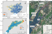
图 1
研究区域概况图 a. 研究区域在广西的地理位置; b. 钦江流域; 图a、b基于自然资源部标准地图服务网站下载的审图号为GS(2023)2766号的标准地图制作; c. 研究区域范围及红树林边缘线变化特征提取断面分布"

图 1

表 1
遥感影像信息及对应潮位"
| 序号 | 成像日期 | 卫星 | 潮位/m | 地面分辨率/m |
|---|---|---|---|---|
| 1 | 2016-04-16 | Sentinel-2 MSI | 0.96 | 10 |
| 2 | 2017-04-01 | Sentinel-2 MSI | 2.39 | 10 |
| 3 | 2018-12-17 | Sentinel-2 MSI | 2.17 | 10 |
| 4 | 2019-09-13 | Sentinel-2 MSI | 2.11 | 10 |
| 5 | 2020-11-26 | Sentinel-2 MSI | 2.21 | 10 |
| 6 | 2021-10-07 | Sentinel-2 MSI | 1.70 | 10 |
| 7 | 2022-12-21 | Sentinel-2 MSI | 1.52 | 10 |
| 8 | 2023-11-26 | Sentinel-2 MSI | 1.96 | 10 |
| 9 | 2024-11-30 | Sentinel-2 MSI | 2.13 | 10 |
| 10 | 2025-07-28 | Sentinel-2 MSI | 1.57 | 10 |
表 1
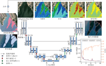
图 2
基于U-Net模型提取红树林的架构及模型训练精度 图中ReLU(rectified linear unit)为修正线性单元"

图 2
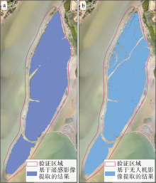
图 3
红树林提取精度验证 a. 利用训练的模型从Sentinel-2影像提取的红树林, 遥感影像过境时间为2022年12月21日; b. 利用训练的模型从无人机影像提取的红树林, 航测时间为2022年8月16日"

图 3
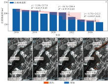
图 4
平陆运河出海口红树林时空变化特征 a. 红树林面积变化过程; b—e. 红树林得失空间分布"

图 4
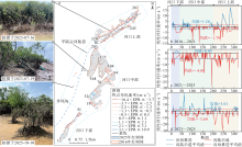
图 5
研究区域红树林边缘线整体变化趋势 a. 2016—2025年红树林边缘线终点变化速率(单位: m·a-1)空间分布特征; b—d. 2016—2021年、2021—2023年和2023—2025年红树林边缘线变化特征"

图 5
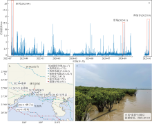
图 6
研究区域波浪及台风影响情况 a. 平陆运河出海口2023年7月至2025年10月有效波高变化特征; b. 2016—2025年期间影响研究区域的台风路径及强度; c. 台风“泰利(202304)”过境之后研究区域红树林状态"
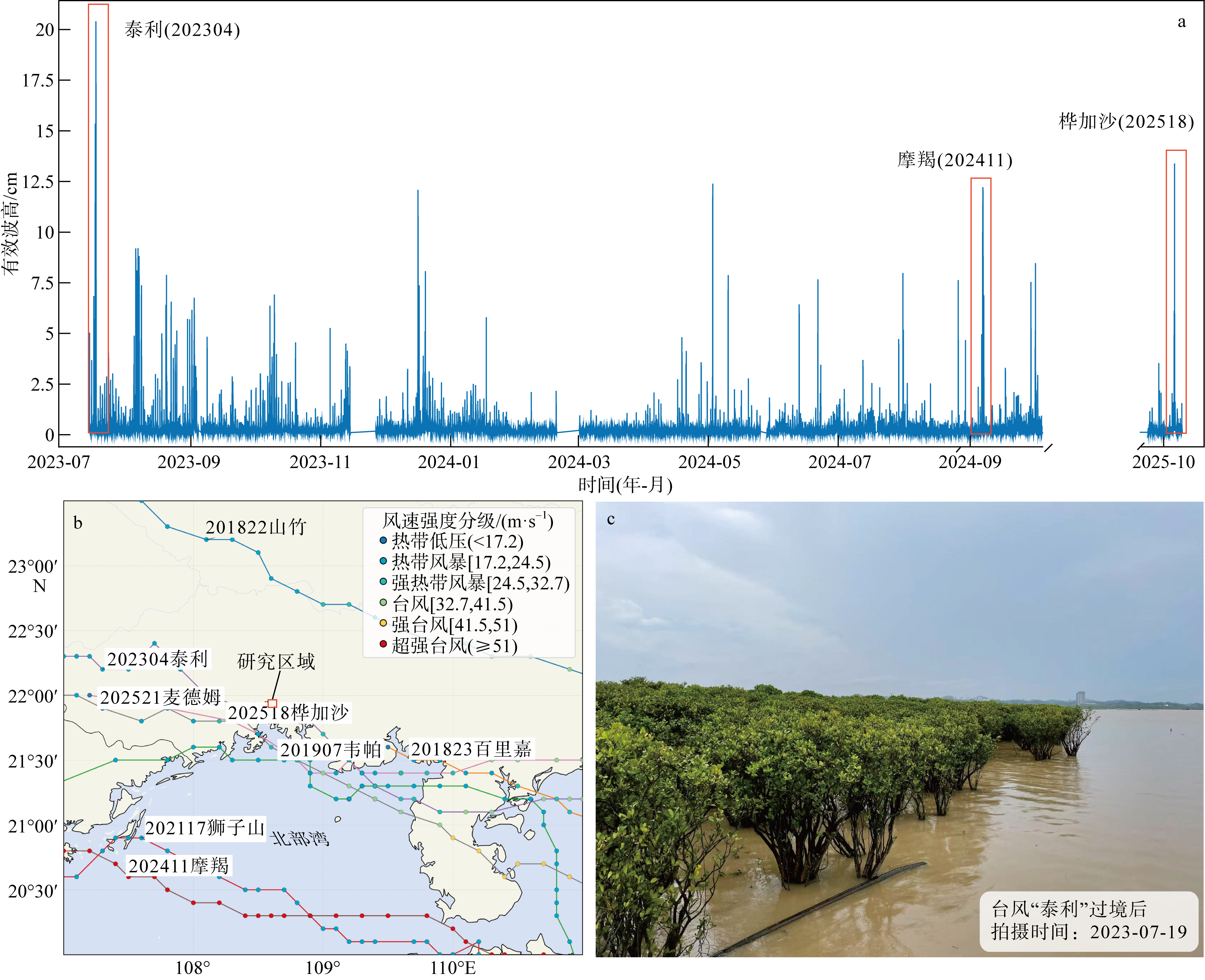
图 6
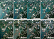
图 7
平陆运河出海口蚝排时空分布特征"

图 7
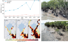
图 8
平陆运河出海口船舶密度变化趋势 a. 平陆运河出海口所有船型和服务船密度变化趋势; b—d. 船舶密度空间分布; e—f. 船舶行驶产生的波浪"

图 8
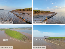
图 9
竹栅栏消浪促淤工程实施前(a—b)、后(c—d)对比"

图 9
| [1] |
戴志军, 周晓妍, 王杰, 等, 2021. 红树林潮滩沉积动力研究进展与展望[J]. 热带海洋学报, 40(3): 69-75.
doi: 10.11978/YG2020007 |
|
doi: 10.11978/YG2020007 |
|
| [2] |
冯炳斌, 王日明, 黎树式, 等, 2022. 钦州湾人工海滩剖面变化过程[J]. 热带海洋学报, 41(4): 51-60.
doi: 10.11978/2021096 |
|
doi: 10.11978/2021096 |
|
| [3] |
黄星, 辛琨, 李秀珍, 等, 2015. 基于斑块的东寨港红树林湿地景观格局变化及其驱动力[J]. 应用生态学报, 26(5):1510-1518.
pmid: 26571672 |
|
pmid: 26571672 |
|
| [4] |
黄雪松, 陈燕丽, 莫伟华, 等, 2021. 近60年广西北部湾红树林生态区气候变化及其影响因素[J]. 生态学报, 41(12): 5026-5033.
|
|
|
|
| [5] |
黎广钊, 梁文, 刘敬合, 2001. 钦州湾水下动力地貌特征[J]. 地理学与国土研究, (4): 70-75.
|
|
|
|
| [6] |
李树华, 方龙驹, 1989. 钦州湾潮汐和潮流的变化特征[J]. 海岸工程, 8(3): 39-45.
|
|
|
|
| [7] |
梁喜幸, 王日明, 戴志军, 等, 2023. 茅尾海钦江河口光滩时空变化过程研究[J]. 海洋地质与第四纪地质, 43(3): 107-118.
|
|
|
|
| [8] |
潘炜杰, 祝振昌, 蔡宴朋, 等, 2021. 潮滩冲淤扰动下外来与乡土红树植物幼苗稳定性差异[J]. 热带海洋学报, 40(6): 120-127.
doi: 10.11978/2020133 |
|
doi: 10.11978/2020133 |
|
| [9] |
任叙合, 何帅, 李保石, 2016. 茅尾海生态修复工程对冲淤影响的数值模拟研究[J]. 海洋湖沼通报, 38(6): 20-28.
|
|
|
|
| [10] |
王日明, 梁喜幸, 周晓妍, 等, 2022. 钦江河口潮滩红树林群落空间分布[J]. 遥感学报, 26(6): 1143-1154.
|
|
doi: 10.11834/jrs.20221540 |
|
| [11] |
谢小魁, 李兴荣, 王日明, 等, 2025. 北部湾茅尾海潮滩外来红树无瓣海桑时空演替[J]. 热带海洋学报, 44(6): 132-142.
|
|
|
|
| [12] |
doi: 10.1016/j.ecss.2007.08.024 |
| [13] |
doi: 10.1016/j.ecss.2019.106263 |
| [14] |
doi: 10.5194/essd-14-2445-2022 |
| [15] |
doi: 10.14324/111.444/ucloe.000057 pmid: 37229347 |
| [16] |
doi: 10.1038/s41598-019-44925-6 pmid: 31189886 |
| [17] |
doi: 10.1016/j.geomorph.2022.108484 |
| [18] |
doi: 10.1038/nclimate1970 |
| [19] |
doi: 10.3390/jmse8050325 |
| [20] |
|
| [21] |
|
| [22] |
doi: 10.3390/w15162884 |
| [23] |
doi: 10.1016/j.ecolmodel.2022.110230 |
| [24] |
doi: 10.1016/S0034-4257(02)00096-2 |
| [25] |
|
| [26] |
doi: 10.1016/j.scitotenv.2023.163475 |
| [27] |
doi: 10.1016/j.aquabot.2007.12.014 |
| [28] |
doi: 10.1111/nph.12605 pmid: 24251960 |
| [29] |
doi: 10.1038/s41467-021-24253-y pmid: 34183663 |
| [30] |
doi: 10.1080/01431169608948714 |
| [31] |
doi: 10.1038/ngeo2251 |
| [32] |
|
| [33] |
|
| [34] |
|
| [35] |
doi: 10.3389/fmars.2018.00164 |
| [36] |
doi: 10.1007/s12237-018-0463-y |
| [37] |
|
| [38] |
|
| [1] | 谢雨桐, 黄友菊, 田义超, 韩广萍, 张强, 陶进, 杜金泽, 彭子杰. 红树林三维结构和地上生物量激光点云反演[J]. 热带海洋学报, 2026, 45(4): 89-103. |
| [2] | 齐峰, 邓晓杰, 关永鹏, 周盛垚, 何庆, RAJAPAKSHALAGE Thashikala Nethmini, 李楠, 姜宫凌侠, 陈清香, 雷欣悦, 侯庆华, 黄来珍, 李小蕾, 韦巧艳. 红树植物秋茄根系固氮微生物群落的稳定性和复杂性及其关键影响因子研究[J]. 热带海洋学报, 2026, 45(3): 153-163. |
| [3] | 谭清碧, 郭泓瀛, 孙思旗, 钟宇航, 聂会, 牛丽霞. 稳定同位素示踪浙江清江口红树林沉积物氮源及其影响因子分析[J]. 热带海洋学报, 2026, 45(3): 202-211. |
| [4] | 方扬, 唐俊逸, 罗育池, 叶匡旻, 邓炜华. 外来红树引入对生态系统健康与服务功能的影响——以广东省3个典型区域为例[J]. 热带海洋学报, 2026, 45(2): 173-190. |
| [5] | 蒋守殿, 胡鑫, 蓝珮心, 姚李勤, 水柏年, 纪建达, 何茂求. 浙江西门岛红树林细菌群落季节性特征及环境驱动因素[J]. 热带海洋学报, 2026, 45(2): 117-128. |
| [6] | 粟春青, 高育慧, 罗炘武, 韩梦梦, 宫彦章, 郑卫国. 深圳不同红树林群落生物量和碳储量[J]. 热带海洋学报, 2025, 44(6): 155-164. |
| [7] | 王日明, 苏金恒, 戴志军, 吴天亮, 谢晓雯, 黄春梅, 李兴荣, 张尚宇. 钦州湾茅岭江河口红树林湿地动态变化过程[J]. 热带海洋学报, 2025, 44(6): 143-154. |
| [8] | 谢小魁, 李兴荣, 王日明, 戴志军, 龚受基, 庞文鸿, 张尚宇. 北部湾茅尾海潮滩外来红树无瓣海桑时空演替[J]. 热带海洋学报, 2025, 44(6): 132-142. |
| [9] | 刘太龙, 谢涛, 李建, 王超, 张雪红. 基于深度学习的SAR图像海洋涡旋自动检测模型[J]. 热带海洋学报, 2025, 44(5): 65-76. |
| [10] | 胡鑫, 熊兰兰, 陈顺洋, 张黄琛, 邹易阳, 张吉超, 刘东熙, 何佳潞, 吴于琪, 朱振杰. 幼龄红树生物量模型及幼林红树林碳储量研究*[J]. 热带海洋学报, 2025, 44(4): 187-199. |
| [11] | 田蜜, 钟才荣, 吕晓波, 方赞山, 黄丹慜. 东寨港不同退塘还林模式红树林群落特征比较[J]. 热带海洋学报, 2025, 44(3): 58-65. |
| [12] | 李天阔, 屈科, 李晓涵, 王傲宇, 王超. 半潜式浮式风机基础水动力特性及系泊系统张力特性预测[J]. 热带海洋学报, 2025, 44(3): 36-47. |
| [13] | 袁羽杰, 钟仕全, 蒋卫国, 初爱萍, 凌子燕. 基于环境减灾二号卫星的2023年铁山港红树林病虫害动态监测[J]. 热带海洋学报, 2025, 44(3): 188-196. |
| [14] | 刘思妮, 白猛, 朱义广, 罗小卫, 高程海, 刘永宏, 徐新亚, 蒋晓东. 红树林来源链霉菌中2-羟基苯基噻唑啉衍生物及其生物合成基因簇分析[J]. 热带海洋学报, 2025, 44(2): 64-72. |
| [15] | 吴雪, 赵鑫, 辜伟芳, 朱科桦, 葛振鸣. 浙南海岸带人工秋茄(Kandelia obovata)红树林与互花米草(Spartina alterniflora)盐沼土壤碳汇对比研究[J]. 热带海洋学报, 2025, 44(1): 172-181. |
|
||