

热带海洋学报 ›› 2026, Vol. 45 ›› Issue (4): 89-103.doi: 10.11978/2025155CSTR: 32234.14.2025155
红树林三维结构和地上生物量激光点云反演
谢雨桐1( ), 黄友菊2, 田义超1,3,4,5,6(), 韩广萍3, 张强1, 陶进1, 杜金泽1, 彭子杰1
- 1
北部湾大学 ,海洋学院/资源与环境学院
2热带海洋生态系统与生物资源重点实验室(自然资源部第四海洋研究所)
3广西壮族自治区自然资源遥感院
4平陆运河河口海湾生态系统广西野外科学观测研究站 ,广西海洋环境灾害过程与生态保护技术重点实验室(北部湾大学)
5北部湾大学 ,北部湾海洋地理信息资源开发利用重点实验室
6北部湾大学 ,北部湾海洋发展研究中心
-
收稿日期:2025-09-01修回日期:2025-09-09出版日期:2026-07-10发布日期:2026-07-31 -
通讯作者:田义超(1986—), 教授, 广西八桂青年学者, 主要从事喀斯特与海岸带水文生态过程方面的研究。email: tianyichao1314@yeah.net -
作者简介:谢雨桐(1997—), 男, 硕士生, 主要研究方向为海洋定量遥感和红树林生态系统服务。email: 1027587908@qq.com
*感谢匿名审稿专家和编辑提供宝贵意见和建议
-
基金资助:国家自然科学基金项目(42261024); 自然资源部热带海洋生态系统与生物资源重点实验室(2023ZD06); 广西八桂青年拔尖人才(八桂青年学者); 广西林业厅项目(Guilin scientific research [2022] no. 4); 北部湾大学海洋科学高原学科(DRB003); 广西高校人文社会科学重点研究基地“北部湾海洋发展研究中心”(BHZKY2202); 广西高校人文社科重大项目(JDZD202214); 北部湾大学高层次人才引进项目(2019KYQD28); 广西研究生教育创新计划项目(YCSW2025623)
Laser point cloud inversion of three-dimensional structure and aboveground biomass of mangroves*
XIE Yutong1(), HUANG Youju2, TIAN Yichao1,3,4,5,6(), HAN Guangping3, ZHANG Qiang1, TAO Jin1, DU Jinze1, PENG Zijie1
- 1
College of Marine Sciences/College of Resources and Environment ,Beibu Gulf University
2Key Laboratory of Tropical Marine Ecosystems and Biological Resources ,Fourth Institute of Oceanography, Ministry of Natural Resources
3Guangxi Zhuang Autonomous Region Remote Sensing Institute of Natural Resources
4Pinglu Canal and Beibu Gulf Coastal Ecosystem Observation and Research Station of Guangxi ,Guangxi Key Laboratory of Marine Environmental Disaster Processes and Ecological Protection Technology, Beibu Gulf University
5Key Laboratory of Marine Geographic Information Resource Development and Utilization of the Beibu Gulf ,Beibu Gulf University
6Beibu Gulf Marine Development Research Center ,Beibu Gulf University
-
Received:2025-09-01Revised:2025-09-09Online:2026-07-10Published:2026-07-31 -
Contact:TIAN Yichao. email: tianyichao1314@yeah.net -
Supported by:National Natural Science Foundation of China(42261024); Key Laboratory of Tropical Marine Ecosystems and Biological Resources, Ministry of Natural Resources(2023ZD06); Guangxi Bagui Young Scholar; Guangxi Forestry Science and Technology Promotion Demonstration Project(Guilin scientific research [2022] no. 4); Marine Science Plateau Discipline, Beibu Gulf University(DRB003); Key Research Base of Humanities and Social Sciences in Guangxi Universities “Beibu Gulf Ocean Development Research Center”(BHZKY2202); Major Projects of Key Research Bases for Humanities and Social Sciences in Guangxi universities(JDZD202214); High-level Talent Introduction Project of Beibu Gulf University(2019KYQD28); Innovation Project of Guangxi Graduate Education(YCSW2025623)

摘要: 快速、准确地获取红树林三维结构参数是估算其地上生物量(aboveground biomass, AGB)的关键。虽然已有不少研究结合光谱数据估算红树林AGB, 但利用自动机器学习(automated machine learning, AutoML)进行模型优选并分析特征可解释性的研究仍较少。本文基于异速生长方程, 利用高分辨率无人机激光点云数据, 提取红树林的三维结构信息, 结合国产高分二号(GF-2)卫星影像光谱特征, 以中国广西北部湾钦江入海口红树林为研究区域, 基于点云的三维结构分析揭示了该区域红树林的冠层形态特征, 并以此为基础, 使用FLAML AutoML(fast and lightweight AutoML)框架构建了红树林AGB反演模型。结果表明: FLAML框架优选的轻量级梯度提升机(light gradient boosting machine, LightGBM)算法模型性能良好(训练集R2=0.98, 测试集R2=0.85, 测试集标准差11.20t·hm−2)。激光点云提取的结构参数(例如高度统计量)以及蓝光波段、归一化色素指数 (normalized pigment chlorophyll index, NPCI)等光谱特征对AGB反演贡献显著。整体研究区红树林面积减少50.6%, 生物量损失49.6%。值得注意的是, 由于沿岸低矮滩涂部分的清除, 红树林区域的平均生物量密度略有提高。本研究验证了激光点云结合AutoML在高效反演红树林三维结构及生物量方面的可行性与优势, 为研究区红树林生态系统评估提供了重要的数据支撑和方法参考。
中图分类号:
- P715
引用本文
谢雨桐, 黄友菊, 田义超, 韩广萍, 张强, 陶进, 杜金泽, 彭子杰. 红树林三维结构和地上生物量激光点云反演[J]. 热带海洋学报, 2026, 45(4): 89-103.
XIE Yutong, HUANG Youju, TIAN Yichao, HAN Guangping, ZHANG Qiang, TAO Jin, DU Jinze, PENG Zijie. Laser point cloud inversion of three-dimensional structure and aboveground biomass of mangroves*[J]. Journal of Tropical Oceanography, 2026, 45(4): 89-103.
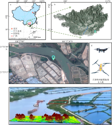
图1
研究区概况图 a. 中国地图及北部湾经济区的位置, 本图基于自然资源部标准地图服务网站下载的审图号为GS(2019)1822号的标准地图制作; b. 研究区位于广西的相对位置; c. 研究区2023年10月高分二号影像; d. 激光点云数据采集的无人机型号; e. 无人机激光点云数据拍摄处(左)和研究区的航拍摄影和经处理后的激光点云数据示例图"

图1
表S1
选用的植被指数"
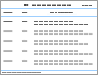
| 植被指数名称 | 英文名称 | 简称 | 公式 | 特点 | 参考文献 |
|---|---|---|---|---|---|
| 归一化差异 植被指数 | normalized difference vegetation index | NDVI | (RNIR−Rred)/( RNIR + Rred) | 突出观测植被的特殊光谱特征, 已经被广泛应用。可用于监测植被生长状况。该指数也可用于地表分类、区分不同的树种等领域 | Rouse et al, |
| 增强型 植被指数 | enhanced vegetation index | EVI | 2.5(RNIR − Rred) | EVI是一种优化后的植被指数, 通过对植被冠层信号的解耦, 提高了高生物量区域的反演效果的同时又能纠正土壤背景和气溶胶散射的影响。 | Huete et al, |
| 过绿指数 | excess green index | EXG | 2 Rgreen − Rred - Rblue | 这是一种泛用的监测小范围植物的植被指数 | Woebbecke et al, |
| 绿色归一化 植被指数 | normalized green difference vegetation index | GNDVI | (RNIR − Rgreen)/( RNIR + Rgreen) | 这是一种改良的NDVI指数, 与氮的相关性良好。对正在拔节、抽雄时期的植被反应精度较高 | Daughtry et al, |
| 湿度植被指数 | moisture vegetation index | MVI | (RNIR − Rred)/( RNIR + Rred) + 0.5 | 湿度植被指数不仅可以反应植被的冠层结构, 还能反应叶片属性 | 金一谔 等, |
| 归一化差异 绿度指数 | normalized difference green degree index | NDGI | (Rgreen − Rred)/( Rgreen + Rred) | 主要反应植被的光能转化 | Lyon et al, |
| 归一化 色素比值指数 | normalized pigment chlorophyll index | NPCI | (Rred − Rblue)/( Rred + Rblue) | 一种用来反应叶绿素的植被指数, 多用于植被的生长检测 | Clay et al, |
| 红色植被指数 | redness index | RI | (Rred − Rgreen)/( Rred + Rgreen) | 校正了土壤颜色对植被指数的影响 | Huete et al, |
| 结构 不敏感指数 | structure independent pigment index | SIPI | (RNIR − Rblue)/( RNIR + Rblue) | 该指数的内在逻辑为, 当植被叶面积指数降低时, 类胡萝卜指数(一种对叶绿素比率敏感的指数)和冠层应力增加 | Penuelas et al, |
| 转换植被指数 | triangle vegetation index | TVI | 60(RNIR − Rgreen)−100(Rred − Rgreen) | 该指数多用以反应植物吸收的辐射能量与红、绿、近红外波段的反射率关系, 是很好的反应生物量的指数 | Broge et al, |
表S1
表S2
提取的纹理指数"
| 纹理特征参数名称 | 公式 | 参考文献 |
|---|---|---|
| 均值(mean) | $\sum_{i, j=0}^{N-1} i P_{i, j}$ | Kadiyala et al, |
| 方差(variance) | $\sum_{i, j=0}^{N-1} P_{i, j}\left(1-\mu_{i}\right)$ | Kadiyala et al, |
| 同质性(homogeneity) | $\sum_{i, j=0}^{N-1} \frac{i P_{i, j}}{1+(1-j)^{2}}$ | |
| 对比度(contrast) | $\sum_{i, j=0}^{N-1} i P_{i, j}(i-j)$ | Kadiyala et al, |
| 异质性(dissimilarity) | $\sum_{i, j=0}^{N-1} i P_{i, j}|i-j|$ | |
| 熵(entropy) | $\sum_{i, j=0}^{N-1} P_{i, j}\left(-\ln P_{i, j}\right)$ | |
| 角二阶矩(angular second moment) | $\sum_{i, j=0}^{N-1}\left(i P_{i, j}\right)^{2}$ | |
| 相关性(correlation) | $\sum_{i, j=0}^{N-1} \frac{i j P_{i, j}-\mu_{i} \mu_{i j}}{\sigma_{i}^{2} \sigma_{j}^{2}}$ |
表S2
表S3
激光点云参数"
| 参数名称 | 说明 | 参考文献 |
|---|---|---|
| 间隙率(gap fraction) | 间隙率(P)是指在特定天顶角θ方向上, 激光脉冲能够穿透植被冠层到达地面的概率 | Shamaoma et al, |
| 叶面积指数(LAI) | $\text{LAI}=-\ln \left( P \right)\times k$ 其中, P是间隙率, k是消光系数, 通常需要根据植被类型和激光入射角进行校准 | |
| 覆盖度(coverage) | 覆盖度通常指植被冠层覆盖地面的比例。在LiDAR中, 可以通过计算冠层点云投影到地面的面积与总地面面积的比例来估算 | |
| 强度百分位(intensity percentiles) | 强度百分位是激光回波强度值的百分位数统计量。本文选用了第90百分位的强度值 |
表S3
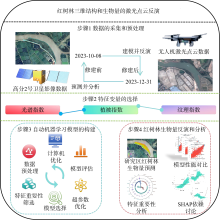
图2
技术流程图"
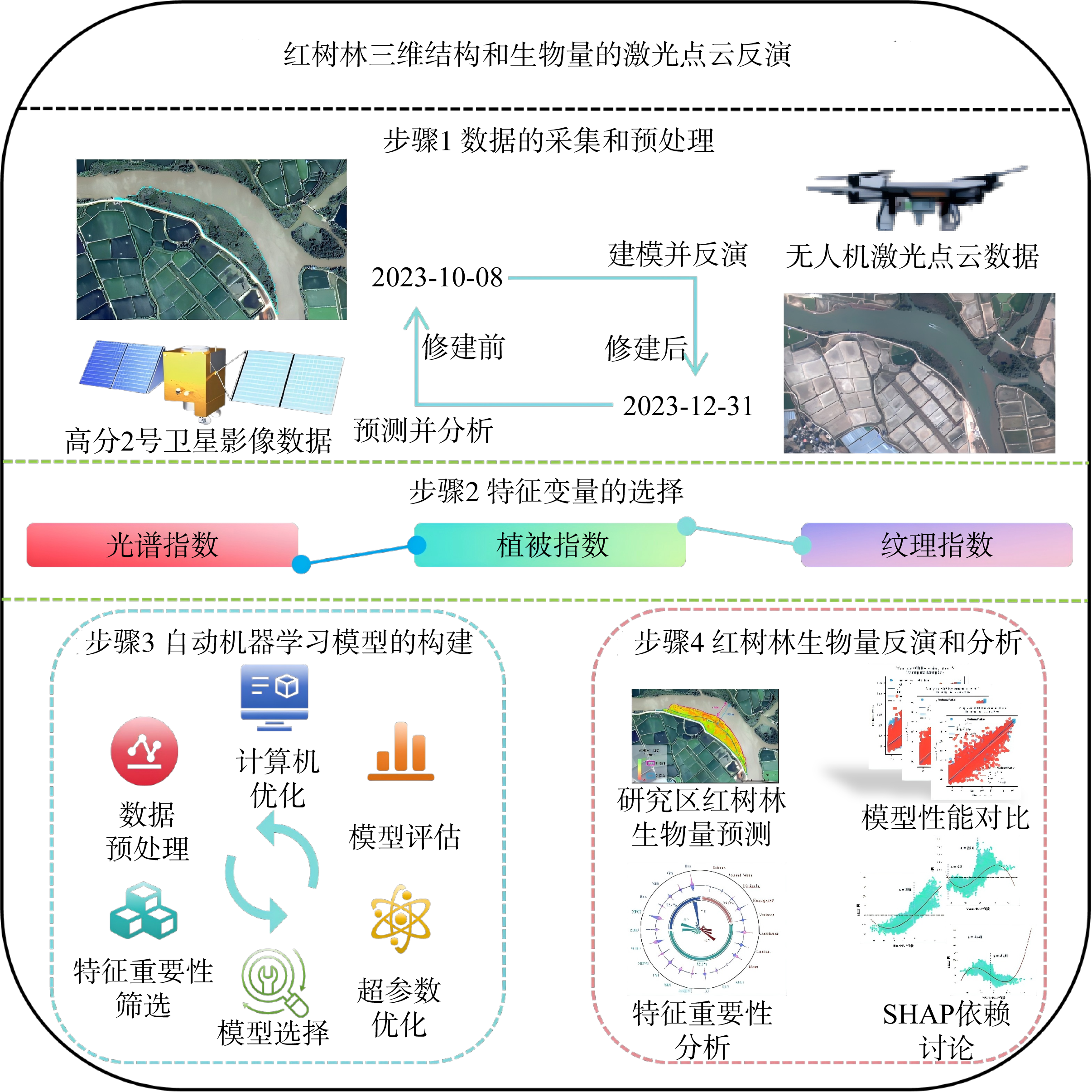
图2
表1
各特征变量对反演精度的贡献作用"
| 使用的特征变量 | 最佳模型 | 训练集精度 | 训练集标准差/(t·hm−2) | 测试集精度 | 测试集标准差/(t·hm−2) |
|---|---|---|---|---|---|
| 仅用影像原始波段 | LGBM | 0.63 | 17.20 | 0.58 | 18.67 |
| 影像波段+植被指数 | LGBM | 0.95 | 5.82 | 0.81 | 12.07 |
| 影像波段+植被指数+纹理指数 | LGBM | 0.98 | 4.36 | 0.84 | 11.32 |
| 影像波段+植被指数+纹理指数+激光点云参数 | LGBM | 0.98 | 3.39 | 0.85 | 11.20 |
表1
表2
红树林地上生物量预测中的各模型性能"
| 模型 | 训练集精度 | 训练集标准差/(t·hm−2) | 测试集精度 | 测试集标准差/(t·hm−2) |
|---|---|---|---|---|
| LGBM | 0.98 | 3.39 | 0.85 | 11.20 |
| RF | 0.97 | 4.52 | 0.82 | 12.80 |
| XGBoost | 0.98 | 3.49 | 0.84 | 11.49 |
| CatBoost | 0.92 | 7.96 | 0.83 | 11.89 |
| XGB_limitdepth | 0.99 | 2.73 | 0.83 | 11.77 |
| KNeighbor | 1 | 0 | 0.42 | 21.73 |
表2
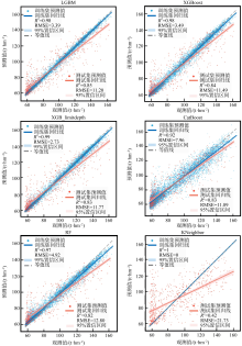
图3
FLAML框架下各模型预测性能对比"

图3
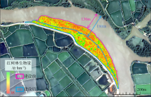
图4
研究区红树林生物量预测结果图"

图4
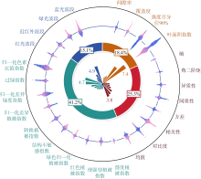
图5
各特征变量SHAP分析图"

图5
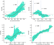
图6
四类特征变量中的最佳变量的SHAP依赖图"

图6
表3
运行时长(迭代次数)对模型的影响"
| 运行时间 | 迭代次数 | 训练集精度 | 训练集标准差/(t·hm−2) | 测试集精度 | 测试集标准差(/t·hm−2) |
|---|---|---|---|---|---|
| 10s | 10 | 0.77 | 13.69 | 0.68 | 15.69 |
| 20s | 14 | 0.88 | 9.71 | 0.77 | 13.31 |
| 30s | 17 | 0.91 | 8.30 | 0.80 | 12.60 |
| 45s | 19 | 0.98 | 3.39 | 0.85 | 11.20 |
| 60s | 21 | 0.98 | 3.39 | 0.85 | 11.20 |
表3
| [1] |
敖登, 杨佳慧, 丁维婷, 等, 2023. 54种植被指数研究进展综述[J]. 安徽农业科学, 51(1): 13-21+28.
|
|
|
|
| [2] |
金一谔, 刘长盛, 张文忠, 1998. 利用气象卫星GMS和AVHRR资料推算地面水分含量的方法[J]. 应用气象学报, 9(2): 197-204.
|
|
|
|
| [3] |
doi: 10.1017/S0376892902000231 |
| [4] |
doi: 10.1146/annurev-marine-010213-135020 pmid: 24405426 |
| [5] |
doi: 10.3390/f13101545 |
| [6] |
doi: 10.1016/j.biortech.2023.129436 |
| [7] |
doi: 10.1890/1540-9295(2006)004[0124:NBTNDR]2.0.CO;2 |
| [8] |
doi: 10.1016/S0034-4257(00)00197-8 |
| [9] |
doi: 10.1126/science.223.4642.1290 pmid: 17759366 |
| [10] |
doi: 10.1007/s11705-024-2487-0 |
| [11] |
|
| [12] |
doi: 10.2134/agronj2005.0204 |
| [13] |
doi: 10.1016/j.ppees.2007.11.001 |
| [14] |
doi: 10.1016/0034-4257(92)90132-4 |
| [15] |
doi: 10.1016/j.scitotenv.2022.154707 |
| [16] |
doi: 10.1080/01431161.2012.712224 |
| [17] |
doi: 10.1080/01431161.2017.1285083 |
| [18] |
|
| [19] |
doi: 10.1016/j.ecss.2017.11.004 |
| [20] |
doi: 10.1016/S0034-4257(02)00096-2 |
| [21] |
doi: 10.1016/0034-4257(91)90008-T |
| [22] |
doi: 10.1016/j.apgeog.2013.09.024 |
| [23] |
|
| [24] |
doi: 10.3390/rs3050878 |
| [25] |
|
| [26] |
doi: 10.3390/su17188211 |
| [27] |
doi: 10.1890/110004 |
| [28] |
doi: 10.1186/s13021-021-00172-9 pmid: 33730236 |
| [29] |
doi: 10.7717/peerj-cs.2188 pmid: 39145237 |
| [30] |
doi: 10.1038/nclimate2734 |
| [31] |
doi: 10.1007/s00468-015-1334-9 |
| [32] |
|
| [33] |
doi: 10.1016/j.jag.2024.103769 |
| [34] |
doi: 10.1117/1.JRS.11.026010 |
| [35] |
doi: 10.1080/01431161.2018.1471544 |
| [36] |
doi: 10.3390/rs11030230 |
| [37] |
doi: 10.1016/j.rse.2020.112165 |
| [38] |
doi: 10.1016/j.rsase.2022.100725 |
| [39] |
doi: 10.1088/1748-9326/ac31ee |
| [40] |
|
| [41] |
|
| [42] |
doi: 10.1016/j.ecss.2020.106585 |
| [43] |
doi: 10.1186/s13007-024-01212-4 pmid: 38849856 |
| [44] |
|
| [45] |
doi: 10.3390/su10020472 |
| [46] |
doi: 10.1016/j.scitotenv.2021.146816 |
| [47] |
doi: 10.3390/rs14194868 |
| [48] |
|
| [49] |
doi: 10.3390/computers10010011 |
| [50] |
doi: 10.1038/s41597-025-04881-5 |
| [51] |
doi: 10.1109/Access.6287639 |
| [52] |
doi: 10.1080/01431161.2015.1117679 |
| [53] |
doi: 10.13031/2013.27838 |
| [54] |
|
| [55] |
|
| [1] | 梁喜幸, 戴志军, 李焰, 黎树式, 李为华, 王日明, 吴尔江. 基于Sentinel-2的平陆运河出海口红树林动态变化特征[J]. 热带海洋学报, 2026, 45(4): 77-88. |
| [2] | 齐峰, 邓晓杰, 关永鹏, 周盛垚, 何庆, RAJAPAKSHALAGE Thashikala Nethmini, 李楠, 姜宫凌侠, 陈清香, 雷欣悦, 侯庆华, 黄来珍, 李小蕾, 韦巧艳. 红树植物秋茄根系固氮微生物群落的稳定性和复杂性及其关键影响因子研究[J]. 热带海洋学报, 2026, 45(3): 153-163. |
| [3] | 谭清碧, 郭泓瀛, 孙思旗, 钟宇航, 聂会, 牛丽霞. 稳定同位素示踪浙江清江口红树林沉积物氮源及其影响因子分析[J]. 热带海洋学报, 2026, 45(3): 202-211. |
| [4] | 方扬, 唐俊逸, 罗育池, 叶匡旻, 邓炜华. 外来红树引入对生态系统健康与服务功能的影响——以广东省3个典型区域为例[J]. 热带海洋学报, 2026, 45(2): 173-190. |
| [5] | 蒋守殿, 胡鑫, 蓝珮心, 姚李勤, 水柏年, 纪建达, 何茂求. 浙江西门岛红树林细菌群落季节性特征及环境驱动因素[J]. 热带海洋学报, 2026, 45(2): 117-128. |
| [6] | 粟春青, 高育慧, 罗炘武, 韩梦梦, 宫彦章, 郑卫国. 深圳不同红树林群落生物量和碳储量[J]. 热带海洋学报, 2025, 44(6): 155-164. |
| [7] | 王日明, 苏金恒, 戴志军, 吴天亮, 谢晓雯, 黄春梅, 李兴荣, 张尚宇. 钦州湾茅岭江河口红树林湿地动态变化过程[J]. 热带海洋学报, 2025, 44(6): 143-154. |
| [8] | 谢小魁, 李兴荣, 王日明, 戴志军, 龚受基, 庞文鸿, 张尚宇. 北部湾茅尾海潮滩外来红树无瓣海桑时空演替[J]. 热带海洋学报, 2025, 44(6): 132-142. |
| [9] | 胡鑫, 熊兰兰, 陈顺洋, 张黄琛, 邹易阳, 张吉超, 刘东熙, 何佳潞, 吴于琪, 朱振杰. 幼龄红树生物量模型及幼林红树林碳储量研究*[J]. 热带海洋学报, 2025, 44(4): 187-199. |
| [10] | 田蜜, 钟才荣, 吕晓波, 方赞山, 黄丹慜. 东寨港不同退塘还林模式红树林群落特征比较[J]. 热带海洋学报, 2025, 44(3): 58-65. |
| [11] | 袁羽杰, 钟仕全, 蒋卫国, 初爱萍, 凌子燕. 基于环境减灾二号卫星的2023年铁山港红树林病虫害动态监测[J]. 热带海洋学报, 2025, 44(3): 188-196. |
| [12] | 刘思妮, 白猛, 朱义广, 罗小卫, 高程海, 刘永宏, 徐新亚, 蒋晓东. 红树林来源链霉菌中2-羟基苯基噻唑啉衍生物及其生物合成基因簇分析[J]. 热带海洋学报, 2025, 44(2): 64-72. |
| [13] | 吴雪, 赵鑫, 辜伟芳, 朱科桦, 葛振鸣. 浙南海岸带人工秋茄(Kandelia obovata)红树林与互花米草(Spartina alterniflora)盐沼土壤碳汇对比研究[J]. 热带海洋学报, 2025, 44(1): 172-181. |
| [14] | 黄良民, 林强, 谭烨辉, 黄小平, 周林滨, 黄晖. 热带海洋特色生态系统恢复重构与保护思考*[J]. 热带海洋学报, 2024, 43(6): 1-12. |
| [15] | 吴鸿博, 罗锋, 陈治澎, 朱飞, 曾靖伟, 张弛, 李瑞杰. 红树林生态重建效果预测研究新模式[J]. 热带海洋学报, 2024, 43(4): 86-97. |
|
||