
Journal of Tropical Oceanography ›› 2023, Vol. 42 ›› Issue (2): 124-131.doi: 10.11978/2022087CSTR: 32234.14.2022087
• Marine geomorphology • Previous Articles Next Articles
Impact of the coastal reclamations on topography evolution in the Qinzhou Bay, Guangxi
ZHANG Min1,2( ), WU Hangxing2, LU Yibin2, LU Diwen2, MI Jie2, ZHU Donglin1, CHEN Bo1
- 1. Guangxi Key Laboratory of Marine Environmental Science, Guangxi Beibu Gulf Marine Research Center, Guangxi Academy of Sciences, Nanning 530007, China
2. School of Environmental and Geographical Sciences, Shanghai Normal University, Shanghai 200234, China
-
Received:2022-04-21Revised:2022-07-22Online:2023-03-10Published:2022-08-15 -
Contact:ZHANG Min. email:zhangmin@shnu.edu.cn -
Supported by:Guangxi Key Laboratory of Marine Environmental Science, Guangxi Academy of Sciences(GXKLHY21-02); National Natural Science Foundation of China(42171282); National Natural Science Foundation of China(41930537); Shanghai Pujiang Program(21PJC096)
Cite this article
ZHANG Min, WU Hangxing, LU Yibin, LU Diwen, MI Jie, ZHU Donglin, CHEN Bo. Impact of the coastal reclamations on topography evolution in the Qinzhou Bay, Guangxi[J].Journal of Tropical Oceanography, 2023, 42(2): 124-131.
share this article
Add to citation manager EndNote|Reference Manager|ProCite|BibTeX|RefWorks
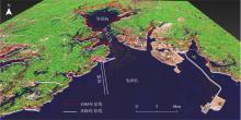
Fig. 1
Landform of the study area and the historical shoreline reclamations (remote sensing stereo-mapping)"
Fig. 1
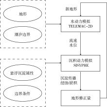
Fig. 2
Coupled hydro-morpho-dynamics model calculating process"
Fig. 2
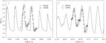
Fig. 3
Comparison of simulated and measured water level. (a) Typhoon Kai-Tak; (b) Typhoon Son-Tinh"

Fig. 3
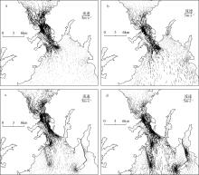
Fig. 4
Comparison of flow field before and after reclamation: the spatial distribution during flood maximum and ebb maximum"

Fig. 4
Tab. 1
The historical shoreline length and the reclamation area in the core area of the Qinzhou Bay in 1985 and 2020"
| 时间 | 岸线长度/km | 时间 | 地点 | 围垦面积/km2 |
|---|---|---|---|---|
| 1985年 | 425 | 1992年 | 钦州港港区 | 10.09 |
| 2020年 | 525 | 2008年 | 保税港区 | 26.15 |
| 2009年 | 三墩公路 | 3.18 |
Tab. 1

Fig. 5
Comparison of tidal asymmetries before and after reclamation. (a) 1985; (b) 2020; (c) difference between 2020 and 1985"
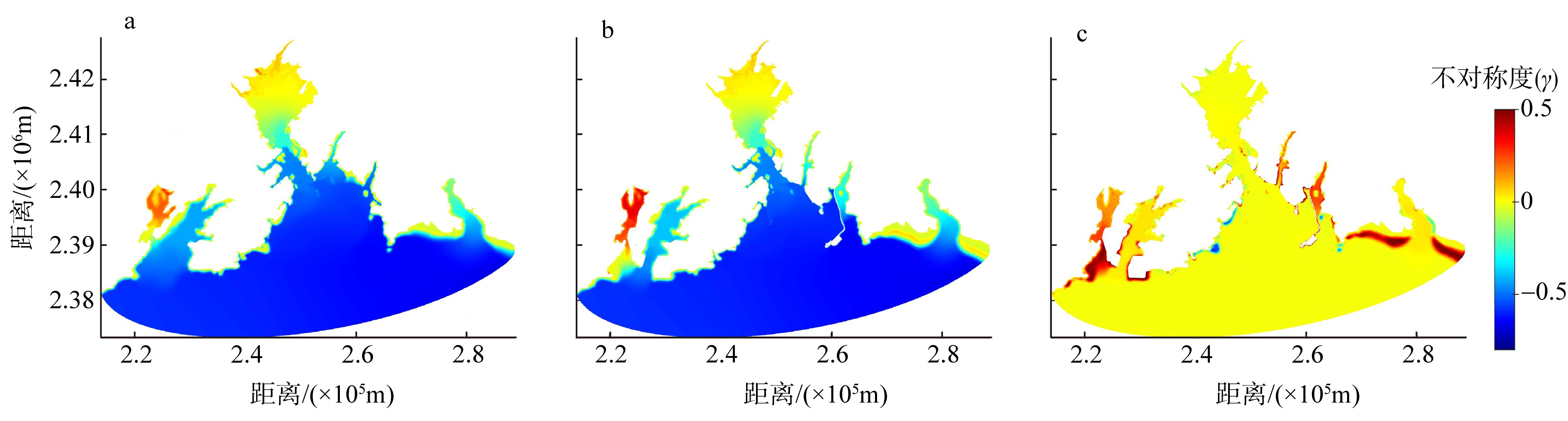
Fig. 5
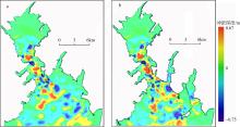
Fig. 6
Projections of underwater geomorphology evolution over the next 30 years. (a) based on 1985 bathymetry; (b) based on 2020 bathymetry"

Fig. 6
| [1] |
曹超, 吴承强, 蔡锋, 等, 2020. 钦州湾外湾水下地形地貌特征及沉积物来源[J]. 应用海洋学学报, 39(3): 378-388.
|
|
|
|
| [2] |
陈波, 侍茂崇, 邱绍芳, 2003. 广西主要港湾余流特征及其对物质输运的影响[J]. 海洋湖沼通报, (1): 13-21.
|
|
|
|
| [3] |
董德信, 李谊纯, 陈宪云, 等, 2014. 钦州湾潮流季节变化特征[J]. 广西科学, 21(4): 351-356.
|
|
|
|
| [4] |
李莎莎, 孟宪伟, 葛振鸣, 等, 2014. 海平面上升影响下广西钦州湾红树林脆弱性评价[J]. 生态学报, 34(10): 2702-2711.
|
|
|
|
| [5] |
李逸聪, 王义刚, 黄惠明, 2017. 湾口围填海对钦州湾水动力环境的影响[J]. 水运工程, (3): 44-50.
|
|
|
|
| [6] |
吕赫, 张少峰, 宋德海, 等, 2021. 围填海累积效应对钦州湾水动力环境的影响[J]. 海洋与湖沼, 52(4): 823-833.
|
|
|
|
| [7] |
莫永杰, 1993. 钦州湾溺谷湾地貌、沉积与物质运移[J]. 海洋通报, (5): 56-61.
|
|
|
|
| [8] |
孙永根, 高俊国, 朱晓明, 2012. 钦州保税港区填海造地工程对海洋环境的影响[J]. 海洋科学, 36(12): 84-89.
|
|
|
|
| [9] |
夏长水, 陈振华, 韦重霄, 等, 2020. 广西钦州茅尾海综合整治水动力影响研究[J]. 海岸工程, 39(3): 157-168.
|
|
|
|
| [10] |
牙韩争, 许尤厚, 李谊纯, 等, 2017. 岸线变化对钦州湾水动力环境的影响[J]. 广西科学, 24(3): 311-315.
|
|
|
|
| [11] |
阎新兴, 刘国亭, 2006. 钦州湾近海区沉积特征及航道淤积研究[J]. 水道港口, (2): 79-83.
|
|
|
|
| [12] |
杨莉玲, 王琳, 杨芳, 等, 2019. 口外岸线变化对茅尾海潮流动力及水体交换的影响[J]. 海洋环境科学, 38(4): 582-588.
|
|
|
|
| [13] |
杨留柱, 杨莉玲, 潘洪州, 等, 2019. 人类活动影响下的钦州湾近期滩槽冲淤演变特征[J]. 热带海洋学报, 38(6): 41-50.
doi: 10.11978/2019013 |
|
doi: 10.11978/2019013 |
|
| [14] |
张伯虎, 2010. 广西重点港湾沉积动力特征及其冲淤演变[D]. 华东师范大学.
|
|
|
|
| [15] |
张敏, 米婕, 戴志军, 等, 2021. 海平面上升对北部湾风暴潮增水影响研究——以2012年台风“山神”为例[J]. 海洋通报, 40(3): 309-318.
|
|
|
|
| [16] |
doi: 10.1016/j.coastaleng.2013.08.005 |
| [17] |
doi: 10.1002/(ISSN)1099-1085 |
| [18] |
doi: 10.1016/j.scitotenv.2022.154813 |
| [19] |
doi: 10.1016/j.ecss.2013.08.023 |
| [20] |
doi: 10.1016/j.margeo.2017.02.013 |
| [21] |
doi: 10.1016/j.rsma.2021.101710 |
| [22] |
doi: 10.1016/j.advwatres.2020.103660 |
| [1] | WANG Xu, QU Ke, WANG Zijun, YANG Yuanping, WANG Chao, ZHANG Liangbin. Numerical simulation study on the effect of wind on the hydrodynamic characteristics of undular tidal bores seawall [J]. Journal of Tropical Oceanography, 2024, 43(5): 116-130. |
| [2] | WU Hongbo, LUO Feng, CHEN Zhipeng, ZHU Fei, ZENG Jingwei, ZHANG Chi, LI Ruijie. A novel pattern for predicting the effects of mangrove ecological reconstruction [J]. Journal of Tropical Oceanography, 2024, 43(4): 86-97. |
| [3] | ZHANG Zheran, HU Junyang, ZHOU Kai, ZHANG Penghui, XING Jiuxing, CHEN Shengli. Storm surge simulations of the coastal area of Shenzhen using different types of typhoon meteorological fields—a case study of Typhoon Mangkhut* [J]. Journal of Tropical Oceanography, 2023, 42(6): 1-14. |
| [4] | GU Jinghua, ZHU Jianrong, JIN Zhi. Numerical simulation of oil film drift and diffusion after oil spill accident at the Baosteel wharf in the Changjiang Estuary [J]. Journal of Tropical Oceanography, 2022, 41(6): 159-170. |
| [5] | WANG Renzheng, SHAN Zhengduo, MENG Siyu, GONG Xiang. Interannual variation of subsurface chlorophyll maximum in the northern South China Sea [J]. Journal of Tropical Oceanography, 2021, 40(6): 63-75. |
| [6] | DAI Zhijun, ZHOU Xiaoyan, WANG Jie, HU Baoqing. Review and prospect of mangrove tidal flat sedimentary dynamics [J]. Journal of Tropical Oceanography, 2021, 40(3): 69-75. |
| [7] | ZHANG Hua, WEN Xixi, PENG Shiqiu. Numerical simulation of barotropic tides in Mozambique Strait and its adjacent coastal area and energy budget analysis* [J]. Journal of Tropical Oceanography, 2021, 40(2): 7-16. |
| [8] | Juan Li, Junliang Liu, Shuqun Cai. Numerical simulation of oceanic near-inertial energy induced by Typhoon Conson [J]. Journal of Tropical Oceanography, 2020, 39(2): 35-43. |
| [9] | Yan XU, Xiangquan LIU, Rengang SONG, Xianrong CEN, Shuangxi GUO, Shengqi ZHOU. Numerical simulation of diffusive convection staircase [J]. Journal of Tropical Oceanography, 2019, 38(1): 11-18. |
| [10] | Wen WU, Yuhan YAN, Dehai SONG. Study on the tidal dynamics in Daya Bay, China — Part I. Observation and numerical simulation of tidal dynamic system [J]. Journal of Tropical Oceanography, 2017, 36(3): 34-45. |
| [11] | Yuhan YAN, Wen WU, Dehai SONG, Xianwen BAO. Study on the tidal dynamics in Daya Bay, China — Part Ⅱ. The generation of double high waters and double-peak flood-current flows [J]. Journal of Tropical Oceanography, 2017, 36(3): 46-54. |
| [12] | YE Feng, BAO Yun. Study of hydrothermal plume transport range in a stratified background [J]. Journal of Tropical Oceanography, 2016, 35(5): 97-102. |
| [13] | LIU Zufa, GUAN Shuai, ZHANG Ganhao, DING Bo, LIN Yingyan, ZHA Xini. Three-dimensional numerical simulation of saltwater intrusion into the Humen estuary based on FVCOM [J]. Journal of Tropical Oceanography, 2016, 35(2): 10-18. |
| [14] | FANG Zhou, YAN Sheng-fu, WANG Xu. Comparative study of three wave-generating methods for internal solitary waves in a two-layer fluid [J]. Journal of Tropical Oceanography, 2015, 34(4): 31-36. |
| [15] | YAN Tong, QI Yi-quan, JING Zhi-you. A numerical study on the responses of the South China Sea upper circulation to different climatological wind products [J]. Journal of Tropical Oceanography, 2015, 34(4): 1-11. |
|
||