
Journal of Tropical Oceanography ›› 2026, Vol. 45 ›› Issue (3): 10-24.doi: 10.11978/2025073CSTR: 32234.14.2025073
Special Issue: 南海专题
Previous Articles Next Articles
Study on the geological structural characteristics of the U-shaped boundary in the South China Sea
ZHANG Yunfan1( ), TANG Danling2(), SUN Zhen1(), QIU Ning3
- 1
Laboratory of Ocean and Marginal Sea Geology ,South China Sea Institute of Oceanology, Chinese Academy of Sciences
2Southern Marine Science and Engineering Guangdong Laboratory (Guangzhou)
3State Key Laboratory of Tropical Oceanography ,South China Sea Institute of Oceanology, Chinese Academy of Sciences
-
Received:2025-06-04Revised:2025-10-10Online:2026-05-10Published:2026-05-28 -
Contact:SUN Zhen. email: sun_zhen2024@126.com; TANG Danling. email: lingzistdl@126.com -
Supported by:Guangdong Special Support Talent Team Program(2019BT02H594); PI Project of Southern Marine Science and Engineering Guangdong Laboratory (Guangzhou)(GML2021GD0810)
CLC Number:
- P736
Cite this article
ZHANG Yunfan, TANG Danling, SUN Zhen, QIU Ning. Study on the geological structural characteristics of the U-shaped boundary in the South China Sea[J].Journal of Tropical Oceanography, 2026, 45(3): 10-24.
share this article
Add to citation manager EndNote|Reference Manager|ProCite|BibTeX|RefWorks
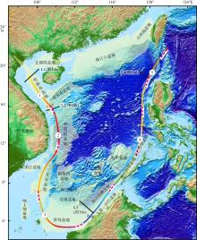
Fig. 1
U-shaped boundary in the South China Sea and regional tectonic-geological map of the South China Sea. The color belt represents the U-shaped boundary, while the light yellow areas denote the peripheral basins of the South China Sea. The numbers indicate five sectional intervals of the U-shaped boundary: 1 for the U-NW section, 2 for the U-W section, 3 for the U-S section, 4 for the U-E section, and 5 for the U-NE section. The red dashed line depicts the nine-dash line, drawn based on the topographic map of the South China Sea (Luo, 2023)"

Fig. 1
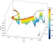
Fig. 2
Three-dimensional depth map of the U-shaped boundary in the South China Sea"

Fig. 2
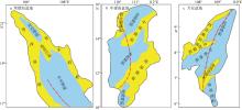
Fig. 3
Map of the U-shaped boundary in the South China Sea and the structural geological units of the Yinggehai Basin, Zhongjiannan Basin, and Wan’an Basin. The red dash-dotted lines are the U-shaped boundary, the blue areas represent depressions, and the yellow areas represent uplifts. Modified from Xu (2018), Wang et al (2022), and Xiao et al (2021)"

Fig. 3
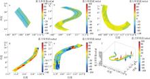
Fig. 4
Gravity anomaly of five sections in the U-shaped boundary. (a) Gravity anomaly of the U-NW section; (b) gravity anomaly of the U-W section; (c) gravity anomaly of the U-S section; (d) gravity anomaly of the U-E section; (e) gravity anomaly of the U-NE section; (f) 3D view of the U-shaped boundary gravity anomaly"

Fig. 4
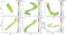
Fig. 5
Magnetic anomaly of five sections in the U-shaped boundary. (a) Magnetic anomaly of the U-NW section; (b) magnetic anomaly of the U-W section; (c) magnetic anomaly of the U-S section; (d) magnetic anomaly of the U-E section; (e) magnetic anomaly of the U-NE section; (f) 3D view of the U-shaped boundary magnetic anomaly"
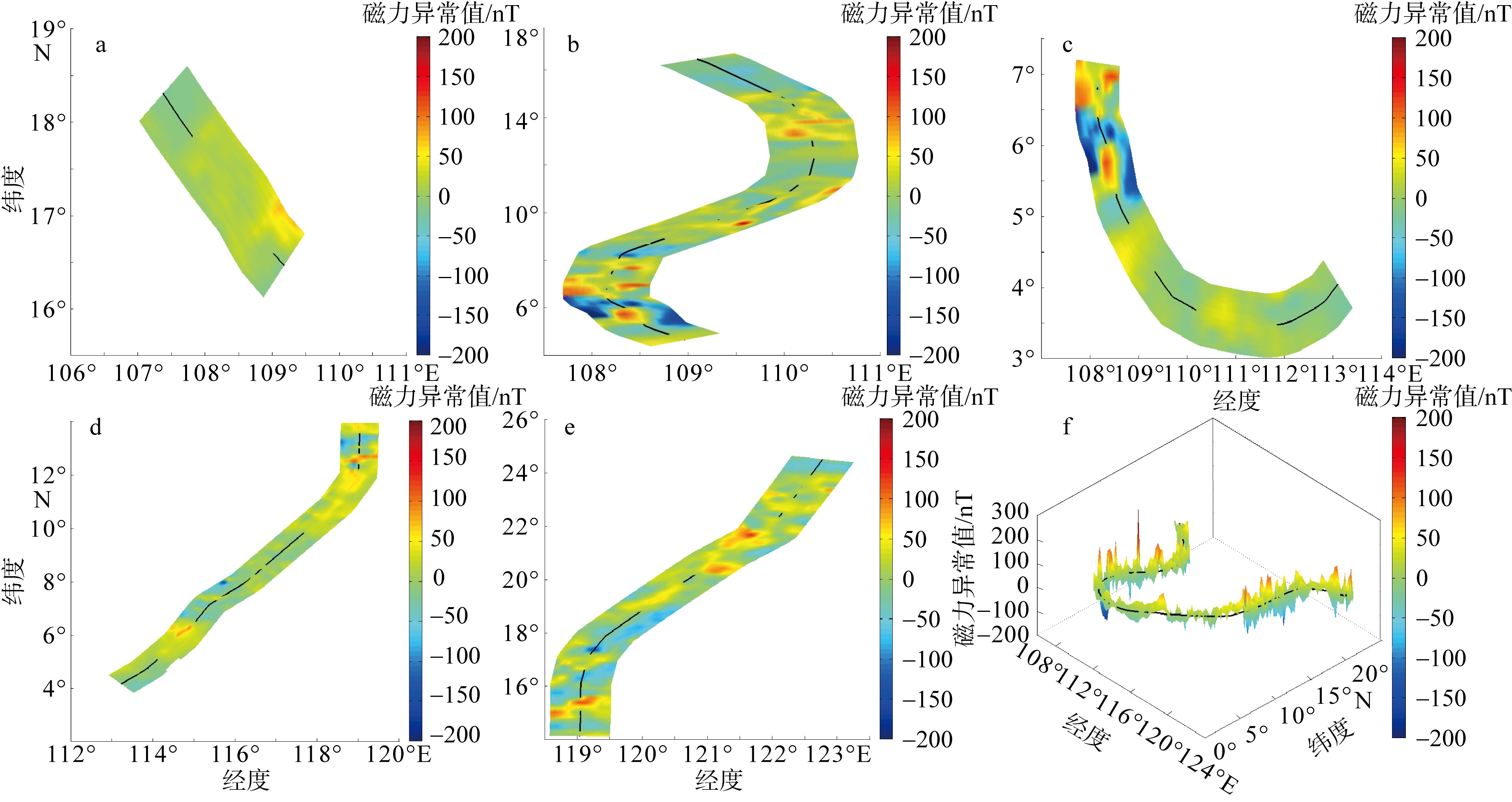
Fig. 5
Fig. 6
Planar structural characteristics of the U-NW section of the U-shaped boundary in the South China Sea. The red dotted line represents the U-shaped boundary, the black lines denote faults, and the blue dots indicate diapiric structures, as identified by Lei et al (2015)"
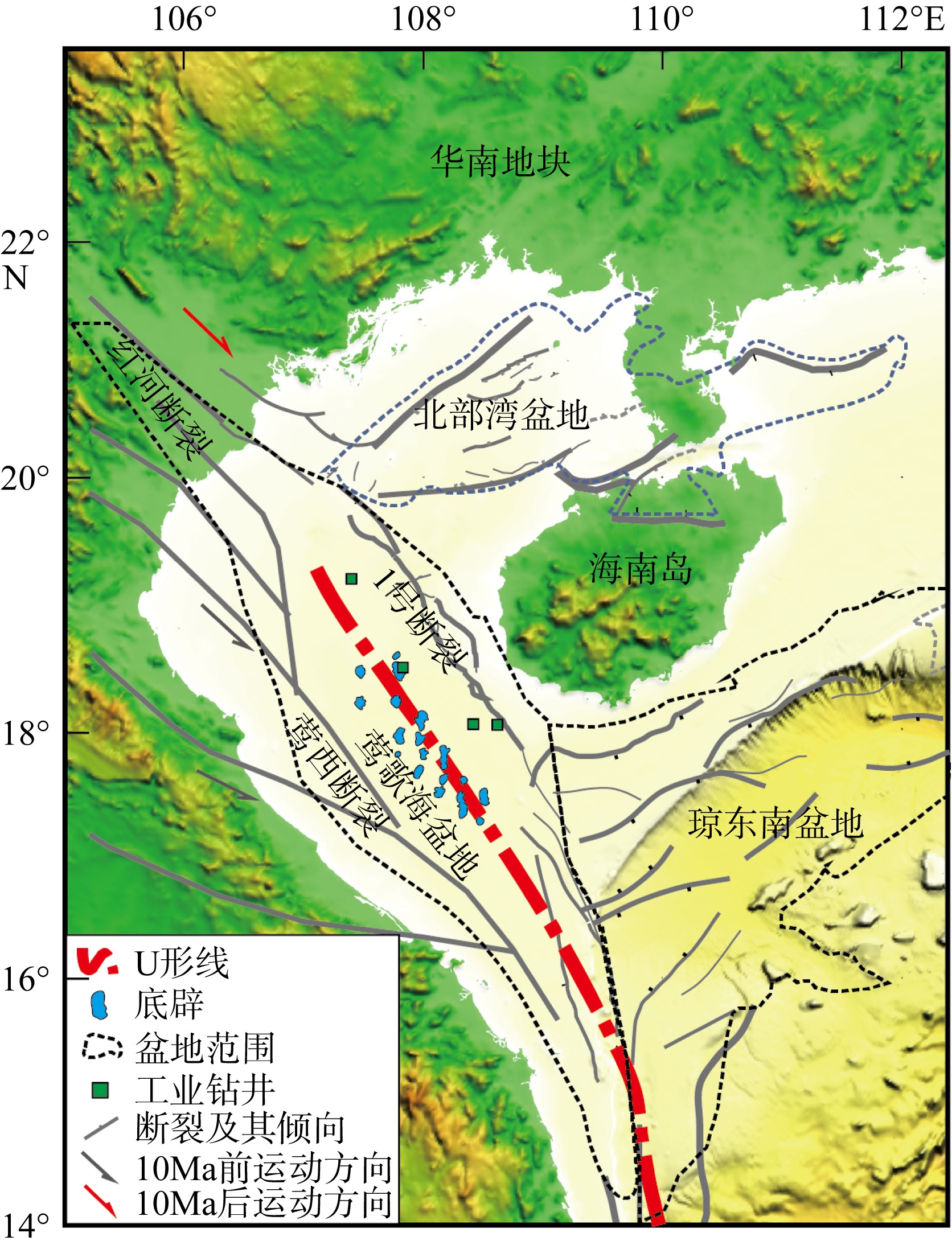
Fig. 6
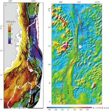
Fig. 7
Direction and structural characteristics of the U-W section and Western Margin Fault, South China Sea. (a) Distribution of the fault; (b) gravity anomaly of the fault. Adapted from Fyhn et al (2009), with numeral 2 indicating the U-W section of the U-shaped boundary"

Fig. 7
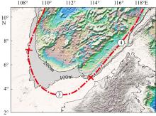
Fig. 8
Shapes of the U-S and U-E sections of the U-shaped boundary and shelf breaks in the southern South China Sea. The grey shade is the area with water depths from 100 to 200 meters. Numerals 3 and 4 are the U-S section and the U-E section of the U-shaped boundary, respectively"
Fig. 8
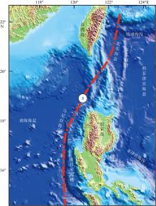
Fig. 9
Tectonic-geological map of Manila Trench and the U-NE section of the U-shaped boundary"

Fig. 9
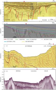
Fig. 10
Seismic profiles perpendicular to the U-shaped boundary. The position of the survey line is shown in Fig. 1. The red star represents the U-shaped boundary location. L1 is the seismic profile of the Yinggehai Basin of the U1 section (adapted from Sun et al, 2003; Lei et al, 2015). L2 is the seismic profile of the negative flower-shaped structure of the Western Margin Fault, with the white frame indicating the negative flower-shaped structures (adapted from Vu et al, 2017); L3 is the seismic profile of the Nansha Block (adapted from Yao et al, 2023); L4 is the seismic profile of Manila Trench in the U5 section (adapted from Chang et al, 2012)"

Fig. 10
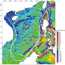
Fig. 11
Gravity anomaly of South China Sea. The white line is the U-shaped boundary"

Fig. 11
| [1] |
龚再升, 李思田, 谢泰俊, 等, 1997. 南海北部大陆边缘盆地分析与油气聚集[M]. 北京: 科学出版社: 12-16.
|
|
|
|
| [2] |
郭令智, 钟志洪, 王良书, 等, 2001. 莺歌海盆地周边区域构造演化[J]. 高校地质学报, 7(1): 1-12.
|
|
|
|
| [3] |
高红芳, 2011. 南海西缘断裂带走滑特征及其形成机理初步研究[J]. 中国地质, 38(3): 537-543.
|
|
|
|
| [4] |
罗伟东, 胡小三, 周娇, 等, 2023. 南海及邻域海底地形地貌[M], 北京: 科学出版社: 12-16.
|
|
|
|
| [5] |
李春峰, 林间, 2014. 南海第二次国际大洋钻探获得完整深海岩芯记录[J]. 科学通报, 59(12): 1164 (in Chinese).
|
| [6] |
李家彪, 丁巍伟, 高金耀, 等, 2011. 南海新生代海底扩张的构造演化模式: 来自高分辨率地球物理数据的新认识[J]. 地球物理学报, 54(12): 3004-3015.
|
|
|
|
| [7] |
李敬敏, 张文志, 刘诗华, 等, 2022. 南海U形海疆线及南海诸岛部分地名数据集研究[J]. 全球变化数据学报(中英文), 6(1): 118-124.
|
|
|
|
| [8] |
林长松, 唐勇, 谭勇华, 2009. 南海西缘断裂带右行走滑的地球动力学机制[J]. 海洋学报, 31(1): 159-167.
|
|
|
|
| [9] |
刘宇鹏, 唐丹玲, 吴常霞, 等, 2019. 南海U形海疆线的生态环境分区特征[J]. 海洋学报, 41(2): 14-30.
|
|
|
|
| [10] |
骆遥, 李敬敏, 张文志, 等, 2019. 反映南海U形海疆线的《南洋群岛新地图》[J]. 科学通报, 64(23): 2390-2394.
|
|
|
|
| [11] |
任建业, 雷超, 2011. 莺歌海—琼东南盆地构造-地层格架及南海动力变形分区[J]. 地球物理学报, 54(12): 3303-3314.
|
|
|
|
| [12] |
孙珍, 钟志洪, 周蒂, 等, 2006. 南海的发育机制研究: 相似模拟证据[J]. 中国科学 D辑: 地球科学, 36(9): 797-810 (in Chinese).
|
| [13] |
孙珍, 赵中贤, 李家彪, 等, 2011. 南沙地块内破裂不整合与碰撞不整合的构造分析[J]. 地球物理学报, 54(12): 3196-3209.
|
|
|
|
| [14] |
孙珍, 2022. 南海的形成与演变[J]. 自然杂志, 44(1): 31-38.
|
|
doi: 10.3969/j.issn.0253-9608.2022.01.003 |
|
| [15] |
唐丹玲, 刘宇鹏, 郝晓光, 等, 2018. 国界线和行政区线表示南海U形海疆线的地图[J]. 科学通报, 63(9): 856-864.
|
|
|
|
| [16] |
唐丹玲, 刘旺, 隋广军, 等, 2021. 文献计量分析南海及其U形海疆线的遥感研究热点[J]. 热带海洋学报, 40(3): 83-95.
doi: 10.11978/YG2020004 |
|
doi: 10.11978/YG2020004 |
|
| [17] |
唐盟, 马劲松, 王颖, 等, 2016. 1947年中国南海断续线精准划定的地形依据[J]. 地理学报, 71(6): 914-927.
doi: 10.11821/dlxb201606002 |
|
doi: 10.11821/dlxb201606002 |
|
| [18] |
王伟平, 姚永坚, 蔡周荣, 等, 2022. 中建南盆地后扩张期T5和T3不整合面的发育特征及对南海科学钻探的意义[J]. 地质学报, 96(8): 2822-2832.
|
|
|
|
| [19] |
王颖, 葛晨东, 邹欣庆, 2014. 论证南海海疆国界线[J]. 海洋学报, 36(10): 1-11.
|
|
|
|
| [20] |
肖鸿议, 何云龙, 解习农, 等, 2021. 南海万安盆地构造-层序发育特征与构造-沉积充填演化[J]. 地球科学, 46(9): 3338-3351.
|
|
|
|
| [21] |
许璐, 2018. 莺歌海盆地东方X区黄流组Ⅰ段浅海海底扇精细表征及主控因素研究[D]. 西安: 西安石油大学.
|
|
|
|
| [22] |
姚永坚, 李学杰, 汪俊, 等, 2023. 南海及邻域构造地质[M]. 北京: 科学出版社.
|
|
|
|
| [23] |
张功成, 陈国俊, 张厚和, 等, 2012. “源热共控”中国近海盆地油气田“内油外气”有序分布[J]. 沉积学报, 30(1): 1-19.
|
|
|
|
| [24] |
赵明辉, 程锦辉, 高金尉, 等, 2021. 南海东部马尼拉俯冲带深部结构新认识[J]. 热带海洋学报, 40(3): 25-33.
doi: 10.11978/YG2020011 |
|
doi: 10.11978/YG2020011 |
|
| [25] |
钟志洪, 李绪宣, 孙珍, 等, 2007. 莺歌海盆地的构造反转作用及其油气勘探意义[J]. 热带海洋学报, 26(1): 16-21.
|
|
|
|
| [26] |
朱伟林, 钟锴, 李友川, 等, 2012. 南海北部深水区油气成藏与勘探[J]. 科学通报, 57(20): 1833-1841.
|
|
doi: 10.1007/s11434-012-4994-5 |
|
| [27] |
|
| [28] |
doi: 10.1007/s11001-013-9168-6 |
| [29] |
doi: 10.1016/j.epsl.2018.02.011 |
| [30] |
doi: 10.1016/j.tecto.2009.08.002 |
| [31] |
|
| [32] |
doi: 10.1016/j.tecto.2007.11.012 |
| [33] |
doi: 10.1016/j.tecto.2015.05.024 |
| [34] |
doi: 10.1007/s11001-013-9193-5 |
| [35] |
|
| [36] |
|
| [37] |
doi: 10.1111/rge.2007.57.issue-2 |
| [38] |
doi: 10.1126/science.1258213 |
| [39] |
doi: 10.1016/j.epsl.2005.01.018 |
| [40] |
doi: 10.1016/S0040-1951(03)00230-0 |
| [41] |
|
| [42] |
doi: 10.1093/nsr/nwz116 |
| [43] |
doi: 10.1007/s00343-023-3403-2 |
| [44] |
|
| [45] |
doi: 10.1016/j.marpetgeo.2017.06.001 |
| [46] |
doi: 10.1002/jgrb.v121.6 |
| [47] |
doi: 10.1029/1999GL900148 |
| [48] |
doi: 10.1046/j.1440-1738.2003.00382.x |
| [49] |
doi: 10.1016/0040-1951(95)00018-6 |
| [1] | ZHANG Qiang, ZHAO Zhongwei, SU Xiang, ZHAO Xuan, LI Wei. A comparison of two non-instrumental methodologies for determining carbonate content in marine sediments* [J]. Journal of Tropical Oceanography, 2026, 45(3): 25-38. |
| [2] | HUANG Chunmei, WANG Riming, XIE Xiaowen, DAI Zhijun, XIE Xiaokui, LI Xingrong. Spatial heterogeneity of carbon content in sediments from mangrove tidal flats at the Nanliu River estuary [J]. Journal of Tropical Oceanography, 2026, 45(3): 174-187. |
| [3] | LUO Chuanxiu, LIN Gang, THILAKANAYAKA Vidusanka A. M., WEI Haicheng, XIANG Rong, YANG Yiping, WAN Sui, LIANG Shiqing, SU Xiang, DU Shuhuan, ZHANG Lanlan, LIU Jianguo, HUANG Yun, SOE Moe Lwin. Evidence of micro-charcoal deposited in the lower fan of the Bay of Bengal reveals an arid climate during the early Heirich Stadial 1 [J]. Journal of Tropical Oceanography, 2026, 45(1): 117-130. |
| [4] | SU Xiang, XIANG Rong, ZHANG Lanlan, LUO Chuanxiu, LIU Jianguo, WAN Sui, LI Zaigui, NILUFAR Yasmin Liza. Evolution of marine primary productivity on the 90°E Ridge in the northeastern Indian Ocean since the Last Glacial Period: Insights from coccolith records⁎ [J]. Journal of Tropical Oceanography, 2026, 45(1): 131-139. |
| [5] | ZHONG Fuchang, XIANG Rong, YANG Yiping, MAO Huabin. Distribution characteristics and influencing factors of benthic foraminifera in surface sediments of the northeast Indian Ocean Ridge region* [J]. Journal of Tropical Oceanography, 2026, 45(1): 81-90. |
| [6] | LIU Zeyu, ZHANG Guocheng, WANG Yuanyuan. Composition and distribution characteristics of modern biological relics in the estuary of Pearl River Delta [J]. Journal of Tropical Oceanography, 2025, 44(6): 39-50. |
| [7] | JU Zelong, ZHAN Wenhuan, GUO Jian, WU Xiaochuan, LI Jian, YAO Yantao, FENG Yingci, SUN Jie, WANG Pin, YI Hu, HUANG Jiaxian, XIONG Xin. Identification and analysis of kinematic indicators of early pliocene mass transport complexes: A case study of the northeastern continental slope in the Qiongdongnan Basin* [J]. Journal of Tropical Oceanography, 2025, 44(5): 108-124. |
| [8] | ZHAO Peng, SHI Xiaobin, LIU Lu, SHEN Yongqiang, REN Ziqiang. Erosion characteristics of the Paleogene top strata in the Nanxiong Basin, southern margin of the South China Block and its tectonic significance [J]. Journal of Tropical Oceanography, 2025, 44(5): 125-139. |
| [9] | CHEN Qiong, TANG Shilin, WU Jie. Spatial-temporal variation of suspended sediment in the Pearl River Estuary retrieved from GF-4 satellite data* [J]. Journal of Tropical Oceanography, 2022, 41(2): 65-76. |
| [10] | CHEN Mei, XIA Zhen, LIU Wentao, HE Jian, MA Shengzhong. Geohazards characteristics in the southeast of Xuande Atoll, Xisha, South China Sea [J]. Journal of Tropical Oceanography, 2022, 41(2): 103-111. |
| [11] | WU Lanjun, LI Gang. The estimation of organic contents in marine sediments based on bromine intensity by the XRF scanner [J]. Journal of Tropical Oceanography, 2022, 41(2): 112-120. |
| [12] | LI Bo’an, HU Shanzheng, YAN Pin, YU Junhui, WANG Xiao, TANG Qunshu. Property analysis and lithology identification of seismic reflection anomalies on the continental slope of northeastern South China Sea [J]. Journal of Tropical Oceanography, 2022, 41(1): 204-214. |
| [13] | WANG Xuesong, CHEN Zhong, XU Antao, TIAN Yuhang, CAO Li, ZHANG Bin. Grain size characteristics and influencing factors of terrigenous sediment in the deep-sea basin of the northeastern South China Sea since the Last Glacial Maximum [J]. Journal of Tropical Oceanography, 2022, 41(1): 158-170. |
| [14] | LUO Yun, LI Gang, XU Weihai, CHENG Jun, LIU Jianguo, YAN Wen. Characteristics of Quaternary exposure surfaces in Well Nanke-1 and their relationship with sea-level changes [J]. Journal of Tropical Oceanography, 2022, 41(1): 143-157. |
| [15] | LI Yan, WU Nan, HU Shouxiang, ZHAO Fang, ZHAN Wenhuan. Seismic characteristics and triggering mechanism analysis of two types of mass-transport complexes in the southeast of Baiyun Sag, South China Sea [J]. Journal of Tropical Oceanography, 2021, 40(5): 85-100. |
|
||