
Journal of Tropical Oceanography ›› 2023, Vol. 42 ›› Issue (1): 168-181.doi: 10.11978/2022043CSTR: 32234.14.2022043
Previous Articles Next Articles
Effects of water mass and mesoscale phenomenon on the spatiotemporal distributions of nutrients in the northern South China Sea*
ZHANG Jinshang1,2,3( ), ZOU Dinghui1, MA Yu2,3(), LI Ruixiang2,3, LIU Yuqiang2,3, MENG Qiang2,3, LIU Tongmu2,3, SHI Huaming2,3
- 1. School of Environment and Energy, South China University of Technology, Guangzhou 510006, China
2. South China Sea Marine Survey and Technology Center, State Oceanic Administration, Guangzhou 510300, China
3. Key Laboratory of Marine Environmental Survey Technology and Application, Ministry of Natural Resources, Guangzhou 510300, China
-
Received:2022-03-03Revised:2022-05-04Online:2023-01-10Published:2022-05-05 -
Contact:MA Yu. email:362005949@qq.com -
Supported by:The Sea Science&Technology Foundation of South China Sea Branch, Ministry of Natural Resources(202205); Special Fund for Marine Economic Development (Six Major Marine Industries) of Guangdong Province(GDNRC[2021]038); Special Fund for Marine Economic Development (Six Major Marine Industries) of Guangdong Province(GDNRC[2020]025); Southern Marine Science and Engineering Guangdong Laboratory (Zhuhai)(SML2021SP203); Key-Area Research and Development Project of Guangdong Province(2020B1111020003)
Cite this article
ZHANG Jinshang, ZOU Dinghui, MA Yu, LI Ruixiang, LIU Yuqiang, MENG Qiang, LIU Tongmu, SHI Huaming. Effects of water mass and mesoscale phenomenon on the spatiotemporal distributions of nutrients in the northern South China Sea*[J].Journal of Tropical Oceanography, 2023, 42(1): 168-181.
share this article
Add to citation manager EndNote|Reference Manager|ProCite|BibTeX|RefWorks

Fig. 1
Sampling stations in the northern South China Sea"
Fig. 1
Tab. 1
Range and average of T, S, and nutrients of section NS in 2019"
| 参数 | 温度/℃ | 盐度/‰ | DIN浓度/(μmol·L-1) | PO43--P浓度/(μmol·L-1) | SiO32--Si浓度/(μmol·L-1) | |
|---|---|---|---|---|---|---|
| 冬季 | 变化范围 | 18.14~19.31 | 30.57~32.90 | 3.75~17.28 | 0.11~0.46 | 3.98~18.03 |
| 平均值±S.D. | 18.68±0.42 | 31.72±0.80 | 9.13±4.06 | 0.25±0.11 | 9.05±3.62 | |
| 春季 | 变化范围 | 25.78~29.0 | 28.13~33.70 | 7.12~15.65 | 0.01~0.14 | 1.02~20.09 |
| 平均值±S.D. | 27.16±1.08 | 30.94±1.72 | 10.44±2.49 | 0.06±0.04 | 7.04±5.11 | |
| 夏季 | 变化范围 | 23.04~30.67 | 31.74~34.54 | 0.98~3.85 | 0.03~0.34 | 0.24~9.79 |
| 平均值±S.D. | 27.35±2.46 | 33.61±0.77 | 1.97±0.82 | 0.12±0.10 | 2.94±2.94 | |
| 秋季 | 变化范围 | 24.53~24.89 | 32.27~33.37 | 1.20~2.45 | 0.09~0.18 | 2.43~6.75 |
| 平均值±S.D. | 24.67±0.12 | 32.75±0.40 | 1.81±0.38 | 0.13±0.03 | 4.51±1.55 | |
Tab. 1
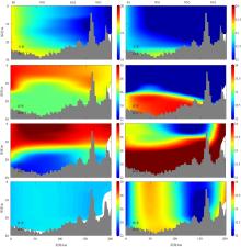
Fig. 2
Vertical distributions of T and S of section NS in 2019"
Fig. 2
Fig. 3
Vertical distributions of nutrients of section NS in 2019"
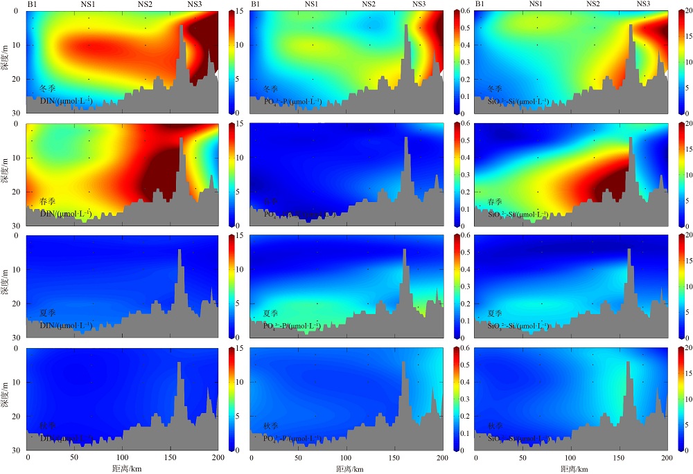
Fig. 3
Tab. 2
Range and average of T, S, and nutrients of section A in 2019"
| 参数 | 温度/℃ | 盐度/‰ | DIN浓度/(μmol·L-1) | PO43--P浓度/(μmol·L-1) | SiO32--Si浓度/(μmol·L-1) | |
|---|---|---|---|---|---|---|
| 冬季 | 变化范围 | 7.71~24.09 | 31.75~34.76 | 0.42~31.45 | 0.02~2.49 | 0.05~76.16 |
| 平均值±S.D. | 16.58±5.49 | 34.41±0.33 | 5.61±7.40 | 0.41±0.59 | 9.66±16.41 | |
| 春季 | 变化范围 | 8.24~29.54 | 23.67~34.79 | 1.02~27.17 | 0.01~2.46 | 1.09~67.55 |
| 平均值±S.D. | 16.90±6.52 | 34.40±0.49 | 5.75±6.52 | 0.35±0.48 | 9.10±13.07 | |
| 夏季 | 变化范围 | 7.99~30.58 | 31.68~34.68 | 1.01~20.33 | 0.03~2.45 | 0.11~57.19 |
| 平均值±S.D. | 17.26±7.12 | 34.31±0.45 | 5.06±4.98 | 0.49±0.61 | 8.45±11.62 | |
| 秋季 | 变化范围 | 8.23~26.14 | 33.53~34.82 | 1.05~26.19 | 0.04~2.11 | 1.61~52.52 |
| 平均值±S.D. | 17.87±6.35 | 34.32±0.27 | 5.11±6.13 | 0.40±0.50 | 8.18±11.37 | |
Tab. 2
Fig. 4
Vertical distributions of T and S of section A in 2019 The white closed dotted line is the Kuroshio water mass, and the white dotted line segment is the Pearl River plume (S<33‰) water mass"
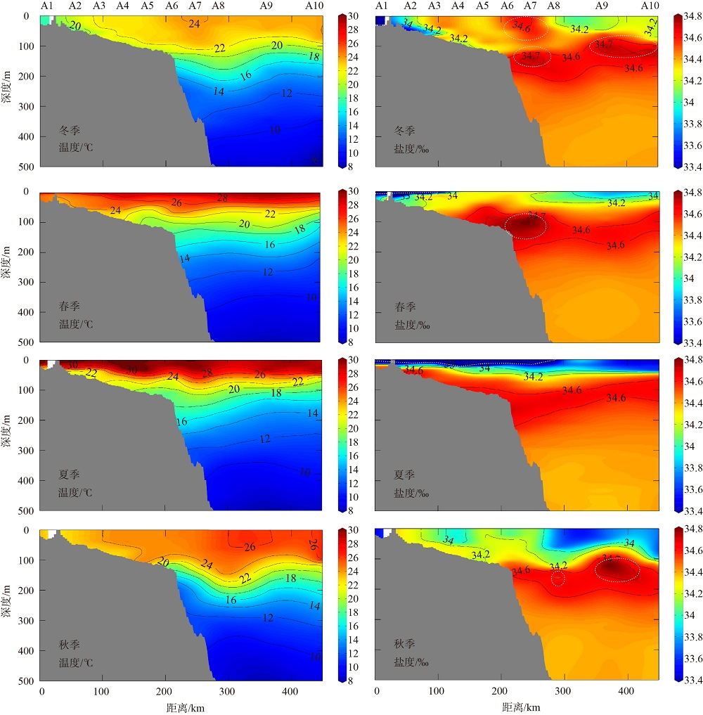
Fig. 4
Fig. 5
Vertical distributions of nutrients of section A in 2019"
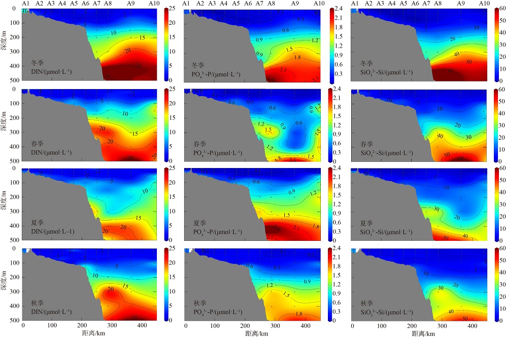
Fig. 5
Tab. 3
Range and average of T, S, and nutrients of section B in 2019"
| 参数 | 温度/℃ | 盐度/‰ | DIN浓度/(μmol·L-1) | PO43--P浓度/(μmol·L-1) | SiO32--Si浓度/(μmol·L-1) | |
|---|---|---|---|---|---|---|
| 冬季 | 变化范围 | 7.96~25.59 | 32.64~34.69 | 0.36~19.39 | 0.02~1.62 | 0.05~51.97 |
| 平均值±S.D. | 17.65±5.53 | 34.36±0.30 | 3.67±3.87 | 0.19±0.28 | 5.05±8.65 | |
| 春季 | 变化范围 | 8.04~30.06 | 30.09~34.68 | 1.34~26.72 | 0.01~2.31 | 0.82~63.03 |
| 平均值±S.D. | 18.12±6.79 | 34.33±0.51 | 6.05±5.83 | 0.30±0.43 | 7.72±12.03 | |
| 夏季 | 变化范围 | 7.90~30.07 | 33.14~34.65 | 1.00~19.8 | 0.01~2.05 | 0.52~51.44 |
| 平均值±S.D. | 17.96±7.02 | 34.38±0.28 | 4.43±4.43 | 0.38±0.49 | 7.11±10.75 | |
| 秋季 | 变化范围 | 8.87~26.01 | 32.54~34.62 | 0.83~24.00 | 0.05~1.92 | 1.59~44.39 |
| 平均值±S.D. | 19.57±6.15 | 34.23±0.35 | 4.21±5.67 | 0.31±0.44 | 6.13±8.97 | |
Tab. 3
Fig.6
Vertical distributions of T and S of section B in 2019 The white closed dotted line is the Kuroshio water mass, and the white dotted line segment is the Pearl River plume (S<33‰) water mass"
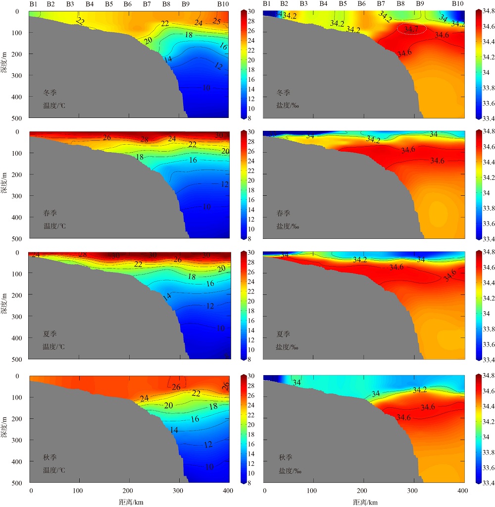
Fig.6
Fig. 7
Vertical distributions of nutrients of section B in 2019"
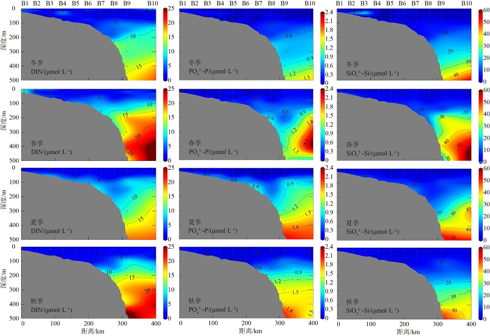
Fig. 7
Tab. 4
Range and average of N:P, Si:P and Si:N in 2019 in nearshore sea"
| 季节 | N:P | Si:P | Si:N | |||
|---|---|---|---|---|---|---|
| 变化范围 | 平均值±S.D. | 变化范围 | 平均值±S.D. | 变化范围 | 平均值±S.D. | |
| 冬季 | 29.3~47.9 | 36.1±5.4 | 24.1~49.7 | 35.8±6.0 | 0.7~1.3 | 1.0±0.2 |
| 春季 | 94.0~1324.6 | 348.3±374.4 | 30.0~1033.0 | 233.3±330.3 | 0.1~1.3 | 0.6±0.4 |
| 夏季 | 8.5~47.8 | 23.9±14.1 | 3.2~41.3 | 20.6±10.9 | 0.1~2.6 | 1.3±0.9 |
| 秋季 | 10.6~21.8 | 14.4±3.3 | 20.1~67.6 | 35.9±13.6 | 1.4~3.6 | 2.5±0.8 |
Tab. 4
Tab. 5
Summary of 23.5 kg·m-3 isoline of iso-density lifting of section A and B in 2019"
| 断面 | 夏季 A断面 | 夏季 B断面 | 春季 A断面 | 春季 B断面 |
|---|---|---|---|---|
| 等密度线起始 站位 | A1 | B1 | A3 | B4 |
| 等密度线两端 水深/m | 29~56 | 24~46 | 59~72 | 49~46 |
| 抬升角度/° | 7.5 | 6.6 | 6.5 | -2.3 |
Tab. 5
Fig. 8
Potential temperature-salinity diagrams in winter (a), spring (b), and autumn (c) The contour line is the seawater density σ0 in kg·m-3, calculated by ODV software. WNP is the contemporaneous Argo profile data of Kuroshio"
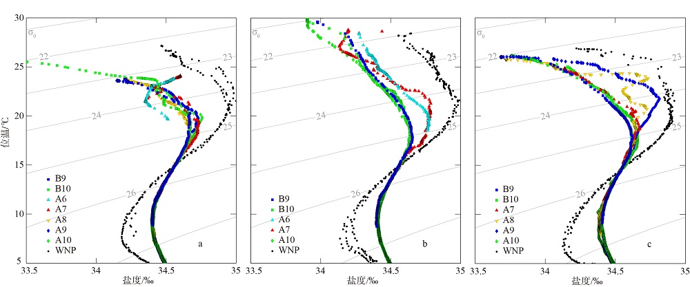
Fig. 8
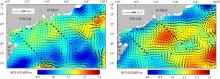
Fig. 9
Absolute dynamic topography and the corresponding surface geostrophic currents"

Fig. 9
| [1] |
陈法锦, 陈淳青, 周凤霞, 等, 2017. 秋季珠江口外海海域的生态环境特征[J]. 海洋环境科学, 36(6): 844-852.
|
|
|
|
| [2] |
冯士筰, 李凤岐, 李少菁, 1999. 海洋科学导论[M]. 北京: 高等教育出版社.
|
|
|
|
| [3] |
高姗, 2011. 南海低营养级生态要素时空分布特征及模型研究[D]. 青岛: 中国海洋大学.
|
|
|
|
| [4] |
韩爱琴, 2012. 南海北部陆架营养盐生物地球化学循环及其与物理过程的耦合研究[D]. 厦门: 厦门大学. (in Chinese)
|
| [5] |
黄亚楠, 陈法锦, 赵辉, 等, 2015. 2012年冬季南海西北部营养盐浓度分布及结构特征[J]. 应用海洋学学报, 34(3): 310-316.
|
|
|
|
| [6] |
柯志新, 黄良民, 谭烨辉, 等, 2013. 2008年夏末南海北部叶绿素a的空间分布特征及其影响因素[J]. 热带海洋学报, 32(4): 51-57.
doi: 10.11978/j.issn.1009-5470.2013.04.008 |
|
|
|
| [7] |
冷晓云, 杨阳, 孙军, 等, 2016. 夏季南海西部中尺度物理过程对营养盐和叶绿素a分布特征的影响[J]. 海洋学报, 38(4): 66-75.
|
|
|
|
| [8] |
李伯志, 2018. 中国近海营养盐季节和年际变化特征分析[D]. 天津: 天津科技大学.
|
|
|
|
| [9] |
李登辉, 2017. 南海北部陆坡区水团分析[D]. 上海: 上海交通大学.
|
|
|
|
| [10] |
廖秀丽, 戴明, 巩秀玉, 等, 2018. 南海南部次表层叶绿素a质量浓度最大值及其影响因子[J]. 热带海洋学报, 37(1): 45-56.
doi: 10.11978/2017020 |
|
|
|
| [11] |
林宏阳, 胡建宇, 郑全安, 2012. 吕宋海峡附近中尺度涡特征的统计分析[J]. 海洋学报, 34(1): 1-7.
|
|
|
|
| [12] |
彭欣, 宁修仁, 孙军, 等, 2006. 南海北部浮游植物生长对营养盐的响应[J]. 生态学报, 26(12): 3959-3968.
|
|
|
|
| [13] |
石晓勇, 李鸿妹, 韩秀荣, 等, 2014. 夏季南海北部典型中尺度物理过程对营养盐及溶解氧分布特征的影响[J]. 环境科学学报, 34(3): 695-703.
|
|
|
|
| [14] |
苏锡宝, 2019. 南海海盆溶解氧和碳酸盐系统的空间分布及主要调控机制[D]. 厦门: 厦门大学.
|
|
|
|
| [15] |
吴敏兰, 2014. 北部湾北部海域营养盐的分布特征及其对生态系统的影响研究[D]. 厦门: 厦门大学.
|
|
|
|
| [16] |
吴日升, 李立, 2003. 南海上升流研究概述[J]. 台湾海峡, 22(2): 269-277.
|
|
|
|
| [17] |
许东禹, 刘锡清, 张训华, 等, 1997. 中国近海地质[M]. 北京: 地质出版社.
|
|
|
|
| [18] |
许金电, 蔡尚湛, 宣莉莉, 等, 2013. 2006年夏季琼东、粤西沿岸上升流研究[J]. 海洋学报, 35(4): 11-18.
|
|
|
|
| [19] |
徐文龙, 王桂芬, 周雯, 等, 2018. 南海东北部夏季叶绿素a浓度垂向变化特征及其对水动力过程的响应[J]. 热带海洋学报, 37(5): 62-73.
doi: 10.11978/2017121 |
|
|
|
| [20] |
许艳苹, 2009. 南海西部冷涡区域上层海洋营养盐的动力学[D]. 厦门: 厦门大学.
|
|
|
|
| [21] |
杨阳, 李锐祥, 朱鹏利, 等, 2014. 珠江冲淡水季节变化及动力成因[J]. 海洋通报, 33(1): 36-44.
|
|
|
|
| [22] |
尹宜舟, 李多, 孙劭, 等, 2020. 2019年全球重大天气气候事件及其成因[J]. 气象, 46(4): 538-546.
|
|
|
|
| [23] |
袁梁英, 2005. 南海北部营养盐结构特征[D]. 厦门: 厦门大学.
|
|
|
|
| [24] |
郑璟, 庞古乾, 杜尧东, 等, 2019. 2019年3—4月广东省天气气候特点及其影响评述[J]. 广东气象, 41(3): 封2, 封3 (in Chinese). (in Chinese)
|
| [25] |
doi: 10.1111/j.0022-3646.1985.00347.x |
| [26] |
pmid: 22457971 |
| [27] |
doi: 10.1016/0278-4343(92)90065-R |
| [28] |
doi: 10.5194/bg-10-6419-2013 |
| [29] |
|
| [30] |
|
| [31] |
doi: 10.1002/rog.v54.3 |
| [32] |
doi: 10.1016/S0272-7714(05)80014-9 |
| [33] |
doi: 10.1007/s00376-011-0068-x |
| [34] |
doi: 10.1007/s10236-011-0426-3 |
| [35] |
doi: 10.1016/j.pocean.2014.05.012 |
| [36] |
doi: 10.3354/meps062283 |
| [37] |
doi: 10.1175/1520-0442(2004)017<3644:CLSTPA>2.0.CO;2 |
| [38] |
|
| [39] |
doi: 10.1016/j.ocemod.2011.01.002 |
| [40] |
doi: 10.1007/s11430-017-9152-y |
| [41] |
doi: 10.1002/2013JC009172 |
| [42] |
doi: 10.1016/j.dsr.2008.05.007 |
| [43] |
doi: 10.1016/j.csr.2004.06.015 |
| No related articles found! |
|
||