
Journal of Tropical Oceanography ›› 2025, Vol. 44 ›› Issue (6): 143-154.doi: 10.11978/2025021CSTR: 32234.14.2025021
Previous Articles Next Articles
Dynamic changes in mangrove wetland of the Maolingjiang Estuary, Qinzhou Gulf
WANG Riming1( ), SU Jinheng1,2, DAI Zhijun3(), WU Tianliang2, XIE Xiaowen2, HUANG Chunmei1, LI Xingrong4, ZHANG Shangyu4
- 1
Guangxi Key Laboratory of Marine Environmental Change and Disaster in Beibu Gulf/College of Resources and Environment ,Beibu Gulf University
2Key Laboratory of Environmental Change and Resource Use in Beibu Gulf ,Ministry of Education, Nanning Normal University
3State Key Laboratory of Estuarine and Costal Research ,East China Normal University
4CCCC-FHDI Engineering Co. ,Ltd.
-
Received:2025-02-11Revised:2025-04-11Online:2025-11-10Published:2025-12-03 -
Contact:DAI Zhijun. email:zjdai@sklec.ecnu.edu.cn -
Supported by:National Natural Science Foundation Key Program of China(41930537); National Natural Science Foundation of China(42366009); Qinzhou Scientific Research and Technology Development Program(20223623)
CLC Number:
- X171.1
Cite this article
WANG Riming, SU Jinheng, DAI Zhijun, WU Tianliang, XIE Xiaowen, HUANG Chunmei, LI Xingrong, ZHANG Shangyu. Dynamic changes in mangrove wetland of the Maolingjiang Estuary, Qinzhou Gulf[J].Journal of Tropical Oceanography, 2025, 44(6): 143-154.
share this article
Add to citation manager EndNote|Reference Manager|ProCite|BibTeX|RefWorks
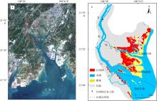
Fig. 1
Location of the study area and mangrove distribution. (a) Study area location; (b) mangrove distribution at Maolingjiang Estuary"

Fig. 1
Tab. 1
Remote sensing image information"
| 序号 | 成像日期 | 时刻 | 卫星 | 分辨率/m | 总体精度OA | Kappa系数 |
|---|---|---|---|---|---|---|
| 1 | 1992-10-23 | 10:32 | Landsat 5 TM | 30 | 0.95 | 0.94 |
| 2 | 1994-11-14 | 10:25 | Landsat 5 TM | 30 | 0.96 | 0.95 |
| 3 | 1996-12-21 | 10:33 | Landsat 5 TM | 30 | 0.95 | 0.94 |
| 4 | 1997-08-18 | 10:42 | Landsat 5 TM | 30 | 0.96 | 0.95 |
| 5 | 1998-08-21 | 10:49 | Landsat 5 TM | 30 | 0.92 | 0.91 |
| 6 | 1999-09-25 | 10:47 | Landsat 5 TM | 30 | 0.94 | 0.92 |
| 7 | 2000-09-11 | 10:49 | Landsat 5 TM | 30 | 0.96 | 0.95 |
| 8 | 2002-11-04 | 10:43 | Landsat 5 TM | 30 | 0.95 | 0.94 |
| 9 | 2003-04-13 | 10:45 | Landsat 5 TM | 30 | 0.93 | 0.92 |
| 10 | 2004-06-02 | 10:52 | Landsat 5 TM | 30 | 0.95 | 0.94 |
| 11 | 2006-12-17 | 11:05 | Landsat 5 TM | 30 | 0.97 | 0.96 |
| 12 | 2007-07-29 | 11:04 | Landsat 5 TM | 30 | 0.98 | 0.98 |
| 13 | 2008-05-12 | 10:59 | Landsat 5 TM | 30 | 0.97 | 0.96 |
| 14 | 2009-05-31 | 10:59 | Landsat 5 TM | 30 | 0.97 | 0.97 |
| 15 | 2011-06-22 | 11:00 | Landsat 5 TM | 30 | 0.96 | 0.95 |
| 16 | 2013-11-02 | 11:12 | Landsat 8 OLI | 30 | 0.93 | 0.92 |
| 17 | 2014-06-14 | 11:10 | Landsat 8 OLI | 30 | 0.93 | 0.91 |
| 18 | 2015-04-14 | 11:10 | Landsat 8 OLI | 30 | 0.96 | 0.95 |
| 19 | 2017-05-05 | 11:10 | Landsat 8 OLI | 30 | 0.95 | 0.94 |
| 20 | 2018-07-11 | 11:10 | Landsat 8 OLI | 30 | 0.98 | 0.98 |
| 21 | 2019-08-15 | 11:11 | Landsat 8 OLI | 30 | 0.98 | 0.98 |
| 22 | 2020-09-02 | 11:11 | Landsat 8 OLI | 30 | 0.98 | 0.98 |
| 23 | 2021-04-30 | 11:10 | Landsat 8 OLI | 30 | 0.96 | 0.96 |
Tab. 1
Tab. 2
Remote sensing image data and tide level information"
| 序号 | 成像时间 | 时刻 | 卫星 | 分辨率/m | 潮位/cm |
|---|---|---|---|---|---|
| 1 | 1992-10-23 | 10:32 | Landsat 5 TM | 30 | 288 |
| 2 | 1997-08-02 | 10:42 | Landsat 5 TM | 30 | 298 |
| 3 | 2002-11-04 | 10:43 | Landsat 5 TM | 30 | 297 |
| 4 | 2007-07-29 | 11:04 | Landsat 5 TM | 30 | 279 |
| 5 | 2014-06-14 | 11:10 | Landsat 8 OLI | 30 | 297 |
| 6 | 2021-04-30 | 11:10 | Landsat 8 OLI | 30 | 280 |
Tab. 2
Tab. 3
Monitoring of tidal flat elevation section"
| 断面序号 | 平均坡度 | L/m |
|---|---|---|
| D1 | 0.22% | 85.90 |
| D2 | 0.69% | 27.35 |
| D3 | 0.39% | 48.25 |
| D4 | 0.24% | 79.22 |
Tab. 3
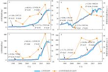
Fig. 2
Mangrove dynamic changes at Maolingjiang Estuary from 1992 to 2021. (a) Interannual variation of mangroves; (b) Liangwu tidal flat; (c) Tuanhedao tidal flat; (d) Dalidun tidal flat"

Fig. 2
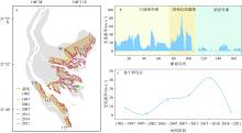
Fig. 3
Seaward expansion trend of mangroves at Maolingjiang Estuary. (a) Dynamic changes of mangrove fringe line; (b) change rate of mangrove fringe line in regional mangrove; (c) interannual variation of mangrove fringe line"

Fig. 3
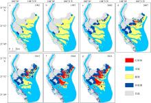
Fig. 4
Spatial distribution of mangroves at Maolingjiang Estuary from 1992 to 2021"

Fig. 4
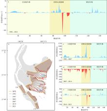
Fig. 5
Dynamic changes in tidal flat water boundary line at Maolingjiang Estuary. (a) Change rate of the water boundary line from 1992 to 2021; (b) dynamic changes in water boundary line from 1992 to 2021; (c) migration distance of tidal flat water boundary line from 1992 to 2007; (d) migration distance of tidal flat water boundary line from 2007 to 2014; (e) migration distance of tidal flat water boundary line from 2014 to 2021"

Fig. 5
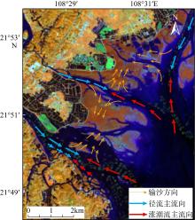
Fig. 6
Transport pathways of suspended sediments in the Maolingjiang Estuary"

Fig. 6
Tab. 4
Area of mangrove encroachment by different land types"
| 年份 | 裸滩面积/hm2 | 水域(养殖塘)面积/hm2 | 其他面积/hm2 |
|---|---|---|---|
| 1992—1997 | 1.25 | 0.08(0.00) | 0.17 |
| 1997—2002 | 6.07 | 7.49(4.74) | 1.17 |
| 2002—2007 | 1.25 | 0.92(0.67) | 0.67 |
| 2007—2013 | 2.00 | 3.83(0.67) | 0.33 |
| 2013—2018 | 4.58 | 6.32(4.24) | 5.37 |
| 2018—2021 | 27.58 | 14.89(11.23) | 3.25 |
| 总和 | 42.72 | 33.53(21.55) | 10.94 |
Tab. 4
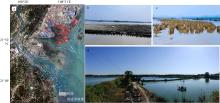
Fig. 7
Human activities in the study area. (a) Distribution of oyster rafts and aquaculture ponds in the Maolingjiang Estuary; (b) oyster rafts in the Maolingjiang Estuary; (c) oyster culture poles in the Maolingjiang Estuary; (d) constructed aquaculture ponds"

Fig. 7
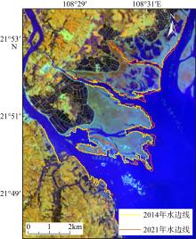
Fig. 8
Changes in tidal flat water boundary line before and after channel dredging"

Fig. 8
| [1] |
陈高, 钟才荣, 李明玉, 等, 2022. 1990年—2020年广西北仑河口红树林扰动研究[J]. 遥感学报, 26(6): 1112-1120.
|
|
doi: 10.11834/jrs.20221579 |
|
| [2] |
陈顺洋, 安文硕, 陈彬, 等, 2021. 红树林生态修复固碳效果的主要影响因素分析[J]. 应用海洋学学报, 40(1): 34-42.
|
|
|
|
| [3] |
陈一宁, 陈鹭真, 2023. 滨海蓝碳生态系统的碳库间相互作用研究进展及展望[J]. 海洋学研究, 41(1): 3-13.
doi: 10.3969-j.issn.1001-909X.2023.01.001 |
|
doi: 10.3969-j.issn.1001-909X.2023.01.001 |
|
| [4] |
陈主器, 2021. 广西钦州大蚝苗种产业发展的问题与对策[J]. 养殖与饲料, 20(11): 166-167 (in Chinese).
|
| [5] |
戴志军, 周晓妍, 王杰, 等, 2021. 红树林潮滩沉积动力研究进展与展望[J]. 热带海洋学报, 40(3): 69-75.
doi: 10.11978/YG2020007 |
|
doi: 10.11978/YG2020007 |
|
| [6] |
邓建明, 姚航, 付波霖, 等, 2025. 基于GEE和时序主被动影像的广西北部湾红树林时空动态监测研究[J]. 自然资源遥感, 37(2): 235-245.
|
|
|
|
| [7] |
范航清, 莫竹承, 2018. 广西红树林恢复历史、成效及经验教训[J]. 广西科学, 25(4): 363-371+387.
|
|
|
|
| [8] |
郭晋宇, 耿晓晓, 尹雷, 等, 2023. 海南儋州湾贝克喜盐草资源分布特征及影响因素分析[J]. 海洋湖沼通报, 45(2): 123-132.
doi: 10.13984/j.cnki.cn37-1141.2023.02.016 |
|
|
|
| [9] |
黄李丛, 苏宏河, 唐丰利, 2013. 钦州市引种无瓣海桑现状及发展对策分析[J]. 广东科技, 22 (14): 188-189 (in Chinese).
|
| [10] |
贾明明, 王宗明, 毛德华, 等, 2021. 面向可持续发展目标的中国红树林近50年变化分析[J]. 科学通报, 66(30): 3886-3901.
|
|
|
|
| [11] |
李春干, 代华兵, 2015. 1960—2010年广西红树林空间分布演变机制[J]. 生态学报, 35(18): 5992-6006.
|
|
|
|
| [12] |
李瑞利, 杨芳, 王辉, 等, 2022. 红树林保护与修复标准发展现状及对策[J]. 北京大学学报(自然科学版), 58(5): 916-928.
|
|
|
|
| [13] |
梁喜幸, 王日明, 戴志军, 等, 2023. 茅尾海钦江河口光滩时空变化过程研究[J]. 海洋地质与第四纪地质, 43(3): 107-118.
|
|
|
|
| [14] |
马进荣, 程梦妍, 廖文凯, 等, 2019. 广西茅岭江入海典型污染物通量估算方法[J]. 广西科学, 26(3): 335-340.
|
|
|
|
| [15] |
潘嵩, 王慧, 李欢, 等, 2020. 基于SLAMM模型的海平面上升对广西沿海红树林影响研究[J]. 海洋通报, 39(3): 325-334.
|
|
|
|
| [16] |
申键, 简焯锴, 欧阳雪敏, 等, 2024. 结合潮位校正的雷州半岛红树林湿地动态变迁遥感监测[J]. 热带海洋学报, 43(1): 137-153.
|
|
|
|
| [17] |
汪振松, 冯志勇, 陈鹏, 等, 2022. 近30年深圳湾红树林群落演变过程及其对人类活动的响应[J]. 中国农村水利水电, (12): 24-30.
doi: 10.12396/znsd.220428 |
|
|
|
| [18] |
王日明, 戴志军, 黄鹄, 等, 2021. 南流江河口桐花树生物动力地貌过程研究[J]. 海洋学报, 43(9): 102-114.
|
|
|
|
| [19] |
王日明, 黄鹄, 2020. 南流江口洲滩景观过程研究[J]. 海洋科学, 44(12): 84-92.
|
|
|
|
| [20] |
王日明, 梁喜幸, 周晓妍, 等, 2022. 钦江河口潮滩红树林群落空间分布[J]. 遥感学报, 26(6): 1143-1154.
|
|
doi: 10.11834/jrs.20221540 |
|
| [21] |
吴庭天, 丁山, 陈宗铸, 等, 2020. 基于LUCC和景观格局变化的海南东寨港红树林湿地动态研究[J]. 林业科学研究, 33(5): 154-162.
|
|
|
|
| [22] |
杨钰文, 卢远, 黄萍, 2020. 基于遥感的北部湾茅尾海岸滩时空变化研究[J]. 海洋技术学报, 39(4): 1-8.
|
|
|
|
| [23] |
于凌云, 林绅辉, 焦学尧, 等, 2019. 粤港澳大湾区红树林湿地面临的生态问题与保护对策[J]. 北京大学学报(自然科学版), 55(4): 782-790.
|
|
|
|
| [24] |
张文良, 郭俊丽, 刘卓成, 等, 2025. 钦州湾与马尼拉湾岸线时空变化与围填海分析[J]. 热带地理, 45(3): 489-503.
doi: 10.13284/j.cnki.rddl.20240441 |
|
doi: 10.13284/j.cnki.rddl.20240441 |
|
| [25] |
doi: 10.1038/s41598-018-31683-0 pmid: 30185918 |
| [26] |
doi: 10.1080/01431160802575653 |
| [27] |
doi: 10.1038/ngeo1123 |
| [28] |
doi: 10.1080/014311699211813 |
| [29] |
doi: 10.1016/j.aquabot.2007.12.009 |
| [30] |
doi: 10.1111/geb.2011.20.issue-1 |
| [31] |
doi: 10.1111/gcb.v26.10 |
| [32] |
doi: 10.1080/014311698215801 |
| [33] |
doi: 10.3390/rs14236026 |
| [34] |
doi: 10.1016/S0034-4257(02)00096-2 |
| [35] |
doi: 10.1111/nph.12605 pmid: 24251960 |
| [36] |
doi: 10.1016/j.foreco.2021.119855 |
| [37] |
|
| [38] |
|
| [39] |
doi: 10.1007/s13131-022-2126-x |
| [40] |
doi: 10.1016/j.catena.2023.107601 |
| [41] |
doi: 10.1080/01431160600589179 |
| [1] | GAO Shu, JIA Jianjun, YU Qian. Green sea dykes: an overview of their principles of sediment, geomorphology and ecosystem dynamics [J]. Journal of Tropical Oceanography, 2022, 41(4): 1-19. |
| [2] | DAI Zhijun, ZHOU Xiaoyan, WANG Jie, HU Baoqing. Review and prospect of mangrove tidal flat sedimentary dynamics [J]. Journal of Tropical Oceanography, 2021, 40(3): 69-75. |
|
||