
Journal of Tropical Oceanography >
Geomorphological records of turbidity current activity in the northeastern margin of the South China Sea and analysis of triggering mechanism
Received date: 2020-02-26
Request revised date: 2020-05-24
Online published: 2020-06-11
Supported by
Pioneer Hundred Talents Program of the Chinese Academy of Sciences(Y8YB011001)
Copyright
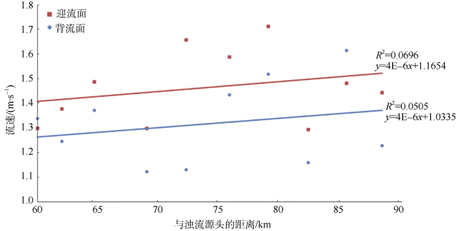
Cyclic steps caused by supercritical turbidity currents are distributed widely along the West Penghu Canyon in the Taixinan Basin of the northeastern South China Sea. Turbidity currents occur frequently in this area due to high tectonic activities, marine factors such as typhoon and delivery of large sediments from rivers. Using high-resolution bathymetric data, we conduct quantitative analysis on the morphology of 23 net-erosional cyclic steps and 10 net-depositional cyclic steps along the West Penghu Canyon, and compute flow velocity of turbidity currents flowing through these cyclic steps. We find that the flow velocity of turbidity currents has an abrupt change in the transition of net-erosional cyclic steps, while the velocity decreases significantly in the transition from net-erosional to net-depositional cyclic steps. The former is mainly caused by the slope break in the canyon, while the latter is caused by the change from confined to unconfined environment. In addition, the net-depositional cyclic steps are located closer to the southwestern flank of the West Penghu Canyon; and we propose that this phenomenon should be mainly caused by turbidity currents affected by the Coriolis force. Investigating the evolution and controlling factors of cyclic steps in this area can help us better understand the interaction of submarine bedforms and turbidity currents, which plays a significant role in the geomorphological evolution along submarine canyons.
LI Shuang , LI Wei , ZHAN Wenhuan . Geomorphological records of turbidity current activity in the northeastern margin of the South China Sea and analysis of triggering mechanism[J]. Journal of Tropical Oceanography, 2021 , 40(1) : 111 -121 . DOI: 10.11978/2020022
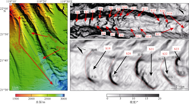
图3 净侵蚀周期阶坎地貌图(a)与坡度图(b、c)Fig. 3 Geomorphologic (a) and slope gradient (b, c) maps of net-erosional cyclic steps |
表1 净侵蚀周期阶坎形态特征统计结果Tab. 1 Morphological characteristics of net-erosional cyclic steps |
| H1/m | W1/m | H3/m | W3/m | α/° | β/° | θ/° | Lstep/m | Hstep/m | Ay | |
|---|---|---|---|---|---|---|---|---|---|---|
| S1 | 463 | 6980 | 445 | 6737 | 1.24 | 1.26 | 0.89 | 2611 | 48 | 0.18 |
| S2 | 362 | 7022 | 354 | 6573 | 1.18 | 3.85 | 2.71 | 1729 | 90 | 0.27 |
| S3 | 421 | 6508 | 323 | 6871 | 2.36 | 2.69 | 1.07 | 2730 | 87 | 0.45 |
| S4 | 359 | 7070 | 334 | 6732 | 1.28 | 6.41 | 3.14 | 2267 | 146 | 0.49 |
| S5 | 376 | 7031 | 332 | 6997 | 2.64 | 3.13 | 1.43 | 1825 | 70 | 0.43 |
| S6 | 378 | 7225 | 310 | 7609 | 1.78 | 1.88 | 0.35 | 1565 | 24 | 1.29 |
| S7 | 325 | 7179 | 300 | 7161 | 0.85 | 3.40 | 2.43 | 2350 | 108 | 0.28 |
| S8 | 315 | 8031 | 297 | 8202 | 0.64 | 4.58 | 1.60 | 1347 | 47 | 1.17 |
| S9 | 355 | 7884 | 316 | 8191 | 1.17 | 1.30 | 0.34 | 2309 | 32 | 0.67 |
| S10 | 325 | 8357 | 283 | 8692 | 1.25 | 6.05 | 2.06 | 1514 | 75 | 1.04 |
| S11 | 350 | 8855 | 321 | 9291 | 2.00 | 1.82 | 0.60 | 3311 | 70 | 0.44 |
| S12 | 290 | 9132 | 263 | 9135 | 0.24 | 2.21 | 1.61 | 1609 | 47 | 0.49 |
| S13 | 308 | 9225 | 275 | 9370 | 1.55 | 1.11 | 0.38 | 2425 | 34 | 0.41 |
| S14 | 299 | 9501 | 275 | 9519 | 0.95 | 1.19 | 0.56 | 2731 | 40 | 0.52 |
| S15 | 267 | 9538 | 212 | 9978 | 1.90 | 2.69 | 0.99 | 2263 | 68 | 0.45 |
| S16 | 219 | 7013 | 202 | 7369 | 0.43 | 1.78 | 0.87 | 2821 | 51 | 0.71 |
| S17 | 200 | 7327 | 182 | 7523 | 0.65 | 1.87 | 0.91 | 2059 | 44 | 0.82 |
| S18 | 219 | 7740 | 198 | 8161 | 0.42 | 1.15 | 0.38 | 1616 | 17 | 0.96 |
| S19 | 110 | 6189 | 38 | 6349 | 0.90 | 2.89 | 0.63 | 3486 | 71 | 1.45 |
| S20 | 93 | 5592 | 20 | 5529 | 1.17 | 1.98 | 0.46 | 4730 | 93 | 0.99 |
| S21 | 98 | 5995 | 19 | 6317 | 1.34 | 1.62 | 0.33 | 3258 | 46 | 2.03 |
| S22 | 47 | 4108 | 32 | 5077 | 1.09 | 3.16 | 1.36 | 2478 | 79 | 0.78 |
| S23 | 101 | 4195 | 39 | 5007 | 1.53 | 2.46 | 2.30 | 1479 | 30 | 1.45 |
| 误差 | ±0.08 | ±0.02 | ±0.11 | ±0.02 | ±0.10 | ±0.12 | ±0.18 | ±0.05 | ±0.18 | ±0.10 |
注: H1为水跃前的峡谷有效高度; H3为水跃后的峡谷有效高度; W1为水跃前的峡谷有效宽度; W3为水跃后的峡谷有效宽度; α为周期阶坎的迎流面坡度; β为周期阶坎的背流面坡度; θ为周期阶坎的坡度; Lstep为周期阶坎的波长; Hstep为周期阶坎的波高; Ay为周期阶坎的对称指数 |
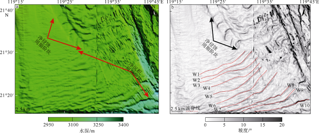
表2 净沉积周期阶坎形态特征统计结果Tab. 2 Morphological characteristics of net-depositional cyclic steps |
| α/° | β/° | θ/° | Lstoss/m | Llee/m | Lstep/m | Hstep/m | Ay | |
|---|---|---|---|---|---|---|---|---|
| W1 | 1.01 | 1.74 | 0.61 | 876 | 603 | 2248 | 36 | 1.06 |
| W2 | 0.99 | 2.74 | 0.82 | 1158 | 1090 | 2228 | 43 | 0.82 |
| W3 | 0.72 | 1.62 | 0.72 | 1002 | 1226 | 2647 | 55 | 0.85 |
| W4 | 2.19 | 2.83 | 0.36 | 1216 | 1431 | 1905 | 65 | 0.75 |
| W5 | 0.97 | 1.32 | 0.70 | 815 | 1090 | 2602 | 45 | 0.47 |
| W6 | 1.56 | 2.24 | 0.95 | 826 | 1776 | 2962 | 78 | 0.81 |
| W7 | 0.74 | 1.49 | 0.49 | 1330 | 1632 | 3387 | 58 | 0.79 |
| W8 | 0.29 | 4.43 | 1.08 | 1490 | 1897 | 1951 | 73 | 0.80 |
| W9 | 2.26 | 3.81 | 1.73 | 869 | 1082 | 3104 | 94 | 1.19 |
| W10 | 1.58 | 3.80 | 1.03 | 1685 | 1419 | 2323 | 84 | 0.72 |
| 误差 | ±0.11 | ±0.08 | ±0.08 | ±0.03 | ±0.02 | ±0.02 | ±0.02 | ±0.04 |
注: α为周期阶坎的迎流面坡度; β为周期阶坎的背流面坡度; θ为周期阶坎的坡度; Lstoss为周期阶坎迎流面的长度; Llee为周期阶坎迎流面的长度; Lstep为周期阶坎的波长; Hstep为周期阶坎的波高; Ay为周期阶坎对称性 |
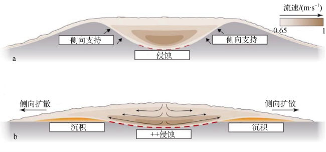
图7 浊流从破折带上部(a)至下部(b)的流体松弛现象[修改自Leeuw等(2016)和Pohl等(2019)]“+”代表侵蚀加剧 Fig. 7 Flow relaxation caused by turbidity currents flowing through the upper (a) and lower (b) reaches of the slope break (modified from Leeuw et al, 2016; Pohl et al, 2019).“+” denotes an increase of erosion |
| [1] |
丁巍伟, 李家彪, 韩喜球, 等, 2010. 南海东北部海底沉积物波的形态、粒度特征及物源、成因分析[J]. 海洋学报, 32(2):96-105.
|
| [2] |
聂鑫, 罗伟东, 周娇, 2017. 南海东北部澎湖峡谷群沉积特征[J]. 海洋地质前沿, 33(8):18-23.
|
| [3] |
王海荣, 王英民, 邱燕, 等, 2008. 南海东北部台湾浅滩陆坡的浊流沉积物波的发育及其成因的构造控制[J]. 沉积学报, 26(1):39-45.
|
| [4] |
王龙樟, 姚永坚, 林卫兵, 等, 2018. 南海南部沉积物波: 软变形及其触发机制[J]. 地球科学, 43(10):3462-3470.
|
| [5] |
吴哲, 杨风丽, 钟家良, 等, 2012. 台西南盆地岩石圈伸展及裂后沉降特征分析[J]. 同济大学学报(自然科学版), 40(11):1730-1736.
|
| [6] |
徐景平, 2014. 海底浊流研究百年回顾[J]. 中国海洋大学学报, 44(10):98-105.
|
| [7] |
许小勇, 吕福亮, 王大伟, 等, 2018. 周期性阶坎的特征及其对深水沉积研究的意义[J]. 海相油气地质, 23(4):1-14.
|
| [8] |
易海, 钟广见, 马金凤, 2007. 台西南盆地新生代断裂特征与盆地演化[J]. 石油实验地质, 29(6):560-564.
|
| [9] |
殷绍如, 王嘹亮, 郭依群, 等, 2015. 东沙海底峡谷的地貌沉积特征及成因[J]. 中国科学: 地球科学, 45(3):275-289.
|
| [10] |
|
| [11] |
|
| [12] |
|
| [13] |
|
| [14] |
|
| [15] |
|
| [16] |
|
| [17] |
|
| [18] |
|
| [19] |
|
| [20] |
|
| [21] |
|
| [22] |
|
| [23] |
|
| [24] |
|
| [25] |
|
| [26] |
|
| [27] |
|
| [28] |
|
| [29] |
|
| [30] |
|
| [31] |
|
| [32] |
|
| [33] |
|
| [34] |
|
| [35] |
|
| [36] |
|
| [37] |
|
| [38] |
|
| [39] |
|
| [40] |
|
| [41] |
|
| [42] |
|
| [43] |
|
/
| 〈 |
|
〉 |


