Journal of Tropical Oceanography >
Study on the geological structural characteristics of the U-shaped boundary in the South China Sea
Editor: LIN Qiang
Received date: 2025-06-04
Revised date: 2025-10-10
Online published: 2025-10-15
Supported by
Guangdong Special Support Talent Team Program(2019BT02H594)
PI Project of Southern Marine Science and Engineering Guangdong Laboratory (Guangzhou)(GML2021GD0810)
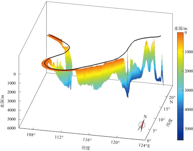
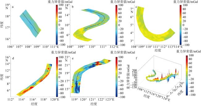
The U-shaped boundary in the South China Sea (SCS) represents China's jurisdictional boundary in the region. It is a critical area for safeguarding national maritime rights and interests and advancing the strategy of building a maritime power. Understanding the geological structure characteristics underlying the U-shaped boundary in the SCS is of great scientific significance. This study focuses on these characteristics, using global bathymetric, gravity, and magnetic data to obtain the depth of the U-shaped boundary (belt). By considering the different nature of the boundary surrounding the SCS, this paper analyzes the structural characteristics of each section of the U-shaped boundary, and discusses their relationship with the rupture and evolution of the SCS. The research reveals that the water depth along the U-shaped boundary presents a pattern of “shallow in the west, flat in the south, and deep in the east”, ranging from 0 to 5400 meters. The gravity anomaly is predominantly negative (-100 to 0 mGal), with localized positive anomalies associated with seamounts. The positive and negative anomaly characteristics of each section correlate well with the topography. Magnetic anomalies along the U-shaped boundary are generally positive, ranging from -50 to 100 nT, reflecting magnetic variations and the spatial occurrence of subsurface rocks. The study also analyzes the alignment of the U-shaped boundary’s strike with submarine geomorphic and tectonic units, as well as the sectional characteristics. In the western section, the strike is consistent with the Red River Fault system and the western margin of the SCS. Sections U1 and U2 exhibit compressive folds and negative flower-like structures under a strike-slip extensional setting. The southern U-shaped boundary overlaps with the slope break of the southern shelf and the Nansha Trough, showing a large-scale rupture unconformity at the Early-Middle Miocene interface. The strike of the U5 section is consistent with the Manila Trench, where the SCS plate subducts beneath the Philippine Sea plate. Overall, the U-shaped boundary is located within the gradient zones of abnormally intense gravitational changes at the western, southeastern and eastern margins of the SCS. It represents significant topographic undulations and serves as both a structural boundary and a natural dividing line. This study provides a richer data foundation and geological references for the U-shaped boundary, providing support for maritime delimitation and disaster prevention and mitigation in the South China Sea.
ZHANG Yunfan , TANG Danling , SUN Zhen , QIU Ning . Study on the geological structural characteristics of the U-shaped boundary in the South China Sea[J]. Journal of Tropical Oceanography, 2026 , 45(3) : 10 -24 . DOI: 10.11978/2025073
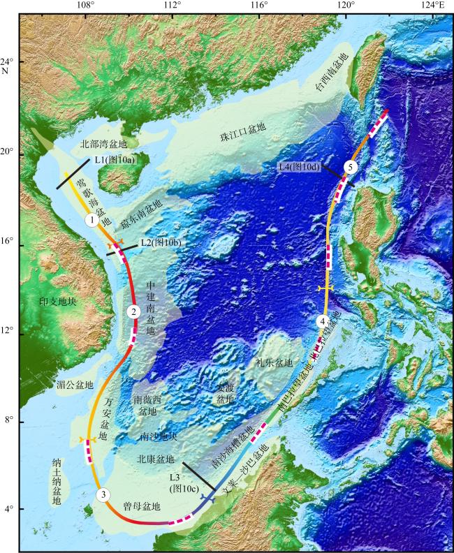
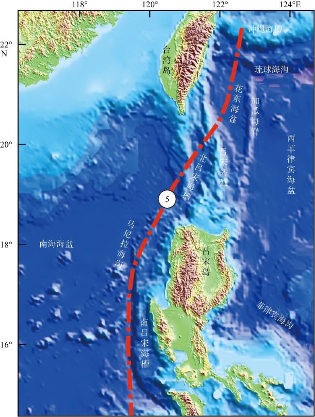
图1 南海U形线与南海区域构造地质图该图基于自然资源部标准地图服务网站下载的审图号为 GS(2016)1613号的标准地图制作。图中彩色带为U形海疆线, 浅黄色为南海周缘盆地。序号为U形线5区间分法: 1为西北段、2为西区段、3为南区段、4为东区段、5为东北段。红色虚线为九段线根据南海地形分布图(罗伟东, 2023)绘制 Fig. 1 U-shaped boundary in the South China Sea and regional tectonic-geological map of the South China Sea. The color belt represents the U-shaped boundary, while the light yellow areas denote the peripheral basins of the South China Sea. The numbers indicate five sectional intervals of the U-shaped boundary: 1 for the U-NW section, 2 for the U-W section, 3 for the U-S section, 4 for the U-E section, and 5 for the U-NE section. The red dashed line depicts the nine-dash line, drawn based on the topographic map of the South China Sea (Luo, 2023) |
图2 南海U形线水深立体图Fig. 2 Three-dimensional depth map of the U-shaped boundary in the South China Sea |
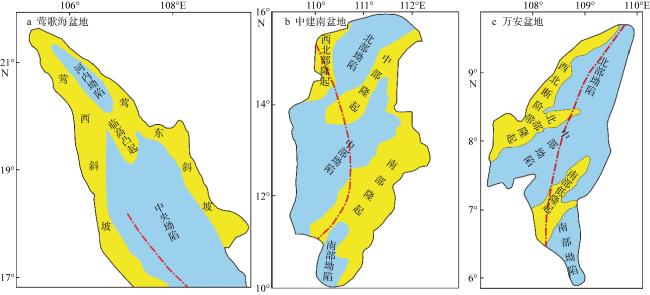
图3 南海U形线与莺歌海盆地、中建南盆地、万安盆地构造单元图图中红色点划线为U形线, 蓝色区域为坳陷, 黄色区域为隆起。根据许璐(2018)、王伟平 等(2022)和肖鸿议 等(2021)修改 Fig. 3 Map of the U-shaped boundary in the South China Sea and the structural geological units of the Yinggehai Basin, Zhongjiannan Basin, and Wan’an Basin. The red dash-dotted lines are the U-shaped boundary, the blue areas represent depressions, and the yellow areas represent uplifts. Modified from Xu (2018), Wang et al (2022), and Xiao et al (2021) |
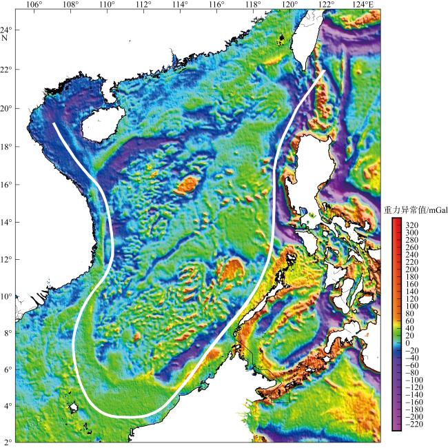
图4 南海U形海疆线分段重力异常平面图与立体图a.西北段重力异常平面图; b. 西区段重力异常平面图; c. 南区段重力异常平面图; d. 东区段重力异常平面图; e. 东北段重力异常平面图; f. U形线重力异常立体图 Fig. 4 Gravity anomaly of five sections in the U-shaped boundary. (a) Gravity anomaly of the U-NW section; (b) gravity anomaly of the U-W section; (c) gravity anomaly of the U-S section; (d) gravity anomaly of the U-E section; (e) gravity anomaly of the U-NE section; (f) 3D view of the U-shaped boundary gravity anomaly |
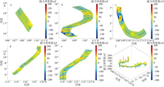
图5 南海U形海疆线分段线磁力异常平面图与立体图a.西北段磁力异常平面图; b. 西区段磁力异常平面图; c. 南区段磁力异常平面图; d. 东区段磁力异常平面图; e. 东北段磁力异常平面图; f. U形线磁力异常立体图 Fig. 5 Magnetic anomaly of five sections in the U-shaped boundary. (a) Magnetic anomaly of the U-NW section; (b) magnetic anomaly of the U-W section; (c) magnetic anomaly of the U-S section; (d) magnetic anomaly of the U-E section; (e) magnetic anomaly of the U-NE section; (f) 3D view of the U-shaped boundary magnetic anomaly |
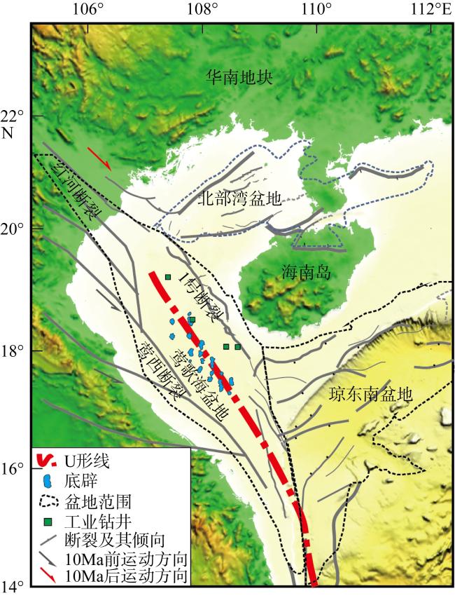
图6 南海U形线西北段构造特征平面图红色点划线为U形线, 黑色线段为断裂, 蓝色点为底辟构造, 根据Lei等(2015)识别 Fig. 6 Planar structural characteristics of the U-NW section of the U-shaped boundary in the South China Sea. The red dotted line represents the U-shaped boundary, the black lines denote faults, and the blue dots indicate diapiric structures, as identified by Lei et al (2015) |
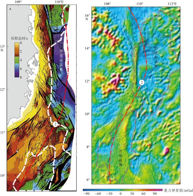
图7 南海U形线西区段构造特征与南海西缘断裂的断裂走向a.断裂平面分布图; b. 自由空气重力异常图。根据Fyhn等(2009)修改, 数字2为U形线西区段 Fig. 7 Direction and structural characteristics of the U-W section and Western Margin Fault, South China Sea. (a) Distribution of the fault; (b) gravity anomaly of the fault. Adapted from Fyhn et al (2009), with numeral 2 indicating the U-W section of the U-shaped boundary |
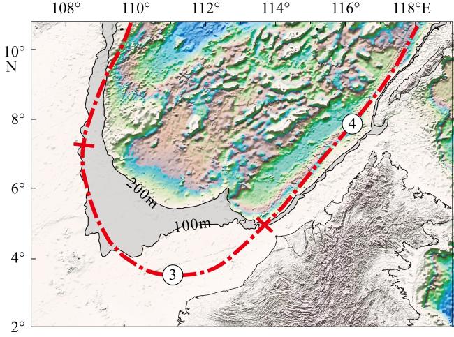
图8 南海U形线南区段、东区段与南海南部陆架坡折灰色阴影为水深100~200m区域, 编号3为U形线南区段, 编号4为U形线东区段 Fig. 8 Shapes of the U-S and U-E sections of the U-shaped boundary and shelf breaks in the southern South China Sea. The grey shade is the area with water depths from 100 to 200 meters. Numerals 3 and 4 are the U-S section and the U-E section of the U-shaped boundary, respectively |
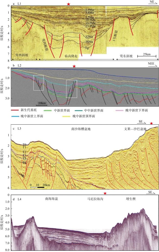
图10 横跨U形线的地震剖面测线位置见图1, 红五角星代表U形线大致位置。L1为U形线西北段莺歌海盆地地震剖面解释图(Sun et al, 2003; Lei et al, 2015); L2为U形线西区段南海西缘断裂地震剖面构造图(Vu et al, 2017); L3为U形线东区段南沙地块地震剖面解释图(姚永坚, 2023); L4为U形线东北段马尼拉俯冲带地震剖面构造图(Chang et al, 2012) Fig. 10 Seismic profiles perpendicular to the U-shaped boundary. The position of the survey line is shown in Fig. 1. The red star represents the U-shaped boundary location. L1 is the seismic profile of the Yinggehai Basin of the U1 section (adapted from Sun et al, 2003; Lei et al, 2015). L2 is the seismic profile of the negative flower-shaped structure of the Western Margin Fault, with the white frame indicating the negative flower-shaped structures (adapted from Vu et al, 2017); L3 is the seismic profile of the Nansha Block (adapted from Yao et al, 2023); L4 is the seismic profile of Manila Trench in the U5 section (adapted from Chang et al, 2012) |
| [1] |
龚再升, 李思田, 谢泰俊, 等, 1997. 南海北部大陆边缘盆地分析与油气聚集[M]. 北京: 科学出版社: 12-16.
|
| [2] |
郭令智, 钟志洪, 王良书, 等, 2001. 莺歌海盆地周边区域构造演化[J]. 高校地质学报, 7(1): 1-12.
|
| [3] |
高红芳, 2011. 南海西缘断裂带走滑特征及其形成机理初步研究[J]. 中国地质, 38(3): 537-543.
|
| [4] |
罗伟东, 胡小三, 周娇, 等, 2023. 南海及邻域海底地形地貌[M], 北京: 科学出版社: 12-16.
|
| [5] |
李春峰, 林间, 2014. 南海第二次国际大洋钻探获得完整深海岩芯记录[J]. 科学通报, 59(12): 1164 (in Chinese).
|
| [6] |
李家彪, 丁巍伟, 高金耀, 等, 2011. 南海新生代海底扩张的构造演化模式: 来自高分辨率地球物理数据的新认识[J]. 地球物理学报, 54(12): 3004-3015.
|
| [7] |
李敬敏, 张文志, 刘诗华, 等, 2022. 南海U形海疆线及南海诸岛部分地名数据集研究[J]. 全球变化数据学报(中英文), 6(1): 118-124.
|
| [8] |
林长松, 唐勇, 谭勇华, 2009. 南海西缘断裂带右行走滑的地球动力学机制[J]. 海洋学报, 31(1): 159-167.
|
| [9] |
刘宇鹏, 唐丹玲, 吴常霞, 等, 2019. 南海U形海疆线的生态环境分区特征[J]. 海洋学报, 41(2): 14-30.
|
| [10] |
骆遥, 李敬敏, 张文志, 等, 2019. 反映南海U形海疆线的《南洋群岛新地图》[J]. 科学通报, 64(23): 2390-2394.
|
| [11] |
任建业, 雷超, 2011. 莺歌海—琼东南盆地构造-地层格架及南海动力变形分区[J]. 地球物理学报, 54(12): 3303-3314.
|
| [12] |
孙珍, 钟志洪, 周蒂, 等, 2006. 南海的发育机制研究: 相似模拟证据[J]. 中国科学 D辑: 地球科学, 36(9): 797-810 (in Chinese).
|
| [13] |
孙珍, 赵中贤, 李家彪, 等, 2011. 南沙地块内破裂不整合与碰撞不整合的构造分析[J]. 地球物理学报, 54(12): 3196-3209.
|
| [14] |
孙珍, 2022. 南海的形成与演变[J]. 自然杂志, 44(1): 31-38.
|
| [15] |
唐丹玲, 刘宇鹏, 郝晓光, 等, 2018. 国界线和行政区线表示南海U形海疆线的地图[J]. 科学通报, 63(9): 856-864.
|
| [16] |
唐丹玲, 刘旺, 隋广军, 等, 2021. 文献计量分析南海及其U形海疆线的遥感研究热点[J]. 热带海洋学报, 40(3): 83-95.
|
| [17] |
唐盟, 马劲松, 王颖, 等, 2016. 1947年中国南海断续线精准划定的地形依据[J]. 地理学报, 71(6): 914-927.
|
| [18] |
王伟平, 姚永坚, 蔡周荣, 等, 2022. 中建南盆地后扩张期T5和T3不整合面的发育特征及对南海科学钻探的意义[J]. 地质学报, 96(8): 2822-2832.
|
| [19] |
王颖, 葛晨东, 邹欣庆, 2014. 论证南海海疆国界线[J]. 海洋学报, 36(10): 1-11.
|
| [20] |
肖鸿议, 何云龙, 解习农, 等, 2021. 南海万安盆地构造-层序发育特征与构造-沉积充填演化[J]. 地球科学, 46(9): 3338-3351.
|
| [21] |
许璐, 2018. 莺歌海盆地东方X区黄流组Ⅰ段浅海海底扇精细表征及主控因素研究[D]. 西安: 西安石油大学.
|
| [22] |
姚永坚, 李学杰, 汪俊, 等, 2023. 南海及邻域构造地质[M]. 北京: 科学出版社.
|
| [23] |
张功成, 陈国俊, 张厚和, 等, 2012. “源热共控”中国近海盆地油气田“内油外气”有序分布[J]. 沉积学报, 30(1): 1-19.
|
| [24] |
赵明辉, 程锦辉, 高金尉, 等, 2021. 南海东部马尼拉俯冲带深部结构新认识[J]. 热带海洋学报, 40(3): 25-33.
|
| [25] |
钟志洪, 李绪宣, 孙珍, 等, 2007. 莺歌海盆地的构造反转作用及其油气勘探意义[J]. 热带海洋学报, 26(1): 16-21.
|
| [26] |
朱伟林, 钟锴, 李友川, 等, 2012. 南海北部深水区油气成藏与勘探[J]. 科学通报, 57(20): 1833-1841.
|
| [27] |
|
| [28] |
|
| [29] |
|
| [30] |
|
| [31] |
|
| [32] |
|
| [33] |
|
| [34] |
|
| [35] |
|
| [36] |
|
| [37] |
|
| [38] |
|
| [39] |
|
| [40] |
|
| [41] |
|
| [42] |
|
| [43] |
|
| [44] |
|
| [45] |
|
| [46] |
|
| [47] |
|
| [48] |
|
| [49] |
|
/
| 〈 |
|
〉 |